• Hi Guest!

    The costs of running this forum are covered by Sea Lion Press. If you'd like to help support the company and the forum, visit patreon.com/sealionpress

Max's election maps and assorted others

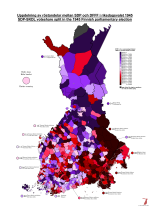
Finland 1945
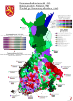
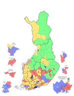
  • I've been returning to Finland again in "preparation" for their election in April, and updating the historical maps I made a few years ago to fit the current format. As a byproduct of this, it occurred to me that it would be interesting to map the relative voteshares won by the SDP and SKDL in each municipality in the March 1945 general election, since the split happened shortly before (the Communist Party had its organising ban lifted in September 1944 as a provision of the Moscow Armistice, and the SKDL itself was formed in October as an umbrella organisation for the Communists, left-wing splinters off the SDP and various civil society organisations) and the two parties won more or less equal shares of the vote (25.1% for the "rump" SDP and 23.5% for the SKDL). The SKDL didn't derive anything like all of its votes from the SDP - the two parties combined won some 825,000 votes, compared to 515,000 for the SDP in 1939 - but mapping the split still allows us to see which regions tended to favour which side of the Finnish left in an almost 50-50 situation nationally.

    val-fi-1945-skdl.png
    (There's quite a bit of Finnish missing from this, because it's not a language I actually speak and the terms I need can't be easily taken off other places)

    A couple of things are very clear: firstly, and perhaps unsurprisingly, Karelia did not like the SKDL one bit. It's worth noting that residents of the areas ceded to the Soviet Union were spread out across Finland and did not vote in their "home" municipalities, but rather through polling stations set up in the municipalities to which they'd been relocated. In light of this, it shouldn't be a huge surprise that they weren't keen on voting for a party that was more or less officially supported by the country whose army had just driven them from their homes. However, the antipathy towards the new party seems to have been a thing across historical Karelia (constituencies 6, 7 and 10), even the regions that remained Finnish after the war - perhaps being near the Soviet Union was enough to sway them away from communism. In either case, they would largely remain loyal to the SDP throughout the Cold War, through all the slow shifts that changed the balance between the two parties over the decades.

    On the other side of the divide, northern Finland was mostly an SKDL bastion, and would also remain so for decades to come. This was especially true of the industrialised areas along the Gulf of Bothnia coast, Raahe, Kemi and the Oulu suburbs becoming huge strongholds for the party - Kemi continues to vote for the Left Alliance on most levels to this day, even after the party lost more than half of its voter base in the 1980s. Helsinki and Turku also mostly sided with the SKDL, and while Helsinki would swing back to the SDP in fairly short order, the presence of a militant shipbuilders' union in Turku ensured that the city would remain strong for the SKDL for a very long time. The old SDP strongholds in Häme and Satakunta were divided between the two sides, with Hämeenlinna and Pori favouring the SDP while smaller towns like Loimaa and Hämeenkyrö sided with the SKDL. The same was true of Vaasa County, where all the towns except Vaasa itself voted SDP while the SKDL had more of a presence in the countryside - of course, rural Ostrobothnia, whether Swedish- or Finnish-speaking, has never exactly been a left-wing region, so this might not actually say much about the overall distribution of support.

    In general, the map above has a crucial flaw in that it makes it impossible to tell where the left as a whole was strong and where it was barely present - for example, Åland's leftist voters almost all voted SKDL, but there were also rarely more than a two-figure number in any municipality. Rather than try to figure out a way to show both scales in a single colour scheme, here's the complete map of the 1945 election so you can see where either of the left-wing parties won and where the others were dominant.

    val-fi-1945.png
     
    Estonia 1923
  • Since I already had a basemap (and a much more legibly-scaled one than the Latvian one, at that), this came together pretty quickly.

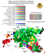
    Estonia and Latvia shared some common denominators in the years immediately following independence - the two biggest parties were a social-democratic one descended from the local Mensheviks (the Estonian Social-Democratic/Socialist (after 1925) Workers' Party (Eesti Sotsiaaldemokraatiline/Sotsialistlik Tööliste Partei, ESTP)) and a right-leaning agrarian movement in which several of the most prominent leaders of the independence movement were involved (the Farmers' Assemblies (Põllumeeste Kogud, PK)). However, Estonia also had a number of other significant parties, most notably the Labour Party (Eesti Tööerakond, ETE), a party of the "non-Marxist left" which consciously modelled itself on the French Radical Party. Its founder, Jüri Vilms, one of the most radical independence activists, disappeared in Finland in 1918 under mysterious circumstances (he's believed to have been captured and executed by the Finnish White Guard's German allies, who did not recognise Estonian independence and saw Vilms as an obstacle to their plans to install a German-dominated government in the Baltic provinces). This did nothing to undermine the party itself, and in the 1919 Constituent Assembly election, they won 30 out of 120 seats, which alongside the 41 won by the ESTP was enough to ensure a working left-wing majority.

    Which in turn ensured that the Estonian constitution came out quite different from the Latvian one, being generally a much more radical document. It declared the principle of popular sovereignty inviolable, and gave a large number of rights to the citizens including free education, free access to science and art, wide-ranging cultural autonomy for ethnic minorities, and the right to strike. The Constituent Assembly also passed a wide-ranging land reform law that was intended to break the power of the Baltic German aristocracy and ensure that rural Estonians were able to live off their land and work. In the political sphere, it followed one of the most radical interpretations of "popular sovereignty" in history, instituting a broad-ranging system of popular initiative and referendums (including to change the constitution itself) and structuring the government on an incredibly strict parliamentary basis. Although lip service was paid to Montesquieu's principles, in practice the Riigikogu (national assembly) held nearly absolute power over all other branches of government. There wasn't even a ceremonial presidency - the head of the cabinet appointed by the Riigikogu (styled riigivanem, which literally translates to "state elder" or "elder of the nation", vanem (elder) being the traditional title of a village head or small-town mayor in Estonia) was also the constitutional head of state, and could be removed at the assembly's pleasure.

    The first elections to a permanent Riigikogu, for which I unfortunately haven't found any detailed results whatsoever, were held in November 1920, a few months after Estonia signed its peace treaty with Soviet Russia and received a very favourable settlement of its eastern border. These elections saw the two governing parties take huge blows, with the ESTP in particular losing a big share of its voters either to abstention or to front organisations for the banned Communist Party. The latter were especially strong in Tallinn, where the Bolsheviks had had a significant stronghold prior to the independence struggle, and the 1920s would see radically different vote splits on the left depending on whether or not there was a significant Communist front active in any given election (very much like the situation across the water in Finland). Also complicating the picture was the Independent Socialist Workers' Party (Iseseisev Sotsialistlik Tööliste Partei, ISTP), which you can basically think of as an Estonian USPD - their roots were a bit different, coming in part out of the old Estonian branch of the SRs, but they filled the same niche in the party system.

    The 1920 elections also saw a good showing for the Farmers' Assemblies, who won over 20% of the vote and nearly beat the Labour Party into first place. Their leader, Konstantin Päts, now became head of state leading a coalition with Labour, the Estonian People's Party (Eesti Rahvaerakond, ERE) and the Christian Democratic Party (Kristilik Demokraatlik Partei, KDP). Päts had been a known figure since the 1890s, editing one of the first Estonian-language newspapers (Teataja, which I believe means something like The Observer or The Gazette) and staking out a position that was at once radical in its demands for self-determination and pragmatic in the ways he went about this. He played a significant role in the independence struggle during 1918 and 1919, including leading the provisional government, while stopping short of being an Estonian Piłsudski - for one thing, his military merits were almost nonexistent, and he would always lean on his political ally General Johan Laidoner, a twenty-year Russian army veteran, to back up his words with force. Päts' most fierce rival through all this was Jaan Tõnisson, the Tartu-based editor of the rival Postimees (The Postman) newspaper, who had a much more academic and cultural approach to politics, criticising Päts both for being too uncompromising towards Russia (Tõnisson served in the First Duma in 1906, while Päts was driven into exile and sentenced to death in absentia for promoting treason against the Russian Empire) and for giving too much of a role to Germans and Orthodox nationalities in what was supposed to be a purely Estonian, Lutheran national project. The ERE was essentially Tõnisson's support organisation, promoting a more conservative brand of nationalism alongside a general centre-right programme, and its support was strongest by far in the Tartu region. Despite their long rivalry, Päts and Tõnisson recognised that they had a mutual interest in preventing further socialist reforms, and this was not the last time they would cooperate in government.

    The Labour Party left the coalition in October 1921, but Päts carried on leading a minority government for an entire additional year until his government fell due to a corruption scandal in the newly-established national bank (Päts himself was part-owner and chairman of the Harju Bank, one of Estonia's largest private banks, and was known to reward political allies - I don't know the details of this particular scandal, but it's easy enough to imagine). This paved the way for Labour to return to power under the amazingly-named Juhan Kukk, who included the ERE and the Farmers' Assemblies in his government, and doesn't seem to have distinguished himself - he held the fort until April 1923, at which point the Riigikogu was dissolved.

    The electoral system used to elect the Riigikogu were very similar to that of the Latvian Saeima, with 100 seats elected proportionally in local districts according to a simple D'Hondt system. However, where Latvia grouped its districts into five large constituencies, Estonia left almost every county as a constituency unto itself, with the result that they ranged in size from 3 to 21 seats. Tallinn was separated from Harjumaa, and Valgamaa and Petserimaa, which were both small and newly-created to cover areas that had been added to Estonia since 1918, were grouped with the larger Võrumaa for electoral purposes. There were no levelling seats, but there were enough large constituencies that small parties could easily get in even without them - it was just that only voters in the larger counties would get the privilege.

    The main story of the 1923 election was the collapse of the Labour Party, whose left-wing credentials were seriously tarnished by three years in government with the likes of Päts and Tõnisson. In their place, the rural left-wing constituency went partially to the new Settlers' Group (Asunikkude Koondis), which would become a major player in Estonian politics as the promises of the 1919 land reform law failed to materialise, and partially to the latest Communist Party front, the Workers' United Front (Töörahva Ühine Väerind, TÜV). The TÜV appear not to have been able to organise in Tallinn, because the result there was deeply weird and turnout quite low (by some sources less than 50%, compared to a national average of 67%). The ISTP began a slow collapse that would see them wiped off the political map by the next election, but nonetheless the 1923 elections presented the most fragmented result in Estonian history. The Farmers' Assemblies finally became the largest party in Estonia, but without actually gaining much in the way of votes, while the situation was complicated slightly by the arrival of a significant (well, four seats) bloc of Russian minority representatives in addition to the pre-existing German bloc.

    To further complicate things, there wasn't a clear majority for the right or the left even if either side had been able to unite around a programme for government. The only option left was to return to the 1920 formula, now with the Labour element even further reduced compared to the right-wing parts of the coalition. So in August, Konstantin Päts returned as head of state for what would turn out to be far from the last time.

    val-ee-1923.png
     
    SVFI: riksdagen 1950-71
  • Seats in the Lower House of the Riksdag, 1950-1971
    during the Emergency Period

    1682810745542.png

    Agriculture: 50
    Mining: 25
    Manufacturing: 25
    Consumer Industries: 25
    Commerce: 25
    Culture: 15
    Employees' Organisations: 25
    Public Administration: 25
    Elected by Local Government: 75
    Nominated by Royal Majesty: 50
    Total: 340

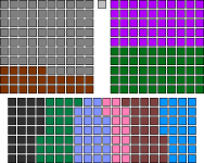
    The Revolution of 1946 brought about a complete overhaul of the Swedish body politic. Though ostensibly launched to defend the social order from "Communist designs", a fear that seemed to have been substantiated when the Rosen Government's backbenchers forced it to commit to major nationalisations and agrarian reforms, its initiators would end up remaking Swedish society in a far more deep-seated and lasting way than their enemies had ever managed.

    The new Council of Government, led by Chancery President Johan Adolf Boberg (a civilian, although he had formerly been an Army officer and maintained contacts with the officers who led the coup), was originally intended to be a temporary affair - as these things so often are - however, they were determined to root out the "societal ills" that had created a situation where a coup was "necessary" to begin with. To this end, with the backing of the King (although his exact degree of willingness has been debated by historians), they promulgated several "special ordinances" (särskilda förordningar) over the period from the Revolution in April 1946 until October 1949. The first of these ordered the Riksdag dissolved and empowered the Council to make ordinances with the force of law in its absence, while the second dissolved all existing political parties and enabled the dismissal and ban from politics of any official suspected of "seditious activity". When (strictly non-partisan) local elections in 1947 resulted in several high-profile opposition figures winning local office, an additional ordinance was passed that abolished local democracy in a list of "strategically important" municipalities and empowered the central government to appoint mayors for them. And, of course, the noose continued to be tightened around actual militant opposition to the new order - after a demonstration in Stockholm in spring 1949, sixteen activists and trade union organisers were sentenced to death for insurrection. Five of them were executed, sparking an additional wave of protests and eventually the birth of underground resistance movements.

    When, on its fourth anniversary in March 1950, the Council of Government announced that a new Riksdag would be elected the same autumn, many hoped it was the light at the end of the tunnel. However, they would be deceived. The new Riksdag would be completely different from the old one - the old one had consisted of party representatives elected by universal suffrage, both of which the Council's members regarded as evils that had helped bring the spectre of communism into the electorate's heads. Instead, the new election law drew inspiration from the ancient order of the Swedish state, and specifically its system of elections by estate. The old four estates - nobles, clergy, burghers and peasants - were not brought back as such, although the former two orders continued to be represented in the Upper House. Instead, the law listed seven social corporations which would each be entitled to elect a set number of representatives in the Lower House - agriculture (so the farmers technically did form an estate again), mining, manufacturing industries, consumer industries, commercial trades, cultural trades, employees' organisations and public officials. In addition, seventy-five members would be elected by the local government bodies of each county, while another fifty were nominated by the King with the advice and consent of the Council.

    Needless to say, although each corporation was theoretically allowed to choose its representatives freely, in practice almost the entire chamber was composed of government supporters. Each corporation had an official organisation run by government allies, which nominated slates of candidates that were elected with only token opposition. The indirectly-elected local government representatives, similarly, were chosen by local bodies that had by this point been thoroughly purged, and every one of its number was on side. Finally, the nominated members included all members of the Council as well as most senior government and military figures, who would be able to control the chamber from within even if the rest of its membership turned out less than reliable. In short, no dissent would enter the Riksdag, and while the new chambers did pass a new constitution, the Instrument of Government 1951, in fairly short order, it was a highly authoritarian document that codified most of what the Council had previously done, as well as giving it sweeping emergency powers. The "Riksdag of the Corporations" would be elected four more times, with five-year intervals, and no major changes were made to its composition in that time. It was only after the scandals surrounding the 1970 elections, the Red Spring and the Revolution of 1971 that free multi-party elections would return to Sweden.
     
    Last edited:
    Turkish Senate (composition)
  • Between 1961 and 1980, uniquely in its history, Turkey had a bicameral parliament. The 1961 military coup, somewhat paradoxically, had been aimed at making Turkey a safe place for democracy by resetting the political process and preventing any one party from amassing near-absolute power in the way the Democrats had over the 1950s (or so the coupmakers believed, anyway). A classic way to do this in constitutions is to create an upper house to serve as a check on the lower house, and such was the intention with the creation of the Senate of the Republic (Cumhuriyet Senatosu) in 1961.

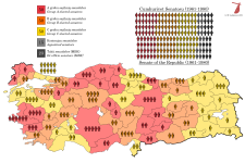
    The Senate differed from the National Assembly (the lower house) in a number of key ways. Firstly, while the Assembly was elected all at once to a four-year term, subject to early dissolution, the Senate would be elected to staggered six-year terms, with a third of the membership up for election every two years. This made it similar to the US Senate, but it differed in that the provinces were still represented somewhat according to population, with Istanbul getting ten seats while most provinces had between one and three. The electoral system was FPTP in single-seat provinces and bloc vote in the rest, i.e. the same system that had been used to elect the National Assembly up to this point (although that switched to PR from 1961). The other key difference was that the Senate, in addition to 150 elected members, also included 15 members appointed by the President (kontenjan senatörler, literally "contingent senators"), who were required to be university graduates over 40 years of age who had done some kind of public service for at least six years prior to appointment, as well as a number of ex-officio senators (tabii senatörler, literally "natural senators") which fluctuated, but included all 22 members of the National Unity Committee (MBK), the military junta that ruled Turkey immediately after the coup, as well as former Presidents if they were still alive and able to take their seat. Ismet Inönü declined in order to stand for election to the National Assembly in Malatya, a seat he won handily allowing him to take back control of the CHP faction in the Assembly and become Prime Minister in a grand coalition government, and Celâl Bayar was still in prison, so none of the eligible former presidents actually took their seats.

    The first elections to the Senate were held on 15 October 1961, the same day as those to the new National Assembly, and saw all 150 elected seats up for election at once. Once elected, the members (or, more accurately, the provincial delegations) drew lots to determine who would serve terms of six, four and two years, with these forming the A, B and C groups within the Senate respectively.

    val-tr-sen.png
     
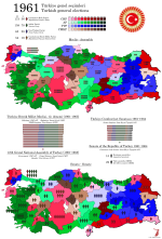
    Turkey 1961
  • Here's the 1961 elections on a reworked basemap, which should both be more accurate than the old one and also allow me to do district-level maps if and when the fancy strikes. Note also the actually correct provincial boundaries in the southeast - I used to have Siirt include all of today's Şırnak province, which was in fact created out of parts of all three provinces that border it.

    So this is of course the first election held after the 1960 military coup, which overthrew the Democrat Party government of President Celâl Bayar and Prime Minister Adnan Menderes. The Democrats had first come to power in 1950, defeating the CHP (Turkey's only legal party until 1946) in the second-ever direct election to the National Assembly. At the time, the electoral system used was bloc vote by province, which allowed the winning party in a given province to make a clean sweep of the seats in almost every case. This, in turn, meant that the winning party on a national level was often able to secure a very wide majority in the unicameral parliament, and by extension close to absolute power. The Democrats were quick to make use of this, fundamentally reshaping the country in a number of ways during their ten years in power. They accepted Marshall Aid and joined NATO, they privatised a number of key state industries built up under Atatürk and his successors, and when Turkey failed to partake of the general economic boom times of the 1950s, they began to threaten opposition politicians and journalists and incited massive pogroms against Istanbul's Greek population in September 1955. In short, Democrat rule turned out to have all the downsides of the CHP era with none of the perceived benefits in terms of national pride and development.

    In 1957, the opposition parties attempted to band together to oust the Democrats, but in response to this, the electoral law was modified to prevent the formation of such an alliance - candidates were prohibited from standing for election under a party of which they were not a member, and all parties standing for election were required to present a full list of candidates in each constituency where they stood. The result was that, despite winning only 48% of the popular vote (a loss of nearly ten percentage points compared to the previous election in 1954), the Democrats captured over two thirds of the assembly. Ironically, it seemed as though the Democrat Party was on the verge of abolishing Turkish democracy, and these fears only became more real over the next couple of years as opposition politicians faced harassment by Democrat supporters and then by the state itself. In April 1960, the National Assembly passed a law authorising a Committee of Inquest, a parliamentary committee with no opposition representation which would have broad power to investigate alleged plots against the government and to issue legal rulings as if it were a court. This immediately met with mass protests led by students and academics in Istanbul and Ankara, which resulted in two deaths and dozens of injuries as protesters clashed with the police.

    Matters were coming to a head, and over the course of May, a group of young officers around Colonel Alparslan Türkeş (who was previously best known as the defendant in a 1944 trial where he stood accused of hate speech and furthering pan-Turkist plots and was sentenced to nine months in prison) decided they might as well be the ones to save democracy if no one else would. After securing promises of support from a few key generals (though notably not the ones in overall command), they formed a junta called the Committee of National Unity (Milli Birlik Komitesi, MBK). On 27 May, troops marched out into the streets of Ankara, and Türkeş issued a statement over the radio declaring martial law throughout the country and calling on all patriotic citizens to "assist in re-establishing the democratic régime the nation desires". The leaders of the Democrat government, including Bayar and Menderes, were arrested and taken to holding cells on the island of Yassıada, one of the Princes' Islands south of Istanbul. There, they would be held for over a year, with some getting tortured and most treated very harshly - Turkish prisons do have a certain reputation. In October, the state brought charges against 592 people associated with the Democrat government, including Bayar and Menderes. The prosecution initially called for the death penalty in 228 of these cases, but at the end of the process, only fifteen people were actually sentenced to death - one of them, former President Bayar, saw his sentence commuted to life in prison because of his advanced age, and would in fact go free in 1966 as part of a general amnesty, only dying in 1986 at the age of 103. Menderes, however, was not so lucky - he had already faced the gallows by the time the 1961 general election was called.

    By then, the MBK had already suffered a major split. As the coup took form, the military leadership was more or less roped into supporting it, and recently-suspended Army Commander General Cemal Gürsel was woken up, flown to headquarters from his Mediterranean retreat and proclaimed leader of the provisional government all while still in his pyjamas. Gürsel was a lifelong military man and a real father to his men, and him taking charge of the coup no doubt helped it maintain cohesion, but there was one big catch: he was a known and longstanding opponent of military interference with politics. In fact, just weeks before, he'd written a farewell letter to the army urging them to "stay away from politics at all costs. This is of utmost importance to your honour, the army's might and the future of the country." Although he had been forced into retirement for gently pushing against President Bayar, and his having come up during Atatürk's final years meant that he was seen as a CHP-leaning figure more or less by default, he does seem to have been quite genuine in believing that the army's role after the coup really was just to reset the democratic order and then hand power to an elected civilian government. This brought him into conflict with a younger clique of officers around Türkeş, who believed they ought to take this opportunity to really reshape Turkish society from the ground up (i.e. establish a fascist dictatorship). This faction suffered a setback in July 1961, when a very liberal new constitution was approved by an imposing yet believable 62% of voters in a national referendum, and in September, just as the nation prepared to go to the polls, 14 of the 38 members of the MBK were expelled and sent off to distant posts, mostly as military attachés at embassies far from Ankara.

    I talked about some of the constitutional innovations of 1961 in the previous post, so just to briefly recap: while Turkey would remain a parliamentary republic with a very powerful legislative branch and a government responsible to it, the new parliament was structured in such a way as to make one-party rule, if not impossible, then at least harder to attain without genuine popular support. The National Assembly, which was reduced in size from 610 to 450 seats, would now be elected by proportional representation, preventing the easy landslides seen in previous elections. To prevent a lot of small parties or (horror of horrors) ethnic minorities from being elected, the electoral law required a party to have an organisation in at least fifteen provinces to stand for election. Meanwhile, a new Senate was created with 150 elected seats which were renewed gradually with a third up for election every two years, in addition to which the members of the MBK were entitled to sit in the Senate by right, while the President could appoint another fifteen prominent figures from outside politics to sit in the upper house.

    The elections were, at long last, held on 15 October, with the entire country electing members to both houses. The early favourites to win were the Republican People's Party (Cumhuriyet Halk Partisi, CHP), who had after all run the government for the entire time up to 1950 and been the main opposition since then. It simply stood to reason that with the Democrats gone, it fell to the CHP to run the country again. However, in their ten years in power, the Democrats had built a formidable political machine, and that wasn't about to go away just because its figureheads had been shown the noose. It simply created a power vacuum waiting for someone to fill it, and that someone did. Ragıp Gümüşpala, the commander of the Third Army during the coup and the most senior general to oppose it openly (his threats against the coupmakers were a key factor behind the decision to bring Gürsel out of retirement), founded the Justice Party (Adalet Partisi, AP) in February 1961, more or less openly as a successor organisation to the Democrat Party. The AP would even adopt the white steed Kırat, a symbol of freedom and justice from Turkish folklore that had been chosen as the symbol of the Democrats because Demokrat sounded a bit like Demir Kırat ("Iron Kırat"), as its own logotype. A less obvious continuity organisation, the New Turkey Party (Yeni Türkiye Partisi, YTP - cue air horns) of former Finance Minister Ekrem Alican, was also quite successful in taking over Democrat votes, especially in eastern Turkey. Finally, the system was rounded out by the succinctly-named Republican Peasant Nation Party (Cumhuriyetçi Köylü Millet Partisi, CKMP) of Osman Bölükbaşı, which was a far-right nationalist and pan-Turkist outfit whose antecedents had existed since the early 50s and which drew much of its strength from the countryside immediately east of Ankara.

    The campaign was quite sedate, if only because the MBK had made sure it would be that way by preventing the main parties from openly criticising it or embracing the legacy of the Democrat government. There wasn't actually that much poll movement between 1957 and 1961, if you ignore the fact that the Democrat Party had been forcibly dissolved and split into two new parties - the CHP actually ended up losing a few percentage points in the popular vote, but the new electoral system meant they still gained a bunch of seats and became the largest party in the new assembly. The AP wasn't far behind, however, and between it and the YTP, there was a near-majority (223 seats) for the Democrats' heirs, leading to the quip that Menderes had won the election from beyond the grave. Still, Gürsel was not going to allow for the new government to be the exact same as the old one, so he invited İsmet İnönü, as the leader of the largest party in the lower house, to form a government - his eighth. The formula he settled on was a grand coalition with the AP, with Gümüşpala staying out of the cabinet but supporting it from the outside, while ministerial portfolios were divided about equally between the two parties.

    An interesting quick I'd be remiss not to mention, by the way, was that the CHP seems to have derived most of its strength from being in second place across most of the country - which makes sense given how the other parties took over sections of the old Democrat machine, which were each dominant in their respective regions. However, this did them no favours in the Senate elections, which were still held under the old bloc vote system. As a result, although the CHP topped the polls across the country on both ballots, the AP ended up getting almost twice as many seats in the Senate, while the YTP also almost equalled the CHP's seat count. This was not to last, however, at least not in the latter case.

    val-tr-1961.png
     
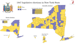
    New York 1847
  • Sometime in the 1810s, New York overtook Virginia to become the most populous state in the United States, a position it would retain until being overtaken by California in the early 1960s. New York's growth in this era was predominantly caused by two factors: the development of New York City as North America's primary harbour, and the rapid and dense settlement of western and central New York largely by population overspill from the New England states, whose meagre farmland was unable to support its growing population. Both of these had been made possible by the construction of the Erie Canal, the biggest public works project of its generation, which created a navigable seaway from the east coast to the Great Lakes for the first time. The agricultural and industrial products of the Midwest, rather than going down the great rivers to New Orleans, now increasingly moved through New York, and this created a huge industrial boom in the state which in turn led to great demand for labour. It's at this time that New York became known as the "Empire State", and it was these historic forces that would lead New York City to become the world's largest metropolis in a few decades' time.

    At the same time, however, New York's political and economic structures were falling behind the times. In the Hudson Valley, most good farmland was still owned by a few old Dutch and English families, whose rights to the land had once extended as far as feudal jurisdiction (what was known as the patroon system). The Revolution had led to a reduction in the power of the patroons, but their influence still reached far and wide, and for most small farmers in the region, the norm was to lease one's land from a patroon rather than own it outright as per the Jeffersonian ideal. Matters came to a head in January 1839 on the death of Stephen Van Rensselaer, considered the last of the great patroons in the Albany region (the manor of Rensselaerswyck), who had made himself popular with his tenants by offering them low rents and being extremely forgiving of late payment. When he died, however, his estate was in financial trouble owing to the Panic of 1837, and his heirs were significantly less willing to tolerate delinquent rents. This understandably became a sticking point with the tenants, and was made even worse by the general tradition that debts owed to one's patroon would be forgiven on the patroon's death. Where the tenant farmers of Rensselaerswyck expected to be rid of a financial obligation, instead they now faced collection agents who refused to take no for an answer. On the Fourth of July, a mass meeting was held on the Helderberg plateau, west of Albany, which issued a declaration stating that they would "take up the ball of the Revolution where our fathers stopped it" and secure freedom for the common people by any means necessary. There followed a few years of low-level violence and confrontations with law enforcement, never quite evolving into a proper rebellion but also never dying down, which has become known to history as the Anti-Rent War.

    The political establishment was quite unsure of how to deal with the anti-rent movement - on the one hand, property rights were one of the chief principles of the American state, but on the other hand, pretty much everyone recognised that a tenant farmer rebellion was very far out of line with their ideals and made them look downright British. A number of governors (New York's governor served a two-year term at this time) came and went and proposed differing solutions to the crisis, in general starting with benevolent reform proposals that then got buried by the legislature or were overtaken by other matters and ending up discrediting themselves by being forced to call out the militia against the tenants. This pattern was only broken with the election of Silas Wright in 1844, who was openly aligned with the patroons from the beginning. This led to a series of riots through 1845 that were all put down violently, breaking the anti-renters as an insurgent force, but scandalising popular opinion and causing a new groundswell of support for their goals. As a result, not only did Wright lose re-election in 1846, momentum against the established order was strong enough to convene a constitutional convention.

    The 1846 Constitution, along with reforming the state's tenancy laws in such a way as to force the dissolution of the feudal manors, also reformed the state's political system along thoroughly Jacksonian lines. The courts were reorganised to abolish colonial holdovers and create more straightforward jurisdictional divisions, and as an anti-corruption measure, all the state officials that had previously been elected by the legislature were now to be elected directly by the people. This included the core of the state cabinet, which weirdly were elected in gubernatorial off-years, as well as the three Erie Canal Commissioners and the three Inspectors of State Prisons, who were to be elected in staggered three-year terms with one seat up for election each year. In addition, the legislature was changed over from the previous multi-member districts (the Assembly was elected by county, while the Senate was elected from larger divisions) to a system of pure first-past-the-post elections, quite possibly the first such case in the US - certainly an early one. The Senate would now be elected from divisions of the entire state, while each county (aside from Hamilton, which consisted - and still consists - largely of uninhabited forest in the Adirondacks) would continue to be allowed at least one assemblyman each, with the rest distributed according to population. The change from the previous constitution being that, rather than larger counties electing their delegations at-large via bloc vote, they would now be required to draw single-member districts that would be contiguous, compact and roughly equal in population. Obviously, this was not as strict as it would be today, but it was still a major step towards the current electoral system used in virtually every US state.

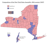
    By the time of the first elections under the new constitution, the 1847 midterms, the New York Democrats were in freefall. Wright's tenure as governor, and his controversial renomination in 1846, had created two strong factions within the party, and these were further animated by the Wilmot Proviso (the proposal to ban slavery in all territories gained from Mexico) and the growing conflict over the institution of slavery. On the one hand were the radical faction known as the "Barnburners", who supported decisive action against landlords and banks to root out their abuses, and were thus likened to a farmer who deals with a rat-infested barn by burning it to the ground. The other side, dubbed the "Hunkers", consisted essentially of Wright's faction, although Wright himself died in 1847 before he could really participate in the factional conflict, and supported economic institutions and public works while opposing public debate over slavery. The 1847 party convention was dominated by the Hunker side, and the Barnburners withdrew from it in protest, refusing to support the nominated candidates. There was discussion of proposing a separate Barnburner ticket of candidates, but this ultimately did not come to pass, and some of them ended up supporting the Whig candidates.

    The result was a blowout victory for the Whigs, who won all statewide offices up for election and two-thirds majorities in both houses of the legislature. The Anti-Rent movement, thinking its time had come with the new more democratic constitution, nominated their own candidate for Lieutenant Governor, who got a few thousand votes and came a distant third, but several of their preferred candidates in other races won office, including Comptroller Millard Fillmore and Attorney General Ambrose Jordan. All these were Whigs, which feels significant and probably indicates that their power as a movement was on the wane by this point.

    val-us-ny-1847.png
     
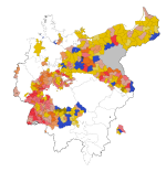
    Germany 1848 (current progress)
  • Okay, so I rather predictably hit a wall after a while. I'm probably going to need old municipal maps of NRW and/or Saxony (@Erinthecute, any ideas on the former?) to be able to carry on, but I'm quite happy with what I got done, and maybe someday I can finish it.

    1689440056006.png

    In case anyone's curious, the seat totals for this are as follows:

    Donnersberg 21
    Deutscher Hof 39
    Radicals 60

    Württemberger Hof 29
    Westendhalle 21
    Left-liberals 50

    Casino 93
    Landsberg 12
    Pariser Hof 4
    Right-liberals 109

    Café Milani (conservatives) 23

    Uncertain/no faction 48
     
    Chicago: Kelker Plan (1923), first phase
  • Now to the real reason I started drawing Chicago - some past plans.

    The system that existed in 1921 had been largely built in the 1890s - the Northwestern Elevated opened its branch to Ravenswood in 1907, and after the four companies pooled their operations in the Chicago Elevated Railways Collateral Trust (CER) in 1911, focus was placed on improving service and increasing connectivity between the different lines rather than extending the system. Which, considering Chicago doubled in population from one to two million between 1890 and 1910 and reached 2.7 million by 1920, was beginning to pose a problem. Especially so considering the city's growth was mainly in the form of outward expansion rather than densification, with new suburbs springing up like mushrooms around the city.

    The city fathers were acutely aware of this, and after World War I they appointed Rudolph Frederick Kelker, an engineer who worked for the city's transportation committee, to draw up a plan for how Chicago's public transportation system could be extended and modernised to meet the needs of a growing city. Kelker's plan, which was published in 1923 under the unwieldy title Report on a Physical Plan for a Unified Transportation System for the City of Chicago (it's usually just called the "Kelker Plan"), called for the rapid transit and surface (streetcar) systems to be unified under a single operator, ideally owned by the city, as well as a large program of extensions to both systems that would bring service to new parts of the city and deal with the chronic capacity issues that already plagued the Union Loop twenty-five years after its opening.

    Kelker divided his plan into two phases: the first phase, costed at $218 million (some $3.9 billion in today's money), included measures deemed immediately necessary to meet Chicago's needs as they were in 1923, while the second phase, for a more modest $155 million ($2.8 billion today), was meant to provide for a population of five million, which was the then-projection for 1950. (It turned out that prediction was about right, except that obviously those five million people were a lot more spread out than people in 1923 imagined they'd be)

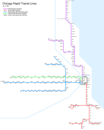
    The map below shows the rapid transit system as Kelker envisioned it after the first phase of construction. Key projects include:
    - A subway under State Street, starting at a portal and a connection with the South Side L around 16th street in the South Loop and proceeding north through the CBD, turning west at North Avenue and connecting to the Northwestern L around Orleans Street (just east of Sedgwick station, quite a bit south of where OTL's State Street subway connected). This was to be a two-track line except for the CBD section, which would be built with four tracks to allow for short turns if needed.
    - Another subway would begin at Blue Island and Maxwell (just south of today's UIC campus), then go east along Harrison Street into the CBD, where it would run under Clark Street, two blocks west of State (and one block west of OTL's Dearborn Street subway), then turn west along Chicago Avenue at its north end and continue as an elevated up to the existing Metropolitan Elevated line at Paulina Street. More on which in a moment.
    - The "Paulina Connector" (a name that would not be used for several decades), the north-south line that connected the Metropolitan L's various branches, was to be separated from it and turned into a new north-south trunk line, running along Ashland Avenue through the Southwest Side to terminate at 87th Street, and connecting to the Ravenswood branch in the north before running on its own alignment along California Avenue to terminate at Howard Street near the city limit. This would also be connected to the Stock Yards branch of the South Side L, which would make commutes much easier for all stockyard workers who didn't live immediately near that line.
    - To go with the mid-city trunk, the Clark Street subway's southern leg would have two branches: one taking over the Douglas Park branch of the Metropolitan (essentially today's Pink Line), and one continuing south along Ashland, then southwest Archer Avenue, and finally south again on Kedzie, serving most of the Southwest Side's more densely-populated areas.
    - In the northwest, there would be two corresponding branches built, one continuing northwest along Milwaukee Avenue and one running west on Belmont Avenue, terminating at Harlem Avenue near the western city limit. The Humboldt Park branch would also be extended west to Austin Avenue, and both it and the Milwaukee Avenue line would have a third track added to allow express service during peak hours.
    - The Milwaukee Avenue L would also be extended southeast from Paulina, connecting with the Lake Street L and running into its terminal on Market Street (today's Wacker Drive). I believe Kelker also made provision for the southwestern branches to run into the Metropolitan's Wells Street terminal, but I decided the area around Ashland and Blue Island looked complicated enough without me trying to map that.
    - The Ravenswood branch would be extended west along Lawrence Avenue to its intersection with Milwaukee Avenue, where both it and the Milwaukee branch would terminate.
    - In lieu of the Northwestern L's North Water Street terminal, a new two-track elevated line was to be built along Austin Avenue (today's Hubbard Street), terminating at the Municipal Pier (today's Navy Pier) and allowing better service to the fast-growing Near North Side. The maps included in Kelker's report only show this line connecting to the Northwestern L from the north, so I assume that would be its only service pattern even though I assume a lot of people would want to travel from there to the CBD. Oh well.
    - The South Side L's various branches would almost all be extended - the Stock Yards branch has already been mentioned, but the Kenwood branch would be extended west to meet both the Southwest Side lines and terminate at Kedzie, while the Jackson Park branch would be extended south to 93rd Street along Stony Island and South Chicago Avenues (fun fact: because of how Chicago's street grid works, South Chicago Avenue's street addresses take the format "XXXX South South Chicago Avenue"). A new branch would also be constructed running due south from 61st Street station and terminating at 127th Street. To provide adequate service for all these new extensions, the main line of the South Side L was to be expanded to four tracks, and a new terminal built at Wabash and Van Buren.
    - Finally, although Kelker (almost uniquely for Chicago transit planners before about 1990) didn't call for the Loop itself to be demolished, he did want its western leg along Wells Street to be grade-separated from the rest of it, and a short new alignment built south along Wells to Polk and then east to connect to the South Side L. This would allow two alternate two-track routes running north-south through the CBD, effectively creating a four-track corridor all the way from Howard to 61st, and a separate alignment for the "West Side Group" of lines, i.e. the Lake Street and Metropolitan main lines, which Kelker envisioned forming one of the four key trunks of the network.

    chicago-kelker-ph1.png

    So what parts of this were actually built? Well, not a lot. The State Street subway, along with a subway under Dearborn Street and Milwaukee Avenue that more-or-less parallelled Kelker's Clark Street corridor, were both built in the 1940s, though the latter didn't open until 1951 due to wartime construction stoppages, and the Southwest Side did finally obtain L service in 1993 when the Orange Line opened. And right now, as I write this, the CTA is in the advanced stages of planning for an extension to bring the Red Line down to 130th Street, an extension Kelker deemed immediately necessary a full century ago.

    There have also been a lot of outright closures, some probably necessary due to slow and outdated infrastructure, but often also dealing serious damage to communities served. After World War II, Chicago's innermost suburbs would be severely blighted by freeway construction and "slum clearances" that left behind an urban wasteland, and it didn't help when the CTA axed stops in the name of bringing suburban commuters into the city slightly faster, or moved entire lines from busy commercial arteries into the middle of freeways designed to avoid points of density.
     
    Last edited:
    Chicago: Kelker Plan (1923), second phase
  • So, about that second phase.

    The current estimate when Kelker wrote his report was that by 1950, Chicago would have a population of five million - almost twice what it had been in 1920 - and so, as one might expect, Kelker took this growth into account and recommended additional projects to provide the necessary capacity. As mentioned last time, while the growth projections were roughly accurate, Kelker failed to account for the rise of mass automobile ownership and the resulting suburbanisation, so his plan provides interesting AH potential in that it shows what Chicago might've looked like if that development had never occurred. (I personally think it's unlikely to avoid it completely, unfortunately, given the US's large domestic oil supply and the inherent lobbying weight that results, but there are certainly ways in which the total car-dependent hellscape that was post-war US urban planning could've been toned down)

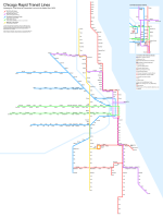
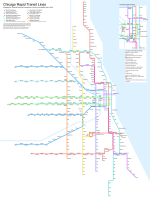
    So the two most important projects in the second phase were both subways: one of them would parallel the lake shore, running from Wilson station on the North Side to Cottage Grove station on the Jackson Park branch - and yes, it would be underground the whole way. At $55 million (nearly a billion dollars today), this was the most expensive single project in the entire plan, and accounts for over a third of the entire second phase's cost all by itself. This new line would relieve the State Street subway massively, and I've had it take over the Ravenswood branch beyond Ravenswood itself in the north as well as the branch to 127th in the south. As a result of the added capacity, I've also removed the South Side L's terminal at Wabash Avenue, which is not something Kelker explicitly recommends (he's generally very reticent about demolishing anything), but which I think makes sense given there are now six tracks running north-south through the Loop.

    The other new subway recommended was to run under Halsted Street, a key north-south artery on the Near West Side, and similarly relieve the Wells Street L as well as the western branches on the South Side. This is another point where I've sidestepped the plan slightly - Kelker recommends connecting this line to the North Side L at its northern end, but I decided it was too much hassle to map a triple line, so I decided to have it terminate at North Avenue instead. Which is probably not its optimal service pattern - I imagine most trains would run north to at least Belmont, and probably as far as Howard, if this had actually been built. I also believe, given the rapid decline of the Union Stockyards post-war, that this line would've provided sufficient coverage to allow the Stock Yards Branch to be demolished - however, again, Kelker assumes they will remain the city's biggest place of employment by far, so he doesn't recommend this.

    Kelker also recommended two streetcar subways be built, one under Washington Street and the other one partly under Jackson Boulevard and partly under Van Buren Street. These would supplement the tunnels already used by the streetcars to cross the Chicago River (fun fact, I guess) and help keep traffic volumes down in the Loop's streets - Kelker seems to lament the necessity of spending money on this, but nevertheless recommends they be built in the second phase because traffic congestion would likely require them. He incidentally has the same attitude to the Loop itself, recommending that it (or rather, its two successor routes, the West Side Group's U-shaped trunk and the separated Wells Street L) stay up but also noting that nothing in his plan would prevent the city from replacing them with subways if the mood should strike.

    Beside these, the second phase also included a number of new elevated lines in the suburbs: most notably one along Kedzie Avenue, which would provide a crosstown trunk west of the Mid-City and also take over the southern part of the old Marquette Park L, which is instead extended down Archer Avenue all the way to the city limit. The Kenwood branch would be extended nearly as far west, while both the Humboldt Park and Milwaukee Avenue branches in the northwest would see extensions out to the city limit. As for the Humboldt Park branch, I've detached it from the rest of the Northwest-Southwest routes on here, and this is because of what may be the most baffling line in the entire plan: the Clinton Street L. Kelker simply notes that the Near West Side is growing in importance and density, and that a link will be needed to serve this density, and therefore recommends a new elevated line along Clinton Street between the two West Side routes. The most obvious service pattern for this would be as a simple short-turn of the West Side trunk, but I decided to instead link it to the inner portion of the Milwaukee Avenue L, a line that was itself always very strange, and create a new service linking the Humboldt Park branch and the four-track part of the former Metropolitan main line. On the latter, I think it's very likely that a local-express stopping pattern would be established, with the new line most likely running local to the West Side trunk's express given the relative lengths of the two, but I haven't depicted this on the map.

    So this is the final buildout. This system would have 421 miles of revenue track, compared to 162 in the extant system as of 1923, and while I didn't count the number of stations I put in, there were substantial capacity increases along nearly every corridor, with Kelker estimating a capacity of 400,000 passengers per day in the first phase of construction alone. For the record, the L today carries about 320,000 passengers per weekday (although it was close to double that before the pandemic).

    Kelker's plan would be the last major one to assume that rail would remain the predominant form of urban transportation - the next tranche of plans, published in 1937-39, were adapted for an age of growing automobile use and tried to have the rail system coexist with a new network of urban motorways. This would be the model eventually followed once Chicago's economy recovered from the Great Depression and World War II, and the results have been somewhat mixed, as discussed in the previous part.

    chicago-kelker-ph2.png
     
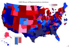
    U.S. House 1968
  • And another project, this time an old one I was reminded of by my rail mapping and decided to finish off.

    In the National Atlas of the United States, in addition to a large selection of general reference maps and the rail map I've been using, there is a map of congressional districts in use as of the 1968 election. Putting this on the @Chicxulub county basemap gives us a very nice view of how legislative elections in the US looked at the time, and indeed for most of the Cold War era.

    This election was held at the same time as the 1968 presidential election, which is usually considered one of the great realigning elections in US history - Richard Nixon was able to win a majority in the Electoral College, partly off of the old Republican strongholds in the Midwest and West, but also thanks to the Republicans breaking into the old Democratic strongholds in the South. The only former Confederate state that voted for Hubert Humphrey in 1968 was Texas, probably in large part due to the influence of outgoing President Lyndon B. Johnson. Because, while the Republicans won several southern states, another four voted for the third-party campaign of George Wallace, who was nominated in place of Humphrey by several state Democratic parties in the Deep South. In Congress, however, very little trace of this was seen: the South remained very staunchly Democratic, while much of the rest of the country was split between solid Republican and solid Democratic districts.

    The reason for this is relatively simple: in 1968, the parties were still ideologically incoherent, with a large liberal wing in the Republican Party and a very large conservative wing in the Democratic Party. A Republican from Massachusetts could easily be substantially to the left of a Democrat from Mississippi, and once elected, members tended to form coalitions based more on ideological affiliation than party affiliation (especially between conservatives in the two parties). And while the parties still mattered in some ways - notably, their relative strength in the House determined who could set the legislative agenda and who would get leading positions on committees - the way this worked also rewarded those representatives from each party who had the highest seniority. This meant that a district whose member had served longer would get more influence in Washington, and by extension, that keeping an incumbent in office was almost always advantageous. For this reason, I've marked the few seats that didn't have an incumbent representative with asterisks, to let you see where this did and didn't correlate with the few relatively close races.

    val-us-1968.png
     
    U.S. House 1912
  • I'm very glad this latest change in theme seems to have brought some interest, because there's more congressional maps coming.

    We start this series in 1912, an interesting year for a number of reasons. Firstly because it was the last really properly three-cornered presidential race in U.S. history - in 1968, while Wallace ran a nationwide campaign with a nationwide party, he got very limited traction outside the South and even he would probably have candidly admitted that he wasn't trying to win the presidency outright, and in 1992, Perot got a reasonably impressive nationwide voteshare but won no states and wasn't really close to winning more than a handful of electoral votes. In 1912, however, there were three candidates heading nationwide organised political parties who all had significant pockets of strength around the country, although it was pretty clear from the beginning who was going to win.

    The Progressive Era, which was at or near its absolute zenith in 1912, was a weird period in American political history. Generally, most American party systems consist of one "active" political party, whose formation or adoption of a new program signals the start of the party system, and a "reactive" party, who form as a broad coalition in opposition to the active party and tend to be a lot less ideologically coherent. From 1860 until about 1890, the Republicans had been the active party in American politics, formed on a platform of opposition to slavery, American nationalism and an economic policy that combined government aid for economic development (particularly rural economic development) with protectionist trade policy and strong support for big business, and gathering a coherent bloc made up of businessmen, small-town notables, farmers and Protestant churches. Opposing them were the Democrats, left over from the previous party system, and combining their old Jacksonian populist element with urban machines, Catholics and immigrants as well as the white supremacist bloc in the South, which by 1890 was completely and utterly dominant across most of the region. It was an extremely weird amalgam of interests, but through most of the period, control was maintained by a pro-business faction known as the Bourbon Democrats, who ensured that the party mostly differed from the Republicans in wanting lower tariffs and a weaker federal government. The main divide among voters had less to do with ideology and more to do with the legacy of the Civil War - if you or your family fought for the Union or otherwise identified with its cause, you probably voted Republican, and if you didn't (whether that was because you disagreed with Lincoln's conduct in office, because you were on the Confederate side, or because you came to America after 1865 and didn't have a stake in the matter), you probably voted Democratic.

    By the 1890s, however, things were slipping. Grover Cleveland's presidency, usually regarded as the peak of the Bourbon Democrats, resulted in new battle lines being drawn, with a number of anti-corruption Republicans breaking with the party to support Cleveland against James G. Blaine, who was widely suspected of having sold favours to railroads during his time as Speaker of the House. On the Democratic side, meanwhile, Cleveland's conservatism drew the ire of the populist wing of the party, and after the Panic of 1893, his critics were able to take full control of the party. The 1896 DNC, dominated by southern and western anti-Bourbon interests, resulted in the nomination of William Jennings Bryan, a young firebrand from Nebraska who seemed to run against everything Cleveland stood for. The nascent People's Party, an organisation of farmers and rural workers in the West who had won a few electoral votes in 1892 and had a decent-sized bloc of seats in the House of Representatives, cross-endorsed Bryan, and the stage seemed set for a new realignment along something more like what we might recognise today as left-right lines.

    Yet this never happened. Perhaps it was too early in 1896, a time when many thousands of Civil War veterans were still alive and the legacy of the conflict still shaped politics, for the political divide created by it to simply go away. Regardless, the Democrats and Republicans continued to operate, and indeed still continue to operate to this day. Bryan's crusade against the bankers and plutocrats who would "crucify mankind upon a cross of gold" did not convert the Democratic Party into a vehicle for progressive reform, and indeed conflict would continue to rage between his faction and the legacy Bourbons right up until FDR forced them together to combat the Great Depression.

    Instead, the Progressive Era would come to be defined by these internecine struggles between progressive and conservative forces within each party, and it was a Republican who would implement most of the key progressive demands. In 1900, as William McKinley ran for re-election, he was persuaded to accept Governor of New York, and leading progressive Republican, Theodore Roosevelt as his running made. This was done partly as a sop to progressives within his own party, partly to neutralise Bryan's message in his second run for the presidency, and partly because the New York Republican machine wanted to neutralise Roosevelt by kicking him upstairs to a largely-powerless federal office. This backfired spectacularly the next year, when McKinley was assassinated while visiting the Pan-American Exposition in Buffalo, and Roosevelt assumed the presidency. He would serve for almost two full terms, winning re-election in 1904 and retiring in 1908, handing power to his hand-picked successor William Howard Taft.

    Taft would go on to alienate Roosevelt and his progressive faction in office. There's been raucous historical debate over how much of a conservative Taft actually was - he continued many of Roosevelt's initiatives, and would later argue he'd gone further to break up trusts than Roosevelt had. According to this line of argument, Roosevelt moved to the left after his presidency, arguing for a "New Nationalism" which included things like social insurance, inheritance taxes, an expanded right to strike and campaign finance regulations, and while Taft continued to implement the agenda of Roosevelt's presidency, he did not support his mentor's new tack. According to Roosevelt's supporters, meanwhile, Taft had been captured by big business and was now a full-throated enemy of their movement. Wherever the truth lay - and there was probably some truth to both sides of the argument - Taft and Roosevelt became the standard-bearers for the opposing factions of the Republican Party heading into the 1912 election.

    It pretty quickly became clear that the Republican state organisations mostly favoured Taft's more moderate line, and that the convention would be dominated by the conservative faction. Roosevelt's supporters blamed this on the large Southern contingent at the convention, which was both firmly conservative and hugely overrepresented relative to the number of Republican voters in those states. Disputes over this led most Roosevelt supporters to abstain on the nomination ballot, and when Taft won the nomination on the first ballot, they walked out of the convention. They hastily organised a convention for a new "Progressive Party", which nominated Roosevelt unanimously and approved a platform, the "Contract with the People", which essentially copied Roosevelt's "New Nationalist" agenda. There was one notable exception - antitrust measures, which had probably been the single most important progressive hallmark of Roosevelt's presidency, was struck from the platform in favour of vague language about "strong regulation". This was blamed on the influence of George Walbridge Perkins, one of the party's key financiers and an employee of J. P. Morgan whose progressivism included arguments for "the Good Trust", and a number of leading progressives declared the new party a lost cause before it really got going.

    Nevertheless, Roosevelt was still personally popular, and a large number of rank-and-file Republicans defected to his campaign, giving him a momentum that easily overpowered Taft's official Republican campaign. Whatever Taft's personal politics might have been, the formation of the Progressive Party left the GOP firmly in conservative hands, and its campaign focused on attacking Roosevelt as a dangerous radical who would change America beyond all recognition and/or an inveterate egotist who was only running to satisfy his vanity and sabotage Taft. It wasn't a very effective strategy, and Taft, as the only status quo candidate in the race, had very few real arguments to sway voters.

    But, of course, there was also a Democratic campaign. And surprisingly enough, even as the Republicans were tearing themselves apart, the Democrats appeared more united than ever. There had been a clamour for Bryan to run again - his fourth heave - but the man himself refused, believing the one thing that could hurt the party's chances at this point would be nominating a three-time loser. This meant a bitterly contested convention, a Democratic Party tradition in the making, which ended up nominating Woodrow Wilson, a southerner who moved to New Jersey to take up a professorship at Princeton University - he'd served both as president of the university and governor of the state by the time of his nomination. Wilson was known as a reformer who took an intellectual approach to politics and shared many progressive goals, but he also appealed to conservatives in the South because he came from there and remained outrageously racist even by the standards of the time. As President, even as his administration made strides on some progressive issues, the federal government was segregated, and the Southern tradition of lynchings and race riots spread throughout the United States with the apparent blessing of the White House.

    Because, in case you hadn't already figured it out, the main effect of the Republican split was to give Wilson a clear run for the White House. He won 40 of 48 states and 435 electoral votes, the largest number ever recorded, despite only gaining some 41% of the popular vote. Roosevelt won another six states, mostly in the West but also including Michigan and Pennsylvania, while Taft won only Vermont and Utah.

    Of course, the map I've made isn't of the presidential election - you can find good maps of that in other places already - but of the congressional election that accompanied it. By 1912, all states elected their congressmen on the same day they elected the President, except Vermont and Maine, which elected their ones alongside state elections in September. This is the origin of the saying that "as Maine goes, so goes the nation" - it wasn't that Maine's election results tended to match those across the country, it was that you could read political trends from their elections because they literally voted two months before everyone else.

    1912 was the first election after the 1910 Census, and also the first after Arizona and New Mexico were admitted to the Union. The Census showed a population of 92 million, up from 76 million in 1900, and the Apportionment Act of 1911 determined that 435 seats in the House of Representatives would be adequate to represent this population. For reasons we'll no doubt get to, this is still the size of the House, even though the country has more than tripled in population since then. Anyway, this represented an increase of 44 seats from the previous election, or 41 counting the three seats given to Arizona and New Mexico in the interim, and with around 210,000 inhabitants per seat, it still represented the largest population-to-seat ratio in U.S. history up until that point. Of course, while the states were technically required to make their electoral districts compact, contiguous and equal, in practice these rules were very loosely observed in a time before the Voting Rights Act.

    This would be demonstrated in more ways than one. While, again, states were required by the Apportionment Act to draw as many districts as it had representatives, the Act also allowed for representatives to be elected at-large (that is, by the entire population of the state) as needed until redistricting laws could be passed. An astonishing fourteen states did this, with Montana, Idaho and Utah electing their two-seat delegations statewide, while another eleven states used a combination of statewide and district elections. Most egregious in this regard were Oklahoma, which gained three new seats but kept using its five districts drawn in 1906, and Pennsylvania, which gained four seats but kept using its 32 previous districts. Even more astonishingly, Pennsylvania would keep doing this for ten years.

    As with the presidential race, the congressional elections of 1912 were a blowout for the Democrats. Even though the House grew by 41 seats, the Republicans suffered a net loss of 28, and the Democrats won a two-thirds majority of seats. Their gains included inroads into strongly Republican regions like Pennsylvania, northern Illinois and rural New England, as well as commanding majorities in their Southern stronghold, which was by now thoroughly established as the "Solid South" with unopposed or nigh-unopposed elections as the norm. All that said, however, the Republicans still fared better than they did on the presidential level - even if many of their supporters backed and campaigned for Roosevelt's presidential campaign, there were only a few cases where the Progressives were able to get any sort of coattails. Usually, this involved incumbent Republican congressmen defecting to the party, and that was quite a rare thing even for more progressive-minded ones. Most of the Republican Party on the state and local levels stayed intact through the split, and in the end the Progressives were only able to win nine seats in the House - substantially less than the 22 seats the Populists had at their peak. Their delegation would only dwindle in size from here, further contributing to the party's image as a flash in the pan that had no basis for existing outside of Roosevelt's campaign. And in spite of future attempts to break the two-party system, the Democrats and Republicans continue to dominate U.S. politics to this day.
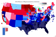
    val-us-1912.png
     
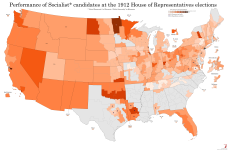
    U.S. House 1912 (Socialist voteshare map)
  • The Progressives weren't the only ones trying to break the two-party system from the left in 1912. In 1901, a convention of left-wing activists from numerous different groups met in Indianapolis and founded the Socialist Party of America, a broad-tent socialist movement that was intended to be the US parallel to organisations like the SPD in Germany or the Labour Party in the UK. Like them, it encompassed a broad range of opinion, from the "Sewer Socialists" of Milwaukee who largely fought for improved public services (hence the name) and didn't differ too much from the Progressives in matters of policy, through Christian prairie radicals like Julius Wayland and Oscar Ameringer, to out-and-out Marxists like Eugene Debs and the other organisers of the International Workers of the World. The party would, in fact, spend most of its existence riven with internal strife over issues like how (and to some extent whether) to oppose racial segregation, whether to focus on electoral politics or syndicalist union organising as a path to power, and most famously, whether to oppose the US joining World War I.

    The fact that the SPA, unlike most mainstream socialist movements in Europe, would come out in full force against the war, and suffer a large amount of state repression as a result, has its explanation in the party's support base. One of its key demographics were immigrant labourers in the mid-sized cities of the North, many of whom had German or Austro-Hungarian origins and were none too keen to see their new homeland go to war against their old one. On the map below, we can see how many of their biggest strongholds - Schenectady, Dayton, Terre Haute, Duluth, Oakland - fit this mould, which incidentally looks a lot like the Labour base at the same time. The only major cities where the Socialists achieved any kind of strength were Chicago and Pittsburgh, which were both also extremely multicultural working-class cities at this time. Milwaukee, the most notable Socialist stronghold, fell somewhere in between the two, being a very large city but also having a solid German-speaking population bloc that would form the main base of Sewer Socialism for the next several decades.

    The other Socialist base, which arguably looks more impressive at least on this map, were miners and subsistence-level farmers in the West, many of whom lived on the edge of starvation and were treated horribly by their employers (or produce buyers and landlords, in the case of small farmers), and so found a natural attraction to the idea of changing the economic structure of society. Perhaps surprisingly to modern observers, the single strongest state for the SPA in much of the 1910s was Oklahoma. The reason for this traces back to the Land Runs of 1889-95, where Congress revoked tribal titles to the land that had been Indian Territory, causing a flood of white settlers from neighbouring regions who were eager to claim a piece of the American frontier before it closed for good. Because of the lack of preparedness of many of these settlers and the specific conditions of their arrival, a large majority found themselves either destitute or one bad harvest away from destitution, and this made the then-territory fertile ground for Populist, and later Socialist, organising. Many of the settlers found a temporary solution to their desperate situation in selling their land claims to railroads or other big businesses and leasing it back, which only ended up sending them further into poverty and further into radicalisation. The Socialist Party of Oklahoma, at its peak, commanded the support of some 20% of the electorate, but suffered a particularly brutal crackdown after 1917 and never really returned to prominence.

    As far as I know, 1912 was the best Socialist performance in any US federal election, in spite of the fact that they won no seats. Eugene Debs, who was nominated as the SPA's candidate for President on a cross-faction unity ticket with Sewer Socialist Emil Seidel, won just shy of 6% of the popular vote, but the party's congressional candidates actually outdid him by some margin, winning 7.9% of the vote across 335 candidates - one of the largest slates put up by a third party in the 20th century, and more than half again as many as the Progressives. Then again, this broad slate of candidates may have hurt the party as much as it helped, because again, none of them got elected. This illustrates pretty clearly the difference between Progressive and Socialist paths to power - one was a top-down movement of reformist politicians and concerned high-profile citizens, with a large amount of name recognition for their leading figure(s) and a severe lack of ground game, while the other was a bottom-up movement of trade unionists and agitators who gathered a large organising base but was only able to break through in the few places where they obtained prominence.

    The SPA would only ever send two representatives to Congress, though never more than one at a time, and as mentioned, neither won their seat in the party's best election. Victor Berger, one of the leading Sewer Socialists, had won election to Congress from the north side of Milwaukee (WI-5) in 1910, but was defeated in his bid for re-election by Republican candidate W. H. Stafford - the two would alternate in the seat until 1933. The other Socialist congressman was Meyer London, who won his seat on the Lower East Side of Manhattan (NY-12) in 1914 and served three non-consecutive terms ending in 1923, but his time had still not come in 1912 as the Democratic incumbent held the seat.

    val-us-1912-soc.png
     
    Johannesburg 2021
  • This is the first in what may end up becoming a series - I did a map of Cape Town ages ago, but there's been another election since then, so I'll have to go back and update it sometime.

    Johannesburg Metropolitan Municipality had a population of 4.4 million as of the 2011 census, and it's likely to have grown by more than a million since then (the following census was delayed to 2022 due to COVID-19, and still hasn't been published). This number is especially impressive considering the city's boundaries, which, in spite of the general push to unify metropolitan areas following the end of apartheid, still stop a short distance east and south of the city centre. The East Rand area, covering a number of satellite cities and townships east of Johannesburg, was made into a separate metropolitan municipality, Ekurhuleni (a Tsonga word meaning "place of peace"), and a number of outer western suburbs were left out of the "unicity" as well. However, the municipality is still extremely diverse and divided, with both affluent suburbs like Houghton, Rosebank and Sandton and townships like the famous Soweto as well as Ivory Park and Alexandra. The latter, despite being one of the poorest and most densely-populated urban areas in all of South Africa, is surrounded by much wealthier areas, making one of few breaks in what's otherwise a very stark socioeconomic divide between the city's northern and southern suburbs. The CBD itself was reserved for whites during the apartheid era, as were most of the inner suburbs, but following the democratic breakthrough, most whites decamped the area leaving it impoverished and crime-ridden. Things have started to get better again, but revitalising the city core remains one of Johannesburg's major challenges.

    The council, like the city it serves, is very large - with 270 elected councillors, I believe it's one of the largest local councils in the world, though I don't have a source to back that up. As with every other local council in South Africa, elections are held using MMP, with 135 councillors elected from single-member wards and another 135 assigned to party lists in such a way as to make the overall makeup of the council proportional to the share of votes cast for each party. Like all metropolitan municipalities aside from Cape Town, Johannesburg gave the ANC an overall majority of the council in its first election, and continued to do so until 2016, when the DA made big strides and nearly overtook the ANC in vote and seat share. Since then, Johannesburg City Council has been under no overall control, and things have only gotten more and more fractious over time. The DA's first mayor was Herman Mashaba, who founded a haircare company and earned millions of rand from it, leaving him with the firm conviction that anyone can now make it in South Africa and so all government intervention in the economy is a waste of time and money. He resigned in November 2019, citing differences with the DA leadership, and the ANC were able to claw back the mayoralty under Geoff Makhubo, who was himself deeply controversial because of alleged corruption, but was able to save himself from being forced out of office by the simple expedient of dying of COVID in July 2021. His successor, fellow ANC member Jolidee Matongo, was killed in a car accident two months later, and so the city went into the 2021 elections with an interim mayor.

    As mentioned, the 2021 elections returned an even more unstable council than the 2016 ones, and this was largely due to the return of Herman Mashaba, who broke off from the DA after leaving the mayoralty and formed his own party called ActionSA (that's the full name of the party). The party's ideology largely mirrors Mashaba's own libertarian beliefs, supporting lower taxes and deregulation of business, and also agitates against illegal immigration from other African countries, which its supporters believe is responsible for nearly all of South Africa's economic and administrative issues, including crime, unemployment, stagnant wages and failure to deliver public services. This is of course not backed up by anything, but what's new. ActionSA ended up getting a slightly worrying 18% of the vote across the city, taking votes about equally from the ANC and the DA, although they failed to win a single ward. However, two wards in the south of the city were won by the Patriotic Alliance, a very similar (albeit less economically libertarian) group led by the incredibly-named Gayton McKenzie, a rags-to-riches figure somewhat similar to Mashaba except with a spicier backstory that involves spending time in prison for robbing banks and using this as material for a successful motivational speaking career. The Inkatha Freedom Party also won two wards in the heavily-Zulu inner suburbs of Jeppestown and Denver, heralding a return for the party that seems to be carrying on apace if current polls are anything to go by. Lastly, Al Jama-ah, a party for and by South Africa's Muslim community, won a ward on the southern edge of Soweto.

    Al Jama-ah would become quite important to the development of Johannesburg's politics after the 2021 election, because when the DA-led rainbow coalition that took over after the election inevitably fell apart at the end of 2022, it was Thapelo Amad, one of their councillors, who became mayor with the support of the ANC and the EFF (who, by the way, maintained a steady 10-11% of the vote in both 2016 and 2021). Amad only lasted in office until April 2023, and his successor Kabelo Gwamanda collapsed during a debate in the council in June and had to be hospitalised. All is going well in the City of Gold.

    val-za-2021-joburg.png
     
    Last edited:
    South Africa 2000 (local)
  • The first local elections held under universal suffrage in South Africa were in November 1995, although boundary disputes saw polling delayed for six months in KwaZulu-Natal and the Western Cape. I've not been able to map these as they were held on transitional boundaries that saw many of the old local bodies continue to exist until it could be decided what was to be done with them. Well, by the next elections in 2000, they had mostly figured it out, and only one transitional body - that of the all-white intentional community of Orania in the Northern Cape - kept existing after these elections.

    The system settled on was largely two-tiered, with 53 district (Category C) municipalities and just over two hundred local (Category B) municipalities covering most small towns and rural areas, while the six biggest urban areas (Pretoria, Johannesburg, the East Rand (Ekurhuleni), Cape Town, Port Elizabeth and Durban) received metropolitan (Category A) municipalities that would exercise all local government powers over them. All local and metropolitan municipalities have a council elected by MMP, with half the seats elected in single-member wards and the other half drawn from party lists to ensure overall proportionality. This was seen as a suitable compromise between representation for ethnic and political minority groups on the one hand and the long tradition of local community representation in local government on the other. District councils function somewhat similarly, but only the proportional element is elected directly, with the other half of the seats drawn from the membership of local councils within the district.

    At this point in time, not all of South Africa was included in a local municipality. Significant chunks of land, mainly national parks but also some sparsely populated rural areas (especially in the Cape provinces), were established as District Management Areas (DMAs), in which the district council would provide services directly. None of these had more than a few thousand people in them, but they were in fact still inhabited and their inhabitants did have the right to vote for the district councils. I've been unable to find results for the district council elections - and indeed separate ward and PR results for the local municipalities, I believe the ECSA's website lumps them together - and so the DMAs are shown in light grey on this map.

    The first elections to these new bodies, as mentioned before, were held in December 2000. This is right in the middle of the "Peak ANC" era - Nelson Mandela had just left office, the opposition was in shambles, and everyone was still too caught up by the victory over apartheid to worry about how the ANC were actually doing in government. In the general elections held the previous year, the party got 66.3% of the vote, an absolutely insane share in a multi-party democracy, and no other party hit 10%. In the local elections, the ANC would get a relatively paltry 59%, but they still won overall majorities in 162 municipalities and were virtually unopposed across Limpopo, Mpumalanga and large swathes of the North West, the Eastern Cape and the Free State.

    The 2000 local elections were also the first outing for the newly-formed Democratic Alliance, a merger of the old Democratic Party, which had formed the liberal opposition in the apartheid-era parliament, and the New National Party, the successors to the (relatively liberal faction of the) governing National Party. The NNP would pull out of the coalition in 2001, but after it entered coalition with the ANC and promptly collapsed, most of its voters went to the DA anyway. It's quite hard to compare voteshares between 1995 and 2000 given how different the electoral systems and structures were, but in raw percentage terms the DA managed to just about match the result of its predecessors, which must be considered a good performance given the DP's weakness in 1995. They won pluralities across 18 councils, mainly in the Western Cape, and won overall control of twelve councils including the Cape Town metro.

    The other major forces in this election were both descended from former bantustan governments. The more successful of these by quite far was the Inkatha Freedom Party, which is named for the iNkatha, the grass crown of the old Zulu Empire. The party had been founded by Mangosuthu Buthelezi, the hereditary chief advisor to the Zulu king, to bolster his authoritarian rule over the bantustan of KwaZulu. It quickly became the single largest political movement among the Zulu population, beating out even the ANC, but its role as a support organisation for the bantustan government made it - and Buthelezi personally, it's quite hard to draw a distinction between him and the party - deeply controversial then and now. It organised Zulu resistance against apartheid through the 1980s and early 90s, bringing it into conflict with the more pluralistic ANC on a number of occasions, and when apartheid ended it carried on as a party supporting federalism, official recognition of traditional African (and especially Zulu) leadership structures, and a stricter criminal justice system. It's unquestionably a conservative party, but it denies being right-wing, citing its middle-of-the-road economic policy in particular, and at this point it was in coalition with the ANC at the national level, with Buthelezi serving as Home Affairs Minister.

    The only other party to win a plurality in any council was the United Democratic Movement, founded by former Defence Minister Roelf Meyer and General Bantu Holomisa, who had been military dictator of the Transkei bantustan from 1987 to 1994. Transkei was quite possibly the weirdest bantustan - it was the biggest one to have any kind of territorial integrity, and this made it a little bit less dependent on South Africa than the other ones. As a result, its leadership frequently clashed with Pretoria, including one point in the late 70s where Transkei broke diplomatic relations with South Africa. During Holomisa's leadership, the state became a safe haven for the ANC, and he came out slightly less tainted than most of the other bantustan leaders as a result. He was nevertheless forced out of the ANC in 1996 after accusing a fellow party member of corruption in front of the Truth and Reconciliation Commission, and founded the UDM as a new multiracial party that could break through the divisions of post-apartheid South Africa. They did reasonably well in the 1999 general election, winning about 4% of the vote, but then entered a long period of decline - the one council they won control of, the King Sabata Dalindyebo municipality in the heart of the former Transkei, was lost at the next election, and although Holomisa is still an MP, he's had fewer and fewer colleagues with each successive election.

    val-za-l-2000.png
     
    South Africa: Election results in Cape Town, 1910-53 (incomplete)
  • Fuck it, I may as well share a bit of what myself and the Davids have been cooking up. As some of you may have divined, we've been looking into finding results and boundaries for the South African parliamentary elections held before and during apartheid, which if successful would fill one of the most glaring holes in online electoral cartography. It very much remains to be seen how far we'll get in this - it turns out there's a reason why no one's been able to do this before us - but @Nanwe has been able to obtain a book that has all the results up to 1977, so at the very least we should be able to get the non-mapping side of the equation sorted given enough time.

    As for the maps themselves, well, someone on Wikipedia has been able to make a map of the very first election, held in 1910, and the boundary commission report for 1915 is on Wikimedia Commons as well, but unfortunately the scan they have excludes the appendix with all the maps. So all I've been able to do with that is draw in most of the boundaries in major urban areas, and then guess the remaining ones. This, too, has been my approach with the gazettes we've recovered from the digitisation project at gazettes.africa, which have full boundary descriptions for the 1924, 1943, 1953 and 1981 delimitations, but again, no maps. Rural areas are also very hard to make anything of - the 1915 report uses field cornetcies (the third-level division between provinces and magisterial districts) as its basis for the most part, but I've only found boundaries for those in a few districts of the Cape Province, and for all the subsequent reports the constituencies are defined by which pre-existing polling districts they contain, and if those districts are themselves defined it's by reference to survey marks and property owners which are utterly impossible to track down.

    So what I have been able to do is fragmented and largely confined to cities. With that in mind, here's the seats for Cape Town in the aforementioned delimitations, with the exception of 1981 which I haven't gotten to yet. In 1910, four seats were created for Cape Town proper: Central, covering the blocks immediately surrounding the Parliament Buildings as well as the Bo-Kaap area; Castle, which covered points east including the Castle of Good Hope as well as District Six; Gardens, which covered the entire southern half of the City Bowl including its namesake neighbourhood and the Company's Gardens themselves; and Harbour, which covered the waterfront as well as the Green Point and Sea Point suburbs along the coast to the west of the city. In addition, the seats of Liesbeek, Woodstock and Newlands were created to cover the city's growing suburbs.

    In 1915, there wasn't much change to the seats in Cape Town proper, but Liesbeek was shifted north to become a semi-rural seat covering much of the east shore of Table Bay (moving it out of our inset in the process), and Woodstock became a smaller seat that was much more focused on its namesake suburb. To cover the rest of the former Liesbeek seat, the new seat of Rondebosch was created, and Newlands shifted ever so slightly south to ensure all of Rondebosch was in its namesake seat.

    1920 saw the new seat of Salt River created to cover Liesbeek's more urban parts, but as mentioned, I don't have those boundaries, so we skip forward to 1924, at which point there's been substantial change inside Cape Town itself. Central has become an even smaller seat geographically, giving up Bo-Kaap to Gardens, while Salt River has moved west to include a substantial area inside Cape Town's city line, including the Castle. As a result, the Castle seat is renamed Hanover Street, a name it would only carry for this one election, and Woodstock has been entirely split between Salt River, Rondebosch and Liesbeek. The two suburban seats are otherwise not changed substantially from 1915.

    By 1943, things have changed substantially. The absolute dead centre of Cape Town is no longer populous enough to support a seat and change, and so Central has been abolished. Harbour, meanwhile, has been split into the new seats of Green Point and Sea Point, neither of which carry the Cape Town prefix even though Green Point includes a large chunk of the CBD. Woodstock is back, meanwhile - its abolition was another oddity of 1924 that would be undone at the very next election - and shares the inner suburbs with Salt River and the new-ish (created in 1929) seat of Mowbray. To make way for Mowbray, Rondebosch shifted south to take in Newlands from 1933 on, and so the former Newlands seat is now called Claremont instead. The suburbs south of it have also grown enough to get a seat of their own, which is named Wynberg and stretches not quite all the way down to False Bay. The old South Peninsula seat, which is too big for the inset, has also been split in half, with the new Cape Flats seat covering the areas east of the suburban seats.

    In 1953, there's been further suburbanisation, with Woodstock once again abolished (for good this time) and Mowbray shifted northeast and renamed Maitland (another Maitland seat had existed previously, in the 30s, though I suspect this would've been too large for the inset as well). The new seat of Pinelands has been created to cover what had been the eastern part of Rondebosch and the northwest corner of Cape Flats, and Rondebosch has dipped even further south to take in Claremont. The Claremont seat is thus once again renamed to Constantia, a name it would retain for the rest of the FPTP era.

    So that's a lot of detail on the seats themselves, but what about the politics? Well, Cape Town was always quite boring on that front. The city was a stronghold of the "imperialist" (i.e. staunchly pro-British) faction, represented first by the Unionist Party, then (after the realignment caused by Hertzog's National Party gaining strength among Afrikaners) by the South African Party, and then by the United Party from the 30s onwards. There were a couple of seats (including Liesbeek in 1915 and Salt River in 1924) won by Labour, but generally, the fact that (unlike in Johannesburg) the right was very strongly united in Cape Town meant they had very little success. In 1943 and 1953, the United Party won every seat in the city, and this would continue to be the pattern until the 60s - even then, the older (and wealthier) suburbs depicted on these maps would keep voting for the liberal opposition right up to 1989. The Nationalist strongholds in Cape Town were mainly in the working-class suburbs of the Cape Flats and the foothills east of them, although Wynberg was very narrowly won by them in 1987.


    Hi8KNNQ.png


    EDIT: I realised when typing up the description that I have Woodstock and Liesbeek the wrong way around on the 1910 map. Just imagine Woodstock is in the paler green and Liesbeek in the darker one.
     
    Last edited:
    South Africa: Election results in Cape Town, 1981/87 (incomplete)
  • Here's what I've been able to parse of the 1981 boundaries. The Cape Flats and the other outer suburbs are very hard to do, because many polling district boundaries aren't defined and a lot of the rest were defined by cadastral divisions (erfs - a word I now associate with trauma) and other property lines I can't reliably trace on the map. There were two more seats east of Vasco - Parow and Bellville - which were small enough that they should go in the inset. Also worth noting that many of the outer boundaries are guesswork.

    Election results are for 1987, but AFAICT there were no boundary changes between the two. Or at least no seats were created or dissolved. You can see the divide between the older, inner suburbs, which were largely affluent, English-speaking and voted for the PFP, and the more working-class Afrikaner suburbs in the east. Simonstown had been lost to the Nationals in 1981 after its incumbent MP went over to the disastrous South African Party refoundation, and both it and Wynberg were excruciatingly close losses in straight NP-PFP races. Green Point was almost won by the NP as well, and this despite the fact that Walvis Bay, whose 4,000 or so bedrock National voters were part of Green Point in 1981, had been split off to form its own seat.

    1694556386125.png
     
    Last edited:
    South Africa 2011 (demographics)
  • Another bit of modern South Africa I banged out while trying to make sense of the old boundaries. As mentioned previously, the census that was supposed to happen in 2021 was delayed by half a year, presumably due to COVID, and so 2011 is still the most recent census we have a full set of data for. I don't think I've ever seen a map of these figures in anything close to my usual style - the ones Wikipedia has are all at a more granular level, and mostly not gradated - so I decided it would be useful to work out what the demographics of each local government area looks like, and here's the result.

    The big political divide of post-apartheid South Africa, with the rural east voting heavily for the ANC while the DA does better in the former Cape Colony, is in large part reflective of an ethnic divide between the two halves (geographically speaking, obviously the eastern "half" has far more people) of the country: the Western and Northern Cape, with their centuries of colonial rule and intermingling between colonial and indigenous peoples, is now almost all majority Coloured, while the Eastern Cape, Natal and the former Boer republics, which are all much more arable as well as more recently colonised, retain strong Black majorities for the most part. One interesting aspect of this which the maps on Wikipedia don't do a great job of capturing is that the degree of this differs a great deal from place to place - the Highveld, broadly speaking, has a pretty significant White minority of around 15-20%, while the northeast, much of rural Natal, the eastern and central bits of the Eastern Cape and the areas bordering Botswana are all almost monolithically Black. It's not at all a coincidence that these are in many cases the same areas set aside as "Native reserves" under the 1913 Land Act and later turned into bantustans during the darkest years of apartheid.

    The language map paints a slightly different picture - for one, we can see how incredibly diverse Gauteng is, which doesn't really come out on the racial map. Johannesburg's plurality first language is Zulu, which is spoken by 23% of the population. Neither Ekurhuleni (the East Rand) nor Tshwane (Pretoria) has any one language spoken by more than 30% of their residents, and Cape Town isn't far behind with Afrikaans on 35% and both English and Xhosa just under 30%. As for the rest of the Cape, it's pretty homogenously Afrikaans-speaking, that being the language of both the White and Coloured communities in most of that region. The Eastern Cape is, again, the exception, with its large Black population almost entirely Xhosa-speaking. The Xhosa in the Eastern Cape and the Zulu in KZN and southern Mpumalanga form both the biggest and most cohesive language regions in the country - the Afrikaans one, again, being very sparsely populated for the most part - while the former Transvaal Province has an absolutely bewildering variety of languages spoken both in rural and urban areas. One thing that surprised me was that there's nowhere, even in the diverse urban areas, where English is the plurality language, although I believe it may have been in both Cape Town and Johannesburg until relatively recently. Obviously, while generally probably a good thing, the consolidation of local government in urban areas after 1994 does mean a fair bit of nuance gets lost on maps like this, which I suppose is why the Wikipedia ones all go for ward level instead.

    za-demo-2011.png
     
    Back
    Top