• Hi Guest!

    The costs of running this forum are covered by Sea Lion Press. If you'd like to help support the company and the forum, visit patreon.com/sealionpress

Max's election maps and assorted others

Given the even division of seats on the above set of constituencies and the info in your writeups, any idea who would top the popular vote across the "region" here (Rural Uusiama)?
Probably either the Coalition or the Finns. The Coalition won by a good margin across the constituency, but without the capital region it’s hard to say whether they’d maintain that lead. The SDP came second, but I suspect they’d also drop without Vantaa.
 
SVFI: riksdagen 1950-71
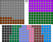
Seats in the Lower House of the Riksdag, 1950-1971
during the Emergency Period

1682810745542.png

Agriculture: 50
Mining: 25
Manufacturing: 25
Consumer Industries: 25
Commerce: 25
Culture: 15
Employees' Organisations: 25
Public Administration: 25
Elected by Local Government: 75
Nominated by Royal Majesty: 50
Total: 340

The Revolution of 1946 brought about a complete overhaul of the Swedish body politic. Though ostensibly launched to defend the social order from "Communist designs", a fear that seemed to have been substantiated when the Rosen Government's backbenchers forced it to commit to major nationalisations and agrarian reforms, its initiators would end up remaking Swedish society in a far more deep-seated and lasting way than their enemies had ever managed.

The new Council of Government, led by Chancery President Johan Adolf Boberg (a civilian, although he had formerly been an Army officer and maintained contacts with the officers who led the coup), was originally intended to be a temporary affair - as these things so often are - however, they were determined to root out the "societal ills" that had created a situation where a coup was "necessary" to begin with. To this end, with the backing of the King (although his exact degree of willingness has been debated by historians), they promulgated several "special ordinances" (särskilda förordningar) over the period from the Revolution in April 1946 until October 1949. The first of these ordered the Riksdag dissolved and empowered the Council to make ordinances with the force of law in its absence, while the second dissolved all existing political parties and enabled the dismissal and ban from politics of any official suspected of "seditious activity". When (strictly non-partisan) local elections in 1947 resulted in several high-profile opposition figures winning local office, an additional ordinance was passed that abolished local democracy in a list of "strategically important" municipalities and empowered the central government to appoint mayors for them. And, of course, the noose continued to be tightened around actual militant opposition to the new order - after a demonstration in Stockholm in spring 1949, sixteen activists and trade union organisers were sentenced to death for insurrection. Five of them were executed, sparking an additional wave of protests and eventually the birth of underground resistance movements.

When, on its fourth anniversary in March 1950, the Council of Government announced that a new Riksdag would be elected the same autumn, many hoped it was the light at the end of the tunnel. However, they would be deceived. The new Riksdag would be completely different from the old one - the old one had consisted of party representatives elected by universal suffrage, both of which the Council's members regarded as evils that had helped bring the spectre of communism into the electorate's heads. Instead, the new election law drew inspiration from the ancient order of the Swedish state, and specifically its system of elections by estate. The old four estates - nobles, clergy, burghers and peasants - were not brought back as such, although the former two orders continued to be represented in the Upper House. Instead, the law listed seven social corporations which would each be entitled to elect a set number of representatives in the Lower House - agriculture (so the farmers technically did form an estate again), mining, manufacturing industries, consumer industries, commercial trades, cultural trades, employees' organisations and public officials. In addition, seventy-five members would be elected by the local government bodies of each county, while another fifty were nominated by the King with the advice and consent of the Council.

Needless to say, although each corporation was theoretically allowed to choose its representatives freely, in practice almost the entire chamber was composed of government supporters. Each corporation had an official organisation run by government allies, which nominated slates of candidates that were elected with only token opposition. The indirectly-elected local government representatives, similarly, were chosen by local bodies that had by this point been thoroughly purged, and every one of its number was on side. Finally, the nominated members included all members of the Council as well as most senior government and military figures, who would be able to control the chamber from within even if the rest of its membership turned out less than reliable. In short, no dissent would enter the Riksdag, and while the new chambers did pass a new constitution, the Instrument of Government 1951, in fairly short order, it was a highly authoritarian document that codified most of what the Council had previously done, as well as giving it sweeping emergency powers. The "Riksdag of the Corporations" would be elected four more times, with five-year intervals, and no major changes were made to its composition in that time. It was only after the scandals surrounding the 1970 elections, the Red Spring and the Revolution of 1971 that free multi-party elections would return to Sweden.
 
Last edited:
Earlier today I found a proposal for county reorganisation in Finland which I thought was interesting and decided to map. With that in mind, here we are.

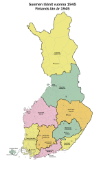
finland-län-1945.png

So in 1945, Finland was essentially still divided into the same counties it had had during the Russian period. The only major changes after independence were the creation of Åland as an autonomous region in 1918, and the division of Oulu county to create Lapland county in 1938. These changes were both on the periphery of Finland, and the counties in the centre of the country remained unchanged. Which was a problem since they were both very large and also of inconsistent size - Mikkeli being a relatively small, coherent economic unit, while Vaasa and Viipuri administered huge swathes of country from central places that weren't always that centrally located. Of course, the war had solved the Viipuri issue, which did however leave the rump - hastily renamed Kymi county and its administration equally hastily moved to temporary offices in Kotka - with somewhat awkward borders that didn't fit its new economic geography.

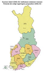
Something clearly needed to be done, and in June 1945, the cabinet of J. K. Paasikivi submitted a proposition to Parliament (1945/43, if anyone wants to look it up) that would reorganise the country from ten into thirteen counties:
- The Laukaa and Viitasaari hundreds were separated from Vaasa county and joined with a few municipalities from neighbouring counties to form the new Central Finland (Keski-Suomi) county, with its seat in Jyväskylä;
- A number of municipalities covering the entire coast of Vaasa county from Kokkola and southward, along with the few inland municipalities that were majority Swedish-speaking, were likewise separated to form the new Korsholm county, whose seat would be in Vaasa despite the fact that that city would remain part of, and the administrative centre of, Vaasa county proper;
- The eastern half, essentially, of Kuopio county was split off to form the new North Karelia (Pohjois-Karjala) county, with its seat in Joensuu;
- Häme county would be shifted northwest to adjust to the fact that it was now economically centred on Tampere rather than Hämeenlinna, with a number of municipalities joining it from Turku-Pori and Vaasa counties while three each were ceded to Turku-Pori and Uusimaa;
- Finally, five municipalities in the northeast corner of Uusimaa would be ceded to Kymi to bring the entire valley around its namesake river into the county.

finland-län-1945-prop.png

The proposal was passed, but its implementation deferred until after the next election due to, well, about twenty other things more pressing to deal with for Finland in 1945. The next parliament seems to have been more lukewarm, or maybe they just had more afterthought, because they voted down the necessary enabling legislation, and so the proposal was scrapped.

In a lot of ways, however, the 1945 plan was ahead of its time. The majority of the proposed changes would in fact come to pass in later years, starting in 1949 when the Uusimaa/Kymi boundary was adjusted in the exact way proposed in 1945. Around the same time, a permanent administrative seat for Kymi county began construction in Kouvola, a town that would have been on the county line had that change not been made. In 1960, Central Finland and North Karelia became separate counties, a move that was long overdue by then, and in the early 1990s, the boundary between Turku-Pori and Häme counties was adjusted to almost, but not quite, follow that proposed in 1945.

The most notable part of the 1945 proposal that would never be implemented was the division of Vaasa county along linguistic lines. It had long been a goal of the Swedish People's Party to create a Swedish-majority county on the Finnish mainland, since bilingual institutions in Finnish-majority areas were seen as insufficiently able to protect the minority language from assimilation. Presumably they were able to get this into the plan while everyone else was too busy debating other things, and I can imagine it was a big part of the reason why the 1945 plan would not survive the next general election. Even ignoring the slightly gerrymandered look of the proposed Korsholm county, it was just frankly weird that Vaasa would've been left part of a county it was not contiguous with, and made into the seat of two separate counties at the same time. Shades of Chandigarh.

Anyway, I suppose I'd be remiss not to mention that, when the counties were abolished "reformed" in 1997, and then abolished for real in 2010, one of the new regions drawn up to replace them followed the boundaries of Korsholm county pretty closely, except that it included Vaasa as well as three Finnish-majority municipalities east of it. This new Österbotten/Pohjanmaa region also formed a welfare service area starting from this year, so in a sense, the old SFP proposal for a Swedish-majority administrative area in Ostrobothnia has in fact been realised. It just took anywhere from 50 to 80 years depending on how you slice it.
 
I've spun the Swedish Finland stuff off into its own thread, since I decided it was taking attention away from the election maps and I have enough stuff on it that I might as well make it into a Thing.
Exciting! Yeah I have to say considering the amount of work that has gone into it over the years, I always wondered if you wouldn’t end up creating a thread.
 
Turkish Senate (composition)
Between 1961 and 1980, uniquely in its history, Turkey had a bicameral parliament. The 1961 military coup, somewhat paradoxically, had been aimed at making Turkey a safe place for democracy by resetting the political process and preventing any one party from amassing near-absolute power in the way the Democrats had over the 1950s (or so the coupmakers believed, anyway). A classic way to do this in constitutions is to create an upper house to serve as a check on the lower house, and such was the intention with the creation of the Senate of the Republic (Cumhuriyet Senatosu) in 1961.

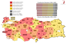
The Senate differed from the National Assembly (the lower house) in a number of key ways. Firstly, while the Assembly was elected all at once to a four-year term, subject to early dissolution, the Senate would be elected to staggered six-year terms, with a third of the membership up for election every two years. This made it similar to the US Senate, but it differed in that the provinces were still represented somewhat according to population, with Istanbul getting ten seats while most provinces had between one and three. The electoral system was FPTP in single-seat provinces and bloc vote in the rest, i.e. the same system that had been used to elect the National Assembly up to this point (although that switched to PR from 1961). The other key difference was that the Senate, in addition to 150 elected members, also included 15 members appointed by the President (kontenjan senatörler, literally "contingent senators"), who were required to be university graduates over 40 years of age who had done some kind of public service for at least six years prior to appointment, as well as a number of ex-officio senators (tabii senatörler, literally "natural senators") which fluctuated, but included all 22 members of the National Unity Committee (MBK), the military junta that ruled Turkey immediately after the coup, as well as former Presidents if they were still alive and able to take their seat. Ismet Inönü declined in order to stand for election to the National Assembly in Malatya, a seat he won handily allowing him to take back control of the CHP faction in the Assembly and become Prime Minister in a grand coalition government, and Celâl Bayar was still in prison, so none of the eligible former presidents actually took their seats.

The first elections to the Senate were held on 15 October 1961, the same day as those to the new National Assembly, and saw all 150 elected seats up for election at once. Once elected, the members (or, more accurately, the provincial delegations) drew lots to determine who would serve terms of six, four and two years, with these forming the A, B and C groups within the Senate respectively.

val-tr-sen.png
 
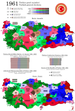
Turkey 1961
Here's the 1961 elections on a reworked basemap, which should both be more accurate than the old one and also allow me to do district-level maps if and when the fancy strikes. Note also the actually correct provincial boundaries in the southeast - I used to have Siirt include all of today's Şırnak province, which was in fact created out of parts of all three provinces that border it.

So this is of course the first election held after the 1960 military coup, which overthrew the Democrat Party government of President Celâl Bayar and Prime Minister Adnan Menderes. The Democrats had first come to power in 1950, defeating the CHP (Turkey's only legal party until 1946) in the second-ever direct election to the National Assembly. At the time, the electoral system used was bloc vote by province, which allowed the winning party in a given province to make a clean sweep of the seats in almost every case. This, in turn, meant that the winning party on a national level was often able to secure a very wide majority in the unicameral parliament, and by extension close to absolute power. The Democrats were quick to make use of this, fundamentally reshaping the country in a number of ways during their ten years in power. They accepted Marshall Aid and joined NATO, they privatised a number of key state industries built up under Atatürk and his successors, and when Turkey failed to partake of the general economic boom times of the 1950s, they began to threaten opposition politicians and journalists and incited massive pogroms against Istanbul's Greek population in September 1955. In short, Democrat rule turned out to have all the downsides of the CHP era with none of the perceived benefits in terms of national pride and development.

In 1957, the opposition parties attempted to band together to oust the Democrats, but in response to this, the electoral law was modified to prevent the formation of such an alliance - candidates were prohibited from standing for election under a party of which they were not a member, and all parties standing for election were required to present a full list of candidates in each constituency where they stood. The result was that, despite winning only 48% of the popular vote (a loss of nearly ten percentage points compared to the previous election in 1954), the Democrats captured over two thirds of the assembly. Ironically, it seemed as though the Democrat Party was on the verge of abolishing Turkish democracy, and these fears only became more real over the next couple of years as opposition politicians faced harassment by Democrat supporters and then by the state itself. In April 1960, the National Assembly passed a law authorising a Committee of Inquest, a parliamentary committee with no opposition representation which would have broad power to investigate alleged plots against the government and to issue legal rulings as if it were a court. This immediately met with mass protests led by students and academics in Istanbul and Ankara, which resulted in two deaths and dozens of injuries as protesters clashed with the police.

Matters were coming to a head, and over the course of May, a group of young officers around Colonel Alparslan Türkeş (who was previously best known as the defendant in a 1944 trial where he stood accused of hate speech and furthering pan-Turkist plots and was sentenced to nine months in prison) decided they might as well be the ones to save democracy if no one else would. After securing promises of support from a few key generals (though notably not the ones in overall command), they formed a junta called the Committee of National Unity (Milli Birlik Komitesi, MBK). On 27 May, troops marched out into the streets of Ankara, and Türkeş issued a statement over the radio declaring martial law throughout the country and calling on all patriotic citizens to "assist in re-establishing the democratic régime the nation desires". The leaders of the Democrat government, including Bayar and Menderes, were arrested and taken to holding cells on the island of Yassıada, one of the Princes' Islands south of Istanbul. There, they would be held for over a year, with some getting tortured and most treated very harshly - Turkish prisons do have a certain reputation. In October, the state brought charges against 592 people associated with the Democrat government, including Bayar and Menderes. The prosecution initially called for the death penalty in 228 of these cases, but at the end of the process, only fifteen people were actually sentenced to death - one of them, former President Bayar, saw his sentence commuted to life in prison because of his advanced age, and would in fact go free in 1966 as part of a general amnesty, only dying in 1986 at the age of 103. Menderes, however, was not so lucky - he had already faced the gallows by the time the 1961 general election was called.

By then, the MBK had already suffered a major split. As the coup took form, the military leadership was more or less roped into supporting it, and recently-suspended Army Commander General Cemal Gürsel was woken up, flown to headquarters from his Mediterranean retreat and proclaimed leader of the provisional government all while still in his pyjamas. Gürsel was a lifelong military man and a real father to his men, and him taking charge of the coup no doubt helped it maintain cohesion, but there was one big catch: he was a known and longstanding opponent of military interference with politics. In fact, just weeks before, he'd written a farewell letter to the army urging them to "stay away from politics at all costs. This is of utmost importance to your honour, the army's might and the future of the country." Although he had been forced into retirement for gently pushing against President Bayar, and his having come up during Atatürk's final years meant that he was seen as a CHP-leaning figure more or less by default, he does seem to have been quite genuine in believing that the army's role after the coup really was just to reset the democratic order and then hand power to an elected civilian government. This brought him into conflict with a younger clique of officers around Türkeş, who believed they ought to take this opportunity to really reshape Turkish society from the ground up (i.e. establish a fascist dictatorship). This faction suffered a setback in July 1961, when a very liberal new constitution was approved by an imposing yet believable 62% of voters in a national referendum, and in September, just as the nation prepared to go to the polls, 14 of the 38 members of the MBK were expelled and sent off to distant posts, mostly as military attachés at embassies far from Ankara.

I talked about some of the constitutional innovations of 1961 in the previous post, so just to briefly recap: while Turkey would remain a parliamentary republic with a very powerful legislative branch and a government responsible to it, the new parliament was structured in such a way as to make one-party rule, if not impossible, then at least harder to attain without genuine popular support. The National Assembly, which was reduced in size from 610 to 450 seats, would now be elected by proportional representation, preventing the easy landslides seen in previous elections. To prevent a lot of small parties or (horror of horrors) ethnic minorities from being elected, the electoral law required a party to have an organisation in at least fifteen provinces to stand for election. Meanwhile, a new Senate was created with 150 elected seats which were renewed gradually with a third up for election every two years, in addition to which the members of the MBK were entitled to sit in the Senate by right, while the President could appoint another fifteen prominent figures from outside politics to sit in the upper house.

The elections were, at long last, held on 15 October, with the entire country electing members to both houses. The early favourites to win were the Republican People's Party (Cumhuriyet Halk Partisi, CHP), who had after all run the government for the entire time up to 1950 and been the main opposition since then. It simply stood to reason that with the Democrats gone, it fell to the CHP to run the country again. However, in their ten years in power, the Democrats had built a formidable political machine, and that wasn't about to go away just because its figureheads had been shown the noose. It simply created a power vacuum waiting for someone to fill it, and that someone did. Ragıp Gümüşpala, the commander of the Third Army during the coup and the most senior general to oppose it openly (his threats against the coupmakers were a key factor behind the decision to bring Gürsel out of retirement), founded the Justice Party (Adalet Partisi, AP) in February 1961, more or less openly as a successor organisation to the Democrat Party. The AP would even adopt the white steed Kırat, a symbol of freedom and justice from Turkish folklore that had been chosen as the symbol of the Democrats because Demokrat sounded a bit like Demir Kırat ("Iron Kırat"), as its own logotype. A less obvious continuity organisation, the New Turkey Party (Yeni Türkiye Partisi, YTP - cue air horns) of former Finance Minister Ekrem Alican, was also quite successful in taking over Democrat votes, especially in eastern Turkey. Finally, the system was rounded out by the succinctly-named Republican Peasant Nation Party (Cumhuriyetçi Köylü Millet Partisi, CKMP) of Osman Bölükbaşı, which was a far-right nationalist and pan-Turkist outfit whose antecedents had existed since the early 50s and which drew much of its strength from the countryside immediately east of Ankara.

The campaign was quite sedate, if only because the MBK had made sure it would be that way by preventing the main parties from openly criticising it or embracing the legacy of the Democrat government. There wasn't actually that much poll movement between 1957 and 1961, if you ignore the fact that the Democrat Party had been forcibly dissolved and split into two new parties - the CHP actually ended up losing a few percentage points in the popular vote, but the new electoral system meant they still gained a bunch of seats and became the largest party in the new assembly. The AP wasn't far behind, however, and between it and the YTP, there was a near-majority (223 seats) for the Democrats' heirs, leading to the quip that Menderes had won the election from beyond the grave. Still, Gürsel was not going to allow for the new government to be the exact same as the old one, so he invited İsmet İnönü, as the leader of the largest party in the lower house, to form a government - his eighth. The formula he settled on was a grand coalition with the AP, with Gümüşpala staying out of the cabinet but supporting it from the outside, while ministerial portfolios were divided about equally between the two parties.

An interesting quick I'd be remiss not to mention, by the way, was that the CHP seems to have derived most of its strength from being in second place across most of the country - which makes sense given how the other parties took over sections of the old Democrat machine, which were each dominant in their respective regions. However, this did them no favours in the Senate elections, which were still held under the old bloc vote system. As a result, although the CHP topped the polls across the country on both ballots, the AP ended up getting almost twice as many seats in the Senate, while the YTP also almost equalled the CHP's seat count. This was not to last, however, at least not in the latter case.

val-tr-1961.png
 
The ride goes on. I'm hoping to finish the map today, remains to be seen whether I can get the writeups done as well.

Finland Proper (18 constituencies, quota 20,911)

60: Turku Cathedral (Turun tuomiokirkko, Åbo domkyrka)
24,065 (+3,154)

I've had a casual look at Turku's ecclesiastical division while drawing these constituencies, and although I've ignored the parish boundaries in a lot of cases, it still felt right to name this seat, which covers the city centre east of the Aura river as well as the university area, after Finland's primate church. As a student-heavy area, it's generally pretty strong for the combined left, but its left-wing vote was heavily split between Left and SDP in this election, and as a result the seat went to the Coalition.

61: Turku-Mikael (Åbo-Mikaels)
18,698 (-2,213)

Another seat named for a church, although in this case I believe the majority of the constituency is actually in the cathedral parish. This is the commercial centre of the city, but the newer side, having mostly been built during the Russian period and after the 1827 fire. Its politics aren't much to write home about, you should know the drill by now - safe Coalition. My guess is that Petteri Orpo would represent either this seat or #64, since he's not from anywhere in the city originally and those are the safest Coalition seats in it.

62: Turku-Maaria (Åbo-Marie)
21,025 (+114)

Maaria used to be one of the two rural parishes covering the area around Turku, along with Kaarina south of the river. Today, it's thoroughly suburbanised and somewhat politically mixed, although mostly lower-middle class, which along with the presence of the Runosmäki estate means it's a good seat for the SDP specifically.

63: Turku West (Länsi-Turku, Åbo västra)
19,893 (-1,018)

I wasn't able to settle on a good name for this seat, as it covers part of the Maaria and Mikael parishes, both of which have their seats in other constituencies, and no one suburb really seems dominant - though there is a commercial area called Länsikeskus (West Centre), so with that in mind I think just calling it Turku West is acceptable. This part of the city is mostly working-class and was built to house workers for the shipyard, which is now located in Perno at the western edge of the constituency. The shipbuilders used to be a solid Communist constituency, and the Left remains quite strong here, but as with #60, vote splitting (and the Finns presence) is strong enough to hand it to the Coalition.

64: Turku Harbour (Turun satama, Åbo hamn)
23,664 (+2,753)

Although this seat includes the western edge of the city centre, its main focus is the islands along the coast, which are thoroughly middle-class and vote for the Coalition by wide margins. The mainland part of the seat is more akin to #60 in its politics, with a formerly-strong Green presence that's given way to vote splitting and a narrow Coalition plurality. Still a blue seat, in other words.

65: Turku-Henrikki (Åbo-Henriks)
19,461 (-1,450)

A largely middle-class seat made up of suburbs built after the war in what was formerly Kaarina municipality, annexed into the city in 1939. While not as safe as #64, all of the areas here tend to vote Coalition, so they'll likely win the seat handily.

66: Turku-Varissuo (Åbo-Kråkkärret)
19,079 (-1,832)

Varissuo, literally "Crow's Moor", is Turku's most infamous housing estate, built in the 1970s and largely housing working-class people of all ethnic backgrounds. Unlike the older working-class neighbourhoods and the university area, Varissuo and its surroundings seem to have always voted SDP, and the seat remains their safest in the city.

67: Raisio (Reso)
26,109 (+5,198)

Turku added up to a bit more than seven seats, so the solution I went with was to combine its (very rural) northern extremity with some of the suburban municipalities nearby, resulting in this apparently oversized seat. You'll eventually see why there was a surplus that needed to be distributed, though perhaps there could've been a more elegant solution than this. Either way, Raisio proper is similar to the areas of Turku across the border from it (seat #63), having started out as overspill housing for harbour and shipyard workers, and as such used to be solidly left-wing. Since 2011, though, the Finns have made strides here, which combined with the Centre collapse taking out their stronghold in the north of the seat has meant that this is a somewhat safe yellow seat in 2023.

68: Naantali (Nådendal)
20,062 (-849)

Naantali, a medieval town that originally hosted a nunnery (the Swedish name "Nådendal" literally means "valley of grace"), but is now primarily known as a summer place, being host to the President's country residence at Kultaranta as well as the Moominworld theme park. A lot of the permanent population commutes to Turku, and their voting lean is similar to that of the islands in Turku proper - Naantali has always been a Coalition-voting town, and 2023 is no exception.

69(nice): Mynämäki (Virmo)
20,732 (-179)

This is a mostly-rural seat made up of a number of small villages along the coast and the road between Turku and Pori. Traditionally would've been a Centre stronghold, now it's a Finns stronghold instead.

70: Uusikaupunki (Nystad)
19,711 (-1,200)

Uusikaupunki ("new town") has been home to a car factory run by Valmet since the 1960s, and a number of other industries remain present in the town. It still seems to slot neatly into the "post-industrial regional town" mould, going from an SDP stronghold to one for the Finns over the 2010s.

71: Loimaa
19,617 (-1,294)

This seat covers the entire interior of Finland Proper, an area that was mostly considered part of Satakunta until the 20th century. Loimaa itself is home to the Finnish Agricultural Museum, which should tell you all you need to know about its former political leanings, but today it's a reasonably safe Finns seat.

72: Lieto (Lundo)
21,806 (+895)

This is a mixed seat that stretches from Turku's suburbs up to the border with Häme. Although Lieto proper (the closest area to Turku) voted for the Coalition, the rest of the seat was quite weak for them, and I believe this would be enough to let the Finns come out on top, although it would likely be a close race.

73: Kaarina (S:t Karins)
21,719 (+808)

The aforementioned municipality of Kaarina, which used to cover a good chunk of what's now Turku as well, is thoroughly suburban and middle-class, and as a result votes for the Coalition by a decent enough margin.

74: Paimio (Pemar)
23,307 (+2,396)

Another "small towns along the coast" seat, which is mostly situated along the railway line between Turku and Helsinki - although every single station in the constituency is closed, Finland outside Helsinki being a bit behind on the regional rail revival. The area doesn't seem to suffer too badly though, as most of it voted for the Coalition.

75: Salo
20,906 (-5)

Salo is probably best known for the Nokia mobile phone factory, which was located here from 1979 until 2015, when production was offshored. There's still a substantial high-tech industry in the town, though, just not the manufacturing side. The closure still hit the town hard, as most of the workers weren't exactly in a position to get computer science degrees, and unemployment continues to be high leading to a strong Finns presence. The town proper, however, voted for the SDP by a decent margin in 2023.

76: Somero-Perniö
19,286 (-1,625)

This seat combines the municipality of Somero with Salo's rural fringe, and resembles #71 politically: a formerly safe area for the Centre, which now votes for the Finns by a good margin.

77: Åboland (Turunmaa)
17,255 (-3,656)

Remember how I mentioned that there was always going to be a surplus? This is why. The two Swedish-speaking municipalities in the Åboland archipelago, Pargas and Kimitoön, are almost big enough for a seat when combined, but there's not really any one area that would be suitable to combine them with. I decided it'd make more sense to leave them aside, with the same justification as for the Österbotten seats. It's a reasonably safe SFP seat, although not quite as safe as those.

Satakunta (8 constituencies, quota 21,225)

78: Pori Central (Keski-Pori, Björneborg centrala)
22,516 (+1,291)

Pori is a kind of poster child for post-industrial malaise in Finland: it was traditionally a manufacturing and textile town, and in the 1960s turned down the offer of a university campus because it was felt that the local industries provided sufficient economic opportunity without the need for one. Cue the 90s, and unemployment in the city hit 25%. Recovery has been slow and painful, and the city is smaller today than it was in 1975. Not surprisingly, the Finns have done very well here for most of their history, although the formerly-dominant SDP is still a strong factor in local politics. Enough so, most likely, to win the central seat, although the Coalition also has a presence here and I honestly couldn't say for sure who is stronger.

79: Pori West (Länsi-Pori, Björneborg västra)
20,857 (-368)

Aside from the central seat, I've divided Pori roughly along the Kokemäki river, which seems to provide a neat enough split. The west bank of the river was the seat of many of the aforementioned heavy industries, and most of the residential areas here are working-class - then again, that's true of most of the city. Likely a safe-ish SDP seat in the past, today it's reasonably good for the Finns.

80: Pori East (Itä-Pori, Björneborg östra)
22,183 (+958)

Again, Pori doesn't seem to have a huge geographic divide within it, but if anything it seems like the east of the city is slightly more middle-class. Doesn't matter too much though, as this seat is also a safe Finns one.

81: Northern Satakunta (Pohjois-Satakunta)
19,899 (-1,326)

Yet another rural seat that used to vote Centre and now votes Finns. The biggest settlement in the seat is Kankaanpää, which by all accounts was an early Finns stronghold, and the entire thing voted for them by imposing margins in 2023.

82: Rauma
21,131 (-94)

Rauma is an old port town with a strong (though nearly extinct) local dialect, and it still has a strong industrial presence mainly centred around the harbour and the UPM-Kymmene paper mill. Unlike most other such places, the SDP still dominates here, although part of that may be that they had further to fall - it used to be their single biggest stronghold in Finland alongside Varkaus (also a paper mill town - coincidence?).

83: Eura
21,812 (+587)

This seat includes bits of Rauma as well as its namesake municipality, both of which are still SDP strongholds.

84: Ulvila (Ulvsby)
21,157 (-68)

Ulvila was formerly one of Finland's six medieval market towns, but when the harbour silted up as a result of post-glacial rebound, Pori was founded further downriver to replace it. Ulvila has since become a suburb of Pori, and does sort of alright as a result, but not great given the city it's next to. Although Eurajoki (the coastal part of the seat, most notable as the home of Olkiluoto nuclear power station) voted SDP, the rest went for the Finns by enough of a margin to carry the seat.

85: Kokemäki (Kumo)
20,246 (-979)

This seat actually has three roughly-equal population centres, Kokemäki itself, Harjavalta and Huittinen, all of which are former industrial towns along the Kokemäki river. None of them are doing that hot, and a former SDP-Centre swing seat is now a safe Finns one.

Landskapet Åland (Ahvenanmaan maakunta) (1 constituency, electorate 21,557)

86: Åland (Ahvenanmaa)

Åland is, of course, special. Luckily for us, its electorate is almost exactly right for one seat, which is likely contested by an entirely different set of parties from the mainland ones. If the situation is anything like OTL, however, there'll be a dominant bloc of centre-right parties which nominates a unity candidate who then sits with the SFP once elected. As such, although the seat is marked independent grey on the map, I'm counting it as an SFP seat for the purposes of the total.

Regional subtotal

Finns 11
Coalition 8
SDP 6

SFP 1+1

National total (thus far)

Coalition 46
Finns 36
SDP 35
Centre 19
SFP 11+1
Left 2
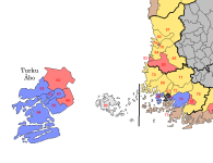

1684496995865.png
 
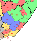
I had this done as well. I'm not 100% happy with it, although I also suspect there's no alternative that would leave me 100% happy, so I may as well call it done and write it up.

Southeast Finland (16 constituencies, quota 21,155)

121: Kouvola
24,356 (+3,201)

A railway town that connects essentially the whole of eastern Finland's rail network, Kouvola is probably most famous for being extremely ugly, its grey-concrete city centre giving it the nickname Kouvostoliitto (a portmanteau of Kouvola and Neuvostoliitto, the Finnish name for the Soviet Union). Politically, although surrounded by a number of heavily industrialised areas, it seems always to have voted for the Coalition, in what I assume is a similar dynamic as with Seinäjoki.

122: Kuusankoski
21,976 (+821)

Kuusankoski is one of those aforementioned industrial towns surrounding Kouvola, being home to one of Finland's biggest pulp and paper mills, and largely votes SDP just like other such towns across Finland. However, the seat also includes the former municipalities of Jaala and Valkeala, both of which tend to vote for the Finns, and the SDP's margin in Kuusankoski proper is not enough to offset this.

123: Anjalankoski
18,686 (-2,469)

The last of three seats covering the municipality of Kouvola, Anjalankoski is also industrialised, and unlike Kuusankoski there's not enough rural areas in the constituency to overcome this.

124: Kotka
23,037 (+1,882)

Kotka is one of Finland's newer major cities, having been founded in 1879 to provide a harbour at the mouth of the Kymi river. It remains a largely industrial city to this day, and the continued importance of the Kymi river as a shipping link from eastern Finland to the sea means it hasn't suffered as badly from deindustrialisation as some other places (*cough*Pori*cough*). As such, it keeps voting SDP, having been a stronghold for the party for a very long time.

125: Kymi-Pyhtää (Kymmene-Pyttis)
21,513 (+358)

Kymi municipality, which has the majority of this seat's population, was amalgamated into Kotka in the 70s, but Pyhtää remains independent to this day. It's usually cited as the easternmost outpost of the Swedish language in Finland, although I'm unsure if it's ever been majority Swedish-speaking. Either way, it's nowhere near enough to affect the seat's political makeup, which comes out with a plurality for the Finns due to some lingering malaise in the suburbs of Kotka.

126: Hamina (Fredrikshamn)
20,741 (-414)

Once an important harbour and fortress city, Hamina lost most of its importance by the 19th century due to moving borders and post-glacial rebound, and Kotka has supplanted its role as southeast Finland's main harbour (although recent development may be changing that). What remains is a somewhat sleepy military town that was an early stronghold for the Finns.

127: West Karelia (Länsi-Karjala, Västra Karelen)
23,553 (+2,398)

This deceptively-awkward seat includes a big chunk of rural land around the southwestern shores of the Saimaa along with some of Lappeenranta's western suburbs. The rural areas are about evenly split between Centre and Finns, and as a result, the Coalition comes out on top across the seat.

128: Lappeenranta (Villmanstrand)
23,472 (+2,317)

Lappeenranta is an old military and inland harbour town, though today its major source of income is tourism, particularly across the border from Russia (until last year, that is). This seat includes most of its central areas, and while likely closely fought between the SDP and Coalition, I've put the SDP out on top.

129: Lauritsala
21,757 (+602)

This seat mainly consists of the former municipalities of Lauritsala and Lappee, which were both merged into Lappeenranta in 1967, and Joutseno, which followed suit in 2009. Most of it is made up of industry utilising the transport connections across the lake, and most of it votes for the SDP.

130: Imatra
20,590 (-565)

Imatra is one of those handy (although not so handy, see #131 for more on that) municipalities that are the exact right size to make up a constituency by themselves. It's situated at the rapids where the Vuoksi river flows out of the Saimaa, and those rapids have powered a lot of industrial production over the years. Again, a safe SDP seat.

131: Saimaa East (Itä-Saimaa, Östra Saimen)
17,713 (-3,442)

This seat is a large part of why I don't like how this region ended up. The part of South Karelia north of Imatra is simply nowhere near big enough for a seat, and there's nowhere that naturally connects to it either. With Savonlinna not big enough for two seats on its own, this is how things ended up. I don't endorse it, but nor do I see a viable alternative that doesn't mean cutting a bunch of other natural communities in half.

132: Pieksämäki
20,059 (-1,096)

Pieksämäki is another railway town, although a substantially quieter one than Kouvola, with its branch lines not seeing much passenger service anymore. The municipality itself voted narrowly for the Finns in 2023, although the town itself voted SDP, as did neighbouring Kangasniemi in enough numbers to (I believe) tip the seat.

133: Mäntyharju
19,410 (-1,745)

This is an essentially rural seat that covers the southwestern corner of the former Mikkeli Province, and like most rural areas would've traditionally voted Centre. In 2023, however, they did badly enough that the Coalition came out on top.

134: Mikkeli (S:t Michel)
19,540 (-1,615)

Mikkeli is one of those towns whose historical importance outweigh their size, with both a cathedral and (historically) a county residence present, and it remains somewhat prosperous for its size. Historically the SDP have done quite well here, but in recent years it's tended to vote for the Coalition.

135: Juva
21,193 (+38)

Another catch-all rural seat, this time covering everything between Mikkeli and Savonlinna. Actually voted for the Centre.

136: Savonlinna (Nyslott)
20,883 (-272)

Savonlinna is located on an island in the middle of a strait in the Saimaa, and this made it a key strategic point for a very long time, being demanded by Russia in the 1743 peace and serving as their main stronghold in the region until 1809 came along and made it redundant. Its life continued as a transport hub, with a railway built crossing the strait and allowing for transshipment between boats and trains, and like Mikkeli it remains a prosperous town with a strong tourist industry. Movement Now have become weirdly strong here, probably due to local community leaders defecting from the Coalition, but it wasn't enough to dislodge the SDP. Thank God, as it means I won't have to add another colour.

Regional subtotal

SDP 7
Coalition 4
Finns 3
Centre 2


National total (thus far)

Coalition 50
SDP 42
Finns 39
Centre 21
SFP 11+1
Left 2


1684497711999.png
 
A quickie based on something I found on German Wikipedia while reading about, of all things, Giorgio Moroder's old recording studio in Bogenhausen.

By the time of the Second World War, Munich was fast outgrowing its own transport network. The tram system, which had served the city for over half a century by this point, was badly overcrowded, and while new suburban extensions kept getting built and grandiose plans drawn up, it was becoming clear that something more heavy-duty would be needed to handle the kind of passenger flows expected to travel between city and suburbs in the future. The Nazis had intended to build a large network of underground railways in the city, which they regarded with special fondness as the Hauptstadt der Bewegung ("capital of the movement") where the party had been founded and many of the key events of its early history took place, and the first step in this process was a tunnel under Lindwurmstraße, the main axis running southwest from Sendlinger Tor in the city centre, which started construction in 1938. Of course, with the beginning of the war, Germany found itself with higher priorities and work had to be abandoned, but there remained a finished cut-and-cover trench with room for track and stations when the new democratically-elected masters took over the city in 1946.

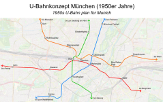
What to do with this tunnel, and indeed the city's rail network more broadly, would become a prominent theme of Munich's city politics for a long time after the war. One of the early plans, presented by the city's urban planning commission sometime around 1955, foresaw four new U-Bahn lines, two running broadly north-south and another two east-west, which would form a web of interchanges in the centre of the city and connect all eight suburban sectors identified by the planners.
- Line A (red on the map) would follow a straightforward east-west alignment connecting the city's two main railway stations, with stops in between at the Stachus and Marienplatz, where connections could be made to all the other lines, and would connect Pasing in the west with Berg am Laim in the east.
- Line B (orange) would run parallel to line A but to the north, dipping south to provide a close-ish connection at the Stachus (I don't understand why they drew it this way rather than having the lines intersect there, I'd guess capacity differentials if only because that's always a good guess when rail lines do things that don't look logical on the map).
- Line C (blue) would utilise the Lindwurmstraße tunnel to run southwest-northeast through the very heart of the city at Marienplatz, also providing connections to line B at Odeonsplatz and to line D at Goetheplatz, connecting Freimann in the north to the Waldfriedhof in the southwest.
- Line D, finally, would run from the Siedlung am Hart in the north of the city, through the Maxvorstadt down to the Hauptbahnhof (no connection was specified to any other line, though I have to assume there would be stations nearby for lines A and B, if only because it would be monumentally stupid to run past the Hbf without stopping there - alternatively, the Hbf and Stachus stations might've been intended to form a single complex), then south to Goetheplatz to connect with line C before crossing the river into Giesing.

The city council balked at the projected cost of this plan, and asked the planners to instead focus their energies on a system of tram tunnels like the ones being built or planned in cities like Cologne, Frankfurt and Stuttgart around the same time. I believe that would've run along corridors similar to these ones, although with only the central parts underground obviously. However, with growing car traffic becoming an issue through the 50s and early 60s, and Munich preparing to bid for the 1972 Summer Olympics, the city fathers changed their minds again, and with promises of generous financing from the state government, finally decided in 1964 to build a full U-Bahn, with line C from the original proposal as the first to be built (it was, after all, already started) and three more core routes eventually to be built, branching into eight separate services to serve all the city's suburbs. In the end, only three core routes would be built for the U-Bahn, although the S-Bahn tunnel opened in 1972 followed the A line corridor to a substantial degree. The U6, which opened in 1971 as Munich's first U-Bahn line, follows the C line corridor more or less exactly, but although line B is parallelled in both of its outer parts by existing lines, neither line B nor D was ever built as originally planned.

munchen-ubahn-1950.png

(might as well tag @iainbhx here)
 
I legitimately don't know if this is a surprising rabbithole at this point, but there is more where this came from.
The thing that surprises me is a) remembering just how dominated by Manhattan New York City used to be and b) that even right after the Civil War the Democrats were still overwhelmingly the majority there. Presumably that was just Tammany Hall doing its thing though.
 
The thing that surprises me is a) remembering just how dominated by Manhattan New York City used to be and b) that even right after the Civil War the Democrats were still overwhelmingly the majority there. Presumably that was just Tammany Hall doing its thing though.
New York City has pretty much always voted overwhelmingly for the Democrats, as long as the party has existed. We’re going to see that more and more as we go on.

Also, of course, NYC was Manhattan at the time - Brooklyn was its own thing with its own political identity, although obviously the two cities were closely intertwined economically, and the rest of it was fields.
 
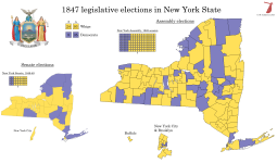
New York 1847
Sometime in the 1810s, New York overtook Virginia to become the most populous state in the United States, a position it would retain until being overtaken by California in the early 1960s. New York's growth in this era was predominantly caused by two factors: the development of New York City as North America's primary harbour, and the rapid and dense settlement of western and central New York largely by population overspill from the New England states, whose meagre farmland was unable to support its growing population. Both of these had been made possible by the construction of the Erie Canal, the biggest public works project of its generation, which created a navigable seaway from the east coast to the Great Lakes for the first time. The agricultural and industrial products of the Midwest, rather than going down the great rivers to New Orleans, now increasingly moved through New York, and this created a huge industrial boom in the state which in turn led to great demand for labour. It's at this time that New York became known as the "Empire State", and it was these historic forces that would lead New York City to become the world's largest metropolis in a few decades' time.

At the same time, however, New York's political and economic structures were falling behind the times. In the Hudson Valley, most good farmland was still owned by a few old Dutch and English families, whose rights to the land had once extended as far as feudal jurisdiction (what was known as the patroon system). The Revolution had led to a reduction in the power of the patroons, but their influence still reached far and wide, and for most small farmers in the region, the norm was to lease one's land from a patroon rather than own it outright as per the Jeffersonian ideal. Matters came to a head in January 1839 on the death of Stephen Van Rensselaer, considered the last of the great patroons in the Albany region (the manor of Rensselaerswyck), who had made himself popular with his tenants by offering them low rents and being extremely forgiving of late payment. When he died, however, his estate was in financial trouble owing to the Panic of 1837, and his heirs were significantly less willing to tolerate delinquent rents. This understandably became a sticking point with the tenants, and was made even worse by the general tradition that debts owed to one's patroon would be forgiven on the patroon's death. Where the tenant farmers of Rensselaerswyck expected to be rid of a financial obligation, instead they now faced collection agents who refused to take no for an answer. On the Fourth of July, a mass meeting was held on the Helderberg plateau, west of Albany, which issued a declaration stating that they would "take up the ball of the Revolution where our fathers stopped it" and secure freedom for the common people by any means necessary. There followed a few years of low-level violence and confrontations with law enforcement, never quite evolving into a proper rebellion but also never dying down, which has become known to history as the Anti-Rent War.

The political establishment was quite unsure of how to deal with the anti-rent movement - on the one hand, property rights were one of the chief principles of the American state, but on the other hand, pretty much everyone recognised that a tenant farmer rebellion was very far out of line with their ideals and made them look downright British. A number of governors (New York's governor served a two-year term at this time) came and went and proposed differing solutions to the crisis, in general starting with benevolent reform proposals that then got buried by the legislature or were overtaken by other matters and ending up discrediting themselves by being forced to call out the militia against the tenants. This pattern was only broken with the election of Silas Wright in 1844, who was openly aligned with the patroons from the beginning. This led to a series of riots through 1845 that were all put down violently, breaking the anti-renters as an insurgent force, but scandalising popular opinion and causing a new groundswell of support for their goals. As a result, not only did Wright lose re-election in 1846, momentum against the established order was strong enough to convene a constitutional convention.

The 1846 Constitution, along with reforming the state's tenancy laws in such a way as to force the dissolution of the feudal manors, also reformed the state's political system along thoroughly Jacksonian lines. The courts were reorganised to abolish colonial holdovers and create more straightforward jurisdictional divisions, and as an anti-corruption measure, all the state officials that had previously been elected by the legislature were now to be elected directly by the people. This included the core of the state cabinet, which weirdly were elected in gubernatorial off-years, as well as the three Erie Canal Commissioners and the three Inspectors of State Prisons, who were to be elected in staggered three-year terms with one seat up for election each year. In addition, the legislature was changed over from the previous multi-member districts (the Assembly was elected by county, while the Senate was elected from larger divisions) to a system of pure first-past-the-post elections, quite possibly the first such case in the US - certainly an early one. The Senate would now be elected from divisions of the entire state, while each county (aside from Hamilton, which consisted - and still consists - largely of uninhabited forest in the Adirondacks) would continue to be allowed at least one assemblyman each, with the rest distributed according to population. The change from the previous constitution being that, rather than larger counties electing their delegations at-large via bloc vote, they would now be required to draw single-member districts that would be contiguous, compact and roughly equal in population. Obviously, this was not as strict as it would be today, but it was still a major step towards the current electoral system used in virtually every US state.

By the time of the first elections under the new constitution, the 1847 midterms, the New York Democrats were in freefall. Wright's tenure as governor, and his controversial renomination in 1846, had created two strong factions within the party, and these were further animated by the Wilmot Proviso (the proposal to ban slavery in all territories gained from Mexico) and the growing conflict over the institution of slavery. On the one hand were the radical faction known as the "Barnburners", who supported decisive action against landlords and banks to root out their abuses, and were thus likened to a farmer who deals with a rat-infested barn by burning it to the ground. The other side, dubbed the "Hunkers", consisted essentially of Wright's faction, although Wright himself died in 1847 before he could really participate in the factional conflict, and supported economic institutions and public works while opposing public debate over slavery. The 1847 party convention was dominated by the Hunker side, and the Barnburners withdrew from it in protest, refusing to support the nominated candidates. There was discussion of proposing a separate Barnburner ticket of candidates, but this ultimately did not come to pass, and some of them ended up supporting the Whig candidates.

The result was a blowout victory for the Whigs, who won all statewide offices up for election and two-thirds majorities in both houses of the legislature. The Anti-Rent movement, thinking its time had come with the new more democratic constitution, nominated their own candidate for Lieutenant Governor, who got a few thousand votes and came a distant third, but several of their preferred candidates in other races won office, including Comptroller Millard Fillmore and Attorney General Ambrose Jordan. All these were Whigs, which feels significant and probably indicates that their power as a movement was on the wane by this point.

val-us-ny-1847.png
 
. . .a system of pure first-past-the-post elections, quite possibly the first such case in the US - certainly an early one.
Several states had pure FPTP senates (with New Hampshire, Alabama, and Virginia specifically having senate districts as opposed to just using the counties), while Vermont's formerly-unicameral state house was comprised of single-member districts up until 1966. That said, I can't think of any state before New York that had two single-member FPTP houses.
 
Back
Top