Also, it seems that the Austrian electoral laws might not be as well preserved as some of the others, because verfassungen.de doesn't even provide links. Which is a terrible shame, because, for obvious reasons, those would've been some of the most interesting parts to map.
-
Hi Guest!
The costs of running this forum are covered by Sea Lion Press. If you'd like to help support the company and the forum, visit patreon.com/sealionpress -
Thank you to everyone who reached out with concern about the upcoming UK legislation which requires online communities to be compliant regarding illegal content. As a result of hard work and research by members of this community (chiefly iainbhx) and other members of communities UK-wide, the decision has been taken that the Sea Lion Press Forum will continue to operate. For more information, please see this thread.
You are using an out of date browser. It may not display this or other websites correctly.
You should upgrade or use an alternative browser.
You should upgrade or use an alternative browser.
Max's election maps and assorted others
- Thread starter Ares96
- Start date
prime-minister
Average electoral map enjoyer
- Location
- Cambridge
- Pronouns
- They/them
And considering it elected a delegate from the 'left in white tie' faction apparently little has changed about its politics since 1848.Little Lichtenstein sending its own delegate
And considering it elected a delegate from the 'left in white tie' faction apparently little has changed about its politics since 1848.
It has politics?
Seriously @Ares96 you know the cadastral maps are gonna get involved with the Austrian and especially the Bohemian boundaries.
I've only ever seen the six seats of Berlin (1867) represented anywhere as a wheel, which is probably to disguise just how small Berlin I was as it consisted of Alt-Berlin, Cölln (Spreeinsel), Freidrichswerder, Dorotheenstadt and the northern teil of the Friedrichstadt which I think is those parts north of Leipzigstraße.
Last edited:
Don't remind me, I've still got shell shock from trying to figure out the 1907 seats for Bohemia. A lot of the Czech-majority seats boycotted the elections in 1848, but that doesn't really help me in any meaningful sense.Seriously @Ares96 you know the cadastral maps are gonna get involved with the Austrian and especially the Bohemian boundaries.
I've been able to make a rough estimation of those seats before, they looked something like this:I've only ever seen the six seats of Berlin (1867) represented anywhere as a wheel, which is probably to disguise just how small Berlin I was as it consisted of Alt-Berlin, Cölln (Spreeinsel), Freidrichswerder, Dorotheenstadt and the northern teil of the Friedrichstadt which I think is those parts north of Leipzigstraße.
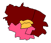
You can imagine the population imbalances here, even ignoring the fact that the Teltow seat included literally every suburb south of the Spree and the Niederbarnim seat everything north of it and east of the Havel.
Don't remind me, I've still got shell shock from trying to figure out the 1907 seats for Bohemia. A lot of the Czech-majority seats boycotted the elections in 1848, but that doesn't really help me in any meaningful sense.
I've been able to make a rough estimation of those seats before, they looked something like this:
View attachment 70993
You can imagine the population imbalances here, even ignoring the fact that the Teltow seat included literally every suburb south of the Spree and the Niederbarnim seat everything north of it and east of the Havel.
The Mitte seat in 1912 had an electorate of 13,407, Berlin 6 was the big one 219,782 but Teltow was something like 282,000+ The population figures were. of course, much larger, both Berlin 6 and Teltow were well over a million people in the 1910 census.
BTW, before setting out on this insane thing I was looking at some of the Reichstag elections, and will likely go back to doing that once I run out of steam. Some more pages from The Books would be very helpful with that, though I appreciate that it's somewhat labour-intensive and annoying to scan/photograph them.The Mitte seat in 1912 had an electorate of 13,407, Berlin 6 was the big one 219,782 but Teltow was something like 282,000+ The population figures were. of course, much larger, both Berlin 6 and Teltow were well over a million people in the 1910 census.
BTW, before setting out on this insane thing I was looking at some of the Reichstag elections, and will likely go back to doing that once I run out of steam. Some more pages from The Books would be very helpful with that, though I appreciate that it's somewhat labour-intensive and annoying to scan/photograph them.
I‘m sure I can manage something.
Caprice
Well-known member
- Location
- Illinois, USA
- Pronouns
- he/they
I must say, as different as American and European constituency boundaries tend to be, they have many of the same problems in terms of mapping. At least I haven't seen straight fractional divisions yet in my state legislative mapping, and I hope I never do.
BTW, as near as I can tell, the total membership of the Assembly was 650, of which 200 were to be elected from Austria (although only 186 ever were, due to boycotts from the Czech population in Bohemia and Moravia) and 191 from Prussia. Although it may have ended up higher, because Posen wasn't initially supposed to be represented - neither it nor the Province of Prussia were part of the German Confederation, and while Prussia was recognised as part of "Germany" by the Vorparlament due to its large German-speaking majority, Posen did not share that trait, and so there was a significant amount of disagreement over whether it should be considered a part of Germany or a part of Poland that happened to be under Prussian rather than Russian or Austrian administration. A few members were in fact elected from the province and seated, mainly representing the German-speaking areas bordering the other parts of Prussia, but both it and the Province of Prussia were promptly excluded from the Confederation again in 1851.
Germany 1848 (current progress)
Okay, so I rather predictably hit a wall after a while. I'm probably going to need old municipal maps of NRW and/or Saxony (@Erinthecute, any ideas on the former?) to be able to carry on, but I'm quite happy with what I got done, and maybe someday I can finish it.
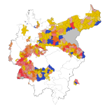
In case anyone's curious, the seat totals for this are as follows:
Donnersberg 21
Deutscher Hof 39
Radicals 60
Württemberger Hof 29
Westendhalle 21
Left-liberals 50
Casino 93
Landsberg 12
Pariser Hof 4
Right-liberals 109
Café Milani (conservatives) 23
Uncertain/no faction 48

In case anyone's curious, the seat totals for this are as follows:
Donnersberg 21
Deutscher Hof 39
Radicals 60
Württemberger Hof 29
Westendhalle 21
Left-liberals 50
Casino 93
Landsberg 12
Pariser Hof 4
Right-liberals 109
Café Milani (conservatives) 23
Uncertain/no faction 48
And here, then, is a new thing: a map of all current Amtrak services. My original hope was to make a map showing all the passenger services that existed before Amtrak took over (because they immediately axed about half of them), but I think this will be a good first step. At the moment I've got everything on the Northeast Corridor and in New England done, and all of upstate New York east of the Schenectady junction. Pennsylvania is also pretty much done, but the fact that it's a horizontal line and writing diagonal text in PDN is very annoying means I haven't gotten around to naming the stations.
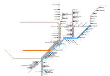
Line widths indicate frequency, as follows:
4pt = 1tpd/direction
6pt = 2tpd/direction
8pt = 3-5tpd/direction
10pt = 6+tpd/direction
I also plan to use 2pt lines for trains running less than once a day, but there aren't any of those on this part of the network.

Line widths indicate frequency, as follows:
4pt = 1tpd/direction
6pt = 2tpd/direction
8pt = 3-5tpd/direction
10pt = 6+tpd/direction
I also plan to use 2pt lines for trains running less than once a day, but there aren't any of those on this part of the network.
Last edited:
Okay, so I rather predictably hit a wall after a while. I'm probably going to need old municipal maps of NRW and/or Saxony (@Erinthecute, any ideas on the former?) to be able to carry on, but I'm quite happy with what I got done, and maybe someday I can finish it.
View attachment 71063
In case anyone's curious, the seat totals for this are as follows:
Donnersberg 21
Deutscher Hof 39
Radicals 60
Württemberger Hof 29
Westendhalle 21
Left-liberals 50
Casino 93
Landsberg 12
Pariser Hof 4
Right-liberals 109
Café Milani (conservatives) 23
Uncertain/no faction 48
Honestly Max, it's crazy how you outdo yourself every time with these projects.
Caprice
Well-known member
- Location
- Illinois, USA
- Pronouns
- he/they
My parents have a book with some form of local governmental maps of the Prussian Rhineland - I'll have to see what exactly it has when I visit next week. It might just be parishes, though - it's a genealogical book, after all.Okay, so I rather predictably hit a wall after a while. I'm probably going to need old municipal maps of NRW and/or Saxony (@Erinthecute, any ideas on the former?) to be able to carry on, but I'm quite happy with what I got done, and maybe someday I can finish it.
View attachment 71063
In case anyone's curious, the seat totals for this are as follows:
Donnersberg 21
Deutscher Hof 39
Radicals 60
Württemberger Hof 29
Westendhalle 21
Left-liberals 50
Casino 93
Landsberg 12
Pariser Hof 4
Right-liberals 109
Café Milani (conservatives) 23
Uncertain/no faction 48
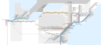
Some more stuff done. I think this is all the lines going into Chicago from the south, but there's a few more heading north. These are actually two separate sets of tracks and platforms - there are two non-revenue tracks running through the station on its eastern end, but all platforms are stub-end, with a passenger concourse in between that does at least make it very easy to get from train to train.
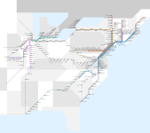
This should be everything east of the Mississippi with the exception of Florida and points north of Milwaukee - no actual services in those areas that don't have other parts represented on the map though.
To the surprise of no one, the South is absolutely dire for the most part - North Carolina is the only state that seems to even try. Virginia as well, I guess, if we count that as a southern state.
msmp
Insert Pine Tree Flag Here
- Pronouns
- he/him/his
Speaking as someone who uses Amtrak frequently (Northeast Corridor privilege, yeehaw!), you do a better job of mapping their system than they do, and it's not a particularly close contest either. Stellar work!
msmp
Insert Pine Tree Flag Here
- Pronouns
- he/him/his
Your maps are making me envy European rail again, Max. 
It remains incredibly irksome that Detroit, despite being a major city (though not as major as it once was), has no connection to the NEC except through Chicago. Why they haven't connected it via Toledo is beyond me. There's enough cross-state commuters that it should at least have been explored; maybe there aren't as many as do the Milwaukee-Chicago route, but still!
Heck, in theory if you got cooperation from Via Rail Canada, you could have trains connect from Buffalo/Niagara to Detroit, though I imagine the infrastructure costs would be relatively high. It already saves a bit of time to drive that route if you're trying to go to NYC from the midwest.
prime-minister
Average electoral map enjoyer
- Location
- Cambridge
- Pronouns
- They/them
I can't imagine how jealous South Dakotan railway enthusiasts must be of North Dakotan ones.All done bar the key. Which I imagine will be very annoying, so here goes.


