• Hi Guest!

    The costs of running this forum are covered by Sea Lion Press. If you'd like to help support the company and the forum, visit patreon.com/sealionpress

Max's election maps and assorted others

I suppose I ought to share what I've been working on in between cat wrangling and job searching (lol). It's kind of a continuation of the theme of US rail, but a rather different part of the network's history - one where the issue was not so much how to keep rail alive as how to keep the incredibly wealthy railroads from forming cartels that strangled the entire country's transport system. To this end, the Interstate Commerce Commission was set up by Grover Cleveland in 1887 and empowered greatly by Theodore Roosevelt in 1906, and after the temporary nationalisation of the rail network during WWI, the ICC saw a golden opportunity to push for the wholesale reorganisation of American rail into more cohesive, economically sustainable systems. They engaged the prominent economist and race scientist (no, really, the other main thing he was known for was actual skull measuring) William Z. Ripley to investigate the state of American rail and determine how best to do this, and he came back with a plan recommending the creation of 21 (actually 19, not counting the Canadian National and Canadian Pacific's American trackage) rail systems made up of combinations of existing railroads. In simplified terms, this could be described as the American analogue to the Grouping Act in the UK, but unlike that, Ripley's plan didn't really prioritise geographic coherence. Instead, the goal was to combine larger and smaller railroads in such a way as to a) ensure each one would be economically viable, and b) make sure as many systems as possible reached as many key markets as possible, so that the different systems could effectively compete for fares and efficiency.

The map below shows the Northeast, i.e. everything east of Chicago and north of the mouth of Chesapeake Bay, and aside from a few branch lines in the Appalachians and some rural lines in southern Virginia, should show all the track that existed as of about 1965. Which is four whole decades after Ripley wrote, but them's the breaks. I've added a few very conspicuously closed lines, but at the end of the day I have very little interest in going through everything that was closed over that entire period.

There'll be more detailed descriptions of the different systems later on, along with a full map.

image.png
That looks like one of those Bodyworks things where they injected wax into all the arteries and veins and it's just them with no body left, but with the United States.
 
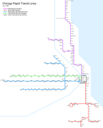
The first in what may be a series: a map of the Chicago L when it first became a single entity. Or rather slightly before, although I don't think there was much actual change between 1921 and 1924.

View attachment 72079
Very nice. Do you know what the origin is of the Northwestern line having a station simply called 'Chicago'?
 
Pretty sure that's the first Chicago Avenue station, because today there are no less than three "Chicago" stops on the L, differentiated by the cross streets during on-board announcements (though fortunately none are on the same line as any of the other two!). That one in particular must be Chicago/Franklin, given it's the only one which would have existed in 1921.
 
Very nice. Do you know what the origin is of the Northwestern line having a station simply called 'Chicago'?
@msmp has got it right - pretty much all stations at this time were named after the intersecting street, and the bulk of them still are. As a result, there are no less than five different stations called “Western”, two of which are on the same line.
 
Pretty sure that's the first Chicago Avenue station, because today there are no less than three "Chicago" stops on the L, differentiated by the cross streets during on-board announcements (though fortunately none are on the same line as any of the other two!). That one in particular must be Chicago/Franklin, given it's the only one which would have existed in 1921.

@msmp has got it right - pretty much all stations at this time were named after the intersecting street, and the bulk of them still are. As a result, there are no less than five different stations called “Western”, two of which are on the same line.
I suppose I can't talk as the regular user of a tram where one of the terminii is called 'Halfway' but that seems a tad confusing.
 
I suppose I can't talk as the regular user of a tram where one of the terminii is called 'Halfway' but that seems a tad confusing.
AFAIK, the only American rapid transit system that doesn’t do this is Boston. Which I think is less to do with high-minded principles and more to do with Boston having a much more “European” street layout than most other American cities.
 
AFAIK, the only American rapid transit system that doesn’t do this is Boston. Which I think is less to do with high-minded principles and more to do with Boston having a much more “European” street layout than most other American cities.
10/10 can confirm having worked for the past decade in Boston lol. The street layout could very easily have come from anywhere in Western/Northern Europe, probably an artifact of being the oldest city in the US that didn't really have much in the way of grid planning done for it.
 
10/10 can confirm having worked for the past decade in Boston lol. The street layout could very easily have come from anywhere in Western/Northern Europe, probably an artifact of being the oldest city in the US that didn't really have much in the way of grid planning done for it.
Most New England cities are like that, yes?
 
I hate Milwaukee Avenue. I hate it so much. Who has a right-angled street grid and then a major thoroughfare that runs at a 40-degree angle to it?

To get to Milwaukee, obviously.

We have something similar here in Philadelphia with Old York Road, except that that road does not go to York in Pennsylvania, or to Yorkshire, and not even to New York, but to the place where you can get a ferry in New Hope so you can get then proceed to New York.
 
I hate Milwaukee Avenue. I hate it so much. Who has a right-angled street grid and then a major thoroughfare that runs at a 40-degree angle to it?

I think every American city has a few legacy streets like that. Portland's eastside grid is broken up by a few major roads (Sandy, Foster, etc) that existed as trails even before settlers came to the region, just because they're the logical paths between rivers and other places people wanted to get to. It's a good bet that they were game trails before that, too. Fun thing to think about while sitting outside the Sandy Hut with a cold one.
 
Chicago: Kelker Plan (1923), first phase
Now to the real reason I started drawing Chicago - some past plans.

The system that existed in 1921 had been largely built in the 1890s - the Northwestern Elevated opened its branch to Ravenswood in 1907, and after the four companies pooled their operations in the Chicago Elevated Railways Collateral Trust (CER) in 1911, focus was placed on improving service and increasing connectivity between the different lines rather than extending the system. Which, considering Chicago doubled in population from one to two million between 1890 and 1910 and reached 2.7 million by 1920, was beginning to pose a problem. Especially so considering the city's growth was mainly in the form of outward expansion rather than densification, with new suburbs springing up like mushrooms around the city.

The city fathers were acutely aware of this, and after World War I they appointed Rudolph Frederick Kelker, an engineer who worked for the city's transportation committee, to draw up a plan for how Chicago's public transportation system could be extended and modernised to meet the needs of a growing city. Kelker's plan, which was published in 1923 under the unwieldy title Report on a Physical Plan for a Unified Transportation System for the City of Chicago (it's usually just called the "Kelker Plan"), called for the rapid transit and surface (streetcar) systems to be unified under a single operator, ideally owned by the city, as well as a large program of extensions to both systems that would bring service to new parts of the city and deal with the chronic capacity issues that already plagued the Union Loop twenty-five years after its opening.

Kelker divided his plan into two phases: the first phase, costed at $218 million (some $3.9 billion in today's money), included measures deemed immediately necessary to meet Chicago's needs as they were in 1923, while the second phase, for a more modest $155 million ($2.8 billion today), was meant to provide for a population of five million, which was the then-projection for 1950. (It turned out that prediction was about right, except that obviously those five million people were a lot more spread out than people in 1923 imagined they'd be)

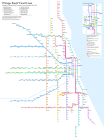
The map below shows the rapid transit system as Kelker envisioned it after the first phase of construction. Key projects include:
- A subway under State Street, starting at a portal and a connection with the South Side L around 16th street in the South Loop and proceeding north through the CBD, turning west at North Avenue and connecting to the Northwestern L around Orleans Street (just east of Sedgwick station, quite a bit south of where OTL's State Street subway connected). This was to be a two-track line except for the CBD section, which would be built with four tracks to allow for short turns if needed.
- Another subway would begin at Blue Island and Maxwell (just south of today's UIC campus), then go east along Harrison Street into the CBD, where it would run under Clark Street, two blocks west of State (and one block west of OTL's Dearborn Street subway), then turn west along Chicago Avenue at its north end and continue as an elevated up to the existing Metropolitan Elevated line at Paulina Street. More on which in a moment.
- The "Paulina Connector" (a name that would not be used for several decades), the north-south line that connected the Metropolitan L's various branches, was to be separated from it and turned into a new north-south trunk line, running along Ashland Avenue through the Southwest Side to terminate at 87th Street, and connecting to the Ravenswood branch in the north before running on its own alignment along California Avenue to terminate at Howard Street near the city limit. This would also be connected to the Stock Yards branch of the South Side L, which would make commutes much easier for all stockyard workers who didn't live immediately near that line.
- To go with the mid-city trunk, the Clark Street subway's southern leg would have two branches: one taking over the Douglas Park branch of the Metropolitan (essentially today's Pink Line), and one continuing south along Ashland, then southwest Archer Avenue, and finally south again on Kedzie, serving most of the Southwest Side's more densely-populated areas.
- In the northwest, there would be two corresponding branches built, one continuing northwest along Milwaukee Avenue and one running west on Belmont Avenue, terminating at Harlem Avenue near the western city limit. The Humboldt Park branch would also be extended west to Austin Avenue, and both it and the Milwaukee Avenue line would have a third track added to allow express service during peak hours.
- The Milwaukee Avenue L would also be extended southeast from Paulina, connecting with the Lake Street L and running into its terminal on Market Street (today's Wacker Drive). I believe Kelker also made provision for the southwestern branches to run into the Metropolitan's Wells Street terminal, but I decided the area around Ashland and Blue Island looked complicated enough without me trying to map that.
- The Ravenswood branch would be extended west along Lawrence Avenue to its intersection with Milwaukee Avenue, where both it and the Milwaukee branch would terminate.
- In lieu of the Northwestern L's North Water Street terminal, a new two-track elevated line was to be built along Austin Avenue (today's Hubbard Street), terminating at the Municipal Pier (today's Navy Pier) and allowing better service to the fast-growing Near North Side. The maps included in Kelker's report only show this line connecting to the Northwestern L from the north, so I assume that would be its only service pattern even though I assume a lot of people would want to travel from there to the CBD. Oh well.
- The South Side L's various branches would almost all be extended - the Stock Yards branch has already been mentioned, but the Kenwood branch would be extended west to meet both the Southwest Side lines and terminate at Kedzie, while the Jackson Park branch would be extended south to 93rd Street along Stony Island and South Chicago Avenues (fun fact: because of how Chicago's street grid works, South Chicago Avenue's street addresses take the format "XXXX South South Chicago Avenue"). A new branch would also be constructed running due south from 61st Street station and terminating at 127th Street. To provide adequate service for all these new extensions, the main line of the South Side L was to be expanded to four tracks, and a new terminal built at Wabash and Van Buren.
- Finally, although Kelker (almost uniquely for Chicago transit planners before about 1990) didn't call for the Loop itself to be demolished, he did want its western leg along Wells Street to be grade-separated from the rest of it, and a short new alignment built south along Wells to Polk and then east to connect to the South Side L. This would allow two alternate two-track routes running north-south through the CBD, effectively creating a four-track corridor all the way from Howard to 61st, and a separate alignment for the "West Side Group" of lines, i.e. the Lake Street and Metropolitan main lines, which Kelker envisioned forming one of the four key trunks of the network.
chicago-kelker-ph1.png

So what parts of this were actually built? Well, not a lot. The State Street subway, along with a subway under Dearborn Street and Milwaukee Avenue that more-or-less parallelled Kelker's Clark Street corridor, were both built in the 1940s, though the latter didn't open until 1951 due to wartime construction stoppages, and the Southwest Side did finally obtain L service in 1993 when the Orange Line opened. And right now, as I write this, the CTA is in the advanced stages of planning for an extension to bring the Red Line down to 130th Street, an extension Kelker deemed immediately necessary a full century ago.

There have also been a lot of outright closures, some probably necessary due to slow and outdated infrastructure, but often also dealing serious damage to communities served. After World War II, Chicago's innermost suburbs would be severely blighted by freeway construction and "slum clearances" that left behind an urban wasteland, and it didn't help when the CTA axed stops in the name of bringing suburban commuters into the city slightly faster, or moved entire lines from busy commercial arteries into the middle of freeways designed to avoid points of density.
 
Last edited:
This is an almost cartoonish level of transport villainy.
It’s very common in American transit planning - the result of the mentality mentioned where the only priority was to let suburbanites get into the city as fast as possible to reduce traffic congestion, rather than trying to serve any of the areas in between. The fact that the outer suburbs were predominantly white and the inner suburbs predominantly black is no doubt purely coincidental to this.

And it gets worse. Until recently, the norm - especially for new-build systems rather than rebuilds as in Chicago - was to surround suburban stations with free parking, leading to the additional spectacle of rail stations that are incredibly hard to use on foot. I got a lot of experience with this during my time in Denver, where the light rail was built along I-25 as part of a compromise by a Republican governor to sell a major road expansion project to Denver’s more liberal voters.
 
It’s very common in American transit planning - the result of the mentality mentioned where the only priority was to let suburbanites get into the city as fast as possible to reduce traffic congestion, rather than trying to serve any of the areas in between. The fact that the outer suburbs were predominantly white and the inner suburbs predominantly black is no doubt purely coincidental to this.
You'll find much the same if you ever try to dig through the hell that is the greater NYC transit network, though it becomes especially egregious when you look at outbound traffic in highway/road terms. In that case, the parkway system on Long Island was intentionally designed with bridges that were too low for buses to get under, blocking Black families from access to the beaches on both the north and south shores of LI. Just another delightful urban planning moment courtesy of Robert Moses.
 
Chicago: Kelker Plan (1923), second phase
So, about that second phase.

The current estimate when Kelker wrote his report was that by 1950, Chicago would have a population of five million - almost twice what it had been in 1920 - and so, as one might expect, Kelker took this growth into account and recommended additional projects to provide the necessary capacity. As mentioned last time, while the growth projections were roughly accurate, Kelker failed to account for the rise of mass automobile ownership and the resulting suburbanisation, so his plan provides interesting AH potential in that it shows what Chicago might've looked like if that development had never occurred. (I personally think it's unlikely to avoid it completely, unfortunately, given the US's large domestic oil supply and the inherent lobbying weight that results, but there are certainly ways in which the total car-dependent hellscape that was post-war US urban planning could've been toned down)

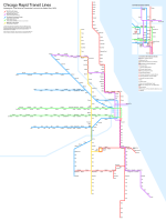
So the two most important projects in the second phase were both subways: one of them would parallel the lake shore, running from Wilson station on the North Side to Cottage Grove station on the Jackson Park branch - and yes, it would be underground the whole way. At $55 million (nearly a billion dollars today), this was the most expensive single project in the entire plan, and accounts for over a third of the entire second phase's cost all by itself. This new line would relieve the State Street subway massively, and I've had it take over the Ravenswood branch beyond Ravenswood itself in the north as well as the branch to 127th in the south. As a result of the added capacity, I've also removed the South Side L's terminal at Wabash Avenue, which is not something Kelker explicitly recommends (he's generally very reticent about demolishing anything), but which I think makes sense given there are now six tracks running north-south through the Loop.

The other new subway recommended was to run under Halsted Street, a key north-south artery on the Near West Side, and similarly relieve the Wells Street L as well as the western branches on the South Side. This is another point where I've sidestepped the plan slightly - Kelker recommends connecting this line to the North Side L at its northern end, but I decided it was too much hassle to map a triple line, so I decided to have it terminate at North Avenue instead. Which is probably not its optimal service pattern - I imagine most trains would run north to at least Belmont, and probably as far as Howard, if this had actually been built. I also believe, given the rapid decline of the Union Stockyards post-war, that this line would've provided sufficient coverage to allow the Stock Yards Branch to be demolished - however, again, Kelker assumes they will remain the city's biggest place of employment by far, so he doesn't recommend this.

Kelker also recommended two streetcar subways be built, one under Washington Street and the other one partly under Jackson Boulevard and partly under Van Buren Street. These would supplement the tunnels already used by the streetcars to cross the Chicago River (fun fact, I guess) and help keep traffic volumes down in the Loop's streets - Kelker seems to lament the necessity of spending money on this, but nevertheless recommends they be built in the second phase because traffic congestion would likely require them. He incidentally has the same attitude to the Loop itself, recommending that it (or rather, its two successor routes, the West Side Group's U-shaped trunk and the separated Wells Street L) stay up but also noting that nothing in his plan would prevent the city from replacing them with subways if the mood should strike.

Beside these, the second phase also included a number of new elevated lines in the suburbs: most notably one along Kedzie Avenue, which would provide a crosstown trunk west of the Mid-City and also take over the southern part of the old Marquette Park L, which is instead extended down Archer Avenue all the way to the city limit. The Kenwood branch would be extended nearly as far west, while both the Humboldt Park and Milwaukee Avenue branches in the northwest would see extensions out to the city limit. As for the Humboldt Park branch, I've detached it from the rest of the Northwest-Southwest routes on here, and this is because of what may be the most baffling line in the entire plan: the Clinton Street L. Kelker simply notes that the Near West Side is growing in importance and density, and that a link will be needed to serve this density, and therefore recommends a new elevated line along Clinton Street between the two West Side routes. The most obvious service pattern for this would be as a simple short-turn of the West Side trunk, but I decided to instead link it to the inner portion of the Milwaukee Avenue L, a line that was itself always very strange, and create a new service linking the Humboldt Park branch and the four-track part of the former Metropolitan main line. On the latter, I think it's very likely that a local-express stopping pattern would be established, with the new line most likely running local to the West Side trunk's express given the relative lengths of the two, but I haven't depicted this on the map.

So this is the final buildout. This system would have 421 miles of revenue track, compared to 162 in the extant system as of 1923, and while I didn't count the number of stations I put in, there were substantial capacity increases along nearly every corridor, with Kelker estimating a capacity of 400,000 passengers per day in the first phase of construction alone. For the record, the L today carries about 320,000 passengers per weekday (although it was close to double that before the pandemic).

Kelker's plan would be the last major one to assume that rail would remain the predominant form of urban transportation - the next tranche of plans, published in 1937-39, were adapted for an age of growing automobile use and tried to have the rail system coexist with a new network of urban motorways. This would be the model eventually followed once Chicago's economy recovered from the Great Depression and World War II, and the results have been somewhat mixed, as discussed in the previous part.

chicago-kelker-ph2.png
 
Back
Top