• Hi Guest!

    The costs of running this forum are covered by Sea Lion Press. If you'd like to help support the company and the forum, visit patreon.com/sealionpress

Max's election maps and assorted others

Oslo, parish history
  • Once again I've been waylaid by something that just kind of happened to be there.

    Medieval Oslo had multiple churches, of which St. Hallvard's Cathedral was the most prominent, but after it burned down in 1624 (the city, that is - the cathedral was actually one of the few buildings to survive the fire), King Christian IV ordered it moved to a new location west of where it had been and modestly renamed it Christiania. The new city had a modern, right-angled street grid, a large military fortress at Akershus that doubled as the seat of government (kind of a kremlin, when you think about it), and a single large church at its single town square, which was named "Vor Frelser" ("Our Saviour" in Danish) as a reminder not to try any of that Papist nonsense around here.

    Christiania remained a small city for the next two hundred years, populated largely by royal officials and their families, and so Vor Frelser was enough to fulfil the spiritual needs of the townspeople until 1858, when the city's land area was extended and it was determined that a second church was needed. Again, a suitably un-popish name was chosen for it, this time "Trefoldighed" ("Trinity"), and the city was split down the middle along Kongens gate, with Trefoldighed handling the west and Vor Frelser (which remained the seat of the Bishop of Oslo) the east. Trefoldighed took in some of the newly-annexed lands to the west, but in the north and east, a large area remained under Aker parish (the rural parish that surrounded Christiania) until arrangements could be made in 1861. The 1858 expansion had actually placed the old Aker church (Oslo's oldest building, dating back to the 12th century) within the city limits, and so the northern outskirts of the city were formed into the parish of "Gamle Aker" ("Old Aker") with the old church as its parish church. The eastern areas became the Grønland parish, simply named for the area the church was in, while the rural parish was split into a western and an eastern part, with each getting its own church.
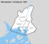
    oslo-menigheter-1861.png

    By this time, Christiania was becoming Norway's industrial capital as well as its administrative one, and its population very soon outstripped what these four parishes could handle. In 1874, every parish except Grønland was split in half, with the eastern part of Gamle Aker forming Paulus parish, the north of Vor Frelser becoming Jakob, and the south-east of Trefoldighed becoming Johannes. Apparently naming churches after the apostles was fine in a Protestant country now. O tempora, o mores.

    In 1878, there followed a second expansion of the city limits, necessary because it was running out of land to build new housing on. Three new parishes were formed out of these annexed areas: Uranienborg in the west, Kampen in the east and Petrus in the northeast (making a nice companion to Paulus). Around the same time, both Gamle Aker and Grønland were split, with Grønland's southern part forming the new parish of Oslo (named after the medieval town once located on its territory) while the north of Gamle Aker combined with some of the newly-annexed land to form the parish of Sagene. Aside from Petrus, all of these were simply named after the geographic areas they covered, and this would continue to be the dominant pattern going forward.
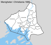
    oslo-menigheter-1880.png

    In less than a decade, Christiania (now often spelled Kristiania, in a slightly "Norwegianised" form) had gone from four to twelve parishes. However, its population kept growing, and now it was the west that needed attention. Uranienborg, Gamle Aker and Trefoldighed were all quite large compared to their eastern neighbours, and while the west was also less densely populated (due to being much, much wealthier), the large parishes were still presenting administrative issues. In 1897, Trefoldighed parish lost territory on almost all sides, and Uranienborg was split in three, with the northern areas becoming Fagerborg parish and the south becoming Frogner. Two years later, Oslo and Kampen gave up territory to the new parish of Vaalerengen, which covered a working-class neighbourhood that had been unacceptably far from either church.
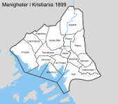
    oslo-menigheter-1899.png

    This was the state of things when Norway became an independent state in 1905, and continued unchanged until 1916, when they decided to do some weird shit. A total of six new parishes were created, mainly in working-class areas, and while a couple of them made sense (splitting Sagene was probably inevitable, since its church was west of the river while most of the population was east of it), some of the others were just a few blocks each, and it honestly surprises me that people ever thought they'd be viable.
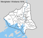
    oslo-menigheter-1916.png

    1916, then, represents the peak concentration of parishes in the city, and from here on, at least for the city centre, parishes are going to get merged rather than split. The only 1916 creations with any real future were Markus, which was later expanded to cover all of Gamle Aker west of Ullevålsveien, and Torshov, which was far from the smallest parish in the city to begin with. By 1938, all four of the others had been suppressed, although some carried on as subunits of their new-old parishes. Johannes was also suppressed in 1926, and in 1938 the Akershus garrison church also lost its parish status, with the result that Vår Frelser (now respelled to fit the modern Bokmål standard) now covered the bulk of the city centre. And of course, in 1925, the city was renamed, taking back its pre-Danish name Oslo. To avoid confusion, the Oslo parish was rechristened "Gamlebyen" ("Old Town") at the same time.
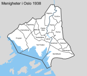
    oslo-menigheter-1938.png
     
    Finland 1880 (languages)
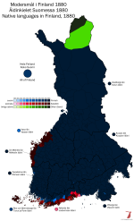
  • As I'm sure you know, one of the long-term projects I'm working on at the moment is a TL where the separation of Finland from Sweden in 1809 doesn't happen (link in signature, or also here if you're on mobile). I've been doing some historical research to determine what the situation was east of the sea before the split, as it will help me figure out where it goes from there (i.e. how bad is the Ireland comparison exactly), and one of the things that led me to was the fact that the first modern Finnish census to count native languages was that of 1880, which placed the proportion of Swedish-speakers at 14.3%. This most likely represented a slight dip from the peak during the 18th century, but most of that was due to the Finns having a higher rate of population growth rather than an actual decline in the Swedish population. In absolute numbers, the population of Swedish-speakers in 1880 was 294,876, which is almost the same as today (287,933), and slightly below the mid-20th-century peak of around 350,000. Of course, the Finnish-speaking population has since grown from 1.7 million in 1880 to just under five million today, and this explains why the proportion of Swedish-speakers has now shrunk to around 5%.

    I was in fact able to find the 1880 census reports on Doria, the Finnish government's document database, and that has in turn allowed me to make a map of Finland by language spoken as of the first reliable data on the topic. The result is, well, a bit dull actually. You might expect that a Swedish population that's almost three times the percentage that it is now would be more geographically spread out than it is now, but this wasn't really the case. Some Swedish-speaking areas were Fennicised during the early modern period, notably the coast around Fredrikshamn, the northwest corner of Satakunta and some of the countryside around Åbo, but after that there was very little population movement. This was actually encouraged by the Church, which resisted efforts by the 18th-century Swedish state to spread the Swedish language because rural priests didn't want to have to deal with bilingual congregations, and the result of this is evident in Ostrobothnia in particular. Vasa and Karleby had small Finnish minorities in 1880, and Uleåborg and Brahestad had very small surviving Swedish elite groups, but other than them, every single parish in the entire region was more than 90% one language or the other. Nyland was a bit more diverse, with several mixed parishes along the language border. Some of these remain bilingual today, like Sjundeå/Siuntio and Kyrkslätt/Kirkkonummi, but the majority are now entirely or almost entirely Finnish-speaking. This includes most of the Helsinki region, but also areas like Lohja/Lojo and Pyhtää/Pyttis, where little trace remains of their Swedish heritage today.

    The main difference between 1880 and today, generally speaking, is that urban areas were much more Swedish then than they are now. Helsinki had a small Swedish majority in 1880, Vasa (then called Nikolaistad) had a compact one, and even Åbo still had a strong Swedish minority. Most other cities in Finland had some Swedish presence, notably Viborg/Viipuri with around 20% and Björneborg/Pori with around 14%, but even a place like Tammerfors/Tampere with its 6% Swedish population held on to its bilingual street signs until the 1920s and still has a Swedish school. These "language islands" (språköar) are, of course, the product of the traditional Swedish-speaking administrative and commercial elite, and tended to be very culturally distinct from the rural Swedish communities which often had more in common with their Finnish-speaking neighbours - even given the Republika Srpska-like isogloss in Ostrobothnia.

    finland-språk-1880.png
     
    Melbourne tram history
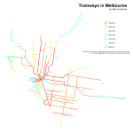
  • melbourne-tram-history.png

    Here's a quick thing I mostly did for my own reference: the tram lines in Melbourne coloured by date of opening. As the key on the map says, this refers to the first time a tram line opened over a given alignment - a lot of them were originally built as either horse or cable tramways and have since been reconstructed, while others have replaced older alignments over similar routes (the Queens Way and Melbourne Park alignments, for example) which aren't shown here.
     
    Los Angeles Railway, 1949
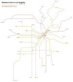
  • Uploading a version without the background directly onto here, just so it won't confuse future readers. Also featuring car barns - and no, you're not mistaken, there was no Division 2. Or to be more precise, Division 2, which was at 54th and San Pedro, closed in 1932, partly because there was redundant capacity in the other divisions and partly because it was in a really stupid location, with only one line (the S car) directly connected to it and long transits required to get to any other line.

    lary-1949.png
     
    Lithuania 1920 New
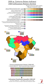
  • Speaking of the Baltics, I finally found something I've spent a long time looking for. Unfortunately it's not as detailed as what I have for Estonia and Latvia, but some enterprising Wikipedian has in fact dug up a statistical yearbook that has all the Lithuanian election results up to 1926 (i.e. all the ones that mattered) broken down to apskritis ("county") level.

    Lithuania is quite different from the other Baltic states, and was even more so in the 1920s. Whereas Estonia and Latvia still carried the legacy of the Livonian Order, being largely Protestant countries dominated by a Baltic German landowning class, Lithuania had been in personal union with Poland until the partitions, and as a result was overwhelmingly Roman Catholic and had a native (albeit heavily Polonised) nobility that owned most of the land. It also had a very large Jewish minority, which Latvia did as well to an extent, and a long and complicated history with Prussia meant there was some German influence as well, just not as heavy as it was in Estonia and Latvia.

    Also, while Russia was generally content to let the Baltic Germans run free in Estonia and Latvia, Lithuania was subjected to some quite harsh Russification policies, including heavy restrictions on the Catholic Church and an outright ban on Lithuanian books written in the Latin script. These policies were intended to separate Lithuania from ever-rebellious Poland and tie it more closely to Russia, and Lithuanians very much saw them for what they were - Catholic priests and patriotic locals organised book smuggling rings which had books printed in East Prussia and taken across the border covertly, and were so successful that Lithuania got one of the highest literacy rates in the Russian Empire. In one sense, however, the printing ban was a success for Russia - the resistance to it did promote a sense of separate Lithuanian nationhood, and after 1905 the prevailing opinion even among the landowning class and the Catholic hierarchy was that Lithuania ought to be an independent state rather than part of a restored Polish-Lithuanian Commonwealth.

    The views of these groups were most closely represented by the Lithuanian Christian Democratic Party, which had been founded in 1890 to safeguard the Catholic Church but became more and more openly nationalist after the 1905 Revolution. The LKDP was very similar in orientation to the Polish Endecja movement, supporting political Catholicism and a radical nationalism that tended to be directed against ethnic minorities within the country as much as outside forces. In the Lithuanian case, this especially meant Poles and Jews, both of which made up large parts of the population. When Lithuania became independent, the Catholic-nationalist movement established a number of side organisations, most prominent of which was the Federation of Labour, which was a network of Catholic trade unions not unlike what existed in Germany at the same time. This helped draw urban workers into the fold of the movement, and a Farmers' Association was set up to do the same for small farmers. The latter was even more closely tied to the LKDP, however, and the results I've found show them running a separate list only in the Kaunas and Raseiniai constituencies, winning seats only in the former. I noticed while writing this that parts of Wikipedia show them winning a total of 18 seats in this election, but I haven't found any information about where those were, so I've left the map as-is.
    Very much like Poland, again, the opposition to the LKDP and its allies was heavily divided. The Lithuanian Peasants' Union was closer to the PSL in ideology than it was to the farmers' parties in Estonia and Latvia, being generally centre-left and drawing support mostly from small farmers and landless farmworkers. The Social Democratic Party had been a key part of the national revival, but found its electoral reach quite limited - especially compaed to its sister parties in the other Baltic states. There was also the Socialist People's Democratic Party, which was a more conservative social democratic group that had been founded out of the former Lithuanian Democratic Party (which was also the originator of the Peasants' Union). Finally, of course, the ethnic minorities had their own organisations - the most prominent of these was the Jewish Democratic Union (also called the Jewish National Union in some sources), founded for the 1920 election as an electoral alliance between the main Jewish groups operating in Lithuania.

    The 1920 Constituent Assembly elections were the first democratic elections ever held in Lithuania, and were organised by the provisional government that had been formed under German occupation during World War I. The Assembly was intended to have 150 deputies elected from ten constituencies, but only six constituencies were actually able to hold elections. The remaining four - based in Vilnius, Lida, Grodno and Bialystok - were under the control of Józef Pilsudski's Polish army, which intended to restore the Commonwealth and rejected Lithuanian claims even to its historic capital as a result. Of course, Vilnius was overwhelmingly not ethnically Lithuanian (according to the 1897 census, its population was about equal parts Poles and Jews with Russians in third place and Lithuanians forming about 2-3% of the population), so we end up in the awkward position where the ethnic-nationalist Lithuanian government claimed it as a result of historic and cultural ties while the more pluralistic and expansionist Polish state cited its ethnic composition as a reason not to cede it. Poland would end up forming a "Republic of Central Lithuania" encompassing the city and its surroundings in late 1920, holding a pretty questionable election there in January 1922 and then annexing it into Poland directly.

    The Constituent Assembly convened at the city theatre in Kaunas, the "temporary capital" designated in Vilnius' absence, in May 1920, and of the 112 deputies who were actually able to take their seats, 58 were affiliated with the Catholic movement - 10 with the Federation of Labour, either 3 or 18 with the Farmers' Association, and the remainder with the LKDP. This was enough to form a majority government, but the LKDP leadership still decided it was best to form a grand coalition, and invited LVS leader Kazys Grinius to form a government. LKDP stalwart Aleksandras Stulginskis was elected to chair the Assembly, however, which made him the de facto head of state until a constitution could be written.

    val-lit-1920.png
     
    Riga 1920 (rough map) New
  • I'm working on mapping the 1920 Constituent Assembly election, and while the pre-reform Latvian orthography means it's somewhat slow going, I am most likely going to be able to do it. The report includes results by polling station for Riga, which unfortunately don't map to any known administrative divisions, but since the report does list the addresses of the polling stations themselves, we can draw up a rough map of the results nonetheless.

    Riga's political geography in this era sort of reminds me of Budapest - well, specifically the Pest half, there's not really much of a Buda equivalent. You've got the relatively contained old-town area (they're even shaped about the same, although obviously Riga has much more of a medieval town core than Pest does since all that stuff would be in Buda Castle) with the surrounding ring of boulevards, then a series of suburbs radiating out from that along the main roads. Of those, the ones north of the old town are the flashiest, displaying a large amount of Jugendstil architecture and being home to a lot of the city's German-speaking elite. The suburb along the river to the south is the poorest, notably being home to the city's Jewish (and in Riga's case, also Russian) minority, while the ones in between the two are working-class and largely ethnically homogenous.

    Of course, the German minority was much bigger in Riga, and made up much of the city's elite. They lived largely in the old town and surrounding areas, but also spread out into the suburbs north and west of town in particular - other than that, the west bank appears to have been mostly Latvian and working-class. So, too, the outer suburbs on the east bank, which were (and are) home to much of Riga's heavy industry and recorded some of the highest Social Democratic voteshares in the city.

    The party names should be self-explanatory, with the possible exception of the Nonpartisan Citizens' Group (Bezpartejiskā pilsoņu grupa), which I assume was a list made up of small business owners and other centre-right types - it's a bit hard to tell as they only stood in this election and Latvian Wikipedia doesn't even have an article on them. But they seem to fill broadly that kind of niche.

    yco4YXL.png
     
    Latvia 1920 (redux) New
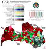
  • Okay, so here's the 1920 Constituent Assembly election in all its confusing glory. I'll copy-paste the description I wrote for the old map I made of it:
    This election was called pretty much immediately after the armistice between the Latvian national forces and the Red Army in February 1920, and held in April, before there was even a formal peace treaty in place. So the Russian Civil War was very much still raging at this point, even if it wasn't raging within Latvia anymore, and the Bolsheviks, who had some measure of support among the Latvian workers, boycotted the elections. This meant there was effectively only one left-wing force available to vote for - the Social Democratic Workers' Party, organisationally descended from the Latvian Mensheviks, who consequently cleaned up and won nearly 40% of the vote. This wasn't enough for a majority, however, and between the two different Agrarian parties (Latgale had its own one, because they're kind of weird even now and were extremely weird before that part of the country was swamped by Russian migration during the Soviet era), the small bourgeois parties and the various ethnic minorities, the Assembly was essentially centre-right in temperament. The Constitution they wrote, the Satversme (a neologism intended to sound more Latvian than the usual "konstitūcija"), created a parliamentary republic with broad judicial and popular oversight over public power, avoiding most of the social rights that were becoming popular to put in constitutions around this time as well as any notion of abridging the right to private property. A bill of rights was intended to be passed along with the Satversme, but this was voted down by the assembly and not added to the constitution until 1998.

    A couple of finer points that I didn't deal with at the time, because the old map wasn't detailed enough to show them: the Latvian state defined its borders, at least provisionally, based on the uyezds (districts; apriņķi in Latvian) of the Russian Empire, simply because those were the administrative units that already existed. Those borders would end up changing, sometimes in Latvia's favour and sometimes against it, following border agreements conducted in 1920-21 with all neighbouring countries, but even in April 1920 they didn't perfectly match what the government in Riga actually controlled. In particular, most of Ilukste district was under Polish occupation following their counteroffensive in the Polish-Soviet War - there was a substantial Polish population in the region, as we can see from the fact that the Polish list was the biggest in both Daugavpils and Kraslava, but Poland was not successful in pressing this claim and eventually handed the area back to Latvia.

    There were also a number of parishes along the northern border that were under Estonian control, and a couple would eventually get handed to Estonia - the most notable dispute here concerned the town of Walk (its German name - Valka in Latvian, Valga in Estonian), a rail junction that sat right on the border and had a mixed population. Both countries wanted it, Estonia because of its rail junction and slight Estonian majority and Latvia because it was the seat of a district that was otherwise pretty much all Latvian. In the end, the British civil servant Stephen Tallents was invited to arbitrate the issue, and drew a new border that split the town in half. Estonia got the railway station and most of the town centre, Latvia got the western suburbs and approaches to the station. Two separate town councils were set up, and this situation was only really undone when the two countries joined the Schengen Area in 2007.

    The border with Lithuania, meanwhile, did not see any such caveats in this election, which is sort of interesting because it means Palanga got to vote in its first and only Latvian election. Like the rest of Courland, it was extremely left-wing - the rural municipality was almost entirely red, while the town was divided between the socialists and a Jewish unity list. To my surprise, Akniste also voted in 1920 even though it had been part of Kovno province, but the other two parishes ceded by Lithuania in exchange for Palanga did not seem to have participated in this election.

    Also, I had to use 13 out of 16 sets of shades for this, so I'm sorry if parts of it are hard to read. I was particularly hoping I'd be able to avoid the grey shades, but at the end of the day, I think distinguishing the LgLP from Ceire Cion is more important than distinguishing them from occupied areas.

    val-lv-1920.png
     
    Latvia 1922 (redux) New
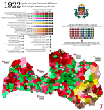
  • And 1922. There's less to add to this, in part because I described it more thoroughly at the time and in part because I actually mapped it by parish at the time.
    The Constituent Assembly lasted about two years, during which time it managed to pass a number of significant laws beside the Satversme - it set up key cultural institutions for the new republic, established universal public education, reformed marriage and property laws (including a massive land reform intended to increase the number of self-owning farmers, a measure that probably had a bigger impact on Latvian society than the new constitution itself), and reformed the local government system to make town and parish councils directly elected under universal suffrage (under the Russian system, the richest landowners sat on the council by right while the other landowners got to elect representatives and the landless had no say whatsoever).

    The centre-right "unity coalition" that had governed Latvia through the independence struggle fell in June 1921 for reasons unknown to me, and was replaced with a new coalition between the agrarian parties, the centrist Workers' Party (now fading into irrelevance everywhere but Latgale) and a breakaway right faction of the LSDSP, who dubbed themselves the Mensheviks (mazinieki, a word that I've also seen translated as "minimalists"). The new government was led by Zigfrīds Anna Meierovics, previously the Foreign Minister under Ulmanis, who was half-Jewish (as the surname hints) but grew up in rural Courland and considered himself Latvian through and through, leading as he did the first Latvian cabinet with no national minorities represented. His government's activities were concerned largely with further statebuilding, including the establishment of the lats as a new national currency and the standardisation of Latvian spelling, replacing the old orthography based on German with a new one that closely represented the language as spoken (hence all the diacritics in modern Latvian writing).

    With the Satversme passed and set to go into effect in November 1922, the Assembly dissolved itself and called for a new Saeima, or parliament (the Latvian word is almost certainly related to the Polish sejm, both meaning "meeting" or "assembly", but there was a fun controversy in the 19th century where a Latvian nationalist claimed to have "coined" the term independently and strenuously denied it had any connection whatsoever to any other language), to be elected in early October. The electoral law used for the Constituent Assembly was essentially carried over to this new body, with two slight modifications - firstly, the number of seats up for election decreased from 150 to 100, which was deemed enough for a country the size of Latvia, and secondly, the voter would now be allowed to strike out names from party lists and replace them with candidates from other lists - a form of panachage, basically. The Constituent Assembly spent a lot of time discussing Switzerland as a model for republican government, and no doubt this innovation came from there.

    The elections resulted in some losses for both the LSDSP and the agrarians, who did especially badly in Latgale - the Latgalian Farmers' Party was reduced to a single seat, its place as the main voice of rural Latgale taken over by the Christian Farmers' and Catholic Party, which was an overtly Christian democratic organisation modelled on the German Centre Party and directly supported by the Catholic hierarchy. The liberal Democratic Centre also gained slightly, while the minority bloc essentially stayed put (as one might expect). The Mensheviks, who had hoped to seriously compete with the "rump" LSDSP for the working-class vote, suffered what can only be described as a fiasco - with some 6% of the vote and seven seats, they did place third, but it was a poor third, and not enough to save their coalition with the agrarians in government. When the First Saeima met, it elected an LSDSP member to chair it, and President Čakste called on the LSDSP to attempt to form a government. The overall left-right balance hadn't really shifted, however, and they would be hard-pressed to find anyone willing to support them.
    I may at some point go over the results in detail to see if I can untangle the "other" category used for the percentage section of the report, but that will have to be when I'm even more unemployed than currently.

    val-lv-1922.png
     
    Los Angeles 1949 New
  • So I've been getting into two different areas lately: the Baltics, and Los Angeles. Why these two at the same time, you may ask? I don't know, but here's the other one.

    Since 1925, the Los Angeles City Council has used pretty much the same electoral system: fifteen members are elected from fifteen single-member districts, with no party affiliations shown on ballots and elections every two years. Today, half the council is up for election each time, providing four-year terms, but this only came about in the 1950s, prior to that councillors served two-year terms and all fifteen seats were up in every election.

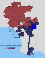
    In theory, at least. This being the US, and in spite of the nonpartisan ballots being meant as a way to prevent party machines from forming, most incumbents tended to run unopposed. In 1949, the election I looked at first (because it's the first one I could easily find district boundaries for), only one (1) seat had a contested election, with District 9 incumbent Parley P. Christensen losing to fellow Democrat Edward R. Roybal. Roybal is historically significant because he was descended from an old New Mexican Hispanic family and is usually considered LA's first Latino councillor (although you do have to add "in modern times" to that, because of course there were a number of Californios elected to the council in its early days).

    (It is worth noting that "how many council seats are contested" isn't quite as secure an indicator of local democracy in the US, and particularly in California, as it is in countries like the UK - LA had a fiercely-contested mayoral election in the same year, and of course there were constant referendum campaigns. Still, always worth remembering the downsides of the "golden age of bipartisanship")

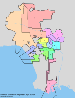
    With all that in mind, I think the district map is more interesting to look at than the actual election map. The fact that the districts got redrawn frequently but never changed in number means you can follow LA's urban sprawl very effectively, and well, what we see in 1949 is certainly a more concentrated urban area than what exists today, but it's still not that dense. LA was never a very dense city, it was advertised as the sort of place where people could have the amenities of a city without becoming city people - at this point it was still one of the most productive agricultural regions in the US, and car ownership had been the norm for most (white) households even before the war. Even so, as we can see, settlement was largely concentrated around downtown and the few miles surrounding it. South Central ended around Watts and Inglewood, the Westside wasn't quite fully built-up all the way to Santa Monica, and the San Fernando Valley was rural enough that only one of the fifteen seats (District 1) was contained entirely within it. District 2 would likely have had a large part of its population in the Valley as well, but it also included much of Hollywood, so it's hard to say. Of course, most of the southward and eastward sprawl happened outside the city limits, so will be hard to discern from this - it's really mostly going to be the Valley's growth that will make an impact.

    Of course, LA County has its own legislative body, the Board of Supervisors, elected using much the same system, but trying to map those districts would likely be a lot of work for limited returns considering there are five (5) of them for the entire county.

    la-dist-1949.png
    val-us-la-1949.png
     
    Back
    Top