Here it goes then. These are 1898 boundaries on the island of Ireland, so that should be fine. Scotland and Wales are in their 1947 boundaries, and England is allegedly 1931 but anachronistic for that date (
@Alex Richards has details on that).
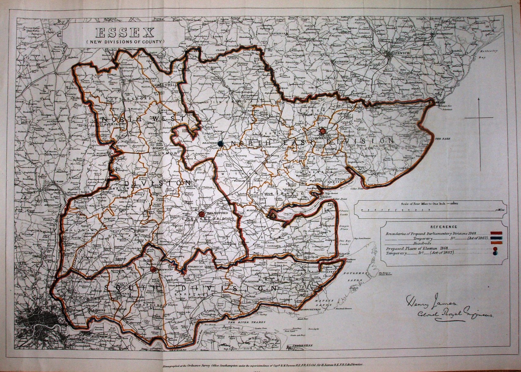
Thank you very much - that is a beautiful map and I will do my best to find and compare it against county-level maps which purport to be more accurate to the turn of the century.
And because I inhabit the borderline space between "compulsively helpful" and "control freak", have a version with the English counties you list above and the Scottish divisions previously made:
I would add the Welsh and Irish ones too, but it's 2am here and even I have limits.
Thank you
so much! I'm totally blown away. Please feel free to continue with your compulsive helpfulness!
Also, I’d try to separate out any county boroughs big enough to form their own constituencies, since they were administratively separate from the counties that surrounded them. Even in counties small enough to form single constituencies - though the only one that’s likely to apply to is Nottingham.
Agreed - wholeheartedly. These are:
Leicestershire, which is divided into the town of
Leicester, with a population of 225,911 (
3 MIPs) and the remaining county of
Leicestershire, with a population of 211,579 (
3 MIPs). The town of Leicester was an early stronghold for the Labour Party, with future PM Ramsay MacDonald winning one of the two seats there in 1906 (one of just 29 Labour victories in the whole UK), and it is thus extremely likely that one of the three MIPs to be elected there in the first Imperial election will also be Labour.
Nottinghamshire, which is divided into the city of
Nottingham, with a population of 239,743 (
3 MIPs) and the remaining county of
Nottinghamshire, with a population of 274,716 (
4 MIPs).
Gloucestershire, which is divided into the city of
Bristol, with a population of 328,945 (
4 MIPs) and the remaining county of
Gloucestershire, with a population of 305,784 (
4 MIPs).
Northumberland, which is divided into the city of
Newcastle-upon-Tyne, with a population of 215,328 (
3 MIPs) and the remaining county of
Northumberland, with a population of 387,791 (
5 MIPs). One of the two seats in Newcastle-upon-Tyne was another to be won by Labour in 1906, so one of the three MIPs will almost certainly be Labour at the first Imperial election.
Warwickshire, which is divided into the city of
Birmingham, with a population of 522,204 (
7 MIPs) and the remaining county of
Warwickshire, with a population of 417,700 (
5 MIPs). Although Labour didn't do nearly as well in Birmingham as might be expected prior to WWI despite the city's great size and industry (probably because it was a Chamberlain and Liberal Unionist fiefdom), they still nearly won Birmingham East in 1906 and also got a third of the vote in Birmingham Bordesley that same year. (Better than they did in Birmingham in either 1910 election, believe it or not!) Therefore, one of the seven MIPs is likely to represent Labour at the first Imperial election, alongside at least one and probably two Chamberlains (Neville is more domestically-minded, he can stay in the English Commons) and any number of other Liberals and Unionists in the other four seats.
This leaves the following counties which need to be divided more precisely: Cheshire (11), Durham (16), Essex (14), Hampshire (10), Kent (13), Lancashire (58), Middlesex (11), Staffordshire (16), Surrey (25), and the West Riding of Yorkshire (37).
The Derbyshire split's been done as well of course.
Indeed it was, thank you again for that.
Alex Richards said:
Oh and do not get me started on the inaccuracies of the 1931 English Districts map. Every time I do more research I find another error.
They're thin on the ground, but wherever I can find more contemporary maps I plan to use them. It really depends on the county. Lots of great maps of Warwickshire and now Essex but other counties are
very difficult to map correctly.
Alex Richards said:
EDIT: Oh and the Soke of Peterborough was traditionally associated with Northamptonshire at this point, not sure how that complicates things wrt Huntingdonshire.
That's what I get for accidentally looking at the 1965-74 map first. Thank you very much for the correction, it has been noted and logged.
The Only Way Is
Essex, which will be the subject of my next boundaries map, as I've found maps of contemporary divisions which I can use as a basis for the lines. You might well say I'm an Essex Man. You can expect that sometime soon.