• Hi Guest!

    The costs of running this forum are covered by Sea Lion Press. If you'd like to help support the company and the forum, visit patreon.com/sealionpress

Imperial Parliament STV Constituencies

Well, starting off logically, I think Toronto by itself can be a 3 MIP constituency, and definitely can if you also include the three ridings of York county (I'd probably call that one something along the lines of Toronto - York County to avoid confusion with Yorkshire). There's another logical 6 seat grouping in the form of the Essex-Elgin-Middlesex-Kent-Lambton-Oxford-Perth-Huron grouping effectively anchored by London (Ontario South West methinks). Then you've got a 5 seat grouping based around Hamilton for everything left south of Wellington and Peel counties inclusive (Hamilton or Niagara methinks). There's another 3 seat grouping for Ottawa based on Carleton, Grenville and points east. (Ottawa) Another 6 seater can be formed from everything south of Muskosa and Nipissing exclusive (Kingston - East Ontario?). Then you could put the rest in a 7 seat configuration for North Ontario I think.
 
Well, starting off logically, I think Toronto by itself can be a 3 MIP constituency, and definitely can if you also include the three ridings of York county (I'd probably call that one something along the lines of Toronto - York County to avoid confusion with Yorkshire).
Toronto can indeed form a three-seat constituency all by itself (with a population of 208,040, it would return 2.81 MIPs, rounded up to three.) Creating a York County seat gives us 3.69 MIPs, rounded up to four. I agree that a Toronto-based constituency which encompasses all of York County would be called Toronto--York. My idea for Ontario constituencies is to have at least one based on the five major cities of Ontario at the time: Toronto, Hamilton, London, Kingston, and Ottawa. A sixth seat would encompass what was at the time called "New Ontario" - the North, so named because much of it was only added to Ontario in the late nineteenth century. IOTL, Ontario's borders were finalized in 1912 with the final annexation from the Northwest Territories of the Hudson Bay basin (north of the Albany River, originally called the Patricia District, presumably after then-Governor-General Prince Arthur, Duke of Connaught's popular daughter Princess Patricia, she also of the Light Canadian Infantry IOTL). The boundaries of the "North" are elementary to define because it would encompass all unincorporated districts (i.e. non-counties) of Ontario. On the map (which I will reproduce here on this new page) these are as follows:

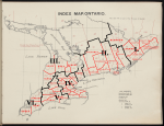
Algoma East, Algoma West, Nipissing, Parry Sound, Muskoka, and (the off-map) Thunder Bay and Rainy River. The problem is that these constitute a population of only 117,321, and would return only 1.98 MIPs. In initial maps I added Renfrew County (North and South) to arrive at the magic number (2.68) but this is unfair to the residents of that incorporated county. So I have two options. Either have the Ontarian delegation try to brute force a two-seat proposal for Northern Ontario or put my very leaden finger on the scale to bring us to three at the expense of one MIP from Southern Ontario. I might go with the former. If I do, that means we split the remaining 28 MIPs five ways. Most evenly distributed, this gives us five Southern constituencies sized 6-6-6-5-5. Toronto-York is only a four-seat constituency, and Torontonian interests won't want their votes diluted by farmers in adjacent Ontario or Peel or Simcoe Counties. (Yes, STV ideally is supposed to prevent that, but these are "FPTP thinkers" who might not get it right away). If we want more equally-sized districts, we'll want smaller ones. 28 very naturally divides into seven districts of four, for eight total. I came up with eight districts, but they are not all apportioned equal:
Ontario Constituencies.png

I. Ottawa--St. Lawrence. Centred on the city of Ottawa, this constituency contains every county which borders either the St. Lawrence River or the Ottawa River (the Ottawa is a tributary of the St. Lawrence and they meet in Quebec territory). The exception is Lanark County, which is very much within the Ottawa orbit. Population 361,611 - 5 MIPs.
II. Kingston--Ontario. Every county east of York County and Lake Simcoe which is not part of Ottawa--St. Lawrence. Most of these border Lake Ontario, hence the name. Kingston, as you can see, is on the extreme eastern end of the constituency. Population 322,069 - 4 MIPs.
III.
Simcoe--Huron. Every county which borders either Lake Simcoe or Lake Huron, which does not border either Lake St. Clair or Lake Ontario. Dufferin County, like Lanark County, is part of this constituency as it is obviously within its orbit. The largest settlement within this constituency is Owen Sound, population 8,776 in 1901, so this is very much a rural constituency. Population 293,781 - 4 MIPs.
IV. Hamilton--Niagara. Every county which borders Wentworth County (of which Hamilton is the seat) or Lake Ontario west and south of York County, or the Niagara River. Very much an orbital Hamilton seat, it also contains several other substantial settlements, including Brantford (the sixth-largest city in Ontario, with 16,619 people), Berlin, St. Catharines, and Galt. Population 350,225 - 5 MIPs.
V. London--Erie.
An orbital London seat - every county bordering Middlesex County except those also bordering Lake St. Clair, and also Norfolk County under the same Dufferin-Lanark "regional orbit" exception. Other settlements of substantial size in the constituency are Stratford, St. Thomas, and Woodstock. Population 263,710 - 3 MIPs.
VI. St. Clair. A relic of the Upper Canadian "Western District" which endured for several decades. An agricultural "heartland" riding whose largest settlement is the border town of Windsor, population 12,153. IOTL, of course, Windsor would become the bulwark of the Canadian automotive industry in the early 20th century, though in 1901 the Ford Model T is still seven years away. Population 172,580 - 3 MIPs.

I could have combined London--Erie and St. Clair into a single six-member riding, but that struck me as too large (and a bit sprawling). I actually put my finger on the scale a bit - London--Erie would return 3.57 (4) MIPs and St. Clair would return 2.33 (2) MIPs but I rounded in the other direction.

And the two un-numbered constituencies:

Nipissing--Superior. Named for the two lakes on either side of the constituency. By far the most geographically extensive constituency in Ontario. Consists of all incorporated districts of Ontario, aka "New Ontario". Population 146,308 - 2 MIPs.
Toronto--York. The smallest constituency in Ontario, consisting entirely of York County. Toronto comprises over two-thirds of its population. Population 272,663 - 4 MIPs.

That provides us with a distribution of 5-5-4-4-4-3-3-2, with 4 as the median and mode size of each constituency and 3.75 as the mean.

For additional reference as to all 85 federal ridings and their "value" within an Imperial constituency (by hundredths of MIPs) I've concocted another table for reference:

Ontario Table.png
 
Those OTL seats are really slightly less horrifically malapportioned than I would've expected.

The real fun will be Québec - here I'd assume the same logic that animated the constitutionally mandated Senate divisions (creating a balance between Francophone-majority and Anglophone-majority areas, though in reality it would be seen by the nationalist élite as yet one more attempt to attempt to assimilate French-Canadians) would also be at work here, which would lead to some potential craziness probably bordering on malapportionment. Though with our friend doing the ridings here, things might be much less horrible than what could have happened had someone else been given the job.
 
Those OTL seats are really slightly less horrifically malapportioned than I would've expected.
Quebec helps pick up the slack on that front, as I've recently discovered.
The real fun will be Québec - here I'd assume the same logic that animated the constitutionally mandated Senate divisions (creating a balance between Francophone-majority and Anglophone-majority areas, though in reality it would be seen by the nationalist élite as yet one more attempt to attempt to assimilate French-Canadians) would also be at work here, which would lead to some potential craziness probably bordering on malapportionment. Though with our friend doing the ridings here, things might be much less horrible than what could have happened had someone else been given the job.
An advantage of STV is that Anglophone and Francophone minorities in their respective regions will both be represented so long as the constituencies are sufficiently large. In fact, Quebec will probably be one of the earliest places in the Federation (other than Ireland, where such parties already exist) where what I like to call "minority nationalist" groups will emerge. Henri Bourassa, the most significant French-Canadian nationalist between Louis-Joseph Papineau in 1837 and Rene Levesque in 1976, actually formed a political party in 1903 called the Ligue nationalist canadienne (Canadian Nationalist League) which contested the provincial election in Quebec in 1908. I see no reason why the party couldn't go federal - or Imperial.

I'd forgotten about this project - nice work @Brainbin .
Thank you, Thande! I'm trying to get back in the swing of things after a long-ish absence and it's nice to see everyone coming back.

Thande said:
While I know Ontario reasonably well, I'm looking forward to when you get to splitting up the West Riding into constituencies!
That is certainly going to be an intriguing challenge. At least the rest of Yorkshire is easy enough!

My first thought was "wait, western Ontario was a single riding?"
I have to admit it took me a second to figure out what he was saying as well. Knowing @Thande he would probably say "not only does Riding only refer to the three Ridings in Yorkshire, but if you say "west", "north", or "east" without qualification everyone will always know you to be referring specifically to the three Ridings and no-one could ever imagine you might be referring to anything else." ;)

Fun fact: there actually was a West Riding of York County (Ontario) in the early 19th century. It consisted of what is today the Regional Municipality of Peel.
 
Fun fact: there actually was a West Riding of York County (Ontario) in the early 19th century. It consisted of what is today the Regional Municipality of Peel.
I bet that was on purpose, considering there were a fair few Yorkshire people there at the time (and no I am not just basing this on the boss in Murdoch Mysteries).
 
My, the dust accumulates quickly, doesn't it... time to do some housekeeping!

La Belle Province

Armoiries_du_Qu%C3%A9bec_%281867-1939%29.svg


Quebec was one of the four charter provinces of the Dominion of Canada upon Confederation in 1867, and the only one with a majority French-speaking population, a legacy of the province's history as the heartland of New France, a French colony from 1608 to 1763. Since Confederation, it has always been the second-most populous province in Canada, a trend which continued in 1901 when a population of 1,648,898 was recorded. Since the American Revolution, Quebec has had a sizeable Anglophone minority, traditionally concentrated in the cities (particularly Montreal) and the Eastern Townships near the American border. However, the Francophone population enjoys a higher birthrate - one of the highest in the "civilized" world - allowing them to maintain their majority in the province despite high immigration in what they dub la revanche des berceaux, "revenge of the cradle". Thus the census records 1,322,315 persons of French origin, against 290,169 persons of British origin. However, in recent years, few immigrants have chosen to settle in Quebec, instead "stopping over" on the way to the vast tracts of land in the Canadian prairies. Indeed, the population of Quebec of neither British nor French origin is negligible: the third-largest group are in fact Indians (as in, Aboriginal Canadians) with only 9,166 persons. The fourth-largest group, and the third-largest settler group, are Jews with 7,607 persons. These live overwhelmingly in Montreal, with 6,908 of them in the city's seven urban electorates, and in fact the majority (5,030) live in a single riding, Montreal, St. Lawrence. (The entirety of Canadian Jewry in 1901 number 16,131 souls, for reference, which demonstrates Montreal's prominence as a centre for the Jewish community in Canada.) What does Quebec look like on a map? Comme ça:

.item


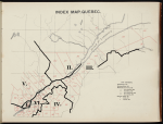
As you will recall from the map of Ontario, the electoral districts numbered 108 (Labelle), 128 (Pontiac), and 149 (Wright) are not pictured here, as they are pictured there instead. Many of the ridings with no clear boundary on one side can be assumed to extend to the provincial border, as explicitly described in the detail maps of the ridings in question. With that said, the 65 Quebec ridings, their population at the time of the 1901 census, and how many hundredths of an MIP they would elect on their own are as follows, in alphabetical order:

Quebec Ridings.png

I've completed a draft map of how I think the Imperial constituencies would look, but I'll hold off for a little bit (not several months, I promise, more a day or two max) partly to remind everyone that this thread exists and partly so that I don't pollute a single post with images. Once I'm done with Quebec I could go back to England (I was working on Warwickshire since - spoiler alert which probably really isn't - Birmingham is going to be Very Important in the early going) or perhaps look at Australia, if only to see how well their census archiving compares to that of the United Kingdom and Canada. (Also I'm finally in the early planning stages of the timeline which will eventually feature this Parliament of the Imperial Federation, although that won't be ready for some time. But it's getting there!)
 
Last edited:
When were these boundaries drawn? I’d be sort of curious to know if they’re holdouts from the time of Confederation or if 6:1 discrepancies were actually considered acceptable at the time.
 
When were these boundaries drawn? I’d be sort of curious to know if they’re holdouts from the time of Confederation or if 6:1 discrepancies were actually considered acceptable at the time.
These boundaries were drawn in 1903 (and first used in the 1904 federal election IOTL), but there's a clear continuity with the design principles used from Confederation.
 
What were those? Historical administrative divisions?
Basically. Quebec is weird because its divisions are based on the colonial seigneuries, which were long, thin strips extending from the St. Lawrence River into the hinterland. The borders of what was then Lower Canada are basically as far as the seigneuries went, which is why there's a small portion of Quebec (Vaudreuil and Soulanges) on the Ontario side of the Ottawa River north of the St. Lawrence.

Quebec.png

Here we have La Belle Province, divided into six constituencies which will return a total of 22 MIPs (or in French, députés d'Assemblée imperiale) to the Imperial Parliament! These are as follows:

I. Montreal (Montréal). The city of Montreal, the entire island of Montreal, as well as the neighbouring Jesus Island, and the surrounding islands - in short, the bulk of the Hochelaga Archipelago. Population 371,086 - 5 MIPs. Has by far the largest English-speaking population of any Quebec constituency, also the wealthiest and most urban.
II. Quebec (Québec). Quebec City and its environs north of the St. Lawrence River, along with the Saguenay and the frontiers of Northeastern Quebec. Population 198,036 - 3 MIPs. One of the smaller Quebec constituencies, dominated by the elite of Quebec City.
III. Beauce--Bonaventure. So named because it extends from the Beauce Valley to Bonaventure at the tip of the Gaspé Peninsula. Population 281,867 - 4 MIPs.
IV. Eastern Townships (Cantons de l'Est). The historical region settled by United Empire Loyalists in the late 18th century. Retains a sizeable Anglophone minority, generally Tory in character. Population 215,262 - 3 MIPs.
V. The Laurentians (Les Laurentiens). Named for the mountain range which extends well beyond the boundaries of this constituency. Entirely north of the St. Lawrence and Ottawa Rivers, it contains the third-largest city in Quebec, Trois-Rivières (still called Three Rivers in English at the time) at its extreme eastern edge, and borders the Ottawa River and Quebec's western border (not shown on the map) at its western edge. Population 305,484 - 4 MIPs.
VI. South Shore (Rive-Sud). Very much an "and the rest" constituency, but focusing mainly on the towns to the south of Montreal, south of the St. Lawrence but west of the Eastern Townships and the Beauce region. Population 274,758 - 3 MIPs (rounded down from 4).

As I've mentioned before, Quebec is likely to return what I call "minority nationalist" MIPs to the Imperial Parliament, alongside the Conservatives and Liberals, the two dominant parties in Canadian politics at the turn of the 20th century.

And that's Canada done and dusted; all other provinces have fewer than 7 MIPs and are comprised by a single constituency. Probably back to England next; Australia unfortunately didn't do their first proper census until 1911 - the individual states conducted the 1901 censuses and the records are harder to find (no I don't want to know about my family history!). Australia's method of apportionment is unusual as well; it's entirely dependent on the number of Senators (double the total number of Senators, apportioned by state according to population), so in the end I think we'll be looking at ad hoc boundaries for those Australian states large enough to require more than one constituency. At the very least I can certainly do an overview of Australia if anyone is interested. Or if we'd rather just return to England, I can certainly do that too.
 
Last edited:
River frontage borders are very common throughout the American West - what makes Quebec weird is that their ones are based on lines directly perpendicular to the river instead of compass points.
Don't they redefine compass points to be relative to the river?
Which also probably isn't uncommon, but ISTR in Montreal it results in them being perpendicular to the traditional ones.
 
Don't they redefine compass points to be relative to the river?
Which also probably isn't uncommon, but ISTR in Montreal it results in them being perpendicular to the traditional ones.
They do that with the Mississippi, in common parlance - not for defining boundaries. For that, the compass points needed to match the actual compass, or surveying and parcelling out land would be quite tricky.
 
Back
Top