• Hi Guest!

    The costs of running this forum are covered by Sea Lion Press. If you'd like to help support the company and the forum, visit patreon.com/sealionpress

Imperial Parliament STV Constituencies

Here is the directory for the 1901 census:
http://histpop.org/ohpr/servlet/Browse?path=Browse/Census (by date)/1901/Scotland&active=yes&titlepos=0

The population of Glasgow (or rather the "Royal and Municipal Burgh of Glasgow") is given in the preliminary report as 735,906:
http://histpop.org/ohpr/servlet/PageBrowser?path=Browse/Census (by date)/1901/Scotland&active=yes&mno=74&tocstate=expandnew&display=sections&display=tables&display=pagetitles&pageseq=43

The population of Glasgow as the sum of the twenty-five municipal wards is given in the detail report as 760,468, but there are notes at the bottom of the page talking about how some of those wards are outside of the parish of Glasgow:
http://histpop.org/ohpr/servlet/PageBrowser?path=Browse/Census (by date)/1901/Scotland&active=yes&mno=110&tocstate=expandnew&display=sections&display=tables&display=pagetitles&pageseq=260

This overlapping between parishes and burghs shouldn't matter at all as parishes were the lower tier and for your purposes not entirely useful. I would take Glasgow as its own thing. If you then take Govan & Kinning Park to the Southside you can get a reasonable division of the Southside with 4, and for the north I would recommend taking Dalmarnock, The Calton, Mile-End, Whitevale, Dennistoun, Springburn & Cowlairs as an Eastern seat with 4, with the remaining wards and Partick creating a Western seat with 4. This would allow for a Lanarkshire seat of 6, as well as letting Ayr and Renfrewshire be separate with 3 apiece.

The question of whether to annex is interesting, I would say that annexation is the likely the best option because if you don't combine them into Glasgow you'll not only have Lanarkshire exclave but also have to divide the county into two seats (an interesting way to do this could be to make a district of burghs). Furthermore from what I have read the annexation bill was introduced in parliament in 1911, so if you have to combine the burghs its not much of a strech.
 
Last edited:
Do you have link to the census data? The neighbouring towns may be due to ongoing expansion, see for instance how Scotstoun was technically built on land owned by Renfrew.
This overlapping between parishes and burghs shouldn't matter at all as parishes were the lower tier and for your purposes not entirely useful. I would take Glasgow as its own thing. If you then take Govan & Kinning Park to the Southside you can get a reasonable division of the Southside with 4, and for the north I would recommend taking Dalmarnock, The Calton, Mile-End, Whitevale, Dennistoun, Springburn & Cowlairs as an Eastern seat with 4, with the remaining wards and Partick creating a Western seat with 4. This would allow for a Lanarkshire seat of 6, as well as letting Ayr and Renfrewshire be separate with 3 apiece.

The question of whether to annex is interesting, I would say that annexation is the likely the best option because if you don't combine them into Glasgow you'll not only have Lanarkshire exclave but also have to divide the county into two seats (an interesting way to do this could be to make a district of burghs). Furthermore from what I have read the annexation bill was introduced in parliament in 1911, so if you have to combine the burghs its not much of a strech.
Thank you for this - I agree with your assessments in every detail. I ran your lines through my spreadsheet and the numbers match perfectly. So this means Glasgow will have annexed the surrounding burghs in Northwest Lanarkshire prior to the drawing of the lines, giving it a population of 905,042 per the 1901 census. This translates to 12 MIPs, divided into three constituencies of 4 MIPs each. The remainder of Lanarkshire has a population of 434,247, and returns 6 MIPs - another Goldilocks constituency. In fact, it's going to be tied for the largest in Scotland, because now we have all our Scottish constituencies:

Northern Scotland - 112,292 - 1 MIP
North-Western Scotland - 166,603 - 2 MIPs
North-Eastern Scotland - 460,924 - 6 MIPs
Forfarshire (Angusshire) - 284,078 - 4 MIPs
East-Mid Scotland (Albany) - 381,084 - 5 MIPs
West-Mid Scotland - 348,659 - 5 MIPs
Renfrewshire - 268,934 - 3 MIPs
Ayrshire - 254,436 - 3 MIPs
Glasgow Northeast - 321,573 - 4 MIPs
Glasgow Northwest - 306,851 - 4 MIPs
Glasgow Southside - 276,618 - 4 MIPs
Lanarkshire - 434,247 - 6 MIPs
Edinburgh - 316,479 - 4 MIPs
South-Eastern Scotland - 345,750 - 5 MIPs
Southern Scotland - 193,452 - 3 MIPs

TOTAL SCOTLAND - 4,471,890 (should be 4,472,103 - close enough) - 59 MIPs

Each constituency has an mean of just under 4 MIPs (3.93 repeating), median and mode are 4. This compares to the County of London, which has almost the same number of MIPs (60) but fewer constituencies (11), due to its much greater population density.

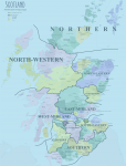
How would this look on a map? Something like this:

Scotland.png

Probably not 100% exact to these lines as the map is from a few decades later, and of course Glasgow needs to be split in three, but I should hope this is a reasonable approximation. So that's one nation (mostly done). I think I might return to Ireland next to try and map that, or perhaps try to tackle Wales next to complete the United Kingdom. Either way, thanks everyone for your help with Scotland, especially @Ileach.

In the meantime, feel free to let me know which Glaswegian constituency you think Bonar Law will be elected from!
 
Well, looks like Bonar Law lived in Helensburgh at the time, if that helps with your seat allocation for this at all.
 
Well, looks like Bonar Law lived in Helensburgh at the time, if that helps with your seat allocation for this at all.
Which puts him in West-Midland if he chooses to run where he lives. I can't help but think he'll want to continue representing a Glasgow constituency though, if only for the prestige. Whichever of the three is most affluent would be my guess. I want to say Northwest, but that's purely a guess on my part.

Bonnie Scotland is one country down, now here's another in the Emerald Isle, complete with a County Down! Good night, everybody!

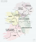
Ireland.png

Preliminary map of Ireland, I can still be swayed on the final borders. It's just been a couple days and I wanted to share an image with all of you. Ireland conveniently displays the religious affiliation of census-takers very prominently for obvious reasons and I might use that to inform boundary changes if need be. Those in charge of such things will want most non-Ulster constituencies to return as many Unionists as possible.

Connaught
Galway - population 192,146 - 3 MIPs
Mayo - population 202,627 - 3 MIPs
Leitrim, Roscommon and Sligo - population 254,862 - 3 MIPs

Munster
Cork - population 404,813 - 5 MIPs
Tipperary and Waterford - population 246,784 - 3 MIPs
Clare, Kerry and Limerick - population 423,478 - 6 MIPs

Leinster
City of Dublin (II. on the map) - population 289,108 - 4 MIPs
Leinster North (counties Dublin, Longford, Louth, Meath, Westmeath) - population 399,470 - 5 MIPs
Leinster South (counties Carlow, Kildare, Kilkenny, Wexford, Wicklow, King's County, Queen's County) - population 461,907 - 6 MIPs

Ulster
City of Belfast (I. on the map) - population 348,965 - 5 MIPs
Antrim and Londonderry - population 256,604 - 3 MIPs
Down - population 289,335 - 4 MIPs
Armagh, Cavan and Monaghan - population 297,111 - 4 MIPs
Donegal, Fermanagh and Tyrone - population 389,336 - 5 MIPs

The objective in this initial pass was making sure all of the constituencies were formed from contiguous and (except for Antrim and Dublin) undivided counties, without crossing any provincial lines, and ensuring that no constituency returned fewer than 3 seats. Thus a few configurations which might seem to fall along more natural religious fault lines had to be bypassed.
 
That Armargh, Cavan and Monaghan one seems more awkward than anything else, but I'm not sure what else you could do there.
 
Been trying to think of single names for the multiname ones. Damn it's hard!
Shannon might work for LRS but the river doesn't touch Sligo and enters Galway. Grr!
 
Been trying to think of single names for the multiname ones. Damn it's hard!
Shannon might work for LRS but the river doesn't touch Sligo and enters Galway. Grr!

Well, there's always going the more generic options in those cases, as much as it is less appealing (and thus can be used as baseline). In that case:
>Clare, Kerry, and Limerick: Munster West
>Tipperary and Waterford: Munster East
>Leitrim, Roscommon, and Sligo: Connaught East
>Armagh, Cavan, and Monaghan: Ulster South
>Armanagh [sic], Donegal, and Tyrone: Ulster West
>Antrim and Londonderry: Ulster North
>Down (yes, I know!): Ulster East

Not as prosaic, but still functional enough.
 
That Armargh, Cavan and Monaghan one seems more awkward than anything else, but I'm not sure what else you could do there.
I agonized over Ulster for quite some time, actually, and I agree, that is one awkward constituency. What's even more frightening? That's probably the best Ulster can look under my general design principles. I can't really link Donegal with Londonderry or Fermanagh without Tyrone because it would look very awkward.

Been trying to think of single names for the multiname ones. Damn it's hard!
Shannon might work for LRS but the river doesn't touch Sligo and enters Galway. Grr!
Well hello, Professor! :) I don't have an objection to poetic names myself, although I can't say it strikes me as very British. Geographical features in particular feel very French...

Well, there's always going the more generic options in those cases, as much as it is less appealing (and thus can be used as baseline). In that case:
>Clare, Kerry, and Limerick: Munster West
>Tipperary and Waterford: Munster East
>Leitrim, Roscommon, and Sligo: Connaught East
>Armagh, Cavan, and Monaghan: Ulster South
>Armanagh [sic], Donegal, and Tyrone: Ulster West
>Antrim and Londonderry: Ulster North
>Down (yes, I know!): Ulster East

Not as prosaic, but still functional enough.
I have to admit I personally consider most of those alternate names for the constituencies.

A lot of people forget Wales. But I haven't! Wales is coming up next!
 
The Gales In Wales Blow Mainly Through The Dales

Welsh autonomy from England was near-nonexistent at the turn of the twentieth century. The Anglican Church had yet to be disestablished as the state religion, the Welsh language was actively suppressed, and home rule was a century away. Virtually no legislation was passed referring to "Wales and Monmouthshire" for its own sake; only when in contrast with "England". Even one of the Welsh counties - Monmouthshire - was widely regarded as part of England proper - or at least, not as part of Wales proper.

The Imperial Federation ITTL takes form in an era when Welsh activists are beginning to seriously agitate for greater autonomy from England. By 1911 IOTL, the Welsh Church Act disestablishing the Anglican Church in Wales was just three years from passage. But in the formation of the Imperial Federation, the most Wales is able to achieve is recognition that Wales is not part of England proper, just an exceptional region treated as part of England for the purposes of tradition, and that recognition as a separate nation with home rule akin to Scotland and Ireland is an objective.

Wales itself is a top-level division within the "English" nation as most of its counties are insufficiently populous to support 3 MIPs, so dividing Wales into loose "regions" comprising multiple counties seems more appropriate... in most cases. Counting Wales as a separate entity, it returns either 23 MIPs (not counting Monmouthshire) or 27 MIPs (counting Monmouthshire). Either way, this means that Wales forms the fourth-smallest delegation to the Assembly, after Newfoundland, New Zealand, and South Africa - though South Africa has a much larger non-voting population.

Wales has 13 counties (including Monmouthshire), and three county boroughs in 1901: Cardiff, Swansea, and Newport. A fourth, Merthyr Tydfil, was created in 1908, but the 1901 census treated it as part of Glamorganshire, and recorded a population of 69,228.


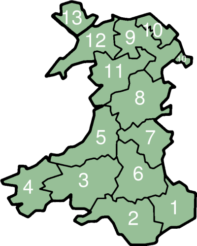
WalesTradNumbered.png


  1. Monmouthshire (+ Newport) - 230,800 - 4 MIPs. Conveniently, Monmouthshire is one of just two Welsh counties (the other being Glamorganshire) which can support its own constituency, and therefore it does. Newport, despite county borough status, did not elect MPs IOTL until 1918, and it is insufficiently populous to do so on the Imperial level anyway.
  2. Glamorganshire (+ Cardiff, Swansea, and Merthyr Tydfil) - 860,026 - 11 MIPs. Returning almost half of the 27 MIPs in the Welsh delegation, Glamorganshire sadly lacks an urban centre sufficiently large to form a constituency of its own. (Cardiff has 164,420 people and would elect 2 MIPs on its own.) This means Glamorganshire has to be divided. As in England, if possible we will want to use the (contemporary, in this case) UK Parliamentary constituencies as guidelines. Glamorganshire looked like this from 1885 to 1918:
    Glamorganshire.png
  3. Carmarthenshire - 135,326 - 2 MIPs.
  4. Pembrokeshire - 87.910 - 1 MIP.
  5. Cardiganshire - 61,076 - 1 MIP.
  6. Brecknockshire - 54,211 - 1 MIP.
  7. Radnorshire - 23,263 - 0 MIPs. Yes, another Rutland.
  8. Montgomeryshire - 54,892 - 1 MIP.
  9. Denbighshire - 131,588 - 2 MIPs.
  10. Flintshire - 81,490 - 1 MIP.
  11. Merionethshire - 48,774 - 0 MIPs, rounded down from 1 MIP due to rounding errors
  12. Carnavonshire - 125,669 - 2 MIPs.
  13. Anglesey - 50,590 - 1 MIP. Although the Isle of Wight (also with 1 MIP) will likely form its own single-member constituency, I doubt the same status will be awarded to Ynys Mon.
How to divide Wales into multiple-county constituencies? The only administrative divisions of Wales that comprises multiple counties prior to the 20th century I could find were those based on the Court of Great Sessions, which divided the 12 counties (excluding Monmouth) into four circuits of three counties each. These circuits ceased to exist in 1830. Nevertheless, this is how Wales would look if we used those lines (and their names):

Chester - (Denbighshire, Flintshire, and Montgomeryshire) - population 267,970 - 4 MIPs
North Wales - (Anglesey, Carnavonshire, and Merionethshire) - population 225,033 - 3 MIPs
Brecon - (Brecknockshire, Glamorganshire, and Radnorshire) - population 937,500 - 12 MIPs
Carmarthen - (Cardiganshire, Carmarthenshire, and Pembrokeshire) - population 284,312 - 4 MIPs

Honestly, in three cases, these lines make for excellent constituencies. By serendipity (especially considering the circuits were formed in the mid-sixteenth century) the populations are relatively equal. The problem is Glamorganshire - it is too populous even on its own, and separating it from the other two counties leaves a constituency (Brecknockshire and Radnorshire) which would return only 1 MIP between them. The most logical solution is appending these two counties (6+7 on the map) to one of the two contiguous circuit constituencies - either Carmarthen (3+4+5) for a "Mid-Wales" which would have 5 MIPs or Chester (8+9+10) for an "East Wales" which would have 4 MIPs.

With these topics to ponder I will open the discussion to the forum.
 
I think I'd probably group Brecon and Radnor with Carmarthen- it's both a rough grouping of modern Dyfed-Powys, and also (to be cynical) helps pull that away from being quite so much of a 'Welsh' seat.

As is, North Wales is basically the really Welsh bit, Carmarthen-Brecon is probably going to be a two-two split and the rest will be more English in tone.
 
I have to admit I personally consider most of those alternate names for the constituencies.
It is worth noting that the ROTPA 1885 didn't actually provide single names for most of the county divisions; they were generally referred to as "the [cardinal direction] or [principal town] Division of [county]". So for instance, the Northern or Biggleswade Division of Bedfordshire would be referred to as North Bedfordshire, Bedfordshire North, Bedfordshire Northern Division, Biggleswade Division or Biggleswade in different contexts.
 
Capital work btw. I'd question the apportionment for South Africa, I think the British would be the sort to just run over any notion of apportionment following franchise size - possibly not to the tune of letting it follow population size, but something about it still feels... off.
 
In light of the 25 likes I've received over the past two days I feel obliged to revive this thread! Sorry about the disappearing act, everyone. Life took me on a detour but everything is fine and I really ought to come back and take advantage of this renewed interest, yes?

I think I'd probably group Brecon and Radnor with Carmarthen- it's both a rough grouping of modern Dyfed-Powys, and also (to be cynical) helps pull that away from being quite so much of a 'Welsh' seat.

As is, North Wales is basically the really Welsh bit, Carmarthen-Brecon is probably going to be a two-two split and the rest will be more English in tone.
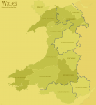
I've decided to go along with this. Here is an outline of Wales (excluding the detail of Glamorganshire, which is divided into three constituencies):

Wales.png

Apart from the three Glamorganshire constituencies and Monmouthshire, I've tentatively decided to use geographical designations for the other constituencies. Therefore the "North Wales" constituency is now called North West Wales. The "Chester" constituency obviously needs to be renamed, which it is to North East Wales. The new "Dyfed-Powys" constituency, with a population of 361,786 and which returns 5 MIPs (the largest constituency in Wales), is called Mid Wales. As for the three Glamorganshire constituencies, they'd have to be drawn as much along the 1885-1918 Parliamentary constituency lines as possible given the lack of any other boundaries above the borough level. My thinking is one constituency centred on each of the three borough towns in the county. I'm thinking they'd be named directly for the borough town each one contains despite also taking in a great deal of rural territory, and therefore Swansea, Merthyr Tydfil, and Cardiff would be the names. My guess is the Cardiff constituency would also take in most of the coastal south of the county, which is more genteel and amenable to the Conservatives. This leaves the Merthyr Tydfil seat to anchor the coalfields of the north and east, and (of course) Swansea capturing the west. I might have to do more digging on the county level in Glamorganshire for more exact borders, but it makes no sense for the constituencies not to be 4-4-3 (for a total of 11) in size. Swansea and the other western settlements for 4, Cardiff and the affluent southern villages for 4, Merthyr Tydfil and all those coal mines for 3.

It is worth noting that the ROTPA 1885 didn't actually provide single names for most of the county divisions; they were generally referred to as "the [cardinal direction] or [principal town] Division of [county]". So for instance, the Northern or Biggleswade Division of Bedfordshire would be referred to as North Bedfordshire, Bedfordshire North, Bedfordshire Northern Division, Biggleswade Division or Biggleswade in different contexts.
That sounds eminently British. In Canada, generally electoral districts are named entity first, followed by cardinal direction; most of these were originally based on counties. It's much more uniform than the UK in that respect. It's very fortunate that Ontario will only return 28 MIPs, since many Ontarian counties are named after English and Scottish counties and there would probably be a lot of repetition otherwise; one solution were it necessary might be an Ontario constituency called Oxford North vs. the English constituency of North Oxfordshire, for example.

Capital work btw. I'd question the apportionment for South Africa, I think the British would be the sort to just run over any notion of apportionment following franchise size - possibly not to the tune of letting it follow population size, but something about it still feels... off.
Thank you! In my view Canada is the country that pushes for representation by population, because it's fundamental to how Canadian legislators are elected and had been, by that point, for over 60 years. (Right as soon as the population of English Canada outnumbered that of French Canada.) So the solution of counting only the "civilized" population of South Africa strikes everyone (except for the disenfranchised majority of South Africa, of course) as a smashing compromise: it keeps the size of the SA delegation fairly low (barely larger than tiny Newfoundland and New Zealand, and much smaller than the less populous Australia, let alone Canada) but still gives the Boers/Afrikaners a proportionate say in things. (That's also going to be a demand from without - one of the reasons Anglo-German relations went so bad in the early 20th century is because the Germans did not like Britain annexing the Boer republics. The other powers will be mollified by the Afrikaners having a voice in the Imperial government even as they blithely ignore millions of Africans - in South Africa! - being denied the same.)

With Wales (mostly) done and Scotland and Ireland as well, there we have the Celtic Nations. (Cornwall is one constituency covering the whole county. There. That's all of them.) Among the luminary MIPs who are likely to sit in the 1st Assembly of the Parliament of the Imperial Federation representing a constituency for Wales is, of course, David Lloyd George, one of the three MIPs for North West Wales.
 
It's very fortunate that Ontario will only return 28 MIPs, since many Ontarian counties are named after English and Scottish counties and there would probably be a lot of repetition otherwise; one solution were it necessary might be an Ontario constituency called Oxford North vs. the English constituency of North Oxfordshire, for example.
I assume we'll get a lot of em dashes then.
 
I assume we'll get a lot of em dashes then.
Much as I'd like to avoid them, it's probably inevitable in future decades.

Speaking of Canada, I've finally made a breakthrough which will allow me to map Ontario and Quebec (as previously noted, all other provinces will each comprise a single constituency). At this time, Canadian census divisions were coterminous with federal electoral districts (called "ridings" in Canadian parlance). I've found old census information on the Internet Archive and old electoral maps from the period, so I just have to piece everything together. Which may take some time, but at least I have all the building blocks. I might pivot to Ontario next if only because England is somewhat daunting, and I'm not sure where to start - though I'm happy to take suggestions!

Fantastic work, Brainbin. Glad to see that you've come back to this.
Thank you very much! Although I feel I should point out that the underlying maps are not my creation, I borrowed them from Wikipedia. I just drew the thick-line borders. And sometimes type out the new constituency names. (In Georgia.) And apply a colour filter. Just to clear up any confusion. And therefore...

Yay, it's back.
As an alphabet nerd what is that script called?
I have no idea what the script is called. Sorry!

As a fun parlour game while I'm continuing to work on these, feel free to suggest prominent MIPs from your chosen locality. Or debate where they might stand. There are the obvious: Mr Bonar Law, MIP for Glasgow Northwest; Mr Lloyd George, MIP for North West Wales; Messrs Joseph and Austen Chamberlain, MIPs for Birmingham (a seven-seat constituency in my tentative calculation). But then there is the itinerant Mr Winston Churchill, known IOTL as a man with no fixed Parliamentary abode in his early career. I believe that would not be the case ITTL. Though he never represented any constituency in London IOTL, surely we must all agree that's where he truly belongs. And (referring back to page 1) London has a lot of large constituencies which might stick with him through thick and thin, through Conservative and Liberal and maybe even Constitutionalist as the case may be. Which might he choose? He mostly lived in Westminster during this time but that constituency only returns 3 MIPs. Chelsea (which includes Kensington, where he lived late in life IOTL) might be a safer bet, since it returns 7 MIPs.
 
I have no idea what the script is called. Sorry!
ach dammit, that font was so familiar
As a fun parlour game while I'm continuing to work on these, feel free to suggest prominent MIPs from your chosen locality. Or debate where they might stand. There are the obvious: Mr Bonar Law, MIP for Glasgow Northwest; Mr Lloyd George, MIP for North West Wales; Messrs Joseph and Austen Chamberlain, MIPs for Birmingham (a seven-seat constituency in my tentative calculation). But then there is the itinerant Mr Winston Churchill, known IOTL as a man with no fixed Parliamentary abode in his early career. I believe that would not be the case ITTL. Though he never represented any constituency in London IOTL, surely we must all agree that's where he truly belongs. And (referring back to page 1) London has a lot of large constituencies which might stick with him through thick and thin, through Conservative and Liberal and maybe even Constitutionalist as the case may be. Which might he choose? He mostly lived in Westminster during this time but that constituency only returns 3 MIPs. Chelsea (which includes Kensington, where he lived late in life IOTL) might be a safer bet, since it returns 7 MIPs.
Would he not try for his father's seat or successor thereof: Woodstock?
 
The Maple Leaf Forever

Canadian_Red_Ensign_%281868%E2%80%931921%29.svg


The Dominion of Canada is the oldest, largest, and most populous of the British Dominions. As part of my sketches for the formation of the Imperial Federation I have Canada as the laggard, since at the turn of the 20th century it is governed by Sir Wilfrid Laurier, the first of many PMs who sought to distance Canada from her Imperial entanglements. He was only partly successful and IOTL his efforts would ultimately result in his defeat when he pursued trade reciprocity with the United States (how's that for timely?). ITTL, I imagine the 1904 or 1908 elections would result in the election of the Conservatives, led by Sir Robert Borden, who argue in support of the Imperial Federation as Laurier attempts to avoid committing too strongly either way, thus alienating both sides of the debate. The 1901 census reported a population of 5,371,315 for the Dominion of Canada, a larger population than that of Scotland or Ireland. Worth noting in regards to the "civilized peoples" doctrine of representation, 34,481 of these are listed as "Half-Breeds" (Metis) and 93,460 as Indians - which is to say, Aboriginals. (In French they are called sauvages). Interestingly, though the Empire has hundreds of millions of actual Indians, those peoples are not listed in the Census. The only peoples not of European or North American origin to be listed are "Chinese and Japanese" (a surprisingly low 22,050) and "Negroes" (17,437). Chinese-Canadians were granted the franchise in 1898; and only "status Indians" were denied the right to vote; that is, they were denied the franchise on the basis of their nationality, not (technically) their race. Therefore the proportion of the population to be denied the franchise on account of being "insufficiently uncivilized" is probably less than 100,000 - or about 2% of the total population. The Canadian delegation, in the face of feints from the South African delegation eager to reduce Canadian representation within the Imperial Parliament in retaliation for their own self-imposed marginalization, will claim their disenfranchised population to be "negligible", and so the decision will be made to represent Canada within the Parliament as though its entire population were eligible to vote. (A large chunk of these Indians would be Inuit - IOTL these are today legally distinct from the other "First Nations" Aboriginals - who wouldn't be able to vote anyway as the Territories are not represented within the Imperial Parliament, their meagre population (about 46,000 per the 1901 census) divided pro rata amongst the remaining provinces for the purposes of representation.

Taking all this into consideration, the Dominion of Canada, whose top-level divisions are the nine provinces, sends the following delegation of 72 MIPs (a larger delegation than any other realm save for England, with or without Wales) to the Imperial Parliament:

Ontario - population 2,182,947 - 30 MIPs. These thirty MIPs will be divided amongst the combined building blocks formed by the 85 federal electoral districts in use at the time.
Quebec - population 1,648,898 - 22 MIPs. These twenty-two MIPs will be divided amongst the combined building blocks formed by the 65 federal electoral districts in use at the time.
Nova Scotia - population 459,574 - 6 MIPs. Theoretically I could divide the six MIPs amongst two three-member constituencies, which I will investigate upon a more detailed review, but I like the idea of Nova Scotia going with the six-member constituency, not least because I want to potentially return a Gaelic/Celtic Nationalist MP for Nova Scotia (who might seek to ally with his brethren in the British Isles) and the population is still just large enough (with a 1/7 + 1 threshold) for me to do so.
New Brunswick - population 331,120 - 5 MIPs. One of the better chances for a potential Parti Nationaliste du Canada (or the Parti Rouge or les Patriotes, if you like) to return a member from outside of Quebec. Of those 331,120 people, just under 80,000 (about 24%) are listed as having "French" origin in the 1901 census. The electoral threshold is 1/6 + 1, or 16.67%. Game on.
Manitoba - population 255,211 - 4 MIPs. Among those four MIPs likely to be elected is the arch-imperialist Arthur Meighen for the Conservatives/Unionists.
British Columbia - population 178,657 - 2 MIPs. Manitoba just made it over the edge to get to 4; BC fell just short of 3, despite their relatively close populations. Of course, in time, BC will send a much larger delegation to the Imperial Parliament than Manitoba.
Prince Edward Island - population 103,259 - 1 MIP. This province will never send more than one MIP to the Imperial Parliament. In decades to come, this province will be one of the main arguments for shifting Canada's top-level division from provinces to super-provincial "regions" (i.e. the Maritimes). IOTL, in 2016, PEI's population had risen, in over a century, to... 142,907. An increase of 38% in 115 years. In the same timespan, Ontario's population sextupled (616%), Manitoba's population quintupled (501%), and Alberta's population increased fifty-six-fold (5,611%). I will say that, by the reckoning of the 1901 census at least, PEI is duly entitled to its lone MIP.
Saskatchewan - population 93,064 - 1 MIP. Not a province in 1901, it was formed (alongside Alberta) in 1905. The population of the territorial districts that formed Saskatchewan are counted to arrive at this figure.
Alberta - population 72,491 - 1 MIP. See Saskatchewan.
The Territories have a population of 46,094. More than half of this remaining population lives in the newly-formed Yukon Territory, home of the famous Klondike Gold Rush of the late 1890s, where the North-West Mounted Police, or "Mounties", first captured the imagination of American prospectors. These people are not directly represented within the Imperial Parliament, though they are "counted" as part of Canada's overall delegation.

Coming up next, we'll take a look under the hood of Ontario, with a map of the 85 building blocks and how they might form the no more than ten (30 divided by 3 equals 10), and no fewer than five (30 divided by 7 equals 4 2/7, rounded up to 5), "Imperial ridings" we will need.

And that's my outline for Canada. This isn't set in stone; I'm still more than willing to make further tweaks as needed, as indeed some of you will notice I already have done.
 
Last edited:
A Place to Stand, A Place to Grow

Arms_of_Ontario.svg


Ontario was one of the four charter provinces of the Dominion of Canada upon Confederation in 1867, along with Quebec, Nova Scotia, and New Brunswick. Since Confederation, it has always been the most populous of the provinces, a trend which continued in 1901 when a population of 2,182,947 was recorded. (Thus Ontario is home to two-fifths of Canada's total population.) Though largely Anglophone, a sizeable Francophone minority populates Northern and Eastern Ontario, though this population should not be overstated; the census records 1,732,144 persons of British origin, against 158,671 of French origin. However, it also records 203,319 persons of German origin, the largest minority group in Ontario. The next-largest minority group are the Dutch-Ontarians, with 23,280 souls. The census of 1901 reported population according to the electoral districts established in 1895; however, a new electoral map consisting of 85 ridings was drawn based on these new figures in 1903, and it is this map I will be using as the basis of my "blueprint" for Ontario. In those days, new electoral districts were drawn into a handy tome called the Electoral Atlas for the Dominion of Canada, several of the editions of which have been archived online. I will be using the 1906 edition of this atlas, which conveniently lists the population for each riding per the 1901 census, redistributed to follow the new lines:

.item


The 85 ridings, and their population at the time of the 1901 census, are as follows:

  1. Algoma East - 25,211
  2. Algoma West - 17,894
  3. Brant - 18,273
  4. Brantford - 19,867
  5. Brockville - 18,721
  6. Bruce North - 27,424
  7. Bruce South - 31,596
  8. Carleton - 24,380
  9. Dufferin - 21,036
  10. Dundas - 19,757
  11. Durham - 27,570
  12. Elgin East - 17,901
  13. Elgin West - 25,685
  14. Essex North - 28,789
  15. Essex South - 29,955
  16. Frontenac - 24,746
  17. Glengarry - 22,131
  18. Grenville - 21,021
  19. Grey South - 21,053
  20. Grey North - 24,874
  21. Grey East - 23,663
  22. Haldimand - 21,233
  23. Halton - 19,545
  24. Hamilton East - 24,000
  25. Hamilton West - 28,634
  26. Hastings West - 32,505
  27. Hastings East - 26,786
  28. Huron East - 19,227
  29. Huron West - 19,712
  30. Huron South - 22,881
  31. Kent East - 25,328
  32. Kent West - 31,866
  33. Kingston - 19,788
  34. Lambton East - 26,919
  35. Lambton West - 29,723
  36. Lanark North - 17,236
  37. Lanark South - 19,996
  38. Leeds - 19,254
  39. Lennox and Addington - 23,346
  40. Lincoln - 30,552
  41. London - 37,976
  42. Middlesex North - 16,419
  43. Middlesex East - 20,228
  44. Middlesex West - 18,079
  45. Muskoka - 20,971
  46. Nipissing - 28,309
  47. Norfolk - 29,147
  48. Northumberland East - 20,495
  49. Northumberland West - 13,055
  50. Ontario North - 18,390
  51. Ontario South - 22,018
  52. Ottawa (City of)* - 57,640
  53. Oxford North - 25,644
  54. Oxford South - 22,760
  55. Parry Sound - 24,936
  56. Peel - 21,475
  57. Perth North - 29,256
  58. Perth South - 20,615
  59. Peterboro East - 16,291
  60. Peterboro West - 20,704
  61. Prescott - 27,035
  62. Prince Edward - 17,864
  63. Renfrew North - 24,556
  64. Renfrew South - 27,676
  65. Russell - 35,166
  66. Simcoe North - 26,071
  67. Simcoe South - 26,399
  68. Simcoe East - 29,845
  69. Stormont - 27,042
  70. Thunder Bay and Rainy River - 28,987
  71. Toronto East - 40,097
  72. Toronto West - 44,991
  73. Toronto Centre - 43,861
  74. Toronto North - 40,983
  75. Toronto South - 38,108
  76. Victoria - 38,511
  77. Waterloo North - 27,124
  78. Waterloo South - 25,470
  79. Welland - 31,588
  80. Wellington North - 26,120
  81. Wellington South - 29,526
  82. Wentworth - 26,818
  83. York North - 22,419
  84. York Centre - 21,505
  85. York South - 20,699
* Note that the City of Ottawa returned two MPs at this time.

Many of my British readers will notice the very large number of counties named for one of two sources: either English or Scottish counties and regions, or 19th-century British political figures. You may also note that many electoral districts consist of parts, or ridings, of individual counties, hence the popular term for them in the Canadian lexicon. I have an additional map I've created which does recombine these ridings into their whole counties, or as close an approximation thereto as possible (some riding boundaries emphatically do not correspond with county lines, for reasons which I'm sure made sense to those in charge), and these can form the basis of the multi-member constituencies whose 30 total MIPs will represent Ontario in the Imperial Parliament. I've drawn one possible orientation already, but I don't want to put the cart before the horse and I thought I would provide you all with some background before I jumped in, especially since this gives me the opportunity to open the floor to input.
 
Last edited:
Back
Top