Fair, I just don't recall seeing it before on your maps. Did you ever do it on those Imperial German ones, seeing as they also had the 2-round system?I’ve been doing this for a very long time now, but yes, I agree it makes a lot of sense.
-
Hi Guest!
The costs of running this forum are covered by Sea Lion Press. If you'd like to help support the company and the forum, visit patreon.com/sealionpress
You are using an out of date browser. It may not display this or other websites correctly.
You should upgrade or use an alternative browser.
You should upgrade or use an alternative browser.
Max's election maps and assorted others
- Thread starter Ares96
- Start date
- Location
- Das Böse ist immer und überall
- Pronouns
- he/him
The ones I've put up here, years and years ago, didn't have margins of victory, they were essentially based on your very old British election maps. I have a new series on the way, and those do use that shading system, but since the information on Wikipedia is incomplete, I would only be able to finish them by getting hold of @iainbhx's books (or different copies of the same work) again.Fair, I just don't recall seeing it before on your maps. Did you ever do it on those Imperial German ones, seeing as they also had the 2-round system?
I was going to say, I had a memory they were winner-only and the data was incomplete.The ones I've put up here, years and years ago, didn't have margins of victory, they were essentially based on your very old British election maps. I have a new series on the way, and those do use that shading system, but since the information on Wikipedia is incomplete, I would only be able to finish them by getting hold of @iainbhx's books (or different copies of the same work) again.
Ironically I made the UK ones you're talking about by taking those by David Boothroyd and Al "Sibboleth" that were majority-margin, and then converting them to winner-only "because nobody cares about margin of victory". How I thought back in 2009...
shearsforest
The Authentic Shears
- Location
- Test Domain
- Pronouns
- he/him
I checked — they're Discord images, and Discord wiped out the ability to host images on their platform just recently. So you can still share images within Discord, but not outside of it.Max, not sure what's happened but some of the older maps (like the Austro-Hungarian electoral results, or the A-H demographic map) are now missing, just so you know.
- Location
- Das Böse ist immer und überall
- Pronouns
- he/him
I’m not surprised by that, Discord’s image hosting was always too good to be true. Unfortunately, the specific issue with the A-H maps was that they were too big to host directly on here, so I’ll have to find a different solution if I want them to be visible again.
I’m not surprised by that, Discord’s image hosting was always too good to be true. Unfortunately, the specific issue with the A-H maps was that they were too big to host directly on here, so I’ll have to find a different solution if I want them to be visible again.
Honestly, I think it's worth uploading on Wikipedia.
Does the Deviantart not work for this?I’m not surprised by that, Discord’s image hosting was always too good to be true. Unfortunately, the specific issue with the A-H maps was that they were too big to host directly on here, so I’ll have to find a different solution if I want them to be visible again.
Oslo, parish history
- Location
- Das Böse ist immer und überall
- Pronouns
- he/him
Once again I've been waylaid by something that just kind of happened to be there.
Medieval Oslo had multiple churches, of which St. Hallvard's Cathedral was the most prominent, but after it burned down in 1624 (the city, that is - the cathedral was actually one of the few buildings to survive the fire), King Christian IV ordered it moved to a new location west of where it had been and modestly renamed it Christiania. The new city had a modern, right-angled street grid, a large military fortress at Akershus that doubled as the seat of government (kind of a kremlin, when you think about it), and a single large church at its single town square, which was named "Vor Frelser" ("Our Saviour" in Danish) as a reminder not to try any of that Papist nonsense around here.
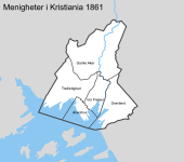
Christiania remained a small city for the next two hundred years, populated largely by royal officials and their families, and so Vor Frelser was enough to fulfil the spiritual needs of the townspeople until 1858, when the city's land area was extended and it was determined that a second church was needed. Again, a suitably un-popish name was chosen for it, this time "Trefoldighed" ("Trinity"), and the city was split down the middle along Kongens gate, with Trefoldighed handling the west and Vor Frelser (which remained the seat of the Bishop of Oslo) the east. Trefoldighed took in some of the newly-annexed lands to the west, but in the north and east, a large area remained under Aker parish (the rural parish that surrounded Christiania) until arrangements could be made in 1861. The 1858 expansion had actually placed the old Aker church (Oslo's oldest building, dating back to the 12th century) within the city limits, and so the northern outskirts of the city were formed into the parish of "Gamle Aker" ("Old Aker") with the old church as its parish church. The eastern areas became the Grønland parish, simply named for the area the church was in, while the rural parish was split into a western and an eastern part, with each getting its own church.
By this time, Christiania was becoming Norway's industrial capital as well as its administrative one, and its population very soon outstripped what these four parishes could handle. In 1874, every parish except Grønland was split in half, with the eastern part of Gamle Aker forming Paulus parish, the north of Vor Frelser becoming Jakob, and the south-east of Trefoldighed becoming Johannes. Apparently naming churches after the apostles was fine in a Protestant country now. O tempora, o mores.
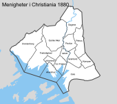
In 1878, there followed a second expansion of the city limits, necessary because it was running out of land to build new housing on. Three new parishes were formed out of these annexed areas: Uranienborg in the west, Kampen in the east and Petrus in the northeast (making a nice companion to Paulus). Around the same time, both Gamle Aker and Grønland were split, with Grønland's southern part forming the new parish of Oslo (named after the medieval town once located on its territory) while the north of Gamle Aker combined with some of the newly-annexed land to form the parish of Sagene. Aside from Petrus, all of these were simply named after the geographic areas they covered, and this would continue to be the dominant pattern going forward.
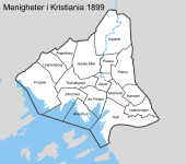
In less than a decade, Christiania (now often spelled Kristiania, in a slightly "Norwegianised" form) had gone from four to twelve parishes. However, its population kept growing, and now it was the west that needed attention. Uranienborg, Gamle Aker and Trefoldighed were all quite large compared to their eastern neighbours, and while the west was also less densely populated (due to being much, much wealthier), the large parishes were still presenting administrative issues. In 1897, Trefoldighed parish lost territory on almost all sides, and Uranienborg was split in three, with the northern areas becoming Fagerborg parish and the south becoming Frogner. Two years later, Oslo and Kampen gave up territory to the new parish of Vaalerengen, which covered a working-class neighbourhood that had been unacceptably far from either church.
This was the state of things when Norway became an independent state in 1905, and continued unchanged until 1916, when they decided to do some weird shit. A total of six new parishes were created, mainly in working-class areas, and while a couple of them made sense (splitting Sagene was probably inevitable, since its church was west of the river while most of the population was east of it), some of the others were just a few blocks each, and it honestly surprises me that people ever thought they'd be viable.
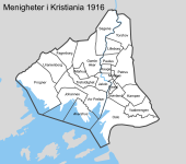
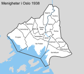
1916, then, represents the peak concentration of parishes in the city, and from here on, at least for the city centre, parishes are going to get merged rather than split. The only 1916 creations with any real future were Markus, which was later expanded to cover all of Gamle Aker west of Ullevålsveien, and Torshov, which was far from the smallest parish in the city to begin with. By 1938, all four of the others had been suppressed, although some carried on as subunits of their new-old parishes. Johannes was also suppressed in 1926, and in 1938 the Akershus garrison church also lost its parish status, with the result that Vår Frelser (now respelled to fit the modern Bokmål standard) now covered the bulk of the city centre. And of course, in 1925, the city was renamed, taking back its pre-Danish name Oslo. To avoid confusion, the Oslo parish was rechristened "Gamlebyen" ("Old Town") at the same time.
Medieval Oslo had multiple churches, of which St. Hallvard's Cathedral was the most prominent, but after it burned down in 1624 (the city, that is - the cathedral was actually one of the few buildings to survive the fire), King Christian IV ordered it moved to a new location west of where it had been and modestly renamed it Christiania. The new city had a modern, right-angled street grid, a large military fortress at Akershus that doubled as the seat of government (kind of a kremlin, when you think about it), and a single large church at its single town square, which was named "Vor Frelser" ("Our Saviour" in Danish) as a reminder not to try any of that Papist nonsense around here.
Christiania remained a small city for the next two hundred years, populated largely by royal officials and their families, and so Vor Frelser was enough to fulfil the spiritual needs of the townspeople until 1858, when the city's land area was extended and it was determined that a second church was needed. Again, a suitably un-popish name was chosen for it, this time "Trefoldighed" ("Trinity"), and the city was split down the middle along Kongens gate, with Trefoldighed handling the west and Vor Frelser (which remained the seat of the Bishop of Oslo) the east. Trefoldighed took in some of the newly-annexed lands to the west, but in the north and east, a large area remained under Aker parish (the rural parish that surrounded Christiania) until arrangements could be made in 1861. The 1858 expansion had actually placed the old Aker church (Oslo's oldest building, dating back to the 12th century) within the city limits, and so the northern outskirts of the city were formed into the parish of "Gamle Aker" ("Old Aker") with the old church as its parish church. The eastern areas became the Grønland parish, simply named for the area the church was in, while the rural parish was split into a western and an eastern part, with each getting its own church.

By this time, Christiania was becoming Norway's industrial capital as well as its administrative one, and its population very soon outstripped what these four parishes could handle. In 1874, every parish except Grønland was split in half, with the eastern part of Gamle Aker forming Paulus parish, the north of Vor Frelser becoming Jakob, and the south-east of Trefoldighed becoming Johannes. Apparently naming churches after the apostles was fine in a Protestant country now. O tempora, o mores.
In 1878, there followed a second expansion of the city limits, necessary because it was running out of land to build new housing on. Three new parishes were formed out of these annexed areas: Uranienborg in the west, Kampen in the east and Petrus in the northeast (making a nice companion to Paulus). Around the same time, both Gamle Aker and Grønland were split, with Grønland's southern part forming the new parish of Oslo (named after the medieval town once located on its territory) while the north of Gamle Aker combined with some of the newly-annexed land to form the parish of Sagene. Aside from Petrus, all of these were simply named after the geographic areas they covered, and this would continue to be the dominant pattern going forward.

In less than a decade, Christiania (now often spelled Kristiania, in a slightly "Norwegianised" form) had gone from four to twelve parishes. However, its population kept growing, and now it was the west that needed attention. Uranienborg, Gamle Aker and Trefoldighed were all quite large compared to their eastern neighbours, and while the west was also less densely populated (due to being much, much wealthier), the large parishes were still presenting administrative issues. In 1897, Trefoldighed parish lost territory on almost all sides, and Uranienborg was split in three, with the northern areas becoming Fagerborg parish and the south becoming Frogner. Two years later, Oslo and Kampen gave up territory to the new parish of Vaalerengen, which covered a working-class neighbourhood that had been unacceptably far from either church.

This was the state of things when Norway became an independent state in 1905, and continued unchanged until 1916, when they decided to do some weird shit. A total of six new parishes were created, mainly in working-class areas, and while a couple of them made sense (splitting Sagene was probably inevitable, since its church was west of the river while most of the population was east of it), some of the others were just a few blocks each, and it honestly surprises me that people ever thought they'd be viable.

1916, then, represents the peak concentration of parishes in the city, and from here on, at least for the city centre, parishes are going to get merged rather than split. The only 1916 creations with any real future were Markus, which was later expanded to cover all of Gamle Aker west of Ullevålsveien, and Torshov, which was far from the smallest parish in the city to begin with. By 1938, all four of the others had been suppressed, although some carried on as subunits of their new-old parishes. Johannes was also suppressed in 1926, and in 1938 the Akershus garrison church also lost its parish status, with the result that Vår Frelser (now respelled to fit the modern Bokmål standard) now covered the bulk of the city centre. And of course, in 1925, the city was renamed, taking back its pre-Danish name Oslo. To avoid confusion, the Oslo parish was rechristened "Gamlebyen" ("Old Town") at the same time.

- Location
- Derbyshire
That 1916 split truly is bizarre.
Finland 1880 (languages)
- Location
- Das Böse ist immer und überall
- Pronouns
- he/him
As I'm sure you know, one of the long-term projects I'm working on at the moment is a TL where the separation of Finland from Sweden in 1809 doesn't happen (link in signature, or also here if you're on mobile). I've been doing some historical research to determine what the situation was east of the sea before the split, as it will help me figure out where it goes from there (i.e. how bad is the Ireland comparison exactly), and one of the things that led me to was the fact that the first modern Finnish census to count native languages was that of 1880, which placed the proportion of Swedish-speakers at 14.3%. This most likely represented a slight dip from the peak during the 18th century, but most of that was due to the Finns having a higher rate of population growth rather than an actual decline in the Swedish population. In absolute numbers, the population of Swedish-speakers in 1880 was 294,876, which is almost the same as today (287,933), and slightly below the mid-20th-century peak of around 350,000. Of course, the Finnish-speaking population has since grown from 1.7 million in 1880 to just under five million today, and this explains why the proportion of Swedish-speakers has now shrunk to around 5%.
I was in fact able to find the 1880 census reports on Doria, the Finnish government's document database, and that has in turn allowed me to make a map of Finland by language spoken as of the first reliable data on the topic. The result is, well, a bit dull actually. You might expect that a Swedish population that's almost three times the percentage that it is now would be more geographically spread out than it is now, but this wasn't really the case. Some Swedish-speaking areas were Fennicised during the early modern period, notably the coast around Fredrikshamn, the northwest corner of Satakunta and some of the countryside around Åbo, but after that there was very little population movement. This was actually encouraged by the Church, which resisted efforts by the 18th-century Swedish state to spread the Swedish language because rural priests didn't want to have to deal with bilingual congregations, and the result of this is evident in Ostrobothnia in particular. Vasa and Karleby had small Finnish minorities in 1880, and Uleåborg and Brahestad had very small surviving Swedish elite groups, but other than them, every single parish in the entire region was more than 90% one language or the other. Nyland was a bit more diverse, with several mixed parishes along the language border. Some of these remain bilingual today, like Sjundeå/Siuntio and Kyrkslätt/Kirkkonummi, but the majority are now entirely or almost entirely Finnish-speaking. This includes most of the Helsinki region, but also areas like Lohja/Lojo and Pyhtää/Pyttis, where little trace remains of their Swedish heritage today.
The main difference between 1880 and today, generally speaking, is that urban areas were much more Swedish then than they are now. Helsinki had a small Swedish majority in 1880, Vasa (then called Nikolaistad) had a compact one, and even Åbo still had a strong Swedish minority. Most other cities in Finland had some Swedish presence, notably Viborg/Viipuri with around 20% and Björneborg/Pori with around 14%, but even a place like Tammerfors/Tampere with its 6% Swedish population held on to its bilingual street signs until the 1920s and still has a Swedish school. These "language islands" (språköar) are, of course, the product of the traditional Swedish-speaking administrative and commercial elite, and tended to be very culturally distinct from the rural Swedish communities which often had more in common with their Finnish-speaking neighbours - even given the Republika Srpska-like isogloss in Ostrobothnia.
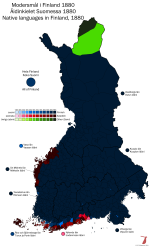

Very interesting Max. Of course the urban-rural divide makes the Swedish-speakers look like an even smaller proportion than they are, but I imagine there aren't exactly many 1880 census Finnish cartogrammes knocking about...
- Location
- Das Böse ist immer und überall
- Pronouns
- he/him
I do have raw population figures as well, so if I knew slightly more about GIS than I do, it would be possible to make one.Very interesting Max. Of course the urban-rural divide makes the Swedish-speakers look like an even smaller proportion than they are, but I imagine there aren't exactly many 1880 census Finnish cartogrammes knocking about...
prime-minister
Average electoral map enjoyer
- Location
- Cambridge
- Pronouns
- They/them
Very nice work as always. I somehow didn't actually realise there was a majority-Sami speaking part of Finnish Lapland, though apparently Inari is overwhelmingly Finnish nowadays.snip
I'd be interested to see, if or when you get to the early 20th century, whether the Tsar's Russification efforts had any significant impact on linguistic demographics? I get the impression from my cursory understanding of Finnish politics of the time that they were so fiercely resisted that they didn't really, but seeing how Viborg/Viipuri was overwhelmingly Finnish back then, it'd be interesting to see if Russia seizing it after WWII led to complete demographic change like modern-day Kaliningrad or if it had an existing Russian minority there because of Russification like in the Baltics.
- Location
- Das Böse ist immer und überall
- Pronouns
- he/him
I have no plans to do additional censuses, given how little things have changed I doubt it would be very interesting. To answer your question, the “Russification” policies pursued under Bobrikov weren’t primarily about making Finns speak Russian or moving Russians into Finland, but rather integrating Finland more fully into the Russian system and reducing its level of autonomy within the Russian Empire. Part of that was an attempt to make Russian the official language, but that was never fully carried out, for the same reason it wasn’t done in 1809 - there simply weren’t enough people who knew Finnish legal and administrative systems well enough to run the bureaucracy while also being able to speak Russian.I'd be interested to see, if or when you get to the early 20th century, whether the Tsar's Russification efforts had any significant impact on linguistic demographics? I get the impression from my cursory understanding of Finnish politics of the time that they were so fiercely resisted that they didn't really, but seeing how Viborg/Viipuri was overwhelmingly Finnish back then, it'd be interesting to see if Russia seizing it after WWII led to complete demographic change like modern-day Kaliningrad or if it had an existing Russian minority there because of Russification like in the Baltics.
There was in fact a small uptick in the Russian population following independence, due to White emigration from what was now the Soviet Union. I believe this group was largely concentrated in Helsinki and Viborg, but never seriously affected the demographic balance of either city. The post-war resettlement of the Karelian Isthmus was indeed done almost from scratch, which is why most of the towns and villages there were given new, very Soviet-sounding names. Ladoga Karelia was slightly different, being part of the Karelo-Finnish ASSR (which, fun fact, was actually led by a native Swedish-speaker named Edvard Gylling for a good chunk of the interwar period), but even there most of the population was replaced, they just let the towns keep their names and paid lip service to Karelian cultural traditions.
Melbourne tram history
- Location
- Das Böse ist immer und überall
- Pronouns
- he/him
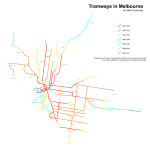
Here's a quick thing I mostly did for my own reference: the tram lines in Melbourne coloured by date of opening. As the key on the map says, this refers to the first time a tram line opened over a given alignment - a lot of them were originally built as either horse or cable tramways and have since been reconstructed, while others have replaced older alignments over similar routes (the Queens Way and Melbourne Park alignments, for example) which aren't shown here.
- Location
- Das Böse ist immer und überall
- Pronouns
- he/him
And a quick test to see if Discord image linking works or not:


shearsforest
The Authentic Shears
- Location
- Test Domain
- Pronouns
- he/him
Wait... didn't Discord disable that functionality a while ago?And a quick test to see if Discord image linking works or not:

Sort of. What they did was make image hosting temporary, so the link will expire after a time. If you then go back to Discord and find the original image after that, it will be re-hosted on a new link. I think an image link lasts 30 or 60 days, something like that.Wait... didn't Discord disable that functionality a while ago?
Los Angeles Railway, 1949
- Location
- Das Böse ist immer und überall
- Pronouns
- he/him
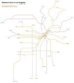
Uploading a version without the background directly onto here, just so it won't confuse future readers. Also featuring car barns - and no, you're not mistaken, there was no Division 2. Or to be more precise, Division 2, which was at 54th and San Pedro, closed in 1932, partly because there was redundant capacity in the other divisions and partly because it was in a really stupid location, with only one line (the S car) directly connected to it and long transits required to get to any other line.
