• Hi Guest!

    The costs of running this forum are covered by Sea Lion Press. If you'd like to help support the company and the forum, visit patreon.com/sealionpress

Max's election maps and assorted others

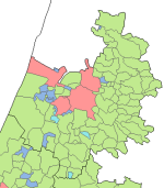
Ramla subdistrict, for its part, was home to Rishon LeZion, the oldest Zionist settlement in Palestine (hence the name, which is Hebrew for "First to Zion"), as well as the fellow Zionist new town of Rehovot, and the older towns of Ramla and Lydda which had majority-Arab populations (pretty much entirely so in Lydda's case). Lydda is where the Jaffa-Jerusalem railway intersected the main north-south line, and this transport link made the region one of the most urbanised in Palestine, also helped by the relatively-fertile countryside that surrounded it. Although the district was about a quarter Jewish in 1945, most of this was in the urban areas, and the countryside was predominantly (77% of land area) in Arab hands aside from a few moshavim around Rehovot and a couple of isolated kibbutzim. This would change dramatically in 1948.

1697227633713.png
 
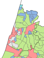
Jaffa subdistrict was the most populous in the Mandate, with some 400,000 residents, of whom about 72% were Jewish - the only subdistrict with an absolute majority of Jews. The most prominent Jewish settlement in the region, of course, was Tel Aviv, which was directly north of the much older, predominantly Arab city of Jaffa. The two would be merged into a single city in 1950, along with a number of surrounding municipalities, and this makes it a bit hard to determine what exactly the divisions were at this point in time. The map shows several different kinds of boundary line in the region, none of which are explained by the key, although I'm sure one of the several hundred other maps in the series would be clearer. Either way, while there was a large bloc of moshavim around Herzliya and Magdiel (later Hod HaSharon) in the north of the subdistrict, the majority of rural land was in Arab hands just as in Ramla.

1697320614441.png
 
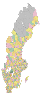
Sweden 1863 (K)
So here's something unrelated to the previous (take a shot, everyone): I've taken my very best shot at bringing the big basemap of Swedish parishes back to 1863, the year the Municipal Ordinances came into effect and civil and ecclesiastical administration was separated. These laws applied throughout the country except in Lapland, where the sparse and "uncivilised" nature of the local population meant it took another eleven years before the reform was implemented.

The Ordinances created 2,358 rural municipalities, most of which were derived from one whole Church of Sweden parish, although there were a few exceptions where small parishes (mainly in Västergötland and Östergötland) were merged to make administration more efficient. Even then, most municipalities were very small, counting only a few hundred residents - this wasn't that big of a deal, since local municipalities had limited powers in rural areas and mainly administered poor relief. There was no planning outside of towns at this point, roads were maintained by local landowners, and schools continued to be run by the Church until 1930. To handle issues too wide-ranging or costly for the local municipalities, mainly agricultural aid and public health (and later on also hospitals), a related ordinance set up county councils (landsting) which were elected by the same census franchise as the local municipalities, had a number of councillors that were in fixed proportions to population (one per 5,000 urban residents and 7,000 rural residents, at least later on), and would additionally serve as electors for the First Chamber of the Riksdag when that was created in 1866.

There were also a large number of very illogical and impractical boundaries still in place at this point, some of which were exclaves (mainly in Dalarna and other sparsely-settled areas), but most of which were to do with parishes being split between multiple hundreds, and in some cases, multiple counties. The south of Sweden was particularly notorious for this, with boundary-crossing parishes practically being the norm in both Scania and Småland. Småland even has a dialect word (skate - that's pronounced with two syllables) meaning "a part of a parish that's separated from it by a higher administrative boundary". One of these - the Skårdals skate area directly across the river from Kungälv, just north of Gothenburg - had even been in a separate country from the main part of the parish until 1658, when Bohuslän belonged to Norway. Residents of the area were said to be "Norwegian in body and Swedish in soul", since they paid taxes to the Norwegian crown but went to church across the border in Sweden.

What about urban areas, then? Well, the 88 towns in Sweden had already had some form of self-rule, but the Ordinances standardised the form of governance across the entire country and removed the role of guilds and other social corporations in electing town councils. Along with the 1864 law establishing freedom of enterprise throughout the country, this ended the privileged role of the towns in the economy, but they continued to be distinguished from rural areas in law. Broadly speaking, we can say towns were more powerful than rural municipalities, but also less autonomous. On the one hand, they had authority over things like planning, public health and fire safety, but on the other hand, the city council's power over these matters was tempered by the presence of the magistrates, who were judges appointed by the central government and, in addition to running the local judiciary, had effective veto power over the council's decisions.

In addition to towns and rural municipalities, there was also a secret third thing - köpingar, which were marketplaces (under the old trade laws predating the freedom of enterprise) that didn't have full town status. Most of these were lydköpingar, which were ruled by a town in the local area, but there was also a small number of friköpingar which had their own councils but lacked several of the powers given to towns. Seven of these - two lydköpingar (Ronneby, which had sorted under Karlskrona, and Mönsterås, which had sorted under Kalmar) and five friköpingar (Arvika, Lysekil, Malmköping, Motala and Örnsköldsvik) were given autonomy by the Ordinances and allowed to form councils with essentially the same powers as rural municipalities - in later years, they would gain power over planning and fire safety, and the right to voluntarily implement the other powers of towns, but they remained under rural jurisdiction throughout their existence. Over the years, a great many more köpingar would be established, usually in industrial settlements that weren't thought big enough for full town status, and in many cases leading on to the granting of town status later on.
kommuner-1863-stor.png
 
Incredible map again, Ares! Am I correct in assuming none of these have maintained legal distinctions in the modern day? And if so, were they simply merged with other local government units, or is there another status they gained?
 
Incredible map again, Ares! Am I correct in assuming none of these have maintained legal distinctions in the modern day? And if so, were they simply merged with other local government units, or is there another status they gained?
So there have been two major local government reforms since this time. The first was in 1952, and mainly consisted of merging the smaller rural municipalities into slightly bigger/more consistently sized ones - some of them were merged into neighbouring towns instead of merging with other rural municipalities, but in general the 1952 reform left the structure of the local government system in place. Although reforms carried out around the same time removed the magistrates from local decision-making, making them purely judicial institutions, and extended planning laws to rural areas, so there was generally less and less of a distinction between different types of municipality from that point on.

The second reform was carried out de jure in 1971, but was actually a gradual process that started in 1964 and took about ten years to complete. This came about when the government realised that even the new municipalities were too small to handle the powers being given to them by the welfare state, and decided a more planned top-down reform would be needed. In 1964, a law passed by the Riksdag grouped the 1,006 existing municipalities into 282 blocks, which were generally based around major population centres and varied in size according to the size of the population centre. So a county town might get a very significant part of the county assigned to it (particularly if there were no other towns nearby - see places like Uppsala or Jönköping for good examples of this), while smaller and more isolated municipalities might be left fully alone or only expanded slightly (places like Perstorp, Ydre and Gnosjö come to mind as examples of this).

The blocks were required by the law to form joint committees of the local councils within them, which would handle issues of joint concern and prepare for the - theoretically voluntary - merger of the block into a single municipality. In some cases this went very smoothly, the first new municipalities had merger agreements drawn up by the 1966 local elections, but most of the time it took a while longer. After the 1970 locals, another law was passed that fully abolished legal distinctions between different types of municipality, and over the next term, the remaining unreformed municipalities were merged through various degrees of coercion.

There were actually a couple of exceptions to this - most notably, Malmö was supposed to merge with a number of outlying municipalities, but due to disputes between the left-leaning city and the more conservative rural municipalities surrounding it, only a couple of these mergers actually came about, and the Malmö block was dissolved in 1977 with the included municipalities going their separate ways. There have also been quite a few municipalities that have been demerged after local referendums, the first wave coming in the early 80s and the second one around the turn of the millennium.

TLDR: there’s been a bit of both
 
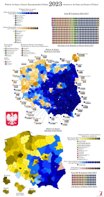
The Senate's deal with the Senate Pact 2023 reminds me of how Mexico handles its constituency seats vs. its proportional seats; all alliances and cross-endorsements.
 
Being aware of Oleh Lyashko's Radical Party, Vitali Klitschko's UDAR and other parties with the initials of their leaders, nothing surprises me
I'm glad you mentioned these, because looking them up and finding a picture of the former kissing a cow outside the Verkhovna Rada and that the latter's party is literally named 'PUNCH' because he used to be a boxer has substantially improved my day. Hope this isn't too off-topic, just wanted to share.
 
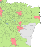
Back to Mandatory Palestine, and the Jerusalem district, which was originally made up of four subdistricts, centred in Jerusalem, Bethlehem, Jericho and Ramallah. Hebron was moved into the district in 1931, and in 1942, the Bethlehem and Jericho subdistricts were abolished and merged into the Jerusalem one. This made Jerusalem one of the biggest subdistricts, with around a quarter of a million inhabitants, whereas Ramallah was one of the smallest with just under fifty thousand. Ramallah subdistrict was overwhelmingly Arab, but only around 80% Muslim, the rest being Arab Christians, who were also a large minority in Jerusalem subdistrict, especially around Bethlehem which was majority Christian at the time. However, Jerusalem itself was becoming a hotbed of religious strife due to the growing Jewish presence - at the time of the last Ottoman census in 1914, around 15% of the city's population was Jewish, and as with Hebron, most of those were Mizrahi Jews who had no connection to, and not much interest in, the Zionist movement. By 1931, however, Jews made up a narrow majority when counting both the "old" Jewish community and the new arrivals, and both they and the Muslim community were keen to establish definitive control over the holy city. This led to a series of communal riots in the 1920s and 30s, of which the 1929 one was the worst and resulted in the evacuation of several Jewish suburbs.

As with Hebron, Ramallah had no Jewish settlements outside the towns, and Jerusalem had only a few. After the 1936-39 Arab revolt, the British administration had become convinced that Arab interests needed to be pacified, but also that ending all Jewish immigration to the Mandate (as had been the Arab revolt's goal) would be infeasible due to the increasingly inhospitable conditions facing Jews in Europe. The compromise was the 1939 White Paper, which, in addition to placing strict limits on Jewish immigration, put in place strict regulations on land transfer and divided the Mandate into three zones to implement this. The Free Zone, where no new restrictions were imposed, was limited to the Plains of Sharon as well as the area around Haifa and the city of Jerusalem proper. In the transitional Zone B, which covered the areas south of Rehovot, the coast along Mount Carmel and about half of Galilee, land currently in Arab hands could not be sold to a non-Arab without the High Commissioner's permission, and in Zone A, which covered the entire rest of the Mandate, no non-Arab could buy any land without the High Commissioner's permission regardless of who owned it currently. This compromise pleased exactly no-one: the Jews viewed the land laws as designed to prevent the creation of new kibbutzim and moshavim, without whose agricultural produce a future Jewish homeland could never become self-sufficient, while Arabs viewed the division of the Mandate into zones as a precursor to a full partition and the creation of a Jewish state that, no matter what the British may say, would inevitably seek to take over the rest of Palestine.

In the event, the immigration restrictions proved completely unenforceable, especially as the Second World War broke out and the idea of preventing Jews from escaping persecution seemed more and more inhumane. And of course, as has already been mentioned, the land laws were made irrelevant by the seizure and ethnic cleansing of dozens if not hundreds of Arab villages during the 1948 war, which set a pattern that would last until the present day.

1698440956451.png
 
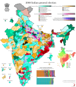
India 2009 (prov)
Touched up an unfinished draft I'd had lying around for quite some time. I can't find the remaining results in UP and Jharkhand, mainly because I haven't gotten the ECI website to work properly in ages (maybe it still works for people in India?), so I decided to give up and just post what I have.

In 2009, the INC-led government under Prime Minister Manmohan Singh won a second term, seeing a huge increase in seats over the very narrow 2004 election that had originally brought it to power. The UPA, the alliance formed to support the INC in its bid to retake power in 2004, won almost half of the seats - 262 out of 543 - but with the support of the "Fourth Front" parties and the BSP, they were able to form a stable majority government. The global financial crisis coupled with a number of corruption scandals eventually made this government deeply unpopular in the country, setting the stage for the landslide victory of Narendra Modi and the BJP in 2014.

The 2009 election was also the first one held on the set of boundaries currently used, which are based on population figures from the 2000 census. The government of Indira Gandhi, which oversaw the 1977 boundary review, was very keen (very very keen) on family planning, and in order to avoid punishing states for reducing their population growth, it was decided that the boundaries put in place then would remain in effect until after the 2001 census. The 2002 Delimitation Commission recommended no change in the apportionment of seats between states, instead simply redrawing boundaries within each state to bring them to rough parity. Even so, 499 out of 543 constituencies were redrawn for this election. The next Delimitation Commission is supposed to be appointed sometime after 2026, and will base its work on the results of the first census conducted after that point (presumably the 2031 census), so these boundaries will have a chance to become quite out of date themselves.

val-in-2009.png
 
Back
Top