• Hi Guest!

    The costs of running this forum are covered by Sea Lion Press. If you'd like to help support the company and the forum, visit patreon.com/sealionpress

Max's election maps and assorted others

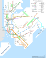
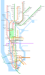
That's all of Manhattan and the Bronx. At least in terms of lines and service numbers, I'm still not 100% sure about stopping patterns. Starting to think the only way to depict them legibly (aside from just doing what the MTA map does and outright stating which services stop at each individual station) is to somehow distinguish lines that have express tracks from ones that don't.

1696107186948.png
 
Political representation in the Icelandic Althing? Or maybe the Sami Parliament?

That initial section feels very 'small left wing party presence in an otherwise 'non-partisan' chamber.
 
Ah damn, I thought of Åland about 5 minutes after posting that but decided not to edit in in.
 
I'm surprised there isn't really an equivalent to the SFP/RKP in that chamber considering Åland's demographics. Then again, since almost everyone there speaks Swedish I suppose on this level of government it's a non-issue.
 
I'm surprised there isn't really an equivalent to the SFP/RKP in that chamber considering Åland's demographics. Then again, since almost everyone there speaks Swedish I suppose on this level of government it's a non-issue.
The SFP dissolved its local organisation in Åland in 1920 because, unlike almost the entire local population, they opposed self-rule for the islands. The local electoral association continued to form electoral alliances with them until Åland became its own constituency in 1948, but since then there's been no participation from the party on any level. However, Åland's MP continues to sit with the SFP group in Parliament by convention, and the government of Åland has a representative on the staff of the SFP's sole MEP who's supposed to look after Mariehamn's interests in Brussels.
 
New York subway 2023
It's done, I think.

Surprisingly, the biggest question turned out to be how to depict those outer branches only served by express trains - I decided to label all stations along them as express stations, as I think that's what makes most sense to the casual observer, but it technically misrepresents them on a technical level, since "express station" usually implies a station with through tracks, which are obviously absent from these two-track lines.

ny-subway-2023.png
 
Cape Legislative Council 1898
Back to South Africa, and before we get into the South African War and its effects on the Cape's electoral politics, it is worth reminding ourselves that the House of Assembly was only half of a bicameral legislature. The upper house, the Legislative Council, had been set up at the same time, and was intended to provide the same kind of sober second thought that the House of Lords (theoretically at least) provided in Westminster. The Cape, of course, did not have a hereditary aristocracy, so instead the colonial administrators turned to the next-best thing: the landed rural elite, which very much did exist in the Cape and was a huge economic factor in the colony's internal life. To make sure that men of property and influence formed the backbone of the Council, the property qualification to stand for election to the upper house was set at a very hefty £2000, although AFAICT the qualification to vote was the same £25 (raised to £75 under Rhodes' electoral reforms) as for the lower house - in any case, Alan John Charrington Smith treats the voting figures for the two types of election as directly comparable, so I assume the franchises weren't too dissimilar.

The Council was elected separately from the lower house, although its electoral cycle was also five years, and unlike many upper houses in British colonies (looking at you, Australia - of course, the Victorian parliament was set up around the same time as that of the Cape, and resembled it in many ways), all seats were up for election at once. Initially, the Council had been elected from two large electoral divisions - the Western Province and the Eastern Province - which each covered about half of the colony, but over time this came to be regarded as a liability since the two provinces had strong regional identities and sometimes clashing interests, so in 1874 they were subdivided into seven new provinces. The old Western Province was divided into the Western, North-Western and South-Western Provinces, while the Eastern Province similarly became the Eastern, North-Eastern and South-Eastern Provinces. The Karoo and Orange River areas, which straddled the two old provinces, were made into a new Midland Province, and it was hoped that this would provide balance by supporting neither of the old provincial interests. Of course, by this point the diamond rush in Kimberley was well underway, and the influx of new English-speaking settlers would soon realign the Cape's politics from the old east-west divide to the Anglo-Afrikaner divide.

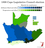
The other oddity of Legislative Council elections, and the probable reason they decided against staggered elections, was the use of cumulative voting. Under this system, while each voter got as many votes as there were candidates just as in lower-house elections, they could choose to give more than one of those votes to a single candidate. If voters chose to "plump" for a candidate, i.e. give them all three of their votes, that candidate would need only a third as many votes to get elected as would normally be the case, and this made it easier for minority interests to win representation. AJCS calls this "a crude form of proportional representation", and we can see the effects on the map below, as only one province (the Port Elizabeth-based South-Eastern Province) gave all its seats to the majority party.

By 1898, the Cape had expanded its territory significantly, with both the two Griqualands and British Bechuanaland being added to the colony. Griqualand East was merged into the Eastern Province, but the other two territories were made provinces in their own right, electing only one member each. This was in spite of the fact that Griqualand West, home to Kimberley and its diamond industry, had nearly as many voters as the smaller three-member provinces. Of course, these new provinces elected their members by FPTP, and in any case they were both dominated by Rhodes and the Progressive Party at this point.

The 1898 Legislative Council election was actually held several months before the lower-house election, in March of 1898, so these two maps are out of chronological order. Unlike the lower-house election, it returned a relatively healthy Progressive majority - 14 out of 23 seats - and while the upper house could not vote confidence in the government, this obviously did not make W. P. Schreiner's life easier when he took power later that year.
val-za-cape-legco-1898.png

(A quick note - the provincial boundaries may not be 100% accurate, as I'm basing them off of the fiscal divisions as of circa 1910 and quite a few of them looked different at this point)
 
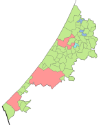
A little interlude spurred by recent events - here's what the Gaza subdistrict looked like in 1946.

Red - towns (from north to south, they are al-Majdal (today's Ashkelon), Gaza City and Khan Yunis)
Turquoise - kibbutzim (there's only one in this district, that being Negba)
Sky blue - moshavim (including Gan Yavne, the northernmost one, which I don't actually know if it was founded as a moshav or if it was a town from the beginning)
Green - Arab villages

1697204334813.png


As you can see, this was an overwhelmingly Arab region at this point - the 1945 population figures quoted on Wikipedia place the area's Muslim population at 145,700 and its Jewish population at 3,540 spread across the four settlements. The UN partition plan had it given to the Arab state pretty much in its entirety, but the IDF took over al-Majdal during the 1948 war, sending its Arab population of around 10,000 into exile and rechristening it Ashkelon after the Biblical city located in the area. Today's Gaza Strip covers about the southern half to two thirds of the district, along with some areas inland of Khan Yunis that had no permanent settlements at this point (and probably still don't) and sorted under the Beersheba District.
 
Last edited:
Seeing as there was just a police station and 5 houses at Eliat that might well be because there just weren't any.

I think so, though I might leave off the Negev as the map I'm working off of doesn't have any municipal borders there.

The Mandate's Constitution - the Palestine Order in Council of 1922, makes very direct reference to the governance of "tribal areas", which must have been basically the Negev and the Berbers living in it.

45. The High Commissioner may by order establish such separate Courts for the district of Beersheba and for such other tribal areas as he may think fit. Such courts may apply tribal custom, so far as it is not repugnant to natural justice or morality.
 
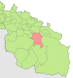
Hebron subdistrict was not very interesting, it was almost a hundred percent Arab and Hebron itself was the only town. There had been a small Jewish community in the area, mostly in Hebron town and mostly Mizrahi Jews who had lived there since long before the Zionist movement started, but they were all evacuated following a massacre in 1929 in which 67 of them were killed by Muslim mobs.

1697217478385.png
 
Back
Top