• Hi Guest!

    The costs of running this forum are covered by Sea Lion Press. If you'd like to help support the company and the forum, visit patreon.com/sealionpress

Max's election maps and assorted others

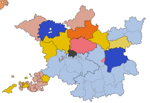
As if the schizophrenic nature of this thread over the past week or two wasn't proof enough that I'm spiralling mentally, I've actually started attempting to map the Frankfurt National Assembly elections.
1688575776436.png


Red is the Donnersberg faction, which was the most radical and wanted a democratic republic modelled on the United States. They originated as a split from the Deutscher Hof faction, in pale red, who were also committed to universal suffrage and the creation of a new German state with none of the trappings of the old order, but were generally less keen on revolutionary violence as a way to get there. The Westendhall faction, in orange, was a rightward split from the Deutscher Hof, and were nicknamed "the left in white tie" by their more radical colleagues - they nominally also supported a republic, but voted with the assembly's monarchists a number of times and were generally somewhat agnostic on the issue as long as some sort of liberal democratic order was established. This brought them pretty close to the Casino faction, in yellow, who were moderate liberal constitutionalists, most of whom supported a property-based franchise and a constitutional monarchy. The Casino were the biggest faction overall in the Assembly, although around a third of the membership belonged to no faction - the only such member seen here was the member for Nassau 1, which is depicted in independent brown as a result.
 
I had a look at verfassungen.de, and it's very annoying how they've faithfully transcribed every aspect of the electoral laws except (at least for the major states) the constituency boundaries.
 
1689000508916.png

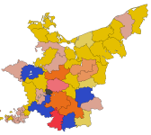
I found out Google Books has a bunch of Amtsblätter from 1848, at least some of which contain the full constituency descriptions. I can see now why verfassungen.de chose to exclude them, because a lot of them are very, very long. They seem to have actually cared about forming somewhat equal constituencies, rather than simply shoving districts together and calling it a day. At the same time it's very easy to tell how fast they were having to work in the atmosphere of 1848, because the division of Berlin into individual seats (there were six of them, numbered 6-11 in the overall Brandenburg numbering scheme) was left off this list owing to the fact that the city's internal subdivisions were currently in flux and it would be impossible to draw up constituencies before its polling divisions had been fixed. So that may have to come at a future time, although it is worth noting that a lot of electoral maps from the period just ignored divisions within the cities.

Also visible on this are the three remaining Anhalt principalities, each of which got to send one representative. Helpfully for future cartographers, the princely houses would go extinct one at a time until the Dessau line was the only one left standing, uniting Anhalt into a single duchy in 1863.

Oh yeah, and of the colours we haven't seen previously, blue is the conservative Café Milani faction, which was open to some changes from the old order (anyone so implacably reactionary wouldn't have stood for election in 1848) but still called for the new German government to essentially be a slightly revamped version of the old Confederation - the states were to remain monarchies, their constitutions and armed forces left intact, and the federal government be answerable to the monarchs rather than to whatever new Reichstag the liberals might dream up. Pale yellow, meanwhile, is the Landsberg faction, which is something of a confusing name given that the one constituency they're shown holding here is Landsberg/Warthe, but as with all the other factions it was in fact named for the restaurant where its members gathered. They were a split from the Casino faction, and politically very similar to them.
 
1689025350208.png

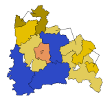
Bavaria, meanwhile, went the other way - constituencies made up of whole Landgerichte (court districts, which were also administrative districts at this time) which were decently equal in population without necessarily being contiguous. Unfortunately I've only been able to track down Upper Bavaria's Amtsblatt, but it should still give an indication of what things looked like. Needless to say, it's very interesting to see how Bavaria shakes down with no Centre Party present, and that's going to be true of the Rhineland too.

The dark yellow is the Pariser Hof faction, a conservative split from the Casino that approached the Café Milani faction in policy while retaining a basically national-liberal worldview.
 
Ooh, very useful for a thing my friend and I are planning in the rather quite far future. What are the light blue seats?
 
View attachment 70914

I found out Google Books has a bunch of Amtsblätter from 1848, at least some of which contain the full constituency descriptions. I can see now why verfassungen.de chose to exclude them, because a lot of them are very, very long. They seem to have actually cared about forming somewhat equal constituencies, rather than simply shoving districts together and calling it a day. At the same time it's very easy to tell how fast they were having to work in the atmosphere of 1848, because the division of Berlin into individual seats (there were six of them, numbered 6-11 in the overall Brandenburg numbering scheme) was left off this list owing to the fact that the city's internal subdivisions were currently in flux and it would be impossible to draw up constituencies before its polling divisions had been fixed. So that may have to come at a future time, although it is worth noting that a lot of electoral maps from the period just ignored divisions within the cities.

Also visible on this are the three remaining Anhalt principalities, each of which got to send one representative. Helpfully for future cartographers, the princely houses would go extinct one at a time until the Dessau line was the only one left standing, uniting Anhalt into a single duchy in 1863.

Oh yeah, and of the colours we haven't seen previously, blue is the conservative Café Milani faction, which was open to some changes from the old order (anyone so implacably reactionary wouldn't have stood for election in 1848) but still called for the new German government to essentially be a slightly revamped version of the old Confederation - the states were to remain monarchies, their constitutions and armed forces left intact, and the federal government be answerable to the monarchs rather than to whatever new Reichstag the liberals might dream up. Pale yellow, meanwhile, is the Landsberg faction, which is something of a confusing name given that the one constituency they're shown holding here is Landsberg/Warthe, but as with all the other factions it was in fact named for the restaurant where its members gathered. They were a split from the Casino faction, and politically very similar to them.

For a solid second my thought was "Hmm, those are some weird Austro-Hungarian borders"
 
1689111480916.png

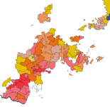
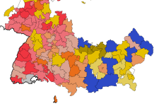
The Hessian states, as it turns out, do have their constituency descriptions on verfassungen.de, and there's a lot of really good historical maps of that region online, so while a few administrative divisions didn't line up I was still able to construct what should be a reasonably good approximation of the boundaries. So too with the smaller Thuringian states, although the four Reuss principalities that existed when the elections were called (three out of four were merged later in 1848) each had one seat and I can't find a good map of them.

Hessen-Darmstadt 3 and 4 don't have members listed on Wikipedia, so unfortunately I have no clue who represented them (if anyone) and what faction they may or may not have belonged to.
 
Was it actually one for each line? I'm pretty sure Lobenstein and Ebersdorf had merged by that point.

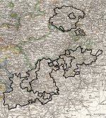
EDIT: Oh Calloo-Callay! A map of the Principality of Reuss in 1825 showing each of the 4 branches that had existed till the previous year!

EDIT 2: This one looks to be 1840 and might clear up the situation -Gera appears to have been treated as a separate 'duchy' of the younger line even though it technically wasn't actually and was with Schleiz.
 
Last edited:
View attachment 70957

The Hessian states, as it turns out, do have their constituency descriptions on verfassungen.de, and there's a lot of really good historical maps of that region online, so while a few administrative divisions didn't line up I was still able to construct what should be a reasonably good approximation of the boundaries. So too with the smaller Thuringian states, although the four Reuss principalities that existed when the elections were called (three out of four were merged later in 1848) each had one seat and I can't find a good map of them.

Hessen-Darmstadt 3 and 4 don't have members listed on Wikipedia, so unfortunately I have no clue who represented them (if anyone) and what faction they may or may not have belonged to.
1689116226181.png
 
Was it actually one for each line? I'm pretty sure Lobenstein and Ebersdorf had merged by that point.

EDIT: Oh Calloo-Callay! A map of the Principality of Reuss in 1825 showing each of the 4 branches that had existed till the previous year!

EDIT 2: This one looks to be 1840 and might clear up the situation -Gera appears to have been treated as a separate 'duchy' of the younger line even though it technically wasn't actually and was with Schleiz.

@Ares96 - I think this is pretty much the division. It looks remarkably equitable at first glance actually. Apart from being 4 members for literally the House of Reuss of course.

You'll obviously need to cross-reference with the standard Reuss map for some of the exclaves.

Reuss 1840.jpg
 
Apart from being 4 members for literally the House of Reuss of course.
Looks about right - apparently you're also right in that there were only three lines at this point, but the two younger lines ruled Gera as a condominium, so it was treated as a separate state for electoral purposes.

Worth noting though that only one Reuss Younger Line constituency, based in Hirschberg, is named in the Wikipedia list of members - it had three separate representatives, but none of them served concurrently. Also, none were called Heinrich, which is just weak.

On a separate note, I discovered that the Posen Amtsblätter were published in German and Polish side-by-side, and of course that also meant they were printed in different typefaces:

1689119575202.png
 
1689122573251.png

Pomerania had a frankly ridiculous way of listing its constituencies - it describes the parts of divided districts in terms of fractions, so you get things like "district A plus a neighbouring part of district B making up 7/12 of the total". With this in mind, I decided to just not bother figuring out the details and divide things up arbitrarily instead. I did the same for the parts of Brandenburg east of the Oder-Neisse line, so that's now done. Apart from Berlin, of course.
 
Worth noting though that only one Reuss Younger Line constituency, based in Hirschberg, is named in the Wikipedia list of members - it had three separate representatives, but none of them served concurrently. Also, none were called Heinrich, which is just weak.

There's got be mileage in 'the Elected Heinrich of Reuss' as an alternate title.
 
Hessen-Darmstadt 3 and 4 don't have members listed on Wikipedia, so unfortunately I have no clue who represented them (if anyone) and what faction they may or may not have belonged to.
Have you tried searching for Großherzogtum Hessen instead of Hesse-Darmstadt?
 
1689177611016.png

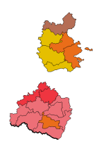
Baden and Württemberg turned out to be quite easily done, mainly because the administrative boundaries didn't change all that much between 1848 and 1914. As you can tell, Baden in particular was a radical stronghold, aided by the liberal disposition of its rulers and the presence of a state constitution that was very close to what liberals in the rest of Germany were fighting for. The Palatinate had kind of a similar thing going on, because it retained the French legal system from before 1815 and was sort of neglected by Munich, giving it a reputation as a sanctuary for liberal and radical intellectuals from the rest of Germany.
 
Little Lichtenstein sending its own delegate 😍
This clearly ruffled some feathers, because the 1849 electoral law for the proposed Reichstag - pointedly unlike the version of it in use after 1871 - included nine specifically named cases where small states could and should be merged with neighbouring ones for electoral purposes. These were:

- Liechtenstein with Austria (Vorarlberg, presumably, which makes a lot of sense on a cultural as well as geographic level)
- Hessen-Homburg with Hessen-Darmstadt in its main territory and with the Palatinate for the Meisenheim area
- Schaumburg-Lippe with the Hessen-Kassel exclave of Schaumburg
- the two Hohenzollerns with one another
- the two Reusses with one another
- Anhalt-Köthen with Anhalt-Bernburg
- Lauenburg with Schleswig-Holstein, or possibly just Holstein depending on how much territory would be included in Germany
- Oldenburg's Birkenfeld exclave with the Prussian Rhine Province
- Pyrmont with Prussia (presumably Westphalia, since Hannover was not part of Prussia at this point)

Curiously no mention was made of Oldenburg's exclave(s) north of Lübeck, which I can't imagine being big enough to elect a member in its/their own right at this point.
 
Back
Top