• Hi Guest!

    The costs of running this forum are covered by Sea Lion Press. If you'd like to help support the company and the forum, visit patreon.com/sealionpress

Max's election maps and assorted others

I mean it's the more natural politics for the area considering it was a big centre of industry and mining.

I can very easily see a flip of what happened historically in a surviving Austria-Hungary (or Austria-Bohemia if Galicia and Hungary are gone) where the German speaking areas have a clearly defined 'normal' politics of socialists vs. Agrarians with some minor parties on the edges while the Czech areas just end up with some big catch-all Nationalist party dominating equally well in areas of heavy industry and extremely rural farming areas.
TBF, looking into it, n the interwar Sudeten German politics was mostly similar to that of their Czech neighbors (if a little less secular) until the Great Depression discredited the mainstream Germanophone parties.
 
TBF, looking into it, n the interwar Sudeten German politics was mostly similar to that of their Czech neighbors (if a little less secular) until the Great Depression discredited the mainstream Germanophone parties.
The Nazis had a very deliberate strategy of propping up aligned local parties among the German-speakers in surrounding countries, and the SdP were very much part of that.
 
The Nazis had a very deliberate strategy of propping up aligned local parties among the German-speakers in surrounding countries, and the SdP were very much part of that.

True, but in fairness, the Sudetenland is where national socialism first arose both as an ideology and then as a political party, the German Workers' Party, preceded WWI. There was a non-insignificant voting bloc of both German nationalists (of a bourgeois nature, with roots in liberal nationalism) and German national socialists (of a more working class, petit bourgeois nature) present in the Czechoslovak institutions from the get-go. So they had plenty to work with.
 
True, but in fairness, the Sudetenland is where national socialism first arose both as an ideology and then as a political party, the German Workers' Party, preceded WWI. There was a non-insignificant voting bloc of both German nationalists (of a bourgeois nature, with roots in liberal nationalism) and German national socialists (of a more working class, petit bourgeois nature) present in the Czechoslovak institutions from the get-go. So they had plenty to work with.
That's certainly true - you'll notice how the Germans in Bohemia and Moravia (at least the ones who didn't vote for the SDAP) tended to be much more supportive of German nationalist parties than the ones in present-day Austria.
 
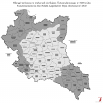
Poland 1919
Now for something tangentially related to the Austrian elections (pinging in @Heat here feels appropriate). I recently decided to redo my old interwar Polish election maps on a better base, and the ones I've found results for will be coming, but first off, one I haven't found the actual results for.

In November 1918, with Germany defeated, Austria-Hungary wiping itself off the map and Russia deep in the throes of civil war, a group of aristocrats and military officers in Warsaw proclaimed the rebirth of the Polish Commonwealth. This new Polish state wasn't quite built from scratch in that moment, as the Central Powers had allowed the Russian part of Poland to form its own government and raise Polish troops to fight alongside them, and indeed the Regency Council formed the previous year now made up the core of the new Polish state. Shortly after declaring Polish independence, however, the Council voted to cede all authority to Józef Piłsudski, a veteran independence activist and former socialist who was instrumental in forming the Polish Legion under Austrian auspices during the early stage of the war, only to then get jailed by the Germans when he refused to allow his soldiers to swear an oath to the Kaiser. This somewhat chequered political background made him an appealing figure to both the right and left wings of the Polish national movement, and his military past meant he was better suited to defend the new state than any of the noblemen who ran the Regency Council.

Piłsudski's rule was largely focused on military matters, as you'd expect, but one of his other early priorities was to ensure that Poland got a democratic constitution. To this end, just a few days after taking power, he signed a decree announcing legislative elections to be held in January 1919, and establishing 70 electoral constituencies from which the delegates of the new Sejm Ustawodawczy (Legislative Sejm) would be elected. If all seventy constituencies sent representatives, the Sejm would consist of 513 members, with 241 coming from the old Russian partition, 160 from Galicia and Cieszyn Silesia, and 112 from the eastern Prussian provinces. Of course, that's quite a big if.

In actuality, the list of 70 constituencies did not reflect the territories actually controlled by the new Polish government, but rather its territorial ambitions. Although unstable, the German government still had a decent hold on its eastern territories at this point, and in eastern Galicia, Polish claims were being contested by the newly-proclaimed West Ukrainian People's Republic. On the appointed day, 26 January 1919, only 43 constituencies actually held elections, choosing 291 delegates between them. Piłsudski also signed a decree allowing 28 former Imperial Council representatives from eastern Galicia and 16 Polish-speaking Reichstag members to sit in the new Sejm, meaning that the body that met in Warsaw on 10 February consisted of 335 members. A number of elections would later be annulled and redone, while border regions not under Polish control in January 1919 held proper elections later on. By the end of its term, the Legislative Sejm consisted of 442 delegates, of which 373 had been elected directly while another 33 were co-opted from older parliamentary bodies and 26 were indirectly elected.

Given this, I'm sure you can imagine it's hard to say anything definitive about exact party balance, but one thing we can say is that it was broadly speaking a right-wing body. The Communist Party and several other left-wing groups boycotted the elections, seeing them as a bourgeois sham designed to draw the proletariat's attention away from the fledgling world revolution starting in Russia right at that moment, and the PPS (the more Polish nationalist branch of the left) wildly underperformed expectations winning only about 10% of the vote. Significantly better off was the left-leaning peasants' movement, led by the PSL - "Liberation" (Wyzwolenie) in the Russian partition and the PSL - "Left" (Lewica) in Galicia, and these groups alongside the PPS would form the core of the left opposition throughout the Second Republic.

val-pl-1919.png
 
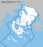
Karlskrona 1944 (wards and historical background)
This has been an extremely long time coming, but I spent my shift yesterday at (what used to be) the Karlskrona city archives, and since there wasn't a ton to do on a Friday afternoon, I got around to looking at the old council records to try to figure out some of the older ward divisions. My conclusions from looking at them were two: the books of council proceedings for Karlskrona look like absolute dogshit compared to those of the other cities I've looked at, but they are also pretty exhaustive and don't actually seem to be poorly bound, so that's something. Also, I remembered I had a pretty good basemap from ages ago when @Makemakean and I tried to do a local history TL in a month, and while I had to invert the land and sea layers which didn't make the end result too pretty, it did save me a lot of tracing.

Karlskrona was founded in 1680 to serve as the main base of the Swedish Navy - some popular histories claim Charles XI intended to eventually move the capital there, or at least make it a sort of winter capital, but I don't know how much there is to back that up. Whatever the truth of that, the island of Trossö went from housing one (1) farm to being the third city of the Swedish Empire by 1700. Its growth stalled a bit during the Age of Liberty, but it had a critical mass of around ten thousand inhabitants, and when Gustav III started his naval expansion in the 1780s, Karlskrona entered a sort of golden age. Which unfortunately didn't last too long - his eventual war against Russia wasn't a total writeoff, but the fact that it wasn't was largely an accidental stroke of luck on Sweden's part, and by the time it ended, a captured Russian ship had already brought the deadly bacterium Borrelia recurrentis to Karlskrona, resulting in a devastating epidemic which combined with an equally devastating fire in 1790 to bring a definite end to the city's flourishing. The early 19th century was another time of stagnation, and in the 1830s Karlskrona lost its place as Sweden's third city to rapidly-industrialising Norrköping (which would in turn lose it to the even more rapidly industrialising Malmö a couple of decades later). Things only turned around when the railway arrived in 1874, which allowed a number of light manufacturing industries to spring up - the most famous being the hat, kerosene lamp and porcelain factories, each of which was nationally renowned in its field - and started the only major period of population growth in Karlskrona's history aside from its founding years. From around 16,000 inhabitants in 1870, the city passed the 30,000 mark sometime during the Second World War and essentially stayed put until well into my lifetime.

By far the largest employer throughout all this was the Navy, both the actual naval base and the attached shipyard. The shipbuilders, their distinctive dialect and their alleged eccentricities formed a key element of the city's culture, and the admiral who commanded the base was generally regarded as the most important person in the city, ahead of both the magistrates, the guilds and the county governor. For most of the city's pre-1862 history, its politics were dominated by a sort of town-and-gown conflict between the naval hierarchy and the guilds, but when the guild system was abolished and a directly elected city council was introduced, the short-term effect of this was to simply allow the naval officer class to seize control of the civilian administration as well. As in most of Europe, these two sides eventually united to combat the rise of the trade union movement - whose main exponent, obviously, was the Metalworkers' Union section that organised the shipyard - but the fact that the shipyard was owned by the Crown and depended on an expansive naval policy for work meant that the usual class dynamics worked a bit differently. The union tended to be a lot less radical than shipbuilders' unions elsewhere, and a lot of the more comfortable workers voted for more "patriotic" right-wing options. As a result, Karlskrona wasn't as left-wing a place as you might expect given how industrialised it was - the Social Democrats won a majority for the first time in 1938, but lost it again in 1946, and a Liberal-Conservative majority ruled until the 60s.

The city was contained on Trossö and nearby islets (most prominently Björkholmen, just to the west, which is close to the shipyard, was the spiritual home of the pillemausare, and is where I'm currently sat writing this) for most of its history, partly because the original city plan was overly ambitious for the size the city eventually turned out to be, but mainly because of the position of the island a few kilometres off the mainland with only a single bridge connecting it. Until the railway arrived, most people and most commerce entered Karlskrona by boat, but the arrival of the railway had an interesting side effect - the two different railways (one standard-gauge, one narrow-gauge) built their stations at the old entrance to the city, and a strip of land was filled in across the bay separating Trossö from the larger island of Vämö to its north to accommodate the rail platforms and yards. The city began to grow north along the old highway and the western shore of Vämö, and the more prosperous burghers who were tired of the grime and congestion of Trossö (which had some of the worst slums in Sweden at this time - in the 30s, the government appointed a commission to investigate urban housing conditions and designate areas in urgent need of renovation, and Karlskrona was the only city with two entries on this "official" list of slums) began to build garden suburbs around the edges of the city. In 1910, a tram line was opened to connect some of these to the city centre, and this operated with no route changes or extensions until 1949.

By 1944, which is the earliest set of boundaries I've found, Karlskrona was divided into three constituencies which elected 14 councillors each for a total of 42 seats. Two of these constituencies were south of the bridge, in the old urban core of Trossö and surroundings, while Vämö and its neighbouring islands made up the third constituency. Each one was divided into exactly three wards, which makes things very neat, although these wards were apparently very unbalanced and would get hacked apart in the next rewarding. One thing worth noting, although it hardly mattered for electoral purposes, is that the city's territory also included the two small islands of Kungsholmen and Hästholmen, at the south and west approaches to the harbour respectively, which were annexed in 1904 to facilitate the construction of naval fortifications there.

kna-valdistrikt-1944.png
 
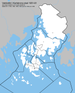
Karlskrona 1951-59 (wards)
The 1952 municipal reform was not too dramatic in Karlskrona's case - it expanded north a bit on the mainland, although the new boundary was drawn somewhat arbitrarily and specifically avoided the few population centres there, so I assume it was more about providing land for post-war housing expansion than consolidating the urban area. Only 456 people lived in this area, so there wasn't much change in electoral terms - one new ward was added covering the entire mainland territory of the city. More significant for the map of the city (although I haven't depicted them properly here) were the islands of Aspö and Tjurkö, on either side of the main approach to the city from the south, which had both been independent municipalities but had serious economic troubles that would only have gotten worse as municipal governments were expected to form the backbone of the new welfare state. Aspö had 752 inhabitants and Tjurkö 298, but both retained their own parishes and their own electoral wards for obvious geographic reasons. Even though AFAIK the ferries left from the western side of Trossö, the islands were nonetheless added to the first council constituency and their wards numbered 4 and 5, hence the gap in ward numbers on this map.

Aside from the new mainland ward and the two islands, the only changes to the ward map were to level out the populations. In the 1950 elections, ward 3 had some 2,000 registered voters while wards 6 and 9 (now renumbered 8 and 11) each numbered around 4,000. Splitting off the mainland solved the latter problem, but some of the other ward changes were extremely awkward. The new ward 7 included a slice of Björkholmen that was totally detached from the rest of the ward, and ward 1 similarly now cut across the old bridge to take in three blocks of Pantarholmen - an especially egregious change given that Pantarholmen was now split between two different constituencies.

kna-valdistrikt-1951.png

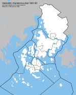
The 1951 boundary changes were controversial from the beginning, and when the time came to draw up a new electoral roll in 1961, it was decided that the boundaries should be drawn more reasonably - especially those of the constituencies, but also the wards as far as practical. The city's population had grown since 1951, and turnout had jumped from the low 60s before the war to the high 70s for most of the 1950s, so for those reasons it was seen as reasonable to increase the overall number of wards to 15. One new ward (10) covered all of Pantarholmen, splitting it off from wards 1 and 9, while Hästö was given its own ward (13) and the mainland ward was split in half to account for the growth of the new housing estate in Marieberg. To make the constituencies slightly more even, Långö (ward 9) was moved from the third to the second constituency, and the seats were redistributed so that each constituency actually elected a proportionate number of councillors rather than strictly fourteen each.

kna-valdistrikt-1959.png

These boundaries, although they made a great deal of sense, did not stick around long, because Karlskrona merged with the neighbouring municipality of Lyckeby after the 1966 local elections, which meant they had to redraw the wards yet again. And unfortunately, I wasn't able to find those boundaries the other day.
 
Poland 1922
A lot happened between 1919 and 1922 in Poland, indeed, probably too much to write here. Unquestionably the biggest thing was the Polish-Soviet War, in which Polish forces advancing east to reclaim former Polish lands and realise Józef Piłsudski's ambition of creating a Poland strong enough to defend itself from the neighbouring great powers rather inevitably came into conflict with Red Army forces advancing west to link up with the German Spartacists and kickstart the world revolution. The Soviets did pretty well for a long time, but were finally stopped at the gates of Warsaw in August 1920, in what became known in Polish historiography as the "Miracle on the Vistula". Soon enough, the Poles were marching east again, and in March 1921, the Polish and Soviet governments signed a peace treaty in Riga, which drew a very favourable eastern border for Poland. They didn't get the entire former Polish-Lithuanian Commonwealth as Piłsudski had wanted, sure, but all of Galicia and Volhynia and a good chunk of Belarus ended up in Polish hands. At about the same time, the border with Germany was finalised following plebiscites in Masuria and Upper Silesia. Those borders ended up less favourably for Poland, because the plebiscites had been held right when it seemed like the Polish state was on the verge of collapse, and so plenty of Polish-speaking locals voted to stick with the devil they knew.

Far from all of these territories were ethnically Polish. Minorities existed almost everywhere, sure, but most of the eastern lands (the Kresy, which just means "border regions" in Polish) were majority East Slavic, and the former German partition had sizeable German minorities throughout. And, of course, there were Jewish communities all over the country. Most of the Jews in Germany had made a strong effort to assimilate and speak Standard German after the ghettos were dissolved, but in Galicia and the Russian partition, where they were surrounded by Slavic peoples rather than Germans, this was understandably quite a lot harder - not to mention the repression they faced from Russian state authorities in particular. So there was a very strong Jewish identity in Poland at this time, and the Yiddish language was one of the largest minority languages in the country with over two million native speakers. Although opinion was divided among these groups on whether they ought to be part of Poland, most of them recognised the threat of Polish ethnonationalism winning control of the new state, and at the initiative of Yitzhak Grünbaum, a veteran Jewish community leader and journalist, a number of different minority groups united for the November 1922 parliamentary elections as the Bloc of National Minorities (Blok Mniejszości Narodowych, BMN). The BMN's leadership was made up of an equal number of Jews, Germans, Ukrainians and Belarusians, although Grünbaum acted as the unofficial leader of the movement, his skills as a journalist and community organiser carrying over very well into parliamentary work. The BMN didn't gather quite every minority group, however, with several Jewish and Ukrainian groups staying out of it - most of the latter boycotted the elections altogether, dismayed by the way Poland had subsumed the West Ukrainian People's Republic in 1919.

It may be worth stopping here to dwell on the nature of Polish nationalism, which had been divided into two broad camps even before the war. As mentioned, Piłsudski was an advocate of territorial expansion, believing that Poland would never be able to defend its independence if it didn't cement itself as a significant player in European politics in its own right. Supporters of this style of Polish nationalism, known as the "Jagiellon Concept" after the royal house that had built up the Polish-Lithuanian Commonwealth, believed in a place for ethnic diversity, carrying on the PLC's tradition of being somewhat welcoming to groups like the Jews and the Greek Orthodox Eastern Slavs, but also generally believed that the Poles had a historic role as the leading ethnicity of the state and that the other ethnic groups in the area would welcome them as liberators. On the other hand, there were the supporters of the "Piast Concept", named for the dynasty of dukes and kings who founded the Polish state in the 10th and 11th centuries. Led by the National Democracy (Narodowa Demokracja, ND or Endecja) movement, they were generally a lot less keen on expanding Poland's borders, and a lot more keen on making sure any Polish state was politically stable and homogenously Polish. In their view, the expansive and permissive nature of the PLC was precisely the thing that had made it vulnerable, and military adventures by the new Polish state were only bound to make enemies of the peoples around them. The important things would be to secure a close relationship with the West, especially with fellow Catholic powers like France, and to make sure that (Catholic) Poles would be the masters of their own destiny within Poland. It shouldn't surprise you that they pretty much all saw the Jews as the single biggest threat to this, and that's worth bearing in mind for the 1928 election especially.

In 1922, there wasn't really an organised political party advocating for Polish nationalism based on the Jagiellon Concept, which might come as a surprise given that its proponents had effectively governed Poland since 1919. However, that power was concentrated in the person of Józef Piłsudski, who relied on emergency laws to impose his will on the administration. The Legislative Sejm, on the other hand, was dominated by Piast Concept supporters, who drew up a constitution modelled on the French one with a very strong parliament and a ceremonial presidency. This annoyed Piłsudski so much that he refused to stand for the presidency and declared he would retire from politics as soon as a successor could be elected. Obviously, this emboldened his rivals, chief among them the Endecja's political wing the People's National Union (Związek Ludowo-Narodowy, ZLN), who formed an electoral alliance with the Polish Christian Democratic Party (Polskie Stronnictwo Chrześcijańskiej Demokracji, PSChD or Chadecja) led by Silesian activist and former Reichstag deputy Wojciech Korfanty, as well as a number of other right-wing Christian groups who formed the Christian-National Club (Klub Chrześcijańsko-Narodowy, KChN). This alliance was dubbed the Christian Association of National Unity (Chrześcijański Związek Jedności Narodowej - you'll sometimes see this rendered as "Christian Union of National Unity", but I'm choosing to avoid the tautology since it's not there in Polish). Local wits decided to abbreviate this name to Chjena, which is pronounced like "hyena", and despite their own protests, this abbreviation very quickly became ubiquitous.

The Chjena's mockers could laugh all they wanted, because the situation was very clearly favourable for the alliance. In western Poland, especially the ZLN's strongholds in Greater Poland and the Chadecja's one in Silesia, they were completely dominant, and although they were a lot weaker elsewhere in the country, they won a commanding lead in the popular vote with almost 30% of the Sejm vote and almost 40% of that for the Senate (which had a smaller electorate, I believe you had to be 30 to vote for it and 40 to stand for election). Of course, that's not a majority, and the rest of the scene was divided between the BMN, the two different PSL factions left standing, and the PPS, in addition to a gaggle of smaller parties. None of them got along very well, but they all hated the Endecja enough to block them from influence. When the new National Assembly met in joint session to choose a president, the Chjena's candidate, the Ambassador to Paris Count Maurycy Zamoyski, lost by a fairly big margin to Piłsudski's preferred candidate, the renowned engineer, PSL-"Wyzwolenie" member and former Minister of Public Works Gabriel Narutowicz. However, after just five days in office, Narutowicz was assassinated by a rogue art critic and Endecja supporter named Eligiusz Niewiadomski (these names, my God), and the election had to be rerun. Once again, the Chjena put up a candidate, this time the historian Kazimierz Morawski, who again lost, this time to the PSL-"Piast" politician Stanisław Wojciechowski, a friend of Piłsudski's who had been active in the PPS alongside him back in the 1890s. Although thought close to Piłsudski, Wojciechowski would in time become one of his key enemies, as discontent with the unstable parliamentary regime of which Wojciechowski was the figurehead grew out in the country.

Speaking of which, although the new Sejm was able to elect a president twice over, forming a government proved rather harder. The nonpartisan, but conservative, ministry led by Julian Nowak continued in office through most of December, being replaced by a caretaker ministry headed by General Władysław Sikorski (who played a key role in the Miracle on the Vistula and would play an even more key role in the Second World War). This lasted well into 1923 before a parliamentary government could finally take office, headed by Wincenty Witos of the PSL-"Piast" and comprised of them and the Chjena parties (to give some idea of how universal that name had become, the coalition was known as the Chjeno-Piast). This in turn lasted about six months, and then the carousel started back up again.
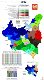
val-pl-1922.png

As a corollary, I made a turnout map, which I think is a pretty good illustration of what would become known as the "Poland A"/"Poland B" divide. Areas west of the Vistula, including Western Galicia to some extent, were generally highly industrialised, highly literate and highly politically conscious, which is reflected here in turnout levels of around 80%. The east, on the other hand, tended to be a lot less economically developed and also a lot less ethnically Polish - the figures for Eastern Galicia specifically are affected by the Ukrainian boycott, and those constituencies will look very different in the next election, but then again, so will the entire country. Because you see, not all was well in the state of Poland, and the military especially were deeply dismayed to watch the country they had fought to liberate descend into political backstabbing and corruption within months of its creation. Rumblings were heard through the barracks and the boardrooms, calling for a "cleansing" (sanacja) of the Polish body politic, and they would soon find backing from the highest possible quarters.
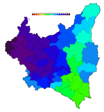
vald-pl-1922.png
 
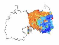
It's interesting (if not all that surprising) that even in 1922, you can see the old imperial borders of Prussia/Germany, Russia, and Austria-Hungary reflected in the results and the turnout map, something that's continued to the present day (albeit the partisan makeup has changed). I'm sure we're all familiar with this old map from ~2007 that circulates all the time:Da6bftPV4AAnwzQ.jpg
IIRC there hasn't been a ton of shift in the last 15 years, aside from metro Warsaw becoming even more supportive of PO and some of rural Pomerania becoming more PiS-friendly.
 
It's interesting (if not all that surprising) that even in 1922, you can see the old imperial borders of Prussia/Germany, Russia, and Austria-Hungary reflected in the results and the turnout map, something that's continued to the present day (albeit the partisan makeup has changed).
I mean, as you say, it’s a lot less surprising here given that Poland has existed for about 3-5 years at this point depending on whom you ask.
 
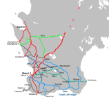
Here's a new project I started today - I don't know if I'm going to do the whole country or just the south, but we'll see. (Let's face it, I am going to do the whole country, even if I don't end up finishing it until two years from now)

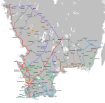
These are the railways in Malmöhus County (with a few lines in surrounding areas, and a few branch lines still missing) as of circa 1926, the time when the Swedish Railway Society published its 50th anniversary book with a full set of maps of the extant railway lines. These maps have been digitised and (very poorly by current standards) drawn over to illustrate the excellent if very Web 1.0 railfan site historiskt.nu, which is the reason I'm using that somewhat arbitrary date as a benchmark. Red is state-owned lines, shades of green and blue are major (by which I mean "owned more than one line") private railway companies, and grey is single-line private railway companies. Worth noting that "private" is a strictly legal term here, as quite a few of these were owned in part or in whole by the city councils of whichever cities they connected to the mainline network.

järnväg-1927.png
 
järnväg-1927.png

This should be everything in Scania, except of course for the segment over Hallandsås, which I still need to find a map of the pre-2015 alignment to draw over. Worth noting that MJ and YJ were both joint administrations rather than actual companies - their lines remained separate companies with separate boards and shareholders' meetings, although in at least the case of YJ, their operation was so thoroughly merged that they even shared rolling stock.

I also tried to indicate both the fact that the state main line was double-tracked up to Hässleholm and the fact that the Blekinge network was narrow-gauge - I will not be indicating different types of narrow gauge, except maybe in brackets next to the company names. At least to my knowledge, there were no private railways operating different gauges as part of the same company, so I should be able to get away with that.
 
järnväg-1927.png

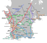
A bit of additional progress, including the first proper narrow-gauge networks. Let me know if this way of indicating gauge works or if something else would be better - as mentioned, I'm not too keen on the idea of using a different line width for each individual gauge size.

Växjö had a joint administration for most of the lines starting or ending there, including the CWJ as well as the line to Alvesta and a few different narrow-gauge lines in two different gauges (891mm north of the city, 1067mm south of it), and I'm thinking over whether I should just stop indicating joint administrations altogether rather than find a way to fit that into this scheme.
 
järnväg-1927.png

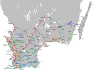
I lost a good chunk of my work from yesterday, so I didn't bother redoing Öland, but I still managed to add a good amount of track in Halland and south Västergötland. As you can see, there were quite a few large-ish private railways in this part of the country, but we've still yet to reach the two biggest ones.

Also, I changed the font on the railway names and gauges to (appropriately enough) Bahnschrift, but the station names are still Arial because it's too much of a hassle to go through everything and change it. I think there might be some value in having the fonts be different, assuming it's not too hard on the eye.

EDIT: And yeah, I noticed Strömsnäsbruk-Delary is the wrong line width, I'll fix that in the next update. I've probably got to redraw that one anyway.
 
Last edited:
View attachment 63556

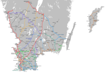
Now with both islands! Plus a bit more progress on the mainland, I guess.

Won't lie, I genuinely had no idea that they had railways on Gotland. I always just assumed that just like Iceland, they had just decided that the population was too small to justify one seeing you couldn't link it up with any network elsewhere.

Now that I'm looking into it, I'm learning that not just does Bornholm have railroads, at one point they had three separate railway companies, which really makes one raise an eyebrow over how that is even possible.
Gotland had four at this point - each one of the branch lines was a separate company. You eventually begin to understand why the Great Depression made basically everyone realise this wasn’t a tenable way to organise things.
 
Back
Top