• Hi Guest!

    The costs of running this forum are covered by Sea Lion Press. If you'd like to help support the company and the forum, visit patreon.com/sealionpress

  • Thank you to everyone who reached out with concern about the upcoming UK legislation which requires online communities to be compliant regarding illegal content. As a result of hard work and research by members of this community (chiefly iainbhx) and other members of communities UK-wide, the decision has been taken that the Sea Lion Press Forum will continue to operate. For more information, please see this thread.

Caprice's Maps and What-Not

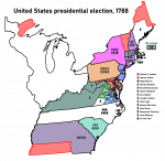
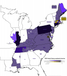
While it was effectively uncontested on the presidential question, the 1820 presidential election saw some Federalists chosen to the Electoral College, who chose a disorganized variety of vice-presidential candidates. Ohio and Kentucky are shown as unopposed as, while the positions of elector were contested, everyone agreed on the Monroe/Tompkins ticket, and results were spotty at best.
1820-pres.png
 
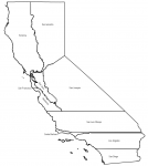
I found a book of information on the unreformed California state legislature, including district maps, for less than $10, so I guess California maps are happening after finals season.
 
1645590339646.png

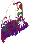
I'm doing a Thing of the 1914 Maine state elections for a GIS class final - so far I've gotten this map of the gubernatorial election by town where the red value is the Republican vote, the blue value is the Democratic vote, and the green value is the Progressive vote. I intend to improve it from here, of course, but I've gotten this far.

:dem:
Oakley C. Curtis - 62,076 (43.82%)
:rep:
William T. Haines - 58,885 (41.57%)
:prog:
Halbert P. Gardner - 18,226 (12.87%)
:soc:
Percy F. Moore - 1880 (1.33%)
:pro:
Frederick A. Shepherd - 597 (0.42%)
 
Back
Top