• Hi Guest!

    The costs of running this forum are covered by Sea Lion Press. If you'd like to help support the company and the forum, visit patreon.com/sealionpress

Caprice's Maps and What-Not

1612681838443.png

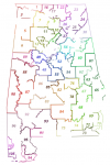
I decided to try to write a reference book for state legislative boundaries, since there is no centralized resource. Work is happening very slowly on the Alabama State House effective from 1975 to 1984. Red is sketch/preliminary lines, blue polygons are finalized districts.
 
You do the Lord's work and also bloody hell that's ambitious.
It sure is ambitious. Hopefully I manage to get my way through it, hahah.

Things happened, and now I'm digitizing 1950 precinct maps, because they're the closest I can get to 1970, and they'll be relevant for my TL's electoral shenaniganry anyhow so why not.

1612849240556.png

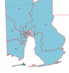
Relatedly, can someone who's familiar with QGIS tell me how to make multiple polygons part of one entry on the attributes table? Bits of Mobile and Baldwin county are islands.
 
No idea, but I've noticed a lot of online systems which utilise QGIS or similar group then together (thus resulting in maps where the coastline is quite blobby) so it might not be possible.
 
The other day, I finally found a map of the 1970s Alabama state house districts and realized that I had been looking at entirely the wrong plan. So now, after getting a legal description from the state archives, I can now work on the map. So far, I've blocked out most of the districts based on county census division borders; I have no enumeration district maps and the census tract maps I have only cover parts of the state.

1615925703682.png
 
1615962459614.png
A census tract map of Birmingham and environs, with state house districts overlaid. I will need to call the Census Bureau for block group and enumeration district boundaries.
 
It sure is ambitious. Hopefully I manage to get my way through it, hahah.

Things happened, and now I'm digitizing 1950 precinct maps, because they're the closest I can get to 1970, and they'll be relevant for my TL's electoral shenaniganry anyhow so why not.

View attachment 32471

Relatedly, can someone who's familiar with QGIS tell me how to make multiple polygons part of one entry on the attributes table? Bits of Mobile and Baldwin county are islands.
There should be a button on the menu that looks like two green blobs being stitched together. Select all of the polygons you want to merge and then click that button.
 
1615982714647.png
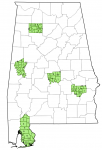
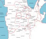
I've also thrown what I have into QGIS, and I have eight districts and 29 counties finalized. I will probably have to bother the Census Bureau for 1970 enumeration and census block maps.
 
I found some maps of cities for the 1970 census on Google Books, and while they're hi-res enough for me to glean enumeration districts, they're too low-res for blocks and they don't show block groups for Mobile, which uses them

1615993350506.png
And these tracts are split by block group

Progress is happening, though; I'm up to some twenty districts finalized.

EDIT: I used 1990 block groups, because they're meant to be backwards compatible.

1615996415920.png
 
Last edited:
I decided to give Alabama a break, and moved on to Vermont due to a suggestion from someone on the Our Fair Community Discord.

1616732374314.png

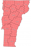
Here are the state representative districts as established for the 1965 "Supreme Court shut down the state legislature" snap election. District 1 was allotted fifteen representatives, District 2 nine, District 3 six, Districts 4 and 5 five, Districts 6-8 four, Districts 9-14 three, Districts 15-36 two, and Districts 37-72 one each. Districts 1 through 14 were split up further so that no one place would elect more than two representatives, but I have yet to figure out how. It seems to have been decided locally.

The non-incorporated areas were just left out entirely. Voters in those areas could apparently register wherever.
 
Last edited:
1616882048518.png

Ever since the 1974 election, Vermont's state senate districts have been named after counties, and based off them, but they have had slightly different borders for population equality reasons.
 
Last edited:
I've just realized that I have no idea how to quantify Vermont State Senate votes well enough to color them in. My first thought was to just use averages for each party, but party fusion is rampant, to the point that the official Vermont elections archive has a special color for joint Democratic and Republican nominees. Said fusion total is also rarely anywhere near close to the two party averages added. See this screenshot:

1616952640888.png
 
A draft for tablature of election results in SalC, featuring a draft of a state general election in which the biggest parliamentary group is a vague gaggle of regionalists.

CandidateSloganVotesPercentageSeats
Gordon PersonsI Am a Regular Human Being, And Not an Alien From Mars 137,15532.84%126
Phil HammI Will Dropkick Any Interior Designers Who Attempt to Adjust the Royal Office56,39713.50%50
J. Bruce HendersonI Will Move the Capital to Camden, as I Have Lived Around There My Whole Life38,8679.31%44
Elbert BoozerFor Anniston and For Alabama48,22111.55%36
Chauncey SparksBourbon - I Need Not Say More27,4046.56%20
Bull ConnorA Conservative Voice for the People of Birmingham20,6294.94%17
Robert BellWe Here in Huntsville are Up In Our Own Way20,1714.83%14
John S. CrowderI Think That Someday We Should Think About How We Voted to Have a Civil War Ninety Years Ago15,1773.63%9
Reuben NewtonJasper Is Not A Town to Be Joked About15,5023.71%8
Joe MoneyContrary to Popular Belief, I Have Never Even Been to a Bank10,5282.52%4
William M. BeckI Will Live in Fort Payne for the Rest of My Years, and So Will You If I Am Elected10,2182.45%3
Albert StappDon't Stop Stapp6,2001.48%2
Wiley GordonBlount County Regionalist6,0731.45%1
Hugh DuboseReally, I Just Want to Get Into the Assembly2,5940.62%1
James M. DementFor the Last Time, I Am Not Greek, You Are Thinking of Entirely the Wrong Athens2,0300.49%1
W. R. FarnellI Don't Think I Am Asking For Much When I Say I Want One Percent of the Vote In Just One County7480.11%0
 
In my other sort-of-timeline, Slightly More Canada, in which America is... slightly more Canada, some notes on Vermont.

The Vermont Provincial Assembly is unicameral, with 255 members, one for each town-equivalent. Instead of each town-equivalent electing its own MPP, however, they are apportioned proportionally among the counties, with no one member representing a division with less than two thousand or more than three thousand inhabitants. Elections are held in September.

1617514739786.png

I'm going to have to break this down.
 
1617565028607.png

Well, I've broken it down to the town level as best I can. I will outsource the further breaking down to a Discord server I'm in.
 
Sometimes I think about how Minnesota accidentally made its legislature non-partisan for a majority of the 20th century. Someone tried to kill a bill by amending it to make the legislature non-partisan and it just sort of... passed anyway?

Also the time Illinois forgot to redistrict its state house and thus an election was held at-large for the entire state
 
Last edited:
Back
Top