• Hi Guest!

    The costs of running this forum are covered by Sea Lion Press. If you'd like to help support the company and the forum, visit patreon.com/sealionpress

Max's election maps and assorted others

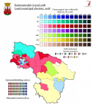
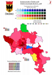
Örebro 2018
  • Örebro 2018. Bear in mind that the outgoing control here is a centrist coalition of S, C and KD - the latter two's voters don't seem to have cared - if anything, KD has gone up, they were in second place in a couple of districts in western Örebro city.

    I've got Jönköping nearly done, but I'm waiting on the official decision verifying the results before I put seat distributions in. Suffice it to say it looks quite German.

    val-2018-öbr.png
     
    Last edited:
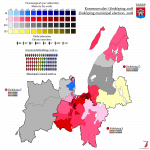
    Jönköping 2018
  • Jönköping 2018, once more, is a city of the... err, well, the shade I use is grey, but they've never used anything other than dark blue AFAIK, so.

    The outgoing mayor, weirdly enough, is of the Centre, which made Jönköping the biggest Centre-led municipality in the country. No idea how it'll end up this time, but the Alliance went up to 39 out of 81, so no change of power is likely.

    val-2018-jonk.png
     
    Last edited:
    Sverige 2018 (K)
  • Something I amazingly didn't do for 2014: an overview map of the municipal elections, with margins for each council. Bear in mind that while the map looks very red, there were a lot of places where the Social Democrats made it to first place but were still outnumbered by the Alliance combined. I'll probably complement this with a map of controlling coalitions once we know what those are going to be.

    Kommunvalen 2018

    val-k-2018.png
     
    Last edited:
    Scotland 1703 (constituencies)
  • Because my Scottish basemap is about to become illegal and also I'm avoiding coursework, have a map of the constituencies for the Scots Parliament as of the last pre-union election.

    val-scot-1703.png

    This is only part of the chamber, because unlike the English Parliament with its strict division into Lords and Commons, the Estates of the Scots Parliament sat as a single chamber and voted by head (mostly - originally the shire commissioners had to share one vote per shire). Beside the burgh and shire commissioners, there were also ex officio seats for all nobles above the rank of viscount, as well as those created Lords of Parliament by the monarch, and before the Reformation also for prelates. Even though all the monasteries in Scotland were secularised during the Reformation, their "abbots" (i.e. whoever owned the land) retained seats in Parliament, but the bishops' seats were formally abolished by the Covenanters in 1638. Starting with the Union of the Crowns, the monarch also sent a personal representative to Parliament, who received the title of Lord High Commissioner, and performed the parliamentary functions of a head of government.

    The union with England in 1707 reduced the number of MPs to 45, but without quite disenfranchising any of the constituencies as such; the burghs (except Edinburgh) were merged into groups of four or five, who chose a member each through an electoral college where each burgh had one vote, and the shires were reduced to one member each. The six smallest shires were grouped into pairs (Bute and Caithness; Clackmannan and Kinross; Cromarty and Nairn), which sent an MP to every other parliament and had no representation in every other one.

    EDIT: Also the border between Ross and Cromarty isn't on this because it's an absolute pisstake and also this is a post-1889 basemap.
     
    Last edited:
    Sverige 2018 (Weimar)
  • val-2018-weimar.png

    The Weimar map is back, folks. Those of you who remember the last one and/or know the Weimar electoral system by heart (hi @OwenM) can skip the writeup, but as a refresher for the rest of you:
    - The country is divided into constituencies and groups of constituencies. For the most part, the constituencies match the existing ones, but I've taken the liberty of splitting Östergötland in half and Stockholm County in three - for the 2014 map I also split Gothenburg in half and Stockholm in three, and in theory I'd still quite like to do that, but this felt good enough.
    - In each constituency, a raw 15,000 votes (60,000 in the original, but half the constituencies would have no seats if I set the bar that high here) equals one seat, exactly 15,000, no rounding up whatsoever (except in Gotland, because it felt like taking the piss to leave it unrepresented). With 15,000 votes per seat discounted, each remainder of 7,500 votes is transferred up to the group level.
    - For the groups, the transferred remainders are collated, and the same rules apply - if the remainders add up to 15,000, a seat is awarded on the group level, if not, then (as all of them are by definition above 7,500), the remainder is transferred up to national level. So are any remainders that qualify after seats have been awarded. The groups of three constituencies clearly work best for this, but I felt like drawing natural divisions was more important than equality, so these groups are a tiny bit dysfunctional in places.
    - At the national level, the remainders from the group level are collated and seats distributed. Remainders from that level don't matter.
    - The above means that the size of the legislature fluctuates depending on turnout, and whereas my 2014 calculation gave 352 seats, the number increased to 374 this year because of the turnout boost. There wasn't a whole universe of change beyond that, but the quotas can be unforgiving toward smaller parties, and the Greens in particular took an even worse hit, winning only 10 seats.
    - There's no threshold at play here, so any party that gets 15,000 votes can get a seat if it's concentrated enough. But unlike in 2014, where FI got in with five seats, no additional parties were able to meet that threshold although both FI and AfS received more than 15,000 votes overall.
     
    UK 1654 (constituencies)
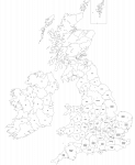
  • A quickie - the constituencies used for the First Protectorate Parliament in 1654. I believe they were the same for the Second Protectorate Parliament two years later, but I'm unsure.

    These parliaments have often been considered ahead of their time, drastically reducing the number of boroughs and apportioning county seats very roughly by population - in England. Scotland and Ireland were, shall we say, more questionable, as a result of being assigned only 30 MPs each. This in spite of the fact that Scotland had about a million inhabitants at the time, Ireland between two and three million (I only have figures for 1700, but suffice it to say I doubt Ireland grew that heavily during the 17th century) and England and Wales around five million.

    val-uk-1654.png
     
    Russia 1917 (provisional)
  • val-ru-1917.png

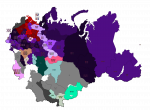
    Just three territorial constituencies left now - Yakutia, the Amur (which included the Maritime Province and Sakhalin, in spite of local leaders crying foul, and featured some insane list splits as a result of this), and Kamchatka. Of course, there were also constituencies covering the different military formations, which elected 81 deputies between them and were generally Bolshevik strongholds, with the exception of the Romanian and Caucasus fronts which elected majorities of SRs.

    There was also an extremely dank FPTP constituency for the workers on the Chinese Eastern Railway, which was based in Harbin and allowed elections to go through in spite of the local Tsarist administrators having tried to proclaim an "All-Russian Emergency Government" in March of 1917. The elections featured the aforementioned railway administrator standing for the Kadets, a Jewish businessman as the SR candidate, the chairman of the Harbin Soviet as the Bolshevik candidate and a local union agitator as the Menshevik candidate - the latter managing a narrow upset over the Bolshevik, the only constituency they won except for Transcaucasia.
     
    Sverige 1921 (FK)
  • Another oddity the Swedish government reforms of the 1910s threw up was the last full elections for the First Chamber, held in September 1921 alongside the general. The reform that had seen female suffrage introduced and the constituencies merged into bigger ones also included merging the 30 existing First Chamber constituencies into 19 new ones, and also extending the term to eight years. The system of indirect election by county councils continued, with one notable change - cities outside county councils, which were previously eligible to send their own delegates to the First Chamber, now had to choose electors whose number matched the apportionment they would have if they were part of their county council. Stockholm and Gothenburg were exceptions to this, and continued to be constituencies in their own right.

    The 19 constituencies were divided into eight groups, which were to replace their members in staggered elections as had been done by the six previously-existing constituency groups. But in order to inaugurate the new system, and because local election suffrage had also been equalised, all eight groups voted in 1921, and their members served out unequal terms. The members for Stockholm and Uppsala counties as well as Västerbotten and Norrbotten only sat for one year before their term was up, and the chamber continued to be gradually renewed each year until its abolition in 1970. Over time this came to benefit the Social Democrats greatly, as they held a consistent majority from around 1940 until the end, but this wasn't yet visible in 1921. The compact conservative majority that had characterised the old chamber, though - the one whose electorates were chosen by weighted suffrage that included corporate voters - went away here, and instead the Liberals were placed on the knife's edge, just as they were in the Second Chamber.

    val-fk-1921.png
     
    Last edited:
    Back
    Top