• Hi Guest!

    The costs of running this forum are covered by Sea Lion Press. If you'd like to help support the company and the forum, visit patreon.com/sealionpress

Max's election maps and assorted others

What city council needs to have 270 members?
That's saying something coming from you of all people.

Jokes aside, the sizes of local councils in South Africa seem to be pretty strongly proportionate to the population of the council area - the smallest ones have seven members, and then they run the gamut from that to Johannesburg. All the other metros have over a hundred seats, and Cape Town, Ekurhuleni, Tshwane (Pretoria) and eThekwini (Durban) all have over two hundred. There are reasons why the local municipalities should be like this, because they nominate part of their membership to also serve on district councils, but for the metros there's not really any reason they couldn't scale more degressively.
Was this the case pre-apartheid as well, with overly large municipal councils? Because if not, I could see it being an effort to ensure effective multi-community representation after decades of vast swaths of the population going without any say whatsoever. Especially since, IIRC, there are FPTP seats in the major metro councils as well as list seats?
 
Was this the case pre-apartheid as well, with overly large municipal councils? Because if not, I could see it being an effort to ensure effective multi-community representation after decades of vast swaths of the population going without any say whatsoever. Especially since, IIRC, there are FPTP seats in the major metro councils as well as list seats?
I believe you may be right, I haven't looked into apartheid-era local government very much but from what little I know it seems to have been completely insane but not in quite this way.
 
Was this the case pre-apartheid as well, with overly large municipal councils? Because if not, I could see it being an effort to ensure effective multi-community representation after decades of vast swaths of the population going without any say whatsoever. Especially since, IIRC, there are FPTP seats in the major metro councils as well as list seats?
Some black areas did have their own councils but only from the 1980s. I also think they didn't have much power or autonomy and elections for them had extremely low turnout. In addition, people who worked with and for these councils as officials etc were often considered lackeys and sellouts.
 
South Africa 2000 (local)
The first local elections held under universal suffrage in South Africa were in November 1995, although boundary disputes saw polling delayed for six months in KwaZulu-Natal and the Western Cape. I've not been able to map these as they were held on transitional boundaries that saw many of the old local bodies continue to exist until it could be decided what was to be done with them. Well, by the next elections in 2000, they had mostly figured it out, and only one transitional body - that of the all-white intentional community of Orania in the Northern Cape - kept existing after these elections.

The system settled on was largely two-tiered, with 53 district (Category C) municipalities and just over two hundred local (Category B) municipalities covering most small towns and rural areas, while the six biggest urban areas (Pretoria, Johannesburg, the East Rand (Ekurhuleni), Cape Town, Port Elizabeth and Durban) received metropolitan (Category A) municipalities that would exercise all local government powers over them. All local and metropolitan municipalities have a council elected by MMP, with half the seats elected in single-member wards and the other half drawn from party lists to ensure overall proportionality. This was seen as a suitable compromise between representation for ethnic and political minority groups on the one hand and the long tradition of local community representation in local government on the other. District councils function somewhat similarly, but only the proportional element is elected directly, with the other half of the seats drawn from the membership of local councils within the district.

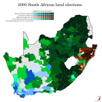
At this point in time, not all of South Africa was included in a local municipality. Significant chunks of land, mainly national parks but also some sparsely populated rural areas (especially in the Cape provinces), were established as District Management Areas (DMAs), in which the district council would provide services directly. None of these had more than a few thousand people in them, but they were in fact still inhabited and their inhabitants did have the right to vote for the district councils. I've been unable to find results for the district council elections - and indeed separate ward and PR results for the local municipalities, I believe the ECSA's website lumps them together - and so the DMAs are shown in light grey on this map.

The first elections to these new bodies, as mentioned before, were held in December 2000. This is right in the middle of the "Peak ANC" era - Nelson Mandela had just left office, the opposition was in shambles, and everyone was still too caught up by the victory over apartheid to worry about how the ANC were actually doing in government. In the general elections held the previous year, the party got 66.3% of the vote, an absolutely insane share in a multi-party democracy, and no other party hit 10%. In the local elections, the ANC would get a relatively paltry 59%, but they still won overall majorities in 162 municipalities and were virtually unopposed across Limpopo, Mpumalanga and large swathes of the North West, the Eastern Cape and the Free State.

The 2000 local elections were also the first outing for the newly-formed Democratic Alliance, a merger of the old Democratic Party, which had formed the liberal opposition in the apartheid-era parliament, and the New National Party, the successors to the (relatively liberal faction of the) governing National Party. The NNP would pull out of the coalition in 2001, but after it entered coalition with the ANC and promptly collapsed, most of its voters went to the DA anyway. It's quite hard to compare voteshares between 1995 and 2000 given how different the electoral systems and structures were, but in raw percentage terms the DA managed to just about match the result of its predecessors, which must be considered a good performance given the DP's weakness in 1995. They won pluralities across 18 councils, mainly in the Western Cape, and won overall control of twelve councils including the Cape Town metro.

The other major forces in this election were both descended from former bantustan governments. The more successful of these by quite far was the Inkatha Freedom Party, which is named for the iNkatha, the grass crown of the old Zulu Empire. The party had been founded by Mangosuthu Buthelezi, the hereditary chief advisor to the Zulu king, to bolster his authoritarian rule over the bantustan of KwaZulu. It quickly became the single largest political movement among the Zulu population, beating out even the ANC, but its role as a support organisation for the bantustan government made it - and Buthelezi personally, it's quite hard to draw a distinction between him and the party - deeply controversial then and now. It organised Zulu resistance against apartheid through the 1980s and early 90s, bringing it into conflict with the more pluralistic ANC on a number of occasions, and when apartheid ended it carried on as a party supporting federalism, official recognition of traditional African (and especially Zulu) leadership structures, and a stricter criminal justice system. It's unquestionably a conservative party, but it denies being right-wing, citing its middle-of-the-road economic policy in particular, and at this point it was in coalition with the ANC at the national level, with Buthelezi serving as Home Affairs Minister.

The only other party to win a plurality in any council was the United Democratic Movement, founded by former Defence Minister Roelf Meyer and General Bantu Holomisa, who had been military dictator of the Transkei bantustan from 1987 to 1994. Transkei was quite possibly the weirdest bantustan - it was the biggest one to have any kind of territorial integrity, and this made it a little bit less dependent on South Africa than the other ones. As a result, its leadership frequently clashed with Pretoria, including one point in the late 70s where Transkei broke diplomatic relations with South Africa. During Holomisa's leadership, the state became a safe haven for the ANC, and he came out slightly less tainted than most of the other bantustan leaders as a result. He was nevertheless forced out of the ANC in 1996 after accusing a fellow party member of corruption in front of the Truth and Reconciliation Commission, and founded the UDM as a new multiracial party that could break through the divisions of post-apartheid South Africa. They did reasonably well in the 1999 general election, winning about 4% of the vote, but then entered a long period of decline - the one council they won control of, the King Sabata Dalindyebo municipality in the heart of the former Transkei, was lost at the next election, and although Holomisa is still an MP, he's had fewer and fewer colleagues with each successive election.

val-za-l-2000.png
 
The first local elections held under universal suffrage in South Africa were in November 1995, although boundary disputes saw polling delayed for six months in KwaZulu-Natal and the Western Cape. I've not been able to map these as they were held on transitional boundaries that saw many of the old local bodies continue to exist until it could be decided what was to be done with them. Well, by the next elections in 2000, they had mostly figured it out, and only one transitional body - that of the all-white intentional community of Orania in the Northern Cape - kept existing after these elections.

The system settled on was largely two-tiered, with 53 district (Category C) municipalities and just over two hundred local (Category B) municipalities covering most small towns and rural areas, while the six biggest urban areas (Pretoria, Johannesburg, the East Rand (Ekurhuleni), Cape Town, Port Elizabeth and Durban) received metropolitan (Category A) municipalities that would exercise all local government powers over them. All local and metropolitan municipalities have a council elected by MMP, with half the seats elected in single-member wards and the other half drawn from party lists to ensure overall proportionality. This was seen as a suitable compromise between representation for ethnic and political minority groups on the one hand and the long tradition of local community representation in local government on the other. District councils function somewhat similarly, but only the proportional element is elected directly, with the other half of the seats drawn from the membership of local councils within the district.

At this point in time, not all of South Africa was included in a local municipality. Significant chunks of land, mainly national parks but also some sparsely populated rural areas (especially in the Cape provinces), were established as District Management Areas (DMAs), in which the district council would provide services directly. None of these had more than a few thousand people in them, but they were in fact still inhabited and their inhabitants did have the right to vote for the district councils. I've been unable to find results for the district council elections - and indeed separate ward and PR results for the local municipalities, I believe the ECSA's website lumps them together - and so the DMAs are shown in light grey on this map.

The first elections to these new bodies, as mentioned before, were held in December 2000. This is right in the middle of the "Peak ANC" era - Nelson Mandela had just left office, the opposition was in shambles, and everyone was still too caught up by the victory over apartheid to worry about how the ANC were actually doing in government. In the general elections held the previous year, the party got 66.3% of the vote, an absolutely insane share in a multi-party democracy, and no other party hit 10%. In the local elections, the ANC would get a relatively paltry 59%, but they still won overall majorities in 162 municipalities and were virtually unopposed across Limpopo, Mpumalanga and large swathes of the North West, the Eastern Cape and the Free State.

The 2000 local elections were also the first outing for the newly-formed Democratic Alliance, a merger of the old Democratic Party, which had formed the liberal opposition in the apartheid-era parliament, and the New National Party, the successors to the (relatively liberal faction of the) governing National Party. The NNP would pull out of the coalition in 2001, but after it entered coalition with the ANC and promptly collapsed, most of its voters went to the DA anyway. It's quite hard to compare voteshares between 1995 and 2000 given how different the electoral systems and structures were, but in raw percentage terms the DA managed to just about match the result of its predecessors, which must be considered a good performance given the DP's weakness in 1995. They won pluralities across 18 councils, mainly in the Western Cape, and won overall control of twelve councils including the Cape Town metro.

The other major forces in this election were both descended from former bantustan governments. The more successful of these by quite far was the Inkatha Freedom Party, which is named for the iNkatha, the grass crown of the old Zulu Empire. The party had been founded by Mangosuthu Buthelezi, the hereditary chief advisor to the Zulu king, to bolster his authoritarian rule over the bantustan of KwaZulu. It quickly became the single largest political movement among the Zulu population, beating out even the ANC, but its role as a support organisation for the bantustan government made it - and Buthelezi personally, it's quite hard to draw a distinction between him and the party - deeply controversial then and now. It organised Zulu resistance against apartheid through the 1980s and early 90s, bringing it into conflict with the more pluralistic ANC on a number of occasions, and when apartheid ended it carried on as a party supporting federalism, official recognition of traditional African (and especially Zulu) leadership structures, and a stricter criminal justice system. It's unquestionably a conservative party, but it denies being right-wing, citing its middle-of-the-road economic policy in particular, and at this point it was in coalition with the ANC at the national level, with Buthelezi serving as Home Affairs Minister.

The only other party to win a plurality in any council was the United Democratic Movement, founded by former Defence Minister Roelf Meyer and General Bantu Holomisa, who had been military dictator of the Transkei bantustan from 1987 to 1994. Transkei was quite possibly the weirdest bantustan - it was the biggest one to have any kind of territorial integrity, and this made it a little bit less dependent on South Africa than the other ones. As a result, its leadership frequently clashed with Pretoria, including one point in the late 70s where Transkei broke diplomatic relations with South Africa. During Holomisa's leadership, the state became a safe haven for the ANC, and he came out slightly less tainted than most of the other bantustan leaders as a result. He was nevertheless forced out of the ANC in 1996 after accusing a fellow party member of corruption in front of the Truth and Reconciliation Commission, and founded the UDM as a new multiracial party that could break through the divisions of post-apartheid South Africa. They did reasonably well in the 1999 general election, winning about 4% of the vote, but then entered a long period of decline - the one council they won control of, the King Sabata Dalindyebo municipality in the heart of the former Transkei, was lost at the next election, and although Holomisa is still an MP, he's had fewer and fewer colleagues with each successive election.

View attachment 72980
Very nice summary.

I quite like Holomisa and I considered voting for the UDM in the past but they're a bit weird now, still have pockets of support in the Eastern Cape, but nowhere really.

They also sometimes support the ANC in municipal colaitions and sometimes the DA. When a DA-coalition won Nelson Mandela Bay (Port Elizabeth) after the 2016 election, a UDM guy was deputy mayor under the DA's Athol Trollip (Trollip is now an ActionSA guy, and someone I still have quite a lot of respect for), and he was a very strange chap. I can't remember the details (or his name, Bobani maybe?) but I remember claims that he was incredibly corrupt and had links to criminal syndicates (don't quote me on that).
 
The first local elections held under universal suffrage in South Africa were in November 1995, although boundary disputes saw polling delayed for six months in KwaZulu-Natal and the Western Cape. I've not been able to map these as they were held on transitional boundaries that saw many of the old local bodies continue to exist until it could be decided what was to be done with them. Well, by the next elections in 2000, they had mostly figured it out, and only one transitional body - that of the all-white intentional community of Orania in the Northern Cape - kept existing after these elections.

The system settled on was largely two-tiered, with 53 district (Category C) municipalities and just over two hundred local (Category B) municipalities covering most small towns and rural areas, while the six biggest urban areas (Pretoria, Johannesburg, the East Rand (Ekurhuleni), Cape Town, Port Elizabeth and Durban) received metropolitan (Category A) municipalities that would exercise all local government powers over them. All local and metropolitan municipalities have a council elected by MMP, with half the seats elected in single-member wards and the other half drawn from party lists to ensure overall proportionality. This was seen as a suitable compromise between representation for ethnic and political minority groups on the one hand and the long tradition of local community representation in local government on the other. District councils function somewhat similarly, but only the proportional element is elected directly, with the other half of the seats drawn from the membership of local councils within the district.

At this point in time, not all of South Africa was included in a local municipality. Significant chunks of land, mainly national parks but also some sparsely populated rural areas (especially in the Cape provinces), were established as District Management Areas (DMAs), in which the district council would provide services directly. None of these had more than a few thousand people in them, but they were in fact still inhabited and their inhabitants did have the right to vote for the district councils. I've been unable to find results for the district council elections - and indeed separate ward and PR results for the local municipalities, I believe the ECSA's website lumps them together - and so the DMAs are shown in light grey on this map.

The first elections to these new bodies, as mentioned before, were held in December 2000. This is right in the middle of the "Peak ANC" era - Nelson Mandela had just left office, the opposition was in shambles, and everyone was still too caught up by the victory over apartheid to worry about how the ANC were actually doing in government. In the general elections held the previous year, the party got 66.3% of the vote, an absolutely insane share in a multi-party democracy, and no other party hit 10%. In the local elections, the ANC would get a relatively paltry 59%, but they still won overall majorities in 162 municipalities and were virtually unopposed across Limpopo, Mpumalanga and large swathes of the North West, the Eastern Cape and the Free State.

The 2000 local elections were also the first outing for the newly-formed Democratic Alliance, a merger of the old Democratic Party, which had formed the liberal opposition in the apartheid-era parliament, and the New National Party, the successors to the (relatively liberal faction of the) governing National Party. The NNP would pull out of the coalition in 2001, but after it entered coalition with the ANC and promptly collapsed, most of its voters went to the DA anyway. It's quite hard to compare voteshares between 1995 and 2000 given how different the electoral systems and structures were, but in raw percentage terms the DA managed to just about match the result of its predecessors, which must be considered a good performance given the DP's weakness in 1995. They won pluralities across 18 councils, mainly in the Western Cape, and won overall control of twelve councils including the Cape Town metro.

The other major forces in this election were both descended from former bantustan governments. The more successful of these by quite far was the Inkatha Freedom Party, which is named for the iNkatha, the grass crown of the old Zulu Empire. The party had been founded by Mangosuthu Buthelezi, the hereditary chief advisor to the Zulu king, to bolster his authoritarian rule over the bantustan of KwaZulu. It quickly became the single largest political movement among the Zulu population, beating out even the ANC, but its role as a support organisation for the bantustan government made it - and Buthelezi personally, it's quite hard to draw a distinction between him and the party - deeply controversial then and now. It organised Zulu resistance against apartheid through the 1980s and early 90s, bringing it into conflict with the more pluralistic ANC on a number of occasions, and when apartheid ended it carried on as a party supporting federalism, official recognition of traditional African (and especially Zulu) leadership structures, and a stricter criminal justice system. It's unquestionably a conservative party, but it denies being right-wing, citing its middle-of-the-road economic policy in particular, and at this point it was in coalition with the ANC at the national level, with Buthelezi serving as Home Affairs Minister.

The only other party to win a plurality in any council was the United Democratic Movement, founded by former Defence Minister Roelf Meyer and General Bantu Holomisa, who had been military dictator of the Transkei bantustan from 1987 to 1994. Transkei was quite possibly the weirdest bantustan - it was the biggest one to have any kind of territorial integrity, and this made it a little bit less dependent on South Africa than the other ones. As a result, its leadership frequently clashed with Pretoria, including one point in the late 70s where Transkei broke diplomatic relations with South Africa. During Holomisa's leadership, the state became a safe haven for the ANC, and he came out slightly less tainted than most of the other bantustan leaders as a result. He was nevertheless forced out of the ANC in 1996 after accusing a fellow party member of corruption in front of the Truth and Reconciliation Commission, and founded the UDM as a new multiracial party that could break through the divisions of post-apartheid South Africa. They did reasonably well in the 1999 general election, winning about 4% of the vote, but then entered a long period of decline - the one council they won control of, the King Sabata Dalindyebo municipality in the heart of the former Transkei, was lost at the next election, and although Holomisa is still an MP, he's had fewer and fewer colleagues with each successive election.

View attachment 72980
Great work as always Max. Very stark east-west divide there, which wouldn't be as visible in the usual winner-only maps one sees.
 
South Africa: Election results in Cape Town, 1910-53 (incomplete)
Fuck it, I may as well share a bit of what myself and the Davids have been cooking up. As some of you may have divined, we've been looking into finding results and boundaries for the South African parliamentary elections held before and during apartheid, which if successful would fill one of the most glaring holes in online electoral cartography. It very much remains to be seen how far we'll get in this - it turns out there's a reason why no one's been able to do this before us - but @Nanwe has been able to obtain a book that has all the results up to 1977, so at the very least we should be able to get the non-mapping side of the equation sorted given enough time.

As for the maps themselves, well, someone on Wikipedia has been able to make a map of the very first election, held in 1910, and the boundary commission report for 1915 is on Wikimedia Commons as well, but unfortunately the scan they have excludes the appendix with all the maps. So all I've been able to do with that is draw in most of the boundaries in major urban areas, and then guess the remaining ones. This, too, has been my approach with the gazettes we've recovered from the digitisation project at gazettes.africa, which have full boundary descriptions for the 1924, 1943, 1953 and 1981 delimitations, but again, no maps. Rural areas are also very hard to make anything of - the 1915 report uses field cornetcies (the third-level division between provinces and magisterial districts) as its basis for the most part, but I've only found boundaries for those in a few districts of the Cape Province, and for all the subsequent reports the constituencies are defined by which pre-existing polling districts they contain, and if those districts are themselves defined it's by reference to survey marks and property owners which are utterly impossible to track down.

So what I have been able to do is fragmented and largely confined to cities. With that in mind, here's the seats for Cape Town in the aforementioned delimitations, with the exception of 1981 which I haven't gotten to yet. In 1910, four seats were created for Cape Town proper: Central, covering the blocks immediately surrounding the Parliament Buildings as well as the Bo-Kaap area; Castle, which covered points east including the Castle of Good Hope as well as District Six; Gardens, which covered the entire southern half of the City Bowl including its namesake neighbourhood and the Company's Gardens themselves; and Harbour, which covered the waterfront as well as the Green Point and Sea Point suburbs along the coast to the west of the city. In addition, the seats of Liesbeek, Woodstock and Newlands were created to cover the city's growing suburbs.

In 1915, there wasn't much change to the seats in Cape Town proper, but Liesbeek was shifted north to become a semi-rural seat covering much of the east shore of Table Bay (moving it out of our inset in the process), and Woodstock became a smaller seat that was much more focused on its namesake suburb. To cover the rest of the former Liesbeek seat, the new seat of Rondebosch was created, and Newlands shifted ever so slightly south to ensure all of Rondebosch was in its namesake seat.

1920 saw the new seat of Salt River created to cover Liesbeek's more urban parts, but as mentioned, I don't have those boundaries, so we skip forward to 1924, at which point there's been substantial change inside Cape Town itself. Central has become an even smaller seat geographically, giving up Bo-Kaap to Gardens, while Salt River has moved west to include a substantial area inside Cape Town's city line, including the Castle. As a result, the Castle seat is renamed Hanover Street, a name it would only carry for this one election, and Woodstock has been entirely split between Salt River, Rondebosch and Liesbeek. The two suburban seats are otherwise not changed substantially from 1915.

By 1943, things have changed substantially. The absolute dead centre of Cape Town is no longer populous enough to support a seat and change, and so Central has been abolished. Harbour, meanwhile, has been split into the new seats of Green Point and Sea Point, neither of which carry the Cape Town prefix even though Green Point includes a large chunk of the CBD. Woodstock is back, meanwhile - its abolition was another oddity of 1924 that would be undone at the very next election - and shares the inner suburbs with Salt River and the new-ish (created in 1929) seat of Mowbray. To make way for Mowbray, Rondebosch shifted south to take in Newlands from 1933 on, and so the former Newlands seat is now called Claremont instead. The suburbs south of it have also grown enough to get a seat of their own, which is named Wynberg and stretches not quite all the way down to False Bay. The old South Peninsula seat, which is too big for the inset, has also been split in half, with the new Cape Flats seat covering the areas east of the suburban seats.

In 1953, there's been further suburbanisation, with Woodstock once again abolished (for good this time) and Mowbray shifted northeast and renamed Maitland (another Maitland seat had existed previously, in the 30s, though I suspect this would've been too large for the inset as well). The new seat of Pinelands has been created to cover what had been the eastern part of Rondebosch and the northwest corner of Cape Flats, and Rondebosch has dipped even further south to take in Claremont. The Claremont seat is thus once again renamed to Constantia, a name it would retain for the rest of the FPTP era.

So that's a lot of detail on the seats themselves, but what about the politics? Well, Cape Town was always quite boring on that front. The city was a stronghold of the "imperialist" (i.e. staunchly pro-British) faction, represented first by the Unionist Party, then (after the realignment caused by Hertzog's National Party gaining strength among Afrikaners) by the South African Party, and then by the United Party from the 30s onwards. There were a couple of seats (including Liesbeek in 1915 and Salt River in 1924) won by Labour, but generally, the fact that (unlike in Johannesburg) the right was very strongly united in Cape Town meant they had very little success. In 1943 and 1953, the United Party won every seat in the city, and this would continue to be the pattern until the 60s - even then, the older (and wealthier) suburbs depicted on these maps would keep voting for the liberal opposition right up to 1989. The Nationalist strongholds in Cape Town were mainly in the working-class suburbs of the Cape Flats and the foothills east of them, although Wynberg was very narrowly won by them in 1987.


Hi8KNNQ.png


EDIT: I realised when typing up the description that I have Woodstock and Liesbeek the wrong way around on the 1910 map. Just imagine Woodstock is in the paler green and Liesbeek in the darker one.
 
Last edited:
Excellent detective work, you lot.
Fantastic work--I'm very eager to see how far you guys can go in finally filling this gap. South Africa has to be one of the only G20 nations left that doesn't have a solid, historical electoral map database online.
Which reminds me of how much we've come on in a decade or so, because when I first started getting interested in psephology in 2010, I don't think any of them had one (or at least not a publicly accessible one). It was all hobbyists on places like the Dave Leip forum.
 
Which reminds me of how much we've come on in a decade or so, because when I first started getting interested in psephology in 2010, I don't think any of them had one (or at least not a publicly accessible one). It was all hobbyists on places like the Dave Leip forum.
The only consistent place for election maps that I remember back when I was in undergrad (~2007-2011) was Adam Carr's website, and he didn't map every country who he gathered statistics for (and now has scaled back to just Australia and state elections). Now there's plenty of people and it's made information-finding so much easier when you're interested in elections as either a hobby or a profession.
 
Fantastic work--I'm very eager to see how far you guys can go in finally filling this gap. South Africa has to be one of the only G20 nations left that doesn't have a solid, historical electoral map database online.
It’s reasonable that this isn’t a part of their history that they’re proud of, but like, there’s plenty of maps around of the German election of 1933.
 
It’s reasonable that this isn’t a part of their history that they’re proud of, but like, there’s plenty of maps around of the German election of 1933.

I wonder if it's more related to how elections seem to become a lot less important the moment the National Party rule consolidated after 1948. Which mind you is crazy how that happened considering how fluid SA politics remained before WWII.
 
I wonder if it's more related to how elections seem to become a lot less important the moment the National Party rule consolidated after 1948. Which mind you is crazy how that happened considering how fluid SA politics remained before WWII.
I think once apartheid was established and the vote finally, definitively restricted to whites, it was sort of inevitable that the main area of political conflict would move from Parliament to the streets. Before 1948 there was a notion that South African democracy was actually real and reflected the genuine political climate of the country as a whole, but from the 50s onwards, it became clear that it was all a charade and, depending on where you were politically, either the opposition was illegitimate as long as it didn’t push for majority rule (which, of course, the UP was never interested in doing), or the government was engaged in a life-or-death struggle to save South Africa from black communism and anyone who wasn’t fully on board was a traitor to the nation.
 
I guess the UP was in large part the personality-based party of Jan Smuts, so after his insanely long political career came to an end it went through the trouble those sorts of parties get into, compounded with the NP being perfectly happy to push the knife by messing with the electorate and constitution. And moderate white supremacy was never going to do well against the real thing.
 
I guess the UP was in large part the personality-based party of Jan Smuts, so after his insanely long political career came to an end it went through the trouble those sorts of parties get into, compounded with the NP being perfectly happy to push the knife by messing with the electorate and constitution. And moderate white supremacy was never going to do well against the real thing.
There's a really good anecdote about the 1948 election where Jan Smuts is disconsolate about the result in the Transvaal and says something along the lines of "Have all my old comrades abandoned me?" - to which his interlocutor's response is "No, Jannie, they're all dead, it's their grandkids that are voting against you".
 
South Africa: Election results in Cape Town, 1981/87 (incomplete)
Here's what I've been able to parse of the 1981 boundaries. The Cape Flats and the other outer suburbs are very hard to do, because many polling district boundaries aren't defined and a lot of the rest were defined by cadastral divisions (erfs - a word I now associate with trauma) and other property lines I can't reliably trace on the map. There were two more seats east of Vasco - Parow and Bellville - which were small enough that they should go in the inset. Also worth noting that many of the outer boundaries are guesswork.

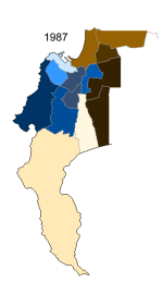
Election results are for 1987, but AFAICT there were no boundary changes between the two. Or at least no seats were created or dissolved. You can see the divide between the older, inner suburbs, which were largely affluent, English-speaking and voted for the PFP, and the more working-class Afrikaner suburbs in the east. Simonstown had been lost to the Nationals in 1981 after its incumbent MP went over to the disastrous South African Party refoundation, and both it and Wynberg were excruciatingly close losses in straight NP-PFP races. Green Point was almost won by the NP as well, and this despite the fact that Walvis Bay, whose 4,000 or so bedrock National voters were part of Green Point in 1981, had been split off to form its own seat.

1694556386125.png
 
Last edited:
I think once apartheid was established and the vote finally, definitively restricted to whites, it was sort of inevitable that the main area of political conflict would move from Parliament to the streets. Before 1948 there was a notion that South African democracy was actually real and reflected the genuine political climate of the country as a whole, but from the 50s onwards, it became clear that it was all a charade and, depending on where you were politically, either the opposition was illegitimate as long as it didn’t push for majority rule (which, of course, the UP was never interested in doing), or the government was engaged in a life-or-death struggle to save South Africa from black communism and anyone who wasn’t fully on board was a traitor to the nation.

Hmm, I'm not sure about that. I think there was already widespread resentment pre-1948 regarding the exclusion of black South Africans from political life. Some of the most heinous and racist legislation was put in place long before 1948, the 1913 Land Act, for example.

I don't think there was really much material difference in the life of a black South African, pre- and post-1948, and I don't think black South Africans would have considered a pre-1948 government anymore legitimate than a post-1948 one.
I should’ve maybe specified “among whites” - you are of course right, and I didn’t mean to imply that apartheid came out of nowhere. What I meant was that there could be a degree of parliamentary competition before 1948 (or perhaps more accurately before some vague point in the 50s) because it was easier for both the electorate and the political class to maintain illusions as to how real South African democracy was.
 
Back
Top