• Hi Guest!

    The costs of running this forum are covered by Sea Lion Press. If you'd like to help support the company and the forum, visit patreon.com/sealionpress

Max's election maps and assorted others

U.S. House 1912 (Socialist voteshare map)
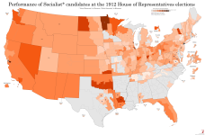
The Progressives weren't the only ones trying to break the two-party system from the left in 1912. In 1901, a convention of left-wing activists from numerous different groups met in Indianapolis and founded the Socialist Party of America, a broad-tent socialist movement that was intended to be the US parallel to organisations like the SPD in Germany or the Labour Party in the UK. Like them, it encompassed a broad range of opinion, from the "Sewer Socialists" of Milwaukee who largely fought for improved public services (hence the name) and didn't differ too much from the Progressives in matters of policy, through Christian prairie radicals like Julius Wayland and Oscar Ameringer, to out-and-out Marxists like Eugene Debs and the other organisers of the International Workers of the World. The party would, in fact, spend most of its existence riven with internal strife over issues like how (and to some extent whether) to oppose racial segregation, whether to focus on electoral politics or syndicalist union organising as a path to power, and most famously, whether to oppose the US joining World War I.

The fact that the SPA, unlike most mainstream socialist movements in Europe, would come out in full force against the war, and suffer a large amount of state repression as a result, has its explanation in the party's support base. One of its key demographics were immigrant labourers in the mid-sized cities of the North, many of whom had German or Austro-Hungarian origins and were none too keen to see their new homeland go to war against their old one. On the map below, we can see how many of their biggest strongholds - Schenectady, Dayton, Terre Haute, Duluth, Oakland - fit this mould, which incidentally looks a lot like the Labour base at the same time. The only major cities where the Socialists achieved any kind of strength were Chicago and Pittsburgh, which were both also extremely multicultural working-class cities at this time. Milwaukee, the most notable Socialist stronghold, fell somewhere in between the two, being a very large city but also having a solid German-speaking population bloc that would form the main base of Sewer Socialism for the next several decades.

The other Socialist base, which arguably looks more impressive at least on this map, were miners and subsistence-level farmers in the West, many of whom lived on the edge of starvation and were treated horribly by their employers (or produce buyers and landlords, in the case of small farmers), and so found a natural attraction to the idea of changing the economic structure of society. Perhaps surprisingly to modern observers, the single strongest state for the SPA in much of the 1910s was Oklahoma. The reason for this traces back to the Land Runs of 1889-95, where Congress revoked tribal titles to the land that had been Indian Territory, causing a flood of white settlers from neighbouring regions who were eager to claim a piece of the American frontier before it closed for good. Because of the lack of preparedness of many of these settlers and the specific conditions of their arrival, a large majority found themselves either destitute or one bad harvest away from destitution, and this made the then-territory fertile ground for Populist, and later Socialist, organising. Many of the settlers found a temporary solution to their desperate situation in selling their land claims to railroads or other big businesses and leasing it back, which only ended up sending them further into poverty and further into radicalisation. The Socialist Party of Oklahoma, at its peak, commanded the support of some 20% of the electorate, but suffered a particularly brutal crackdown after 1917 and never really returned to prominence.

As far as I know, 1912 was the best Socialist performance in any US federal election, in spite of the fact that they won no seats. Eugene Debs, who was nominated as the SPA's candidate for President on a cross-faction unity ticket with Sewer Socialist Emil Seidel, won just shy of 6% of the popular vote, but the party's congressional candidates actually outdid him by some margin, winning 7.9% of the vote across 335 candidates - one of the largest slates put up by a third party in the 20th century, and more than half again as many as the Progressives. Then again, this broad slate of candidates may have hurt the party as much as it helped, because again, none of them got elected. This illustrates pretty clearly the difference between Progressive and Socialist paths to power - one was a top-down movement of reformist politicians and concerned high-profile citizens, with a large amount of name recognition for their leading figure(s) and a severe lack of ground game, while the other was a bottom-up movement of trade unionists and agitators who gathered a large organising base but was only able to break through in the few places where they obtained prominence.

The SPA would only ever send two representatives to Congress, though never more than one at a time, and as mentioned, neither won their seat in the party's best election. Victor Berger, one of the leading Sewer Socialists, had won election to Congress from the north side of Milwaukee (WI-5) in 1910, but was defeated in his bid for re-election by Republican candidate W. H. Stafford - the two would alternate in the seat until 1933. The other Socialist congressman was Meyer London, who won his seat on the Lower East Side of Manhattan (NY-12) in 1914 and served three non-consecutive terms ending in 1923, but his time had still not come in 1912 as the Democratic incumbent held the seat.
val-us-1912-soc.png
 
I've been working on a project with @Nanwe and @Uhura's Mazda which you'll no doubt be seeing more of relatively soon, but for now, have a preview of sorts.

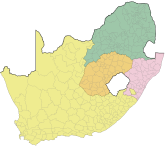
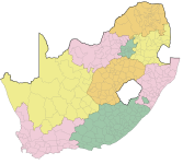
These maps show the magisterial districts of South Africa as of the 1994 elections, with the four old provinces and the nine new ones created after the elections. The districts, as far as I understand, weren't local government units in their own right, but served as local judicial districts (hence the name - each one was home to a magistrates' court) and were used for a number of other administrative functions. One notable such thing were banning orders, one of the most infamous aspects of apartheid-era South African law, which required an individual to stay within their local district and to report weekly to the local police station, among other restrictions. This provided a more targeted complement to the Pass Laws, which restricted the movement of entire ethnic groups, allowing the state to very effectively police and persecute its internal opponents.

Anyway, this was all being done away with by 1994, and the districts were as well. What these maps actually show are two steps in a long transitional process that lasted through most of the 1990s, beginning with the dissolution of the bantustans and ending with the 2000 local elections and the establishment of the modern system of district, local and metropolitan municipalities.

1693315346500.png

1693313751011.png
 
I've been working on a project with @Nanwe and @Uhura's Mazda which you'll no doubt be seeing more of relatively soon, but for now, have a preview of sorts.
Very nice work. I might be showing ignorance of South African politics in this period here, but could these be used to map the 1994 elections and prior? I'm not aware if they formed any of the boundaries of the apartheid-era constituencies or counting areas for 1994, but either would be fascinating to see if so.
 
Very nice work. I might be showing ignorance of South African politics in this period here, but could these be used to map the 1994 elections and prior? I'm not aware if they formed any of the boundaries of the apartheid-era constituencies or counting areas for 1994, but either would be fascinating to see if so.

Finding constituency maps for pre-1994 South Africa is, as I understand it, one of the great Holy Grail quests for the mapping and alternate history communities. I've never seen an actual one online anywhere, though I have seen one or two proposals for if modern-day South Africa adopted FPTP/AV or STV with small district magnitudes. If I had to guess, there probably is one lying in an archive or library somewhere in the country itself, but unless I've missed it, it's never been scanned and/or uploaded. And I looked quite a bit back in grad school while trying to work out the precise boundaries of Helen Suzman's constituency (she was the only anti-apartheid MP for many years, but I could never figure out where precisely her seat started and ended).

Eugene Debs, who was nominated as the SPA's candidate for President on a cross-faction unity ticket with Sewer Socialist Emil Seidel, won just shy of 6% of the popular vote, but the party's congressional candidates actually outdid him by some margin, winning 7.9% of the vote across 335 candidates - one of the largest slates put up by a third party in the 20th century, and more than half again as many as the Progressives.

Victor Berger, one of the leading Sewer Socialists, had won election to Congress from the north side of Milwaukee (WI-5) in 1910, but was defeated in his bid for re-election by Republican candidate W. H. Stafford - the two would alternate in the seat until 1933.
Milwaukee was fertile territory for the Socialist Party right up until about 1960. Seidel himself was Mayor of the city when he accepted the slot as Debs' running mate, having lost his re-election bid earlier that year. They then elected another Socialist, Daniel Hoan, for a whopping six terms from 1916 to 1940; Hoan was a close ally to none other than Victor Berger, the two having come up in municipal politics together. Hoan got unseated in 1940 in an upset, and the guy who beat him (Carl Zeidler, a Democrat) promptly quit to fight in WWII where he died.

The interim mayor won a term of his own and then lost in 1948 to Frank Zeidler, brother of the aforementioned Carl though obviously of very different political beliefs, who went on to serve through 1960. He probably could have won another term, but the political opposition in the city ginned up a phony race-relations controversy, accusing him of bussing Black people from the South into the still very white city. Combine a fake news story with the national race-relations climate, and you get the potential for some really ugly politics. The phony scandal got business and, crucially for a Socialist mayor, labor into quite the lather and he ultimately bowed out. And ever since, there has yet to be a major US city run by a registered or self-proclaimed socialist (unless we count Burlington, VT under Bernie Sanders, but that stretches the definition of "major" IMO).*

As to why Milwaukee was such a fertile territory for the socialist movement, it's threefold (aside from the WWI era reasons Ares already outlined above!!). One, immigration to the city was largely northern German where the SPD had already organized and become popular, and two, many of its Jewish residents came from the socialist Bundist tradition in Galicia-Lodomeria and other parts of Eastern Europe. Third, add to that an already strong labor movement from the fact Milwaukee was then an economic/manufacturing center, and the fact it wasn't as populous as say, NYC, and you get a recipe for a strong left-wing presence in local politics.

*Watch this space? With the way the DSA has done in local elections the past few electoral cycles, it's no longer inconceivable that a major (almost certainly Northeastern or Upper Midwestern) city could have a socialist-identifying mayor in a short span of time.
 
Finding constituency maps for pre-1994 South Africa is, as I understand it, one of the great Holy Grail quests for the mapping and alternate history communities. I've never seen an actual one online anywhere, though I have seen one or two proposals for if modern-day South Africa adopted FPTP/AV or STV with small district magnitudes. If I had to guess, there probably is one lying in an archive or library somewhere in the country itself, but unless I've missed it, it's never been scanned and/or uploaded. And I looked quite a bit back in grad school while trying to work out the precise boundaries of Helen Suzman's constituency (she was the only anti-apartheid MP for many years, but I could never figure out where precisely her seat started and ended).
There is actually one on Wikipedia for the 1989 election now, but there isn't a source and from what I gather this was only used in 1989 so it's not much help for the earlier elections. Plus it's only for the House of Assembly (which was the one that had all the power under apartheid, but still, it would be interesting to see how the Houses of Representatives and Delegates voted too).

As you say, it's a real shame not only for alternate history but also for actual history- I for one would be very interested to find out the details of things like how bad the rural malapportionment that let National get into power despite losing the popular vote in 1948 was and how the Indian and coloured voters voted in their designated houses versus for the National Assembly.
 
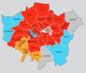
Something I thought might be appreciated by people who post here - I discovered the Local Government Chronicle does annual council control maps, the latest being here (opens as a PDF).

I don't know how this happened, but somehow, amid this rather detailed and interesting attempt to cover the UK's complex local government, they have inexplicably given Croydon the borders it had from 1965 to 1969 and never since?

1693411743916.png


Fetch @Meadow, I smell a conspiracy.
 
Something I thought might be appreciated by people who post here - I discovered the Local Government Chronicle does annual council control maps, the latest being here (opens as a PDF).

I don't know how this happened, but somehow, amid this rather detailed and interesting attempt to cover the UK's complex local government, they have inexplicably given Croydon the borders it had from 1965 to 1969 and never since?

View attachment 72658


Fetch @Meadow, I smell a conspiracy.
what have they done to my son

feed him
 
There is actually one on Wikipedia for the 1989 election now, but there isn't a source and from what I gather this was only used in 1989 so it's not much help for the earlier elections. Plus it's only for the House of Assembly (which was the one that had all the power under apartheid, but still, it would be interesting to see how the Houses of Representatives and Delegates voted too).

As you say, it's a real shame not only for alternate history but also for actual history- I for one would be very interested to find out the details of things like how bad the rural malapportionment that let National get into power despite losing the popular vote in 1948 was and how the Indian and coloured voters voted in their designated houses versus for the National Assembly.
This is all extremely relevant to our project, don’t worry.
 
Something I thought might be appreciated by people who post here - I discovered the Local Government Chronicle does annual council control maps, the latest being here (opens as a PDF).

I don't know how this happened, but somehow, amid this rather detailed and interesting attempt to cover the UK's complex local government, they have inexplicably given Croydon the borders it had from 1965 to 1969 and never since?
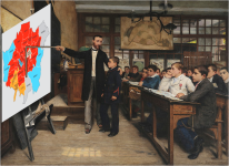
Sorry for how idiotic this is but this was my first thought:
1693415211297.png
This is all extremely relevant to our project, don’t worry.
Oh really? That's exciting to hear then!
 
Something I thought might be appreciated by people who post here - I discovered the Local Government Chronicle does annual council control maps, the latest being here (opens as a PDF).

I don't know how this happened, but somehow, amid this rather detailed and interesting attempt to cover the UK's complex local government, they have inexplicably given Croydon the borders it had from 1965 to 1969 and never since?

View attachment 72658


Fetch @Meadow, I smell a conspiracy.

Actually looking more widely, they appear to just be using a map of Greater London in 1965. Bromley also has the bit that they lost in 1969, and the 1994 boundary changes aren't there either- see the big bite at the Enfield-Epping-Waltham Forest border, Barnet's triangular surge northwards and the area around Heathrow in particular. Plus skinny Barking and Dagenham, the little notch from Ealing into Hammersmith and Fulham etc.

Which just begs the question of why they're using that one.
 
Which just begs the question of why they're using that one.
Maybe they just started from the beginning and worked their way forward? I think they can be forgiven for assuming Greater London's boundaries have been the same since it was created, it's not like these things are all that widely publicised.
 
In another reply, you mentioned the British postwar consensus; believe it or not, there was an uneasy but very real "post-Roe consensus" in American politics for most of the 1970s. Most of the anti-abortion muscle and power went into defeating the Equal Rights Amendment before turning back to the actual abortion debate in the 1980s and the run up to Planned Parenthood v. Casey (the case that first started to chip away at the broad ruling in Roe v. Wade).
Also, this was helped/hurt by the divisions of the pro-life movement between those forces (tacitly supoorted by the Catholic hierarchy) for rolling it back through vatious reforms and obtaining favorable judges, and a more radical wing (mostly led by lay activists, often to the exasperation of the hierarchy) which demanded the adoption of a Pro-Life Constitutional Amendment (which in turn was divided between those who wanted to start with merely status quo ante Roe, and those who wanted an Ireland-style amendment.)

The main gradualist organization was the National Right to Life Committee, while the radical faction's most prominent force was the American Life League.
 
Last edited:
Finding constituency maps for pre-1994 South Africa is, as I understand it, one of the great Holy Grail quests for the mapping and alternate history communities. I've never seen an actual one online anywhere, though I have seen one or two proposals for if modern-day South Africa adopted FPTP/AV or STV with small district magnitudes. If I had to guess, there probably is one lying in an archive or library somewhere in the country itself, but unless I've missed it, it's never been scanned and/or uploaded. And I looked quite a bit back in grad school while trying to work out the precise boundaries of Helen Suzman's constituency (she was the only anti-apartheid MP for many years, but I could never figure out where precisely her seat started and ended).
I have one for the 1989 General election for an alt-hist South Africa RPG/EG. If @Ares96 is Ok with it I can share it in this thread.
 
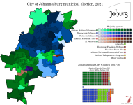
Johannesburg 2021
This is the first in what may end up becoming a series - I did a map of Cape Town ages ago, but there's been another election since then, so I'll have to go back and update it sometime.

Johannesburg Metropolitan Municipality had a population of 4.4 million as of the 2011 census, and it's likely to have grown by more than a million since then (the following census was delayed to 2022 due to COVID-19, and still hasn't been published). This number is especially impressive considering the city's boundaries, which, in spite of the general push to unify metropolitan areas following the end of apartheid, still stop a short distance east and south of the city centre. The East Rand area, covering a number of satellite cities and townships east of Johannesburg, was made into a separate metropolitan municipality, Ekurhuleni (a Tsonga word meaning "place of peace"), and a number of outer western suburbs were left out of the "unicity" as well. However, the municipality is still extremely diverse and divided, with both affluent suburbs like Houghton, Rosebank and Sandton and townships like the famous Soweto as well as Ivory Park and Alexandra. The latter, despite being one of the poorest and most densely-populated urban areas in all of South Africa, is surrounded by much wealthier areas, making one of few breaks in what's otherwise a very stark socioeconomic divide between the city's northern and southern suburbs. The CBD itself was reserved for whites during the apartheid era, as were most of the inner suburbs, but following the democratic breakthrough, most whites decamped the area leaving it impoverished and crime-ridden. Things have started to get better again, but revitalising the city core remains one of Johannesburg's major challenges.

The council, like the city it serves, is very large - with 270 elected councillors, I believe it's one of the largest local councils in the world, though I don't have a source to back that up. As with every other local council in South Africa, elections are held using MMP, with 135 councillors elected from single-member wards and another 135 assigned to party lists in such a way as to make the overall makeup of the council proportional to the share of votes cast for each party. Like all metropolitan municipalities aside from Cape Town, Johannesburg gave the ANC an overall majority of the council in its first election, and continued to do so until 2016, when the DA made big strides and nearly overtook the ANC in vote and seat share. Since then, Johannesburg City Council has been under no overall control, and things have only gotten more and more fractious over time. The DA's first mayor was Herman Mashaba, who founded a haircare company and earned millions of rand from it, leaving him with the firm conviction that anyone can now make it in South Africa and so all government intervention in the economy is a waste of time and money. He resigned in November 2019, citing differences with the DA leadership, and the ANC were able to claw back the mayoralty under Geoff Makhubo, who was himself deeply controversial because of alleged corruption, but was able to save himself from being forced out of office by the simple expedient of dying of COVID in July 2021. His successor, fellow ANC member Jolidee Matongo, was killed in a car accident two months later, and so the city went into the 2021 elections with an interim mayor.

As mentioned, the 2021 elections returned an even more unstable council than the 2016 ones, and this was largely due to the return of Herman Mashaba, who broke off from the DA after leaving the mayoralty and formed his own party called ActionSA (that's the full name of the party). The party's ideology largely mirrors Mashaba's own libertarian beliefs, supporting lower taxes and deregulation of business, and also agitates against illegal immigration from other African countries, which its supporters believe is responsible for nearly all of South Africa's economic and administrative issues, including crime, unemployment, stagnant wages and failure to deliver public services. This is of course not backed up by anything, but what's new. ActionSA ended up getting a slightly worrying 18% of the vote across the city, taking votes about equally from the ANC and the DA, although they failed to win a single ward. However, two wards in the south of the city were won by the Patriotic Alliance, a very similar (albeit less economically libertarian) group led by the incredibly-named Gayton McKenzie, a rags-to-riches figure somewhat similar to Mashaba except with a spicier backstory that involves spending time in prison for robbing banks and using this as material for a successful motivational speaking career. The Inkatha Freedom Party also won two wards in the heavily-Zulu inner suburbs of Jeppestown and Denver, heralding a return for the party that seems to be carrying on apace if current polls are anything to go by. Lastly, Al Jama-ah, a party for and by South Africa's Muslim community, won a ward on the southern edge of Soweto.

Al Jama-ah would become quite important to the development of Johannesburg's politics after the 2021 election, because when the DA-led rainbow coalition that took over after the election inevitably fell apart at the end of 2022, it was Thapelo Amad, one of their councillors, who became mayor with the support of the ANC and the EFF (who, by the way, maintained a steady 10-11% of the vote in both 2016 and 2021). Amad only lasted in office until April 2023, and his successor Kabelo Gwamanda collapsed during a debate in the council in June and had to be hospitalised. All is going well in the City of Gold.

val-za-2021-joburg.png
 
Last edited:
Please tell me the Speaker's name actually is Vasco da Gama and that isn't a placeholder. It would make my week.
It is indeed.

He isn't the speaker anymore though, lost his position to someone from another microparty, Colleen Makubhele from COPE. COPE has one seat in the 270 seat council (full disclosure I voted for COPE in the 2009 national election when they were still actually a coherent thing).
 
Back
Top