• Hi Guest!

    The costs of running this forum are covered by Sea Lion Press. If you'd like to help support the company and the forum, visit patreon.com/sealionpress

Makemakean Does Various Graphical Things!

This is going reaaaaally slow.

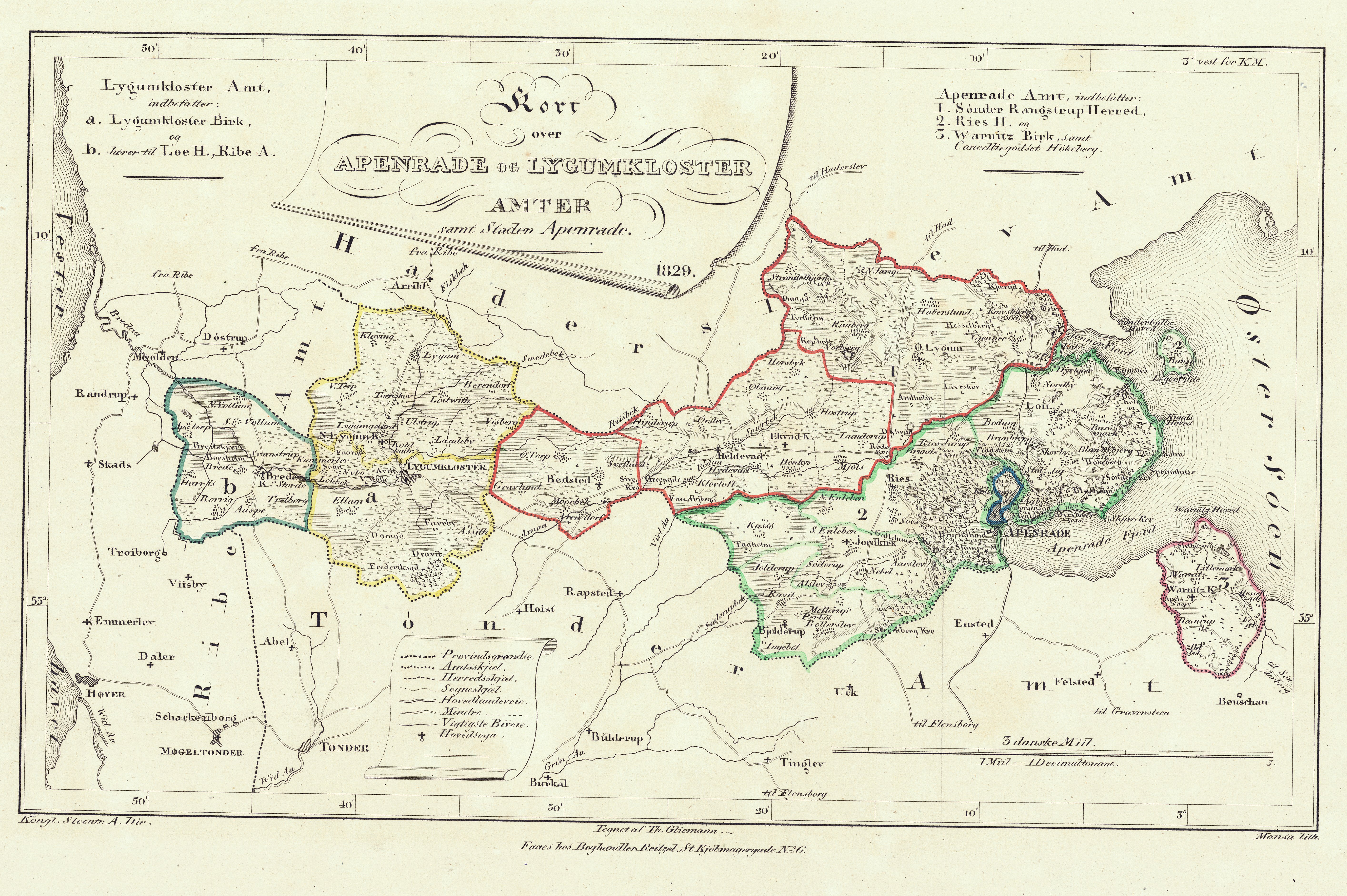
The problem is not that we don't know the borders of pre-Prussian Holstein, because we found a very good map of those, and problem is neither that we don't know the relative population data in each and every little amt and county and fideikommiss and once-upon-a-time-land-belonging-to-a-Catholic-monastery-then-the-Reformation-happened-but-it's-still-for-administrative-purposes-300-years-later-judged-ecclesiastical-land, because I did find a German geographical work quoting extensively from the Danish census of 1845 which does contain all this information.

The problem is the particular projection on the map we are using. The cartographer seems to have been cheating a little, and so, to get the borders, I essentially need to go into Google Maps, find all the places mentioned in the map close to a border, and then fit that border as closely as humanely possible given the information we have to the borders given on that map unto our map. And it takes forever.

Still, Lauenburg turned out to be relatively easy to partition into two parts with relatively equal population that wonderfully enough each one is big enough to be a single member constituency:

moreholsten.png

Also, turns out that the old amt of Ahrensbök first fell into the hands of the Grand Duchy of Oldenburg after the Prussians conquered the duchies of Schleswig, Holstein, and Lauenburg from Denmark, and was given to this power by the Prussians as compensation for land lost elsewhere. It meant that the Oldenburg claims in Holstein were contiguous, but since that has been butterflies away, Ahrensbök still remains Danish (well, Holsteiner) in this timeline. Also means that Eutin, i.e. the northern part of the Prince-Bishopric of Lübeck, which still falls into Oldenburger hands, becomes this interesting little landlocked enclave in the Nordic Empire.

I assume that Oldenburg is the one German principality which is closest diplomatically to the Nordic Empire. Not just is of course the Grand Duke of the same house as the Nordic Imperial Family, but with borders like these, it wouldn't be strange if they're also into some sort of customs unions. The Free Cities of Lübeck and Hamburg are each city-state republics. I like to envisage that Lübeck over time becomes this financial center of Northern Europe, with very lax tax laws and non-existent tariffs and customs, where they also allow for gambling and a whole bunch of other things that are yet illegal in the Nordic Empire. They also never reform their truly medieval mercantile way of running the place. A Baltic Monaco/Singapore/Hong Kong-hybrid.
 
The Hanseatic cities were actually extremely protective of their customs barriers, because those were their main source of income going back centuries - Hamburg and Lübeck were the very last territories to join the Zollverein, several years after the unification of the German Empire.

That said, they did yield in good time, and Hamburg eventually became famous for its free harbour where sailors from all over the world could trade freely, and the locals took advantage of the fact with some creativity.

Well, of course. Monaco was until the opening of the casino and so forth pretty much in a state of decline. I anticipate that around the first Nordic federal election of 1867, both Hamburg and Lübeck are similarly in a state of decline, and it will take them a few more decades before they are properly pushed to the point where they are willing to pivot.
 
Trying to trace a map and then finding it's the wrong projection is my pet hate, so you have my sympathy.

My usual technique is to try to stretch/skew it (layered translucently over the source map) in an image editor, and if that doesn't work for the whole thing, to do it a small bit at a time and then stretch/skew again so the distortion is minimised.
 
How have I never thought of skewing before?

That said, I doubt any of what you suggested would work with this map.

Yes, this.

I don't think the map-maker was trying to make a perfectly geographically accurate map in as much as he was just trying to provide a schematic overview of which parts of Holstein belonged to which noble families and so forth, and so took some artistic liberties.
 
Yes, this.

I don't think the map-maker was trying to make a perfectly geographically accurate map in as much as he was just trying to provide a schematic overview of which parts of Holstein belonged to which noble families and so forth, and so took some artistic liberties.
Also, completely accurate maps didn't come around until air surveying became practical.
 
Also, completely accurate maps didn't come around until air surveying became practical.
There are still phantom islands on Google Maps that were derived from maps made in the early nineteenth century and not updated since then, even though people have been there to check and they don't exist.
 
There are still phantom islands on Google Maps that were derived from maps made in the early nineteenth century and not updated since then, even though people have been there to check and they don't exist.

It turns out that Australia doesn't actually exist, and it is just a remnant of that massive supercontinent that geographers speculated had to exist on the southern hemisphere to balance things out.
 
Okay, slowly but surely... Let's see...

According to the population figures obtained by the Danish census of 1845, in that year, the three duchies of Slesvig, Holsten, and Lauenborg, as they were then called, were 888,736 people. By the estimates me and @Ares96 have been using, we have decided that in the provinces in 1867 in this timeline, there lives some 1,149,919 people.

1,149,919 / 888,736 ≈ 1.3,​

and so to get the (preliminary) figures of how many people live in the constituencies, I'm just going to multiply by 1.3. It may prove necessary to revise some figures after a fashion when everything is said and done, but this seems reasonable. There's no doubt going to be a little less reasonability to these constituencies and their populations compared to the rest of the Nordic Empire owing to the poor sources I am using, but I will justify this in terms of "the people who drew these constituencies were Holsteiner Germans who didn't entirely have perfect proportionality in mind when doing so". Kind of like how constituencies in Sweden were widely different in population up to us getting proportional representation.

My calculations have it that Holstein and Lauenburg (or Holsten and Lauenborg if you wish) should have 23 members in the Unionsdag, of which 7 should be borough representatives and 16 should be countryside representatives. Let's look at the countryside representatives (which is what this truly painful exercise in 19th century German geography is all about).


rect4641.png

Dithmarschen: Consists of the districts of North and Southern Dithmarschen. With a population of around 82,620, it sends three unionsdagsledamöter to Gothenburg.

Rendsburg: Consists of Amt Rendsburg and Kanzeleigut Hanerau. With a population of 32,266 people, they send one unionsdagsledamot to Gothenburg.

Kieler District: Consists of the Kieler Adelicher Güter Distrikt, Kiel Amt, and Cronshagen Amt. With a population of 26,910, they send one unionsdagsledamot to Gothenburg.

Plön und Preetz: Consists of Plön Amt, the Preetzer Adelicher Güter Distrikt, and Kloster Preetz, the last of which was once ecclesiastical lands entrusted to the Catholic Church and a monastery set up at Preetz, but then the Reformation happened, and it became one of those weird secular ecclesiastical pieces of jurisdiction. With a population of 54,041, they get to send two unionsdagsledamöter to Gothenburg.

Holsteiner Oldenburg: Consists of Die Probstei and most of Oldenburger Adelicher Güter Distrikt. With a population of 26,775, they get to send one unionsdagsledamot to Gothenburg.

Cismar: Consists of Cismar Amt, the remaining part of Oldenburger Adelicher Güter Distrikt and, of course, the wonderfully named Herzoglich Oldenburgische Fideicommiss Güter. With a population of 24,076 people, they get to send one unionsdagsledamot to Gothenburg.

Süder-Lauenburg: Consists of Lauenburg Amt, Schwarzenbeck Amt, and the southern parts of the Adelige Güter. With a population of 28,808, they get to send one unionsdagsledamot to Gothenburg.

Norder-Lauenburg: Consists of the rest of Lauenburg. With a population of 23,095 people, they get to send one unionsdagsledamot to Gothenburg.

11 out of 16 done! Five more to carve out! :D
 
Last edited:
I would propose the abbreviation UL or UDL if we carry this on - I know it's un-Swedish, but the Danes do say MF, and unionsdagsledamot is just too bloody long for regular use.
 
I would propose the abbreviation UL or UDL if we carry this on - I know it's un-Swedish, but the Danes do say MF, and unionsdagsledamot is just too bloody long for regular use.

It's fair. I've used MU in the past, but, well... There's problems with the associations involved.

93.jpg


How about UM? OR, to go for a more Swedish-style acronym, U.led.?

Actually, fuck it. UL is good as it is, let's go with that.
 
Two more constituencies:

rect5717.png

Steinburg und Breitenburg: With a population of 59,252, Steinburg und Breitenburg elects two ULs.

Mitterlholstein: With a population of 46,826, Mittelholstein elects two ULs.

To make the numbers work, I'm probably going to have to give Holstein one or two more countryside seats than originally intended, which will of course be taken from the burough seats. I will justify this in that overrepresenting the towns is originally a Swedish thing, and this far away from Sweden other interests are stronger, allowing for a deviation. Specifically, wealthy Holsteiner landowners.

Spoiler: I think the last two constituencies will be called just West-Stormarn and Ost-Stormarn.
 
Okay! Finally everything is finished!

In the end, I ended up giving Ahrensbök Amt to Cismar constituency to make the numbers round and nice. We end up with this map:

rect4661.png

...and this final tally:

summary_seats.png

...consequently, Holstein and Lauenburg ends up with 19 countryside seats, meaning they will only get 4 borough seats. Though the borough seat quotient will be very close to the countryside seat quotient, this does mean that Holstein and Lauenburg will be one of the few places in the empire where it is the countryside that is somewhat over-represented relative to the towns, but that sort of makes sense for Holstein.

I'll fix the town seats tomorrow, but here we go!
 
And, ha-ha-ha, because Schleswig-Holstein is Schleswig-Holstein, I just realized that I had done a calculating error so minor that it's not a calculating error at all, but just cheer confusing one number for another Holstein and Lauenburg is supposed to have 30 representatives together, not 23!

Well, at least this means I don't have to remove any borough representatives, which I keep at seven. Then all I need to do is to carve out an additional 4 seats out of the ones I already have. And I have an idea for how to do that already! I'll show you the revised map soon enough.
 
Back
Top