
- Location
- Western New York
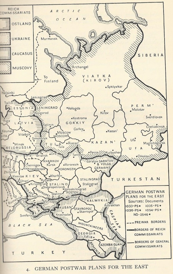
This map might be of possible interest and/or use for Reich Triumphant timelines:

Intriguing; what work is this taken from?This map might be of possible interest and/or use for Reich Triumphant timelines:
Intriguing; what work is this taken from?
That's a good question. As I uploaded this image a few years ago, I can't recall off the top of my head! It's almost certainly either Gerhard Reitlinger's House Built on Sand or Alexander Dallin's German Rule in Russia, 1941-1945 though. I'll look through my copies tomorrow and check.
Interesting. I read a while ago that the plans for German Ostland occupation supposedly included an effective border at the Urals (the "Archangel-Astrakhan" or "A-A" Line, running between those two cities), though a lot of works and maps, including this one, don't show or only hint at it. Any ideas if this was genuine, and if so, just a personal whim of Hitler's, or an actual part of Nazi long-term planning?
As for the A-A line, it looks like that was the end goal for Operation Barbarossa, at least: https://en.wikisource.org/wiki/Führer_Directive_21
Very interesting map! Anyway, does Turkestan become independent or remain part of the rump USSR? On the one hand, the Nazis might use the Central Asian peoples as allies, but on the other hand, even victorious Nazis might strain at the logistics of supporting an independent Central Asia after conquering the European part of the USSR. Plus, with the mass deportations that the Nazis are going to engage in, the rump USSR is going to need some place to put the tens of millions of deportees from Eastern Europe--and I'm unsure if Siberia and the Russian Far East are actually going to be enough to sustain all of those people.This map might be of possible interest and/or use for Reich Triumphant timelines: