• Hi Guest!

    The costs of running this forum are covered by Sea Lion Press. If you'd like to help support the company and the forum, visit patreon.com/sealionpress

Max's election maps and assorted others

I should’ve maybe specified “among whites” - you are of course right, and I didn’t mean to imply that apartheid came out of nowhere. What I meant was that there could be a degree of parliamentary competition before 1948 (or perhaps more accurately before some vague point in the 50s) because it was easier for both the electorate and the political class to maintain illusions as to how real South African democracy was.
Yes, that's fair. White electoral politics was much more competitive before 1948 (I think between 1948 and 1994 the Nats only failed to get more than 50% of the popular vote twice, 1953 and 1989).

And even for whites free political activity became more difficult under the Nats, censorship, a degree of restriction on freedom of association, a number of whites also got banning orders etc. Of course, the restrictions whites had were not even 1% of what black South Africans had to deal with but white South Africans certainly didn't have free and open political activity either.
 
It’s reasonable that this isn’t a part of their history that they’re proud of, but like, there’s plenty of maps around of the German election of 1933.
Part of that, I'm sure, is that the Germans have always been meticulous record-keepers, regardless of the era; it's one of the reasons prosecution of Nazi war criminals was possible in the first place. Press coverage pre-Nazi was also slightly less restricted than National-era SA, I think.
 
Part of that, I'm sure, is that the Germans have always been meticulous record-keepers, regardless of the era;
The Museum of German History in Berlin is the only museum I've ever seen which actually has detailed historical maps of Europe, with a consistent colour scheme, to illustrate each corresponding era. Compare that to the usual blobby mess with an icon of the Colosseum floating somewhere in the Tyrrhenian Sea which is the norm here. (I exaggerate but only slightly).
 
Finding constituency maps for pre-1994 South Africa is, as I understand it, one of the great Holy Grail quests for the mapping and alternate history communities. I've never seen an actual one online anywhere, though I have seen one or two proposals for if modern-day South Africa adopted FPTP/AV or STV with small district magnitudes. If I had to guess, there probably is one lying in an archive or library somewhere in the country itself, but unless I've missed it, it's never been scanned and/or uploaded. And I looked quite a bit back in grad school while trying to work out the precise boundaries of Helen Suzman's constituency (she was the only anti-apartheid MP for many years, but I could never figure out where precisely her seat started and ended).
Going to post a WIP solely to address this. Suzman was first elected in 1953, and as it happens, that's one of the few years we have gazette descriptions for. Houghton isn't actually fully described by those, since a couple of the pre-existing polling districts weren't redrawn to acommodate it and so were only described as "polling district no. XX", but together with the bordering seats I believe I have a rough idea of what the seat looked like at the time. As usual, it's worth noting that some of the boundaries are conjectural, especially along the eastern boundary facing Orange Grove, which I sort of would like to think was less weird than this. (Also Yeoville is probably not done despite being fully drawn in on this, I just haven't gotten around to changing it).

1694723190870.png
 
Going to post a WIP solely to address this. Suzman was first elected in 1953, and as it happens, that's one of the few years we have gazette descriptions for. Houghton isn't actually fully described by those, since a couple of the pre-existing polling districts weren't redrawn to acommodate it and so were only described as "polling district no. XX", but together with the bordering seats I believe I have a rough idea of what the seat looked like at the time. As usual, it's worth noting that some of the boundaries are conjectural, especially along the eastern boundary facing Orange Grove, which I sort of would like to think was less weird than this. (Also Yeoville is probably not done despite being fully drawn in on this, I just haven't gotten around to changing it).

View attachment 73173
Apropos of nothing, I drove through that area twice today, ha ha.
 
Going to post a WIP solely to address this. Suzman was first elected in 1953, and as it happens, that's one of the few years we have gazette descriptions for. Houghton isn't actually fully described by those, since a couple of the pre-existing polling districts weren't redrawn to acommodate it and so were only described as "polling district no. XX", but together with the bordering seats I believe I have a rough idea of what the seat looked like at the time. As usual, it's worth noting that some of the boundaries are conjectural, especially along the eastern boundary facing Orange Grove, which I sort of would like to think was less weird than this. (Also Yeoville is probably not done despite being fully drawn in on this, I just haven't gotten around to changing it).

View attachment 73173
You have no idea how neat it is to finally see this--thanks, Ares!
 
South Africa 2011 (demographics)
Another bit of modern South Africa I banged out while trying to make sense of the old boundaries. As mentioned previously, the census that was supposed to happen in 2021 was delayed by half a year, presumably due to COVID, and so 2011 is still the most recent census we have a full set of data for. I don't think I've ever seen a map of these figures in anything close to my usual style - the ones Wikipedia has are all at a more granular level, and mostly not gradated - so I decided it would be useful to work out what the demographics of each local government area looks like, and here's the result.

The big political divide of post-apartheid South Africa, with the rural east voting heavily for the ANC while the DA does better in the former Cape Colony, is in large part reflective of an ethnic divide between the two halves (geographically speaking, obviously the eastern "half" has far more people) of the country: the Western and Northern Cape, with their centuries of colonial rule and intermingling between colonial and indigenous peoples, is now almost all majority Coloured, while the Eastern Cape, Natal and the former Boer republics, which are all much more arable as well as more recently colonised, retain strong Black majorities for the most part. One interesting aspect of this which the maps on Wikipedia don't do a great job of capturing is that the degree of this differs a great deal from place to place - the Highveld, broadly speaking, has a pretty significant White minority of around 15-20%, while the northeast, much of rural Natal, the eastern and central bits of the Eastern Cape and the areas bordering Botswana are all almost monolithically Black. It's not at all a coincidence that these are in many cases the same areas set aside as "Native reserves" under the 1913 Land Act and later turned into bantustans during the darkest years of apartheid.

The language map paints a slightly different picture - for one, we can see how incredibly diverse Gauteng is, which doesn't really come out on the racial map. Johannesburg's plurality first language is Zulu, which is spoken by 23% of the population. Neither Ekurhuleni (the East Rand) nor Tshwane (Pretoria) has any one language spoken by more than 30% of their residents, and Cape Town isn't far behind with Afrikaans on 35% and both English and Xhosa just under 30%. As for the rest of the Cape, it's pretty homogenously Afrikaans-speaking, that being the language of both the White and Coloured communities in most of that region. The Eastern Cape is, again, the exception, with its large Black population almost entirely Xhosa-speaking. The Xhosa in the Eastern Cape and the Zulu in KZN and southern Mpumalanga form both the biggest and most cohesive language regions in the country - the Afrikaans one, again, being very sparsely populated for the most part - while the former Transvaal Province has an absolutely bewildering variety of languages spoken both in rural and urban areas. One thing that surprised me was that there's nowhere, even in the diverse urban areas, where English is the plurality language, although I believe it may have been in both Cape Town and Johannesburg until relatively recently. Obviously, while generally probably a good thing, the consolidation of local government in urban areas after 1994 does mean a fair bit of nuance gets lost on maps like this, which I suppose is why the Wikipedia ones all go for ward level instead.

za-demo-2011.png
 
What's the primary language for Indian/Asian South Africans? English? I ask because Durban sticks out quite clearly on both maps, and I seem to recall that being the major center for the Indian population in SA.
 
What's the primary language for Indian/Asian South Africans? English? I ask because Durban sticks out quite clearly on both maps, and I seem to recall that being the major center for the Indian population in SA.
Yes - most of them no longer speak the various Indian languages their ancestors spoke, and the vagaries of SA education policy means they've basically all ended up speaking English as their first language. Wikipedia does claim some of the ones living in rural areas speak Afrikaans, but there can't be many of those.
 
One thing that surprised me was that there's nowhere, even in the diverse urban areas, where English is the plurality language, although I believe it may have been in both Cape Town and Johannesburg until relatively recently.
I'm not sure how surprising that actually is- my ignorance might be showing, and if so apologies for that, but I get the impression it's more of a lingua franca for the various linguistic groups than a mother tongue in modern SA. Sort of the linguistic equivalent of the 'second everywhere' effect that sometimes gets talked about with FPTP elections.
 
I'm not sure how surprising that actually is- my ignorance might be showing, and if so apologies for that, but I get the impression it's more of a lingua franca for the various linguistic groups than a mother tongue in modern SA. Sort of the linguistic equivalent of the 'second everywhere' effect that sometimes gets talked about with FPTP elections.
It is the native language of almost 10% of the population - but you’re right in that those 10% are a lot less concentrated in any one area than, say, the Tswana speakers are.
 
It is the native language of almost 10% of the population - but you’re right in that those 10% are a lot less concentrated in any one area than, say, the Tswana speakers are.
Indeed. Also, I had a thought from looking at the big east-west divide on the racial group map- how did white vs non-white population affect constituency population in the apartheid era, if at all? I assumed the seats were drawn based on the electoral rolls of whites only, and obviously the bantustans didn't have constituencies, but you'd think that would make the Cape Province more overrepresented than it seems to be on the 1989 map.
 
Indeed. Also, I had a thought from looking at the big east-west divide on the racial group map- how did white vs non-white population affect constituency population in the apartheid era, if at all? I assumed the seats were drawn based on the electoral rolls of whites only, and obviously the bantustans didn't have constituencies, but you'd think that would make the Cape Province more overrepresented than it seems to be on the 1989 map.
Well, obviously Coloureds also couldn’t vote (at least not for the House of Assembly), and I don’t think the white population was actually higher in the Cape than it was in the other provinces. I can’t find percentages broken down by province for this period, but I know Transvaal had the largest white population in raw numbers as of 1960, and they seem to have outnumbered the Cape by a wider margin than they did in terms of total population.
 
Cape Colony 1898
We're still trying to find reliable maps of the early South African elections, so those will be a while, but before then I do have a prologue of sorts to share. Yesterday I found a link from Wikipedia to a master's dissertation from the University of Cape Town, written in 1980 by Alan John Charrington Smith (I don't know which of those are first and last names, so I'm just typing in all of them in full), which goes into excruciating detail about the last few legislative elections in the Cape Colony before unification, starting in 1898 and ending with the colony's final election in 1908.

Starting in 1898 makes a degree of sense, because while one can definitely say clear political lines of disagreement existed before then, 1898 is really the first election to be fought with a real party system. The Progressives, the Cape's first organised political party, was founded as a political vehicle for diamond magnate-turned-politician Cecil Rhodes, who had first been elected to the House of Assembly in 1880 and became Prime Minister ten years later. Rhodes has become relevant again in recent time owing to protests against his economic legacy in universities across the UK and South Africa, so he should need no further introduction, but to summarise briefly: his policies were staunchly pro-imperialist, both in the sense of supporting continued British rule and continued colonial expansion. Having made his money in the Big Hole of Kimberley, Rhodes was convinced it was his personal destiny and that of the British Empire to secure as much as possible of Africa's mineral wealth for itself, and for that purpose he founded the British South Africa Company to conquer and rule a large chunk of land in south-central Africa that he modestly christened Rhodesia. He was equally convinced that the black population's destiny was to provide cheap and expendable manual labour for Britain's colonial project, and to that end sponsored laws that raised the property qualification for voting (the Franchise and Ballot Act 1892) and imposed strict limits on the amount of land a black person could own while also dissolving the pre-existing communal land tenures held by indigenous villages (the "Glen Grey Act" of 1894). These laws are usually considered some of the first legislative precursors to apartheid, and did much to undermine the supposedly race-blind nature of the Cape electoral franchise.

However, Rhodes' influence did not extend across all of South Africa, and this fact haunted him throughout his political career. In the Witwatersrand, which at the time was part of the independent South African Republic, a huge seam of gold had been discovered in 1886, and this brought a large influx of settlers from the Cape and other British colonies. To Rhodes, this was an intolerable situation: a potentially world-changing amount of precious metals, sitting right outside his borders. Luckily, the strong presence of British workers and mining corporations in the Rand meant that the gold rush didn't necessarily threaten British dominance in the region, and in fact, might present an opportunity to seize control of the SAR and end the Boer self-government experiment once and for all. A plan was hatched whereby Leander Starr Jameson, the chief administrator of Southern Rhodesia, would lead a force of some 600 colonial militiamen into the SAR, where they would join up with an insurrection among the mineworkers in the Rand and seize control of the republic for Britain. Unfortunately, Rhodes and Jameson made no plans to actually bring about this insurrection, and it quickly became apparent that neither the miners nor the government in London had any interest whatsoever in supporting them. The "Jameson Raid" ended up an embarrassing debacle, with the force stopped dead by Boer commandos and its leaders taken prisoner.

There were some brief attempts to paint the Raid as an adventure and Jameson as a dashing colonial hero, but ultimately it was very hard to get past just how stupid it had all been. It had shown the SAR to be far more capable of defending itself than anyone had thought, and Kaiser Wilhelm sent a congratulatory telegram to President Kruger in which he seemed to offer his support if the republic ever needed to defend itself again. While Jameson was away, the Ndebele people launched an uprising of their own which would last eighteen months and claim many thousand lives. And back in Cape Town, not only was Rhodes forced to resign, the debates following the Raid led to the formation of the first-ever real opposition party in the colony.

The Cape was, of course, a very heterogeneous place then as now, and when the Voortrekkers left to establish the SAR and the Orange Free State, quite a lot of Afrikaners stayed behind, and continued to form the majority of the rural white population. Compared to the British settlers who dominated the cities and and the more recently annexed border regions, the Afrikaners were a lot less interested in the British colonial project - which isn't to say that they weren't racist, they just preferred not to take marching orders from London. The Jameson Raid raised particular ire, being directed against their "countrymen" in the SAR, and when Parliament was dissolved in 1898, the Afrikaner Bond's Cape section decided it would go into the election in direct opposition to the Progressives. The Bond was an organisation that existed across what would become South Africa, and was devoted to securing the rights of Afrikaners - that is, white Dutch/Afrikaans-speaking people who considered themselves African rather than European - against British encroachment. It also sometimes advocated for the formation of a unified South African republic outside the British Empire, although this was not a goal actively pursued by its members in the Cape.

Rhodes was succeeded in office by J. Gordon Sprigg, veteran MP for East London, who had first been named Prime Minister in 1878 and now began his third stint in the role. Sprigg was, like Rhodes, an imperialist by inclination, but whereas Rhodes was a phenomenally wealthy mining speculator who stood for naked capitalism above all, Sprigg represented the interests of the Eastern Cape settlers who had first arrived from Britain in 1820 and who, in many ways, formed a totally distinct society from the rest of the colony. These areas had been conquered from the Xhosa over the course of several bloody "frontier wars" that lasted a whole century, starting under Dutch rule in the 1770s and ending with the surrender of the last guerrillas in the Amathole Mountains in 1879. Their inhabitants were still conscious of the military threat from the native population, however, and so they tended to favour a strong imperial connection as a way of defending their settlements. This was also Sprigg's position, and in fact he had presided over the defeat of those last Xhosa holdouts - however, he came to power with support from significant portions of the Bond as well as the Progressives, and his third premiership would be focused on more administrative issues.

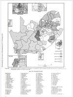
Specifically, Sprigg supported a project to reform the way the House of Assembly was elected to reduce rural overrepresentation, and thus weaken the influence of the Afrikaners, whom he regarded as another threat to British supremacy in the colony. Although his redistribution bill passed second reading, it caused significant tension within his coalition, and Bond-affiliated independent MP William Philip Schreiner ended up successfully pushing a motion of no confidence against Sprigg's government in May 1898. As a result, the lower house was dissolved mere months after the Legislative Council elections, and the elections would be fought on the same wildly unrepresentative boundaries as had existed beforehand. The seats ranged in size from Cape Division, with 8,122 registered voters, to Victoria East with 782 - both two-member seats, as were the majority of constituencies in place. The only exceptions were Cape Town and Kimberley, whose 7,798 and 5,674 voters respectively elected four members each, and the border constituencies of Mafeking, Tembuland and Griqualand East, with 605, 2,110 and 1,333 voters electing one member each. In total, the House counted 79 members, and as mentioned earlier, they were elected under a nominally race-blind franchise, with every adult male citizen of the colony owning at least £75 worth of property eligible both to vote and to stand for election. In practice, however, every single MP elected throughout the House's existence was white.

The 1898 campaign was spirited, with issues ranging from the Jameson Raid and the future of British imperialism in southern Africa to the urban-rural and British-Afrikaner divides (closely related to one another) within the colony itself. The Bond accused the Progressives of being supported by the colonial administration, while the Progressives accused the Bond of taking secret funding from the Boer republics and the Germans. The other big issue were food import duties, which the Bond strongly supported while the Progressives were forced to take a compromise position to avoid upsetting either the urban or rural parts of its base. There was also the issue of Rhodes, who continued to be identified with the Progressive Party even in retirement, bankrolling a large part of their campaign expenses and making sporadic statements about his readiness to return the moment the people called for him. This was questionably realistic, not least because he was in terrible health at this point and would die just a few years later, so the Progressives focused their efforts on defending the Sprigg ministry.

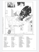
Their success in this would be very limited. The elections were held on different dates over the course of August 1898, and when the returns were completed on the 5th of September, the Bond and their independent allies had won 40 seats - the narrowest possible majority - in the House. Sprigg held on as Prime Minister initially, but in October lost another confidence vote, and Schreiner took office leading a Bond-dominated ministry. He immediately made clear his desire to work towards a peaceful understanding with the Boer republics to settle the issues that had precipitated the Jameson Raid, but this would bring him into conflict with the colony's new Governor, Sir Alfred Milner, whose intentions were entirely different...

val-za-cape-1898.png
 
The seats ranged in size from Cape Division, with 8,122 registered voters, to Victoria East with 782 - both two-member seats, as were the majority of constituencies in place.
Name a better duo than "British colonial legislatures" and "wildly unequal constituencies."

Awesome writeup too, Ares! One question: what's the small (I'm guessing urban/town-based), two-seat constituency in the modern-day Eastern Cape, a bit Northwest of (what was then) Port Elizabeth?
 
Awesome writeup too, Ares! One question: what's the small (I'm guessing urban/town-based), two-seat constituency in the modern-day Eastern Cape, a bit Northwest of (what was then) Port Elizabeth?
That’s Grahamstown, technically the only city other than Cape Town that was represented separately from its district - although of course, Port Elizabeth district had very few rural areas in it. It was the main city in the 1820 settlement area, but I’m pretty sure it was dropping off even by this time.
 
Back
Top