• Hi Guest!

    The costs of running this forum are covered by Sea Lion Press. If you'd like to help support the company and the forum, visit patreon.com/sealionpress

Max's election maps and assorted others

You're right; Straucher was definitely an assimilationist first and foremost. He clashed quite a bit with the Bundistn (Romanian/Galician Bundists, ie the Jewish trade union and socialist movement), as well as the Poale Zion (dissenting socialist Zionists who had lost to integrationists around the turn of the century for control of the various Bund movements) over the issue of assimilation versus exodus. He was an interesting fellow outside of all of this too; his career at the local level helped to elect the first Jewish mayor of any "major" city in the Austrian empire.

This entire era of history in Bukovina and Galica is interesting because it exposes one of the biggest cleavages in Jewish politics: the question of language. Traditionalists wanted to continue the work of the Hebrew-language revival, whereas Bundists across eastern Europe were increasingly in favor of elevating Yiddish to be a pan-Jewish community language. Straucher was in a third, minority grouping as an assimilationist: he wanted Jews to learn German to better integrate into the Empire. When that failed to gain traction, he fell in with the Yiddishists (though they never really embraced him warmly).

As for why he's being categorized as a Zionist, my bet is it's that it's because he was associated with some of Jabotinsky's school of thought (albeit not the Zionist part, so it's still quite curious).
 
Okay, I suppose this is a new thing. The city archives in Stockholm have two key advantages over others: firstly, the municipality is very large and has a fair bit of money to throw around on this sort of thing, and secondly, it handles a significant amount of state documents as well as those of the city itself. This means it has the sort of funding it needs to, for example, digitise and publish a large number of historical documents relating to the city, including the full proceedings of the City Council from 1863 until 2009 (I assume newer ones are also stored in digital form, but they're not in the historical database). Idle hours spent at various archive jobs over the past two years have left me reasonably well-versed in how to get the necessary information to make election maps, and so when I found this database, I was also able to find the various measures relating to the drawing of polling districts. Unfortunately, quite a lot of them only list changes made and don't provide a full list - which is reasonable since the city had more than 200 polling districts for most of its modern history (it currently has 598, including the six non-geographical "Wednesday districts"), but slightly annoying for me. For those measures that actually redrew all of them comprehensively, they usually include a note like "The proposed districts, outlined in schedule A (not printed here)", and after looking at a few notes like that, I eventually gave up trying to draw the 40s-50s districts I'd originally set out to look at.

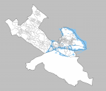
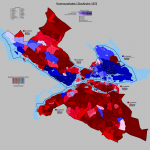
However, I went back into the archives yesterday and discovered that the later ones, or at least the one passed for the 1976 elections, did include a full list of polling districts with boundary descriptions. As such, I present to you the northern half of Stockholm with its 1976 polling districts, and a bit of water (sidenote: Stockholm has too much water) added for context in the inner city. I'm probably not going to draw in all the water inside the outline of the map, but I do plan on getting all the coastlines inside the city limits included. That's work enough.

sthlm-valdistrikt-1976.png

Another note: since the settlements in the Kista region were very new, the districts there (numbered Sp22-29 on the map) were defined in terms of property numbers rather than the standard cadastral addresses used for virtually everything else. As such, I've had to draw on the vague notes about where each district was as well as modern-day district boundaries to figure them out, and so they're very much conjectural in places.
 
Last edited:
Okay, the key probably needs to be bigger, and there's a few bodies of water I still need to add, but bar those, this should be it for 1976. I may make another map showing the results by bloc, as it's kind of hard to tell from this one that this was an election the right-wing parties won.

View attachment 59638
I'm curious; What's important about E10 that means it returned a Left/Communist plurality rather than some of the other, more SAP areas? Cheers.
 
Latvia 1920
Latvia had an election yesterday, and that sent me down a wiki rabbithole that eventually led me to discover that they actually have a very good supply of old election reports from the interwar period scanned and made available through their electoral commission - benefits of having the same constitution and basically the same electoral law as they had back then, I suppose. The reports are in Latvian, a language I do not even remotely speak (so with that in mind, please accept my apologies for the Latvian in the image below - I really tried), but most of the table keys are also in French, a language I can sort of squint my way through. So with that in mind, here's the very first election ever held in an entity calling itself "Latvia", the 1920 Constituent Assembly election.

This election was called pretty much immediately after the armistice between the Latvian national forces and the Red Army in February 1920, and held in April, before there was even a formal peace treaty in place. So the Russian Civil War was very much still raging at this point, even if it wasn't raging within Latvia anymore, and the Bolsheviks, who had some measure of support among the Latvian workers, boycotted the elections. This meant there was effectively only one left-wing force available to vote for - the Social Democratic Workers' Party, organisationally descended from the Latvian Mensheviks, who consequently cleaned up and won nearly 40% of the vote. This wasn't enough for a majority, however, and between the two different Agrarian parties (Latgale had its own one, because they're kind of weird even now and were extremely weird before that part of the country was swamped by Russian migration during the Soviet era), the small bourgeois parties and the various ethnic minorities, the Assembly was essentially centre-right in temperament. The Constitution they wrote, the Satversme (a neologism intended to sound more Latvian than the usual "konstitūcija"), created a parliamentary republic with broad judicial and popular oversight over public power, avoiding most of the social rights that were becoming popular to put in constitutions around this time as well as any notion of abridging the right to private property. A bill of rights was intended to be passed along with the Satversme, but this was voted down by the assembly and not added to the constitution until 1998.

val-lv-1920.png
 
Last edited:
I'm really loving your pre- and interwar maps of Eastern Europe, Ares. Gives a sense of how widespread (and, honestly, ideologically diverse) the Jewish community was in that era (on top of the politics of these countries as a whole!), which is adjacent to a lot of the things I study professionally.
I hope the Yiddish is alright - unlike Latvian, where I don’t understand the language but can figure out the spelling from various sources, for Yiddish I probably would understand a fair amount but can’t read the script and wouldn’t be able to figure out the spelling rules. So the ENB’s Yiddish name is in fact a product of Google Translate.
 
Okay, so, the dynamics in the coalition between the Komeito and the LDP are quite difficult to understand. They neither have the same independence from one another as, say, the Union and the FDP in Germany, nor are they as closely in symbiosis as the Liberals and the Nationals over the Australia.

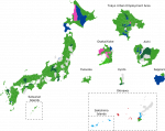
Even though Japan has an electoral system with both single member constituencies in which FPTP rules supreme and multi-member constituencies following D'Hondt party list PR, as part of the perpetual coalition agreement between the Komeito and the LDP, the LDP has decided not to field candidates in a few select single member constituencies to allow the Komeito a free run there as the sole candidate of the right-wing coalition. However, what is remarkable is that these constituencies are not constituencies in which Komeito have much of a natural base themselves (unlike how in Australia, those constituencies in which the Liberals allow the Nationals a clean run on the right, are in rural areas where there is a long-running strong historical base for the Nationals). In fact, consider the following map of the results of the 2017 election for single member constituencies:

2017_FPTP_winners.png

The constituencies in magenta are those represented by Komeito MPs, and as you can see, they tend to congregate around Osaka. Now, I originally thought that this might be because Komeito was for some historical reason very strong there, say, maybe historically, Osaka had been one of the centres for Nichiren Buddhism in Japan, that there was some sort of "Lotus Sutra Belt" in the Kansai region, or what not.

Nope!

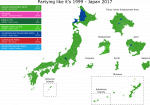
Let's consider what happens if you take the results from the proportional votes and run it as if those were the votes in the FPTP election, much like in @Thande 's famous Partyin' Like It's 1999:

Partying_Japan.png

As can be seen, in a free choice, in every single single-member constituency represented by Komeito, in a "free choice" the voters would prefer to see an LDP man (or woman) in the Diet instead.

This is quite remarkable.

In my follow-up post, I shall give an explanation for why that is, as well as to provide further electoral maps throwing light on the dynamics behind this phenomenon.
 
I hope the Yiddish is alright - unlike Latvian, where I don’t understand the language but can figure out the spelling from various sources, for Yiddish I probably would understand a fair amount but can’t read the script and wouldn’t be able to figure out the spelling rules. So the ENB’s Yiddish name is in fact a product of Google Translate.
Looks pretty good to me, honestly. The nice thing about Yiddish is that once you know what you're looking at, you can often figure out the rest with a cursory knowledge of German. And frankly, Google Translate has gotten much better at handling non-Western/non-Roman alphabet languages in my experience.
 
Latvia 1922
The Constituent Assembly lasted about two years, during which time it managed to pass a number of significant laws beside the Satversme - it set up key cultural institutions for the new republic, established universal public education, reformed marriage and property laws (including a massive land reform intended to increase the number of self-owning farmers, a measure that probably had a bigger impact on Latvian society than the new constitution itself), and reformed the local government system to make town and parish councils directly elected under universal suffrage (under the Russian system, the richest landowners sat on the council by right while the other landowners got to elect representatives and the landless had no say whatsoever).

The centre-right "unity coalition" that had governed Latvia through the independence struggle fell in June 1921 for reasons unknown to me, and was replaced with a new coalition between the agrarian parties, the centrist Workers' Party (now fading into irrelevance everywhere but Latgale) and a breakaway right faction of the LSDSP, who dubbed themselves the Mensheviks (mazinieki, a word that I've also seen translated as "minimalists"). The new government was led by Zigfrīds Anna Meierovics, previously the Foreign Minister under Ulmanis, who was half-Jewish (as the surname hints) but grew up in rural Courland and considered himself Latvian through and through, leading as he did the first Latvian cabinet with no national minorities represented. His government's activities were concerned largely with further statebuilding, including the establishment of the lats as a new national currency and the standardisation of Latvian spelling, replacing the old orthography based on German with a new one that closely represented the language as spoken (hence all the diacritics in modern Latvian writing).

With the Satversme passed and set to go into effect in November 1922, the Assembly dissolved itself and called for a new Saeima, or parliament (the Latvian word is almost certainly related to the Polish sejm, both meaning "meeting" or "assembly", but there was a fun controversy in the 19th century where a Latvian nationalist claimed to have "coined" the term independently and strenuously denied it had any connection whatsoever to any other language), to be elected in early October. The electoral law used for the Constituent Assembly was essentially carried over to this new body, with two slight modifications - firstly, the number of seats up for election decreased from 150 to 100, which was deemed enough for a country the size of Latvia, and secondly, the voter would now be allowed to strike out names from party lists and replace them with candidates from other lists - a form of panachage, basically. The Constituent Assembly spent a lot of time discussing Switzerland as a model for republican government, and no doubt this innovation came from there.

The elections resulted in some losses for both the LSDSP and the agrarians, who did especially badly in Latgale - the Latgalian Farmers' Party was reduced to a single seat, its place as the main voice of rural Latgale taken over by the Christian Farmers' and Catholic Party, which was an overtly Christian democratic organisation modelled on the German Centre Party and directly supported by the Catholic hierarchy. The liberal Democratic Centre also gained slightly, while the minority bloc essentially stayed put (as one might expect). The Mensheviks, who had hoped to seriously compete with the "rump" LSDSP for the working-class vote, suffered what can only be described as a fiasco - with some 6% of the vote and seven seats, they did place third, but it was a poor third, and not enough to save their coalition with the agrarians in government. When the First Saeima met, it elected an LSDSP member to chair it, and President Čakste called on the LSDSP to attempt to form a government. The overall left-right balance hadn't really shifted, however, and they would be hard-pressed to find anyone willing to support them.

val-lv-1922.png
 
Oh yeah, and I updated the 1920 map to show the borders of Latvia as they were then. A number of border parishes, including the ones taken away again in the 40s, were only ceded by Russia with the passage of the final peace treaty in August 1920, so would probably not have participated in the Constituent Assembly election (obviously, I haven't checked even though I easily could). The Lithuanian border, meanwhile, was only settled in 1921, and a few villages were actually moved by the settlement - Palanga, a resort town in the far southwest of Courland, was ceded to Lithuania in order to give them sea access (Klaipeda only became Lithuanian in 1923, after all, in 1921 it was still a League of Nations mandate and that showed no sign of changing anytime soon), and in exchange, ceded three border parishes to Latvia.
 
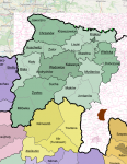
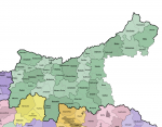
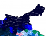
Here it is up to the present-day voivodeship boundary, plus the area around Tarnobrzeg because I needed to figure out what the extreme points were for the base. This is maybe a quarter of Galicia, just to give some idea of how much bigger it was than every other province.

1665931001724.png

The language map is not particularly interesting - aside from the Ruthenian (Lemko) areas in the Carpathians, it's pretty much enturely Polish-speaking. Of course, there was a substantial Jewish minority all throughout Galicia, but they appear to have largely reported themselves as Polish. Tarnow, one of the region's major Jewish cultural nodes, reported well over 95% of the population speaking Polish, and several of the more rural districts only had a handful (as in, literally single figures) of non-Polish-speakers.

Rest assured that it's going to get more interesting as we approach the Polish-Ukrainian border, although as the base I found only covers modern-day Poland, I'm unsure if I'll be able to keep going east and maintain the same level of detail. I might just end up having to go off the maps of interwar (late 1930s) Polish municipalities available on Wikipedia, which I have a feeling should better reflect the pre-war situation than the modern Ukrainian administrative boundaries.

1665930985741.png
 
Last edited:
Back
Top