• Hi Guest!

    The costs of running this forum are covered by Sea Lion Press. If you'd like to help support the company and the forum, visit patreon.com/sealionpress

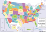
What the US could’ve been

This is the most beautiful map of my country I have ever seen.

I am sitting here in silent, joyful awe as I contemplate how the cartographer skillfully weaved in dozens of events in American history that could have produced this great mosaic that far more perfectly describes the political and cultural groupings that make up the great mosaic of the American people, and trying not to cry.

I give it a 99/100, with the only flaw being that they missed Grant’s attempt to buy what’s now the Dominican Republic.


THIS IS WHAT WE SHOULD HAVE BEEN!!!!!!!!!!!!
 
I Sort of want to know the story behind Forgottonia
It's an area of Illionis that forms 'the Tract', and the name is a play on how the State and Federal Government 'forgot' the region- isolated form the rest of the state by the Illinois river- and failed to meaningfully give it the needed support in transport and infrastructure (a highway connecting Chicago and Kansas City that cut straight through the Tract was defeated in the US Congress about 3 or 4 times, rail service through the area was left a pipe dream, and Carthage College left the Tract. It was used as a way of bringing attention to the issues in the region, with secession just a publicity thing and never meant to be serious.
 
I like how Aroostook is shown separately in Maine - I presume that's just a reference to the Aroostook 'War' and disputed border with Nova Scotia - but it could easily be taken to mean an actual secession, which would be interesting considering that Aroostook is the bit of Maine shown as blank on election maps because there are too few people there to even organise into townships.
 
I like how Aroostook is shown separately in Maine - I presume that's just a reference to the Aroostook 'War' and disputed border with Nova Scotia - but it could easily be taken to mean an actual secession, which would be interesting considering that Aroostook is the bit of Maine shown as blank on election maps because there are too few people there to even organise into townships.

As it turns out, courtesy of Wiki:
Due to remoteness from the rest of Maine and a perceived lack of connection with Maine government, as well as a strong connection with neighboring Canada, politicians of Aroostook County, Maine, have proposed making Aroostook part of New Brunswick or spinning off the county as its own state, probably named Aroostook, since the 1990s. As recently as 2005 the question has been brought up before the state legislature.[16]

Though they would eventually need to have a better flag than this:
308px-Flag_of_Aroostook_County%2C_Maine.svg.png
 
Back
Top