• Hi Guest!

    The costs of running this forum are covered by Sea Lion Press. If you'd like to help support the company and the forum, visit patreon.com/sealionpress

Max's election maps and assorted others

This also makes me realise I don't know how many members there are on Chinese municipality congresses for cities like Beijing or Shanghai. Obviously those are mostly rubberstamps but it'd be interesting to compare. Can't find anything for Beijing, but Shanghai has a wiki article and it has an impressive membership of 868 - though in practice it looks like everything meaningful is done by a standing committee of 57, and (like old American state legislatures) in practice it only sits for a handful of days a year regardless.

Or what about India with its pleasingly RETVRN (to British eyes) Municipal Corporations - Bombay/Mumbai has 227 members (though that's a wider metropolitan area I think) and Calcutta/Kolkata has 144.
 
Precisely 7 uncontested seats apiece. Was there at least a Republican in the only contested one?
Nope, it was just the two Democrats.
NYC council made me have that realisation as well. 51 single-member districts for one of the biggest cities in the world. I was thinking "well this is like the London Assembly and obviously there must be some lower-level councils for the boroughs or something", but nope.
It is worth noting that in LA’s case it’s actually controversial - there was a recent scandal where councillors were caught on tape making racist remarks about an impressive number of different groups while also plotting to gerrymander the districts, and as a result there’s an ongoing process to figure out how to expand the council and make it more representative. It’s still unclear what the result will be, but the likely outcome is somewhere between 25 and 31 seats, so still quite small.
 
Nope, it was just the two Democrats.

It is worth noting that in LA’s case it’s actually controversial - there was a recent scandal where councillors were caught on tape making racist remarks about an impressive number of different groups while also plotting to gerrymander the districts, and as a result there’s an ongoing process to figure out how to expand the council and make it more representative. It’s still unclear what the result will be, but the likely outcome is somewhere between 25 and 31 seats, so still quite small.

We're doing the same in Portland rn (going from four plus the mayor to 12 plus the mayor, amid a bunch of other changes) - I don't think the two efforts are linked, but maybe they will prompt folks in other cities to think about the idea.
 
Great work as always, Ares! Worth considering that as under-representative of the population as LA's city council is, it actually gets worse when you go one level up. Los Angeles County, America's largest by some distance, has a budget larger than the GDP of Iceland (hardly a developing nation) that is decided upon by a whopping five (5) elected Commissioners.

Actually all counties in CA are similar, which is why you occasionally see members of the US House retire to seek a board seat (and in at least one case, a sitting federal Cabinet Secretary), because you go from one of 435 to one of 5 and get a lot more immediate power.
Roybal is historically significant because he was descended from an old New Mexican Hispanic family and is usually considered LA's first Latino councillor (although you do have to add "in modern times" to that, because of course there were a number of Californios elected to the council in its early days).
Since you bring up Roybal, he was one of those folks in politics who ended up with a mini-dynasty. He ended up running for and winning a seat in the House in 1963, which he essentially passed on to his daughter Lucille when he retired 30 years later. She just retired herself in the 2022 midterms, matching her father's longevity.
 
Great work as always, Ares! Worth considering that as under-representative of the population as LA's city council is, it actually gets worse when you go one level up. Los Angeles County, America's largest by some distance, has a budget larger than the GDP of Iceland (hardly a developing nation) that is decided upon by a whopping five (5) elected Commissioners.
I did mention this, yes.
 
Okay, so on reflection I don't think all those elections actually were unopposed. Having looked through all elections up to 1955, ourcampaigns.com shows every single race as unopposed, and the only source they cite is Wikipedia, which simply lists the dates each member was elected. The city clerk's office has a searchable database of elected officials going back very far, which is nice, but also doesn't show actual results. It's possible they may exist in newspaper archives somewhere, but unfortunately, not being a student anymore means I don't have access to many of those.
 
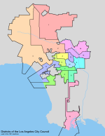
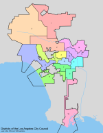
Anyway, with that in mind, here's the district maps for 1951 and 1953.

1951 saw only very minor changes compared to 1949, with boundaries changing around downtown and the Pico-Robertson area, but no districts moving significantly one way or another.

la-dist-1951.png

In 1953, on the other hand, things were rather more dramatic. District 3 was moved across the mountains to become the second district entirely contained inside the San Fernando Valley, while districts 5 and 11 took over its Westside portion. This caused a general westward shift affecting nearly every other district, with 6, 7 and 10 shifting particularly dramatically.

la-dist-1953.png
 
Okay, so on reflection I don't think all those elections actually were unopposed. Having looked through all elections up to 1955, ourcampaigns.com shows every single race as unopposed, and the only source they cite is Wikipedia, which simply lists the dates each member was elected. The city clerk's office has a searchable database of elected officials going back very far, which is nice, but also doesn't show actual results. It's possible they may exist in newspaper archives somewhere, but unfortunately, not being a student anymore means I don't have access to many of those.
Have a look at the California Digital Newspaper Collection, it's digitised, open access and has the LA Daily News back to literally 1860.

[/researchlibrarian]

Edit: yes, just checked the Daily News for 1 June 1949 and the front page confirms that only one City Council race was contested, along with the votes for each candidate.

The election figures are given slightly less front page space than the horse racing results of the same day.
 
Last edited:
Gubernatorial terms in the United States New
Another American one, another quick one.

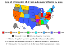
The people who read this thread will probably know that most US states have governors who are elected to four-year terms, either coinciding with presidential terms, coinciding with midterm congressional elections (this one is most common), or in a few cases elected in odd-numbered years. The only exceptions are Vermont and New Hampshire, whose governors serve two-year terms and are up for election alongside all congressional elections.

It may surprise some of you to learn that the latter used to be far more common - and this is one of those constitutional changes that have happened more recently than you'd expect from the US. Until the 1950s, most states in the Upper Midwest, Great Plains, New England, as well as some in the South and Mountain West, elected their governors every two years. This included a few large, politically significant states like Texas and Ohio, but most of the "two-year states" were on the smaller side. Most of them made the switch between about 1950 and 1980, but a couple of stragglers held out - Arkansas changed to four-year terms in 1986, and Rhode Island in 1994.

There was also a significant bloc of states in the Mid-Atlantic region that previously had three-year terms. Most of these had changed to four years by the mid-19th century, but New Jersey held out until 1943 - this is why it still holds all its state-level elections in odd-numbered years. And of course, New England used to pride itself on holding annual elections, but that doesn't show on this map because they all switched to two-year terms before then moving to four-year ones (in some cases). Similarly, New York briefly had three-year terms in the 19th century, but switched back to two years before then going up to four in 1938.

gub-4yr.png
 
Last edited:
Another American one, another quick one.

The people who read this thread will probably know that most US states have governors who are elected to four-year terms, either coinciding with presidential terms, coinciding with midterm congressional elections (this one is most common), or in a few cases elected in odd-numbered years. The only exceptions are Vermont and New Hampshire, whose governors serve two-year terms and are up for election alongside all congressional elections.

It may surprise some of you to learn that the latter used to be far more common - and this is one of those constitutional changes that have happened more recently than you'd expect from the US. Until the 1950s, most states in the Upper Midwest, Great Plains, New England, as well as some in the South and Mountain West, elected their governors every two years. This included a few large, politically significant states like Texas and Ohio, but most of the "two-year states" were on the smaller side. Most of them made the switch between about 1950 and 1980, but a couple of stragglers held out - Arkansas changed to four-year terms in 1986, and Rhode Island in 1994.

There was also a significant bloc of states in the Mid-Atlantic region that previously had three-year terms. Most of these had changed to four years by the mid-19th century, but New Jersey held out until 1943 - this is why it still holds all its state-level elections in odd-numbered years. And of course, New England used to pride itself on holding annual elections, but that doesn't show on this map because they all switched to two-year terms before then moving to four-year ones (in some cases). Similarly, New York briefly had three-year terms in the 19th century, but switched back to two years before then going up to four in 1938.

View attachment 83392
I knew about the New England part but not the number that had had 3-year terms.
 
Washington DC subway plan, 1944 New
Lost a bunch of work to last night's power outage, so the quickies will continue until morale improves.

In the years leading up to WWII, the population of the District of Columbia had nearly doubled. The New Deal programs saw the remit of the federal government expanded hugely, and that brought a lot of new jobs and economic development to a national capital that was still essentially a mid-sized Victorian town. The infrastructure of the city, with low-slung buildings, leafy streets and slow, aging streetcars, was unable to cope, and over the 1940s and 50s, a number of plans were proposed to solve this problem.

In 1941, the District government issued a transportation plan which made only modest recommendations - suggesting stops be removed to speed up travel and particularly busy crossings be grade-separated if necessary. This raised the ire of Congress, which still had significant influence over the District's governance, and William T. Schulte, Democrat from Indiana and chair of the House Subcommittee on District Traffic, immediately set about drawing up a rival plan that would include rapid transit. Even this plan ended up rejecting the idea of a rapid transit subway, partly because DC was still relatively small and partly because it held that a subway line would spur intensive development that would threaten its urban fabric. Schulte lost his seat in the 1942 midterms, and for the next twenty years, transit planning in DC would focus on improvements to the streetcar network.

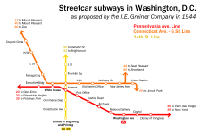
The most ambitious of these plans was drawn up in 1944 by the J.E. Greiner Company, an engineering consultancy contracted by the District government. It called for the construction of three separate streetcar subways, which would total about seven miles in length - the largest such system in the US by some margin. One of these would run along Pennsylvania Avenue, serving both the White House and the Capitol as well as several key federal buildings, while another would run along Connecticut Avenue and G Street and serve the District's commercial core. The third line would run under 14th Street, incorporating the already-existing underground streetcar loop at the Bureau of Engraving and Printing, and stopping at Thomas Circle because of the car tunnel there which made cut-and-cover construction impossible. Most of these stations, aside from the transfer stations and the ones along Pennsylvania Avenue, would be built immediately below ground with no mezzanines - passengers would go directly from street level to the platforms, and to access the platform in the opposite direction would have to go up to surface level and cross the street. This made construction a lot cheaper than bored tunnels, and the entire thing was estimated to cost $56 million (just under a billion in today's money).

However, the plan soon met with opposition. Congress found it too expensive, with the post-war mood shifting decisively away from big government projects, and the public complained that it would require too many rerouted lines and place stations too far apart (insanely, given how they were far closer than in any subsequent proposal). Finally, the privately-owned Capital Transit system was uninterested in operating underground streetcars because they felt they would make the system too inflexible. Government operation was proposed in later plans, but was opposed by both Capital Transit and organised labour, who believed their bargaining position would be worsened if the government took over. As a result of all this, the government's attention shifted to freeways as a solution to DC's traffic problems, and so it would remain until the early 1960s.

dc-subway-1944.png
 
Hello!
How are you?
Can I request something very weird from you?
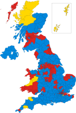
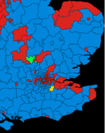
Can you help me to locate the South Bedfordshire constituency during the 1964 Elections, for this map I am doing for my timeline?
1964 UK ELECTORAL MAP.png
 
Sorry to hear about the loss of work Max, that's always incredibly frustrating.
Hello!
How are you?
Can I request something very weird from you?
Can you help me to locate the South Bedfordshire constituency during the 1964 Elections, for this map I am doing for my timeline?
Highlighted in green.

1714745122903.png
 
Back
Top