• Hi Guest!

    The costs of running this forum are covered by Sea Lion Press. If you'd like to help support the company and the forum, visit patreon.com/sealionpress

Max's election maps and assorted others

Some more railway stuff: we've now made it to Bergslagen, where you can see a number of the biggest private railways on display. As ever, freight was the big cash cow here, and the mines meant that railway companies that operated here could stay in the black for much longer than their counterparts in less industrialised regions.

järnväg-1927.png
 
Finland 1945
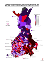
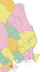
I've been returning to Finland again in "preparation" for their election in April, and updating the historical maps I made a few years ago to fit the current format. As a byproduct of this, it occurred to me that it would be interesting to map the relative voteshares won by the SDP and SKDL in each municipality in the March 1945 general election, since the split happened shortly before (the Communist Party had its organising ban lifted in September 1944 as a provision of the Moscow Armistice, and the SKDL itself was formed in October as an umbrella organisation for the Communists, left-wing splinters off the SDP and various civil society organisations) and the two parties won more or less equal shares of the vote (25.1% for the "rump" SDP and 23.5% for the SKDL). The SKDL didn't derive anything like all of its votes from the SDP - the two parties combined won some 825,000 votes, compared to 515,000 for the SDP in 1939 - but mapping the split still allows us to see which regions tended to favour which side of the Finnish left in an almost 50-50 situation nationally.

val-fi-1945-skdl.png
(There's quite a bit of Finnish missing from this, because it's not a language I actually speak and the terms I need can't be easily taken off other places)

A couple of things are very clear: firstly, and perhaps unsurprisingly, Karelia did not like the SKDL one bit. It's worth noting that residents of the areas ceded to the Soviet Union were spread out across Finland and did not vote in their "home" municipalities, but rather through polling stations set up in the municipalities to which they'd been relocated. In light of this, it shouldn't be a huge surprise that they weren't keen on voting for a party that was more or less officially supported by the country whose army had just driven them from their homes. However, the antipathy towards the new party seems to have been a thing across historical Karelia (constituencies 6, 7 and 10), even the regions that remained Finnish after the war - perhaps being near the Soviet Union was enough to sway them away from communism. In either case, they would largely remain loyal to the SDP throughout the Cold War, through all the slow shifts that changed the balance between the two parties over the decades.

On the other side of the divide, northern Finland was mostly an SKDL bastion, and would also remain so for decades to come. This was especially true of the industrialised areas along the Gulf of Bothnia coast, Raahe, Kemi and the Oulu suburbs becoming huge strongholds for the party - Kemi continues to vote for the Left Alliance on most levels to this day, even after the party lost more than half of its voter base in the 1980s. Helsinki and Turku also mostly sided with the SKDL, and while Helsinki would swing back to the SDP in fairly short order, the presence of a militant shipbuilders' union in Turku ensured that the city would remain strong for the SKDL for a very long time. The old SDP strongholds in Häme and Satakunta were divided between the two sides, with Hämeenlinna and Pori favouring the SDP while smaller towns like Loimaa and Hämeenkyrö sided with the SKDL. The same was true of Vaasa County, where all the towns except Vaasa itself voted SDP while the SKDL had more of a presence in the countryside - of course, rural Ostrobothnia, whether Swedish- or Finnish-speaking, has never exactly been a left-wing region, so this might not actually say much about the overall distribution of support.

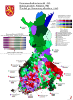
In general, the map above has a crucial flaw in that it makes it impossible to tell where the left as a whole was strong and where it was barely present - for example, Åland's leftist voters almost all voted SKDL, but there were also rarely more than a two-figure number in any municipality. Rather than try to figure out a way to show both scales in a single colour scheme, here's the complete map of the 1945 election so you can see where either of the left-wing parties won and where the others were dominant.

val-fi-1945.png
 
The areal differences in votes between Social Democrats and Communists were already roughly the same in 1920s when Communists were able field candidates through front organizations. These differences were mostly related to how successful the communist takeover of working class institutions in industrial centers had been in the post civil war period eg. very successful in places like Kuopio or Oulu while very unsuccessful in places like Viipuri or Pori. Ironically the difficulties the communist experienced in Eastern Finland might have been partially related to its distance from Sweden as that was the direction from where many of the early communists efforts of were spread.
 
I am far too easy a mark.

kommuner-1917-fin.png

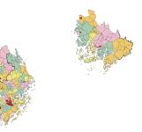
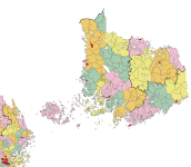
Åland is, bizarrely enough, still missing from this, which is because none of the maps I've found of it have been good enough. I've patched some sections of Finland Proper by using the Maanmittauslaitos basemap, and I may end up doing that for all of Åland, because all the standalone maps I've found have either been far too low on detail or they haven't shown municipal boundaries because they've been focused on showing islands and ferry lines rather than administrative structures.
 
I am far too easy a mark.

View attachment 66091

Åland is, bizarrely enough, still missing from this, which is because none of the maps I've found of it have been good enough. I've patched some sections of Finland Proper by using the Maanmittauslaitos basemap, and I may end up doing that for all of Åland, because all the standalone maps I've found have either been far too low on detail or they haven't shown municipal boundaries because they've been focused on showing islands and ferry lines rather than administrative structures.
Nice one! We love the municipal boundaries north of Turku – that's magnificent border gore.
 
kommuner-1917-meänmaa.png

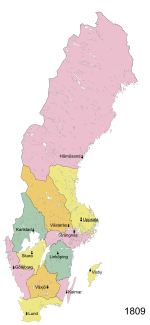
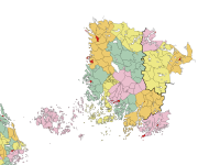
I moved over to the other end, and so here's the undivided Tornedal/Meänmaa region and its municipalities in the alternate 1917. Torneå was and is, in fact, on the western side of the river, or rather on an island in the river with the bulk of it flowing east of the island, so on this map I'm depicting it as if it was on the western shore. The rural municipalities I've generally kept intact, as the river is quite wide and would form a natural border in at least some places, but I've merged a few of them. Karunki and Karl Gustav are a no-brainer, as both are quite small and were a single parish before 1809. This was also true of Nedertorneå/Alatornio and Övertorneå/Ylitornio, but I've decided the former would be populous enough to split in half (the western half would likely get a new name, since the parish church is east of the river - Haparanda/Haaparanta would be an obvious contender even though the city of that name wouldn't exist ITTL) while the latter just looks too damn weird when merged. This is a decision I may come to revisit. Either way, the two annex parishes created by Sweden in the north of the valley are here detached from their mother parishes and joined with the municipalities on the eastern side of the river. Svanstein, whose church village is directly opposite Turtola on the eastern side, joins the municipality of Turtola/Pello (in 1917 it was centred in Turtola, but the administration was moved to Pello in 1949 and the municipality renamed with it - this may or may not happen ITTL), while Muonionalusta quite obviously joins Muonio. This means a total of five "new" municipalities (six if we count Torneå, which replaces Haparanda and thus doesn't really count as an additional municipality) have been added to Norrbotten County, with another 4-6 in Lapland also joining once I draw those.
 
Estonia 1923
Since I already had a basemap (and a much more legibly-scaled one than the Latvian one, at that), this came together pretty quickly.

Estonia and Latvia shared some common denominators in the years immediately following independence - the two biggest parties were a social-democratic one descended from the local Mensheviks (the Estonian Social-Democratic/Socialist (after 1925) Workers' Party (Eesti Sotsiaaldemokraatiline/Sotsialistlik Tööliste Partei, ESTP)) and a right-leaning agrarian movement in which several of the most prominent leaders of the independence movement were involved (the Farmers' Assemblies (Põllumeeste Kogud, PK)). However, Estonia also had a number of other significant parties, most notably the Labour Party (Eesti Tööerakond, ETE), a party of the "non-Marxist left" which consciously modelled itself on the French Radical Party. Its founder, Jüri Vilms, one of the most radical independence activists, disappeared in Finland in 1918 under mysterious circumstances (he's believed to have been captured and executed by the Finnish White Guard's German allies, who did not recognise Estonian independence and saw Vilms as an obstacle to their plans to install a German-dominated government in the Baltic provinces). This did nothing to undermine the party itself, and in the 1919 Constituent Assembly election, they won 30 out of 120 seats, which alongside the 41 won by the ESTP was enough to ensure a working left-wing majority.

Which in turn ensured that the Estonian constitution came out quite different from the Latvian one, being generally a much more radical document. It declared the principle of popular sovereignty inviolable, and gave a large number of rights to the citizens including free education, free access to science and art, wide-ranging cultural autonomy for ethnic minorities, and the right to strike. The Constituent Assembly also passed a wide-ranging land reform law that was intended to break the power of the Baltic German aristocracy and ensure that rural Estonians were able to live off their land and work. In the political sphere, it followed one of the most radical interpretations of "popular sovereignty" in history, instituting a broad-ranging system of popular initiative and referendums (including to change the constitution itself) and structuring the government on an incredibly strict parliamentary basis. Although lip service was paid to Montesquieu's principles, in practice the Riigikogu (national assembly) held nearly absolute power over all other branches of government. There wasn't even a ceremonial presidency - the head of the cabinet appointed by the Riigikogu (styled riigivanem, which literally translates to "state elder" or "elder of the nation", vanem (elder) being the traditional title of a village head or small-town mayor in Estonia) was also the constitutional head of state, and could be removed at the assembly's pleasure.

The first elections to a permanent Riigikogu, for which I unfortunately haven't found any detailed results whatsoever, were held in November 1920, a few months after Estonia signed its peace treaty with Soviet Russia and received a very favourable settlement of its eastern border. These elections saw the two governing parties take huge blows, with the ESTP in particular losing a big share of its voters either to abstention or to front organisations for the banned Communist Party. The latter were especially strong in Tallinn, where the Bolsheviks had had a significant stronghold prior to the independence struggle, and the 1920s would see radically different vote splits on the left depending on whether or not there was a significant Communist front active in any given election (very much like the situation across the water in Finland). Also complicating the picture was the Independent Socialist Workers' Party (Iseseisev Sotsialistlik Tööliste Partei, ISTP), which you can basically think of as an Estonian USPD - their roots were a bit different, coming in part out of the old Estonian branch of the SRs, but they filled the same niche in the party system.

The 1920 elections also saw a good showing for the Farmers' Assemblies, who won over 20% of the vote and nearly beat the Labour Party into first place. Their leader, Konstantin Päts, now became head of state leading a coalition with Labour, the Estonian People's Party (Eesti Rahvaerakond, ERE) and the Christian Democratic Party (Kristilik Demokraatlik Partei, KDP). Päts had been a known figure since the 1890s, editing one of the first Estonian-language newspapers (Teataja, which I believe means something like The Observer or The Gazette) and staking out a position that was at once radical in its demands for self-determination and pragmatic in the ways he went about this. He played a significant role in the independence struggle during 1918 and 1919, including leading the provisional government, while stopping short of being an Estonian Piłsudski - for one thing, his military merits were almost nonexistent, and he would always lean on his political ally General Johan Laidoner, a twenty-year Russian army veteran, to back up his words with force. Päts' most fierce rival through all this was Jaan Tõnisson, the Tartu-based editor of the rival Postimees (The Postman) newspaper, who had a much more academic and cultural approach to politics, criticising Päts both for being too uncompromising towards Russia (Tõnisson served in the First Duma in 1906, while Päts was driven into exile and sentenced to death in absentia for promoting treason against the Russian Empire) and for giving too much of a role to Germans and Orthodox nationalities in what was supposed to be a purely Estonian, Lutheran national project. The ERE was essentially Tõnisson's support organisation, promoting a more conservative brand of nationalism alongside a general centre-right programme, and its support was strongest by far in the Tartu region. Despite their long rivalry, Päts and Tõnisson recognised that they had a mutual interest in preventing further socialist reforms, and this was not the last time they would cooperate in government.

The Labour Party left the coalition in October 1921, but Päts carried on leading a minority government for an entire additional year until his government fell due to a corruption scandal in the newly-established national bank (Päts himself was part-owner and chairman of the Harju Bank, one of Estonia's largest private banks, and was known to reward political allies - I don't know the details of this particular scandal, but it's easy enough to imagine). This paved the way for Labour to return to power under the amazingly-named Juhan Kukk, who included the ERE and the Farmers' Assemblies in his government, and doesn't seem to have distinguished himself - he held the fort until April 1923, at which point the Riigikogu was dissolved.

The electoral system used to elect the Riigikogu were very similar to that of the Latvian Saeima, with 100 seats elected proportionally in local districts according to a simple D'Hondt system. However, where Latvia grouped its districts into five large constituencies, Estonia left almost every county as a constituency unto itself, with the result that they ranged in size from 3 to 21 seats. Tallinn was separated from Harjumaa, and Valgamaa and Petserimaa, which were both small and newly-created to cover areas that had been added to Estonia since 1918, were grouped with the larger Võrumaa for electoral purposes. There were no levelling seats, but there were enough large constituencies that small parties could easily get in even without them - it was just that only voters in the larger counties would get the privilege.

The main story of the 1923 election was the collapse of the Labour Party, whose left-wing credentials were seriously tarnished by three years in government with the likes of Päts and Tõnisson. In their place, the rural left-wing constituency went partially to the new Settlers' Group (Asunikkude Koondis), which would become a major player in Estonian politics as the promises of the 1919 land reform law failed to materialise, and partially to the latest Communist Party front, the Workers' United Front (Töörahva Ühine Väerind, TÜV). The TÜV appear not to have been able to organise in Tallinn, because the result there was deeply weird and turnout quite low (by some sources less than 50%, compared to a national average of 67%). The ISTP began a slow collapse that would see them wiped off the political map by the next election, but nonetheless the 1923 elections presented the most fragmented result in Estonian history. The Farmers' Assemblies finally became the largest party in Estonia, but without actually gaining much in the way of votes, while the situation was complicated slightly by the arrival of a significant (well, four seats) bloc of Russian minority representatives in addition to the pre-existing German bloc.

To further complicate things, there wasn't a clear majority for the right or the left even if either side had been able to unite around a programme for government. The only option left was to return to the 1920 formula, now with the Labour element even further reduced compared to the right-wing parts of the coalition. So in August, Konstantin Päts returned as head of state for what would turn out to be far from the last time.
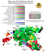
val-ee-1923.png
 
Here's yet another entirely different thing.

After World War II, Helsinki began to grow at a never-before-seen rate, with tens of thousands of refugees from Karelia arriving in the city in addition to hundreds of thousands of internal migrants reacting to rural poverty and the growing mechanisation of agriculture by starting a new life in the capital. This influx of people caused the city to grow well beyond its pre-war boundaries, a problem the city fathers solved by annexing a large swath of land from Helsinki Rural Municipality (as well as all the suburban municipalities created in the 1920s) and planning a huge number of new suburban housing estates there. Which, in turn, created a new problem: how would all those people get to and from the city centre? The tram network, though well-suited to the dense pre-war urban landscape, would hardly be able to convey such a volume of commuters at the necessary speed, and while mass car use was en vogue and featured heavily into the planning for Helsinki's new suburbs, the geography of the city (with the city centre on a peninsula and sea inlets separating it from both the western and eastern suburbs) meant that this soon created a huge amount of traffic jams. It was clear that something needed to be done.

In 1963, the Castrén Committee, which had been appointed by the City Council to study potential solutions to the traffic issue, presented its proposal for a metro system for Helsinki. Rather than propose a full metro like those in Moscow or Berlin, the committee believed a premetro like those then being built in Belgium and West Germany would be more suitable for a city of Helsinki's size (around 450,000 in 1960). They proposed that this system be built gradually over five stages, with the first set to be completed as early as 1969 and the final one by 2000 (the year people always loved to plan towards back then, or so it seems). This would eventually create a system covering the entire urban area, such as it was planned in the 1960s (today it looks quite different, which I'll get to later on).

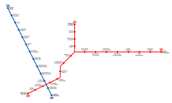
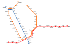
This, then, is a map of the first phase, which was relatively modest in scope, fittingly considering the committee gave the city six years to plan and build it. The line I've designated M1 (the map I'm working from doesn't have line numbers or indeed service patterns of any kind, so I'm improvising a bit) was a surface line running along Mannerheim Road from Erottaja/Skillnaden, the very heart of the city, to Reijola/Grejus in the northwest suburbs, around where the Ruskeasuo tram and bus depot is IOTL. This was presumably meant to be grade-separated, although you would have to build so many grade separations that you might as well just build a cut-and-cover tunnel, so I don't really know what the point of that was (to save on station costs, maybe?). Since it's designated as part of the metro, I've shown it as such here, and we can imagine they'd put it underground in a later phase, or not if the money runs out.

The M2, meanwhile, is essentially the same as the full metro line that eventually opened in 1982 IOTL, at least in alignment. It was quite different technically, however - the tunnel would only be about half as deep as the OTL one (14 metres at the deepest point, compared to 30 IOTL), and the stations were considerably closer together. It also had a branch going north from Sörnäinen/Sörnäs to Kumpula/Gumtäkt, an industrial suburb that was then on the edge of the city, which would eventually allow the metro to reach the new northeastern suburbs.

helsinki-metro-v1.png

Bafflingly, as you can tell from the map, there was no central interchange station planned for these two lines - the stations in the city centre simply follow the existing tram stops. Future lines added to this will have proper interchanges, but for some reason the first two ones to be constructed would not.
 
Last edited:
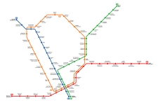
The second phase, slated for completion by 1975, would add three new branches: the M2 would be extended west to Lauttasaari/Drumsö (which it only reached in 2017 IOTL) and the Kumpula branch north to Suursuo/Storkärr, and a new line would be built mostly underground parallelling the M1 on the west and continuing north to Pohjois-Haaga/Norra Haga. This latter line contains the only piece of infrastructure built for this metro: when Finland's first modern shopping centre was built in Munkkivuori/Munkshöjden in 1959, the excavations were done for a metro station to be built underneath it. The cavern sits empty now, but the shopping centre has expanded into the mezzanine, where the intended ticket hall is taken up by an Alko off-licence.

As before, it's unclear how these would actually be served, but I've drawn a new line M3 that takes over the Suursuo branch of the M2, then shares its central tunnel before turning north (I don't know if such a turn was planned, the map shows the two lines intersecting in the final buildout) to serve the new tunnel through Töölö and Meilahti and terminate at Pohjois-Haaga. This creates almost a full loop, which will be completed in the third phase but somehow not quite in the second.

helsinki-metro-v2.png
 
Last edited:
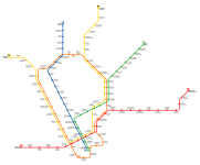
In the third phase, slated for completion in 1980, the M3 circle would be completed, while the M1 would be extended one stop north to Pajamäki/Smedjebacka and the M2 two stops west to Karhusaari/Björnholm, a minor extension on the map but one that takes it the rest of the way across the bay into Espoo. Most notably, it would also add an entirely new branch to Malmi/Malm, an area that remains unserved by the Helsinki Metro to this day, and a new underground line connecting Hesperia to Hämeentulli/Tavasttullen on an alignment essentially following Sturenkatu/Sturegatan. I've chosen to interpret these as forming a single new line, numbered M4, which shares the M1's alignment down to Erottaja/Skillnaden. If I had to guess one point in time when the Mannerheimintie rapid tramway would be put underground, I would place it here, at least up to Hesperia.

helsinki-metro-v3.png
 
Phase four of five was slated for completion by 1990, and here's where we can tell the intervals between the phases are getting longer. In addition to a new tunnel through the city centre running south of the existing one, which I've given to the M3 loop line as its southern section, it called for two new branches off the loop to be built in the north, one short one to Kaarela/Kårböle (the Swedish name of this suburb should not be confused with the village of the same name in Hälsingland, which is probably most famous for the gigantic forest fire there in 2018) and a significantly longer one to the Helsinge church village, which I've truncated a bit to avoid having to extend the map too much - the distance from there to Suursuo was actually about the same as that from Suursuo to the city centre. This phase also included the southern half of yet another new line through the Kallio area, with one station at Linjat/Linjerna, and minor extensions to the Pajamäki branch and the eastern M2. Weirdly, the latter aligns pretty much exactly with OTL - the one metro line we got, which parallels "my" M2 pretty closely, got extended from Itäkeskus/Östra centrum (pretty much the same as the Puotila/Botby gård station on here) to Mellunmäki/Mellungsbacka along more or less the exact alignment proposed by the committee, and this extension opened in 1989.

These extensions, especially the two new branches, create a need for line reorganisation, and after looking very hard at the line interchanges on the map from Wikipedia, I've concluded the M1 should stop serving the Pajamäki branch and instead take over the Kaarela one, which does mean Korppanmäki won't get served as often anymore. Probably not a huge issue, especially seeing as how the new M5, which takes over the Pajamäki branch, stops just down the road in Munkkivuori and continues around the loop (diverting to follow the M3's old alignment from Kamppi to Hakaniemi and then the new tunnel past Linjat) to end up at the church village. At this point, one of the major weaknesses of this plan is beginning to rear its head - there's simply no way to make these branches work without a lot of interlining, which will in turn create uneven schedules and serious risk of disruption. This will likely get even worse in the final phase, which I'm not even going to attempt to map tonight.

helsinki-metro-v4.png
 
Last edited:
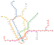
And here's the final buildout, slated for completion by the year 2000. This adds an extension of the Kaarela/Kårböle branch to Vantaa/Vanda (worth noting that the municipality that now has that name was still called Helsinge in 1963, so the Vantaa name refers to the specific area around the Vantaa River) and of the M2 west to Tapiola/Hagalund, putting it well into the Espoo suburbs. Unlike the OTL Länsimetro extension, no plans were made to continue further west, and it's unclear if plans at the time foresaw the kind of suburban expansion that was built by this point IOTL. The remainder of the line through west Kallio and Vallila would also be completed, running largely at grade past four new stations while notably avoiding Pasila/Böle, which on the one hand has pretty much always been intended as a secondary city centre, but on the other hand already had extremely good transport links via the railway station, so it's quite possible that the committee felt these were sufficient.

Most troublesome for me, however, were the two new branches it called for along the eastern M2, one to Vuosaari/Nordsjö (which was built IOTL with all but its outermost station and opened in 1998, so again, strangely accurate) and one across Laajasalo/Degerö and ending at Santahamina/Sandhamn, which is currently owned by the Finnish military and off-limits to the public, but apparently intended to be built on in these plans. Although it's quite hard to figure out, because the map just shows the line continuing to there with no stations beyond Laajasalo.

If I were to draw all three of these as separate lines, I'd have to redo the entire city centre, so I've decided to keep the M2 as a line with two eastern branches, just like the OTL metro line. The Santahamina branch, however, I drew as a new line M6 terminating at Lauttasaari.

helsinki-metro-v5.png
 
Back
Top