• Hi Guest!

    The costs of running this forum are covered by Sea Lion Press. If you'd like to help support the company and the forum, visit patreon.com/sealionpress

Max's election maps and assorted others

While waiting to have your brain destroyed, you can enjoy contemporary maps of the 1907 and 1911 elections here (the only ones I've found that aren't on an absolutely terrible Czech regional library hosting service, instead being on a reasonably good Czech national library hosting service). Along with some very interesting statistics for those who can understand German - you can really tell how Lower Austria was basically the only non-backwater part of the empire they didn't lose in 1919.
 
While waiting to have your brain destroyed, you can enjoy contemporary maps of the 1907 and 1911 elections here (the only ones I've found that aren't on an absolutely terrible Czech regional library hosting service, instead being on a reasonably good Czech national library hosting service). Along with some very interesting statistics for those who can understand German - you can really tell how Lower Austria was basically the only non-backwater part of the empire they didn't lose in 1919.

The French National Library's Gallica system also has the map, at least for 1907.
 
Salzburg and Upper Austria are now both done, which means we're able to put everything together into a single map.

reichsrat.png

Despite having done Prague, I don't think Bohemia and Moravia will be coming in anytime soon, as they were... weird. Instead I'll probably try to finish Kärnten and those parts of the Steiermark that are still within Austria, the Slovenian parts will probably take a while as I haven't got any old municipal maps for most of present-day Slovenia.
 
Genuinely trying to work out what the point of having rural constituencies is when you then separate out every single town from them.
I would assume it's to make sure that the voters in those rural constituencies can all be safely manipulated by their priests informed of their duty as God-fearing patriotic subjects of the Emperor and King from the pulpit before going out to vote.
 
Presidents of the German Reich (1919-present)

1919-1926: Friedrich Ebert (SPD)
1919: def. Arthur Graf von Posadowsky-Wehner (DNVP) (indirect election)
1926-1933: Karl Jarres (DVP)
1926: Friedrich Ebert (SPD), Karl Jarres (DVP), Wilhelm Marx (Z), Ernst Thälmann (KPD), Willy Hellpach (DDP)
1926 runoff: def. Friedrich Ebert (SPD), Ernst Thälmann (KPD)

1933-1947: Carl Friedrich Goerdeler (DNVP)
1933: Otto Braun (SPD), Carl Friedrich Goerdeler (DNVP), Adolf Hitler (NSDAP-HB), Ernst Thälmann (KPD)
1933 runoff: def. Otto Braun (SPD), Ernst Thälmann (KPD)
1940: Carl Friedrich Goerdeler (DNVP), Adam Stegerwald (Z), Hans Vogel (SPD), Ernst Thälmann (KPD)
1940 runoff: def. Adam Stegerwald (Z), Ernst Thälmann (KPD)

1947-1954: Adam Stegerwald (Z)
1947: Adam Stegerwald (Z), Ludwig Beck (DNVP), Carl Severing (SPD), Kurt Schuschnigg (ÖVB), Ernst Thälmann (KPD)
1947 runoff: def. Ludwig Beck (DNVP)

1954-1961: Kurt Schumacher (SPD)


Chancellors of the German Reich (1924-present)

1928-1930: Hermann Müller (SPD) leading Grand Coalition (SPD-Z-DVP-DDP-BVP)
1928: SPD 29.8%, Z/BVP 15,1%, DNVP 14.3%, KPD 10,6%, DVP 8.7%, DDP 4.8%, WP 4.5%, peasants' parties 3.2%, others (including NSDAP-HB) 9.0%
1930-1932: Julius Curtius (DVP) leading Bürgerblock minority (Z-DVP-DDP-BVP)
1932-1933: Johannes Bell (Z) leading Bürgerblock minority (Z-DVP-DDP-BVP)
1932: SPD 24.4%, DNVP 15.0%, Z/BVP 14.8%, KPD 13.6%, NSDAP-HB 9.3%, DVP 6.1%, DLV 4.8%, WP 3.6%, DDP 3.3%, others 5.3%
1933-1936: Wilhelm Groener (independent) leading Bürgerblock (DNVP-Z-DVP-DDP-BVP)
1936-1937: Otto Braun (SPD) leading Grand Coalition (SPD-Z-DDP-DLV)
1936:
1937-1938: Lutz Graf Schwerin von Krosigk (independent) leading nonpartisan caretaker government
1938-1943:
1938:
1942:

1943-1947:
1946:

1954-1956: Julius Leber (SPD)
 
I would assume it's to make sure that the voters in those rural constituencies can all be safely manipulated by their priests informed of their duty as God-fearing patriotic subjects of the Emperor and King from the pulpit before going out to vote.
In some cases it may have been to ensure ethnic representation, especially in places like Bohemia and Moravia, where the countryside had a diffeeent ethnic composition from their towns.
 
In some cases it may have been to ensure ethnic representation, especially in places like Bohemia and Moravia, where the countryside had a diffeeent ethnic composition from their towns.
Oh yeah, but that’s not really the case in any of the regions we’ve done. It is, however, the case that the towns were generally more politically liberal (pan-German) than the countryside, so I think it does still represent a form of packing and cracking.
 
Oh yeah, but that’s not really the case in any of the regions we’ve done. It is, however, the case that the towns were generally more politically liberal (pan-German) than the countryside, so I think it does still represent a form of packing and cracking.

I also think it was a certain philosophical conception, as the same set up occurred in all landtags as well. Or just legacy/inertia from the rural and urban curias and so on. But also convenient.
 
Oh yeah, but that’s not really the case in any of the regions we’ve done. It is, however, the case that the towns were generally more politically liberal (pan-German) than the countryside, so I think it does still represent a form of packing and cracking.
Isn't Tyrol at the time home to a substantial Italian minority?
 
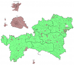
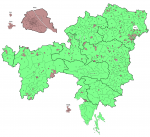
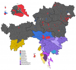
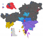
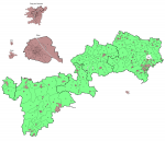
And here it is: all the crown lands wholly or partially within Austria's modern-day borders, with constituencies according to the 1907 electoral order. Worth noting right off the bat that the towns in the lower Steiermark aren't actually depicted in their correct boundaries, as Slovenia (unlike Austria or the Czech Republic) has not preserved the old Austrian system of cadastral districts corresponding to abolished municipalities, which in turn means boundaries of such municipalities are a lot harder to come by. Still.

reichsrat.png

As you can see, Kärnten did things a bit differently from the other states - as we're going to see, all the former Illyrian Provinces tended to group cities and rural areas together. The only real explanation for this I have is ethnic gerrymandering, the conditions of which change from region to region. So for instance, the Steiermark, which had a divide between heavily-German towns and a mixed German/Slovene ("Wendish", in official parlance) countryside that got more and more Slovene the further south you went, which meant there was a clear advantage to grouping the towns together all the way through. Kärnten, however, had a much more diffuse Slovene population, which was concentrated in the southeast corner of the state but spread a lot further out than it does today - towns like Hermagor and Villach had strong Slovene presences, and the local authorities sought to dilute these by the time-honoured practice of packing and cracking. District 3, which had the largest electorate in the state by some way (ten and a half thousand voters compared to an average of about seven and a half in the other rural districts and under five thousand in Klagenfurt), was nicknamed the "Slovenian District" for its almost monolithic Slovene population, while the rest of the Slovene region was split between no less than six predominantly German-speaking districts. This meant that only one Slovene member would be elected both in 1907 and 1911.

Interestingly, a committee of local Slovenes produced their own rival boundary proposal, which looks and feels disturbingly like a modern American redistricting debate. The more things change, the more they stay the same.

val-at-1907.png

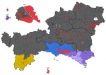
Looking at the results for 1907, we can see a few patterns - the Christian Socials (grey) were strong in rural districts pretty much throughout, with the exception of Kärnten, which as we've discussed didn't really have any purely rural districts. The only district in the state to vote CS was the Lavanttal, which was both monolithically German and somewhat isolated from the rest of the state. In general, the DVP and allies (blue - one day I may try to separate out the different pan-German parties, but today is not that day) did well among two categories: market towns with large middle-class voting blocs, which accounts for the towns in the Austrias and Salzburg, and Germans in regions with mixed-ethnicity populations, which accounts for Kärnten and the urban districts in the Steiermark (and, to some extent, South Tyrol). The Social Democrats (red), basically the only multi-ethnic party in the Empire (although its German, Czech, Italian, Polish and Ruthenian sections were all somewhat autonomous from each other), did much less well than hoped, placing a distant second to the CS in the German districts and falling behind in seats in the Czech districts even as they won the popular vote there. Still, they were able to do well in some of the suburbs of Vienna (as discussed previously) as well as towns in industrial regions like the Obersteier and the Industrieviertel. The Italians (yellow) and Slovenes (purple - for both nationalities, darker shades mean conservatives and lighter shades mean liberals), meanwhile, won more or less the seats they were expected to win, although the Italian Social Democrats had promising results in Trent and Trieste, winning majorities in both cities.

val-at-1911.png

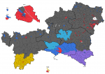
Four years passed, and I think it's fair to say tensions hardened. The dawn of free elections in Austria had not created a parliamentary democracy - instead, the chamber was subject to constant shouting matches and more than occasional fistfights between deputies. According to legend, some of the Viennese made a spectator sport of going down to the Parliament Building and watching the politicians fight. In this climate, the only thing that really mattered was how loudly a candidate could make his voice heard, and inevitably, the ones who shouted loudest were the nationalists. The Christian Socials and Social Democrats both took losses, although the latter were buoyed by their success in Vienna with Lueger's machine having collapsed, and the pan-German bloc made sweeping gains. Notably, two rural districts in Kärnten and the Obersteier were won by "German Agrarians" (aqua), which would become the Landbund after the war - at least to some extent, rural German nationalists were a new concept in the core Austrian lands. Although, as we'll see when we cross into Bohemia and Moravia, that certainly wasn't true everywhere.
 
Stellar work as always, Ares! Pardon me if I missed it somehow, but what's the party of the green seat in the middle of Vienna (Wien-5)?
Oh yes, forgot about that one. That’s Julius Ofner, a left-liberal who was kind of vaguely associated with the pan-German bloc (like all Austrian liberals), but independent enough from it to be considered a separate thing by every source I’ve seen. I showed him as an independent on the Vienna maps, and to be honest I probably ought to do that on these too.
 
Okay, I've now put a key in, in addition to finishing the Slovene lands and the Littoral.

reichsrat.png
val-at-1907.png
val-at-1911.png

The only thing of note I have to say about the now-added provinces is some of those constituency sizes were, as the kids say, wack. The average electorate continued to be around 10,000, but Krain 12, set up to represent the German language island around Gottschee (now Kočevje), had only 3,700, while Trieste 5 (the suburban seat) reached 45,000. So there's more than a 10:1 ratio within this region alone. Eat your heart out, Vienna.
 
Last edited:
EDIT: Max, the other two attachments (48174 and 48175) don't seem to work, at least for me.

Just wait until you get to Galicia, because it was fairly poor and this contributed less to tax revenues, it got 39 seats fewer than it would have been allocated on the basis of population. More visually:


Captura de pantalla 2022-01-03 a las 16.02.46.png
 
Last edited:
Punjab 1937/1945
EDIT: Max, the other two attachments (48174 and 48175) don't seem to work, at least for me.
Hopefully they should work now - my Internet's been a bit up and down today, so it's possible something went wrong with the upload the first time around.

Anyway, I mentioned a few posts ago that Austria reminded me of British India, and that in turn reminded me that Wikipedia actually has full results (or at least full lists of members elected) for the Punjab elections of both 1937 and 1946. So here they are.
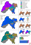
val-in-1937-punjab.png

The Government of India Act 1935 made the Indian provinces fully self-governing (theoretically) for the first time. Until that point, while the provinces had had elected assemblies, those assemblies and the governments they appointed were subject to the "diarchy" system, where appointed colonial bureaucrats kept sole jurisdiction over matters such as policing and military affairs, and could veto the provincial budget. With the 1935 Act, however, the assemblies were to receive full home rule, and the idea was that this would eventually be extended to the central government, creating a "Federation of India" as a self-governing federal state within the British Empire. Kind of like Australia, except much bigger. Obviously that never happened though.

The tradition in India (and several other British colonies) was for the different religious and social communities to elect representatives on separate voter rolls, and this was carried over into the 1935 Act, which set up separate rolls for such key minority groups as Muslims, Sikhs, Christians, Europeans, Anglo-Indians (i.e. biracial people, usually descended from British officials who married Indian women) and, er, women. There were also seats set aside to represent major landowners, business owners, trade unions and universities, in addition to which the Punjab had a special landowner seat for the tumandars (chieftains) of the Baloch tribes along its western borders. With only ten (!) registered voters in 1937, this was by far the smallest constituency in the province.

The "general" roll, which included everyone who didn't qualify for any of the other rolls, was in practice mostly Hindu, although Jains, Buddhists and Adivasi (those who could vote) were also on the general roll. When drafting the Act, the British Government had originally proposed a special roll for Scheduled Castes (i.e. the lowermost castes, mostly but not entirely synonymous with Dalits), but this was fiercely opposed by leading Dalit advocates like B. R. Ambedkar, who was able to unite the Dalit movement and the INC in opposition to this. A compromise was reached whereby certain general-roll seats would be reserved for SC candidates, who would however still be elected by the entire general-roll electorate. To make sure that areas with reserved seats didn't lose out on their non-SC representation, these were all elected in two-member constituencies. On the map, the seat with the asterisk above it is the reserved one, and the constituency is coloured by the party of its non-reserved representative.

To turn to the actual party landscape, it was pretty fragmented. Most provinces had some sort of established political parties from the diarchy period, and those mostly tried to stand for election to the new assemblies, with varying success. In the Punjab, the dominant established force was the Unionist Party, so named not because of its pro-British position but because it sought to unify leading members of all three major religious communities. In practice, its main strength was among rural Muslims, who (just like rural people in most underdeveloped regions, then and now) voted largely based on the clientele networks led by their local imams and landowners. Their leader, Sikander Hayat Khan, was himself one of the most prominent Muslim landowners in the province, and he sat in the assembly for the North Punjab (Rawalpindi-based) landowners' constituency. He was, however, by no means a hardline traditionalist, and his government spent much of its time trying to alleviate the agricultural crisis by measures up to and including land reform. However, he refused to support the INC's plans to use the assemblies as a vehicle to agitate for independence, and when the INC-led ministries in other provinces resigned in protest against the Viceroy unilaterally declaring war on Germany in 1939, Sikander's ministry stayed in power.

The general roll in 1937 was split between the Unionists, the INC and the Hindu Election Board (of which I know absolutely nothing), while the Sikh roll was somewhat more dramatic than expected - the Shiromani Akali Dal had always been the dominant party among the Sikh community (and to some extent still is to this day), but in 1935 it split in half, with (I think) moderate elements walking out to form the Khalsa National Party. The KNP and the HEB, the two parties I know the absolute least about, joined the governing coalition alongside the Unionists even though the latter had a majority by themselves, and the INC and the Akali Dal became the main opposition parties.
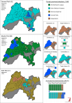
val-in-1946-punjab.png

As mentioned, Sikandar's government stayed on into the war, but the man himself would not last through the end of it. In 1942, he suffered a freak heart attack and died, just fifty years old. Without their leader, the Unionists began to flag, caught between the increased demands for independence led by the INC and the rising communal consciousness of the Punjabi Muslim majority. Although he had signed the Lahore Declaration of 1940, calling for Muslim autonomy, Sikander always insisted that he was opposed to partition and the Pakistan movement, and the party largely carried on this stance after his death. This caused most of the Muslim population to desert the Unionists for the All-India Muslim League, which was quickly transforming into the party of Indian Muslims. The Hindus, tired of war and privation, flocked to the INC, while the reunified Akali Dal was once again dominant among the Sikhs.

The January 1946 provincial elections were held very much with the expectation that India was on the cusp of independence, and the campaign focused almost entirely on what form that independence should take. The Muslim League were able to use the collapse of the Unionist machine and the rising popularity of the Pakistan movement to secure the vast majority of Muslim-roll seats, although the few Unionist holdouts coupled with a complete lack of support outside the Muslim roll (predictably) meant that they were unable to secure anywhere close to a majority overall. Instead, the INC, Akali Dal and Unionists - the anti-partition parties, broadly speaking - formed a coalition, in which the Unionists kept the premiership despite being the smallest of the three parties.

Notably, the new government had support from only a handful of Muslim seats, and none of the parties involved claimed to represent the Punjab's religious majority. This allowed the Muslim League to claim it was illegitimate, and to launch a campaign of massive resistance aimed at toppling the government from without. The province was wracked by strikes and communal violence throughout 1946, and in March 1947, the coalition government was dismissed and the Punjab came under governor's rule. The Akali Dal launched its own resistance campaign in response, leading to another bloody round of communal riots, and in June, the Viceroy Lord Mountbatten announced that partition would be going ahead on 15 August pending the approval of the provincial assemblies concerned. The INC, deeply reluctantly, endorsed the partition plan hoping for an end to the violence, but the way the British executed the plan was generally far less concerned with the lives of those involved than it was with getting the British out as quickly and cleanly as possible. On the day of partition, millions of families found themselves displaced, and with no other viable option, they made for the new international border hoping to reach safety in their community's designated homeland. This caused particular confusion in the religiously-mixed Punjab, where the border was going to leave many thousands on the "wrong" side of the border no matter how it was drawn. The mass migrations caused chaos and sparked yet another round of communal violence, this time killing hundreds of thousands of people (as you might expect, it's very hard to reach a conclusive death toll).

15 August 1947 was the death of the Punjab as a unified concept. The provincial assembly, having voted to approve partition as per the wishes of the INC and Muslim League nationally, was dissolved in July, and its members reorganised themselves into separate West and East Punjab assemblies. The former kept the old assembly buildings in Lahore, while the latter commissioned no less a figure than Le Corbusier to design a new capital city for a new Punjab State, a city that would showcase India's ambition to join the ranks of modern, free nations. Not long after this new city - Chandigarh - was completed, the state split once again.
 
Max, are you planning on shading the victory margins, etc for the districts in the Reichsrat's maps of 1907 and 1911?
 
Back
Top