• Hi Guest!

    The costs of running this forum are covered by Sea Lion Press. If you'd like to help support the company and the forum, visit patreon.com/sealionpress

Map Commons

OHC

deep green blue collar rainbow
Location
Little Beirut
Pronouns
they/she
I'm not sure my personal output of maps is prodigious enough to warrant a whole dedicated thread, and I'm sure I'm not the only one.

So here's a map playground for all!
 
I've been on hiatus from election maps for a while but I decided to get back into them with a survey of Oregon gubernatorial races. Here's a WIP of all the results from 1966 (Tom McCall's first election) to 2016 - with the exception of 1978, since the county results are missing from OurCampaigns and I'll have to come back to it.

Thanks are due to @Thande , whose 2016 primary maps I took the base from.

Du5Jf5K.png


1966: Tom McCall (R) 55.26%, Bob Straub (D) 44.67%
1970: Tom McCall (R) 55.52%, Bob Straub (D) 44.10%
1974: Bob Straub (D) 57.73%, Vic Atiyeh (R) 42.14%
1978: Vic Atiyeh (R) 54.9%, Bob Straub (D) 45.1%
1982: Vic Atiyeh (R) 61.41%, Ted Kulongoski (D) 35.92%
1986: Neil Goldschmidt (D) 51.85%, Norma Paulus (R) 47.85%
1990: Barbara Roberts (D) 45.72%, Dave Frohnmayer (R) 39.96%, Al Mobley (Independent) 12.95%
1994: John Kitzhaber (D) 50.93%, Denny Smith (R) 42.4%
1998: John Kitzhaber (D) 64.42%, Bill Sizemore (R) 30.01%
2002: Ted Kulongoski (D) 49.03%, Kevin Mannix (R) 46.16%, Tom Cox (Libertarian) 4.58%
2006: Ted Kulongoski (D) 50.73%, Ron Saxton (R) 42.75%
2010: John Kitzhaber (D) 49.3%, Chris Dudley (R) 47.77%
2014: John Kitzhaber (D) 49.89%, Dennis Richardson (R) 44.13%
2016 (special): Kate Brown (D) 50.62%, Bud Pierce (R) 43.45%

More coming soon!
 
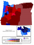
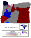
Oregon state legislative elections, 2018. The Democrats gained three seats in the House and one in the Senate, giving them a supermajority in both chambers.

We can see both national and local trends here. Two of the Democratic House pickups were in Portland's more distant suburbs, which could be down to either the "Panera Democrat" (ugh) surge in suburbia nationwide or to poorer Portlanders being pushed out into the burbs by the housing crisis. Or both. Incumbents Julie Parrish and Rich Vial were fairly moderate Republicans and decent fits for the districts; both voted for a law banning domestic abusers from owning guns and were endorsed by the yuppie's organ, the Willamette Week. But trends is trends.

The third Republican loss in the House was in District 52, centered on Hood River, a small but fast-growing city in the Columbia River Gorge, but also including some of Portland's eastern exurbia, separated by a large portion of the Mount Hood National Forest. Social worker Anna Williams defeated ex-cop Jeff Helfrich, who'd been appointed to the seat after the incumbent retired, by a slim margin district-wide but a large one in Hood River itself.

Hood River is an interesting place. It was a logging community, like a lot of places in the rural PNW, but escaped the crushing depression that hit most of the timber belt in the 80s and 90s because of a couple quirks of climate: it's a really good place to grow fruit, and it's on the best windsurfing spot on the Columbia. It's now both a farm town and a tourist hub, and home to big names in West Coast beer. (Double Mountain, pFriem, and Logsdon are worth picking up if you get the chance - Full Sail not so much, although they are of historical interest as one of the country's first big independent breweries.) All this tourist spiel is to say that one trend we might be seeing in these election results is Democratic strength in the state's smaller, regional cities. Democrats came closer than usual in Republican districts in Salem and won back the Senate seat centered on Ashland and Medford that they'd lost in a 2016 special election. They nearly took Hood River's senate seat, too. These cities are growing quickly too, if not quite as fast as Portland is.

(Bend - the dot in the middle of the starfish, in the center of the state - would seem to complicate the picture, but the Democratic nominee there was disowned by the state party and most donors for sexual harassment, so there's a reason it bucks the trend.)

This is just me spitballing, I'll have to take a look at the data to see if it's a plausible theory and the historical results to see if it's anything new, but it would be a good sign for a slightly more diversified Democratic Party in the state.

2018 - State House election.png

2018 - State Senate election.png
 
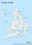
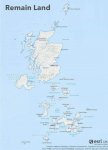
These aren't mine but I thought them interesting enough to post.

View attachment 6358View attachment 6359
The top one is weird because the Leave chunk of NI looks startlingly like a miniature map of Leave GB. (Well, the top half of it - you can see the Wash and East Anglia...)

It's like one of my election maps with the miniature nationwide inset. That's...strange.
 
Oregon state legislative elections, 2018. The Democrats gained three seats in the House and one in the Senate, giving them a supermajority in both chambers.

We can see both national and local trends here. Two of the Democratic House pickups were in Portland's more distant suburbs, which could be down to either the "Panera Democrat" (ugh) surge in suburbia nationwide or to poorer Portlanders being pushed out into the burbs by the housing crisis. Or both. Incumbents Julie Parrish and Rich Vial were fairly moderate Republicans and decent fits for the districts; both voted for a law banning domestic abusers from owning guns and were endorsed by the yuppie's organ, the Willamette Week. But trends is trends.

The third Republican loss in the House was in District 52, centered on Hood River, a small but fast-growing city in the Columbia River Gorge, but also including some of Portland's eastern exurbia, separated by a large portion of the Mount Hood National Forest. Social worker Anna Williams defeated ex-cop Jeff Helfrich, who'd been appointed to the seat after the incumbent retired, by a slim margin district-wide but a large one in Hood River itself.

Hood River is an interesting place. It was a logging community, like a lot of places in the rural PNW, but escaped the crushing depression that hit most of the timber belt in the 80s and 90s because of a couple quirks of climate: it's a really good place to grow fruit, and it's on the best windsurfing spot on the Columbia. It's now both a farm town and a tourist hub, and home to big names in West Coast beer. (Double Mountain, pFriem, and Logsdon are worth picking up if you get the chance - Full Sail not so much, although they are of historical interest as one of the country's first big independent breweries.) All this tourist spiel is to say that one trend we might be seeing in these election results is Democratic strength in the state's smaller, regional cities. Democrats came closer than usual in Republican districts in Salem and won back the Senate seat centered on Ashland and Medford that they'd lost in a 2016 special election. They nearly took Hood River's senate seat, too. These cities are growing quickly too, if not quite as fast as Portland is.

(Bend - the dot in the middle of the starfish, in the center of the state - would seem to complicate the picture, but the Democratic nominee there was disowned by the state party and most donors for sexual harassment, so there's a reason it bucks the trend.)

This is just me spitballing, I'll have to take a look at the data to see if it's a plausible theory and the historical results to see if it's anything new, but it would be a good sign for a slightly more diversified Democratic Party in the state.

View attachment 6477

View attachment 6478
Very nice work!
 
@BClick, I've conferred with the Committee of Shadows, and if you want us to post your Oregon maps on the AJRElectionmaps dA and Twitter (obviously with you credited as the creator) then let us know, we'd be happy to.

That would be great, thanks! I'll have to tidy them up a little bit, though. Do y'all have a Dropbox or something to upload them to?
 
@Alex Richards @Ares96 @Thande All I did was add the district numbers in the house lime green - if y'all need anything else lmk. Included a more succinct description for you to draw on for your commentary, too.

Oregon state legislative elections, 2018. The Democrats gained three seats in the House and one in the Senate, giving them a supermajority in both chambers - an important milestone, since it allows them to raise taxes without relying on ballot measures.

Two of the Democratic House pickups were Districts 26 and 37 in Portland's more distant suburbs, which could be down to either the "Panera Democrat" (ugh) surge in suburbia nationwide or to poorer Portlanders being pushed out into the burbs by the housing crisis. Or both. Incumbents Julie Parrish and Rich Vial were fairly moderate Republicans; both voted for a law banning domestic abusers from owning guns and were endorsed by the yuppie's organ, the Willamette Week. But trends is trends.

The third House seat to flip was in District 52, anchored by the town of Hood River in the Columbia River Gorge. Meanwhile, in the Senate, the Democrats won back the 3rd District, centered on Ashland and Medford, which they'd lost in a 2016 special election. Both wins point to the Dems' strong showing in Oregon's smaller, regional cities.

House Democrats have an ambitious agenda planned for the next session, including boosted education funding, taxes on carbon emissions, and (potentially) action on the Portland housing crisis. The Senate supermajority is slim, however, so for any bills that raise taxes they will be reliant on more conservative rural Democrats - who are not yet extinct in this state.


Csj2ndS.png


dVllh0K.png
 
I'm not sure my personal output of maps is prodigious enough to warrant a whole dedicated thread, and I'm sure I'm not the only one.

So here's a map playground for all!

Good shout - I was checking for a 'General' map thread on the same basis.

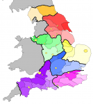
A quite rough WIP [I should have used a thinner line for the main divisions], and a bit of a teaser for a possible future project/story, hence no labels layer yet.

[In b4 "Wot, no Margate sphincter?"]

7CTease.png
 
Good shout - I was checking for a 'General' map thread on the same basis.

A quite rough WIP [I should have used a thinner line for the main divisions], and a bit of a teaser for a possible future project/story, hence no labels layer yet.

[In b4 "Wot, no Margate sphincter?"]

View attachment 10300
Not sure about this Memorandum of Dissent to the Report of the Royal Commission on Local Government.
 
1557268662525.png

I done did this map of what Vichy thought they could get out of WW2 (drawn from a variety of sources).

It essentially amounts to 'OK we're going to have to give Alsace-Lorraine to Germany and concede Morocco, Tunisia and Indochina to some sort of accommodation with the other Axis powers, but in return we're definitely going to get Wallonia, Romandie, and all of the British colonies in West Africa.'
 
Back
Top