-
Hi Guest!
The costs of running this forum are covered by Sea Lion Press. If you'd like to help support the company and the forum, visit patreon.com/sealionpress
You are using an out of date browser. It may not display this or other websites correctly.
You should upgrade or use an alternative browser.
You should upgrade or use an alternative browser.
Cartographicum Thandeum
- Thread starter Thande
- Start date
- Location
- Das Böse ist immer und überall
- Pronouns
- he/him
Should Persia still be in the key?
I decided to update this timeline of partisan control of various elected governments which I first made way back in 2012.
I have learned two things:
1) Not to bother trying to update the key when some countries change parties faster than you can update it. (Looking at you, France; I've given up trying to represent Macron's governments except in the vaguest way)
2) I am glad I did not try to include Italy in this back in the day. Austria was tricky enough given recent events.
View attachment 61797
Stellar work. I especially like how it manages to model the fact that France is a bunch of ramshackle coalitions hidden under neat presidential contests.
If you want to be really thorough, you could throw in the French senate (and the German bundesrat, recent news reminded me they can be relevant to governments' political agenda), but I'm not sure if they have clear mechanisms to identify a controlling/opposition dynamic.
Thanks for pointing that out, still working on this.Should Persia still be in the key?
Yeah I did consider it back when I made this graphic, but my impression was that control of them was not something that really affected political discourse that much (and it was getting very complicated!)Stellar work. I especially like how it manages to model the fact that France is a bunch of ramshackle coalitions hidden under neat presidential contests.
If you want to be really thorough, you could throw in the French senate (and the German bundesrat, recent news reminded me they can be relevant to governments' political agenda), but I'm not sure if they have clear mechanisms to identify a controlling/opposition dynamic.
Yeah I did consider it back when I made this graphic, but my impression was that control of them was not something that really affected political discourse that much (and it was getting very complicated!)
The bundesrat just slapped down welfare reform, if I'm not mistaken. I thought the same but apparently, not when trying to do good things!
The French senate is a bit of a joke since it's designed to both favour rural areas and lag behind a few elections. LREM's senate affiliate hasn't really managed to catch up, for example. But determining who to put on the graph is a bit hard considering it doesn't really have coalition agreements. I guess whoever voted for the current senate president? But that could cleave through senate groups and that would be awkward to count.
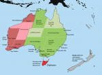
Another LTTW work in progress, for an upcoming update on Antipodea. Been meaning to update this map for years. I do worry I've made it look unbalanced by indicating more cities in Cygnia than in Pérousie, when the latter has a much larger population...most of the settlements in Cygnia are meant to be small outposts.

Last edited:
- Location
- Derbyshire
I reckon if you can work out something in the Coffs Harbour/ Port Macquarie area and (assuming this is now early 20th Century) something inland in either of the Nouvelle Gascognes you'd probably give the impression you want without too much work.
Makemakean
Mr Makemean
- Pronouns
- Logical, unlike those in German
Another LTTW work in progress, for an upcoming update on Antipodea. Been meaning to update this map for years. I do worry I've made it look unbalanced by indicating more cities in Cygnia than in Pérousie, when the latter has a much larger population...most of the settlements in Cygnia are meant to be small outposts.
View attachment 61965
Very much looking forward to this one!
If you need to add things to French Australia though, go for a Monty Python joke, and have the big university town in Pérousie be Brix, since it's after Brix in Normandy that the name Bruce in the British isles is derived.
Crossposted, Scottish Parliament elections 1999 to present.
I started working on this way back in 2016 and then stopped, partly because I was figuring out colour schemes to stop the SNP blending into the Lib Dems (that's why I switched to this LD scale) and then just because the state of Scottish politics was too depressing. I still haven't found more than a handful of the list results by constituency for 2007, assuming they exist (as that one was the infamous cock-up vote-counting one). Still, finally went back to it. Click to enlarge. (UKIP are on the key because I was originally going to try to fit general and European elections on this as well).
View attachment 66202
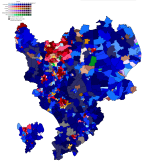
Random map I found while going through some old files - all the 2015 council elections (which were synched to the general election) majorities by ward in the East Midlands on one map. @Alex Richards
edit: in fact Alex may have made this one, as I've just found accompanying heatmap party strength ones which do have his logo on them - whoops!
edit: in fact Alex may have made this one, as I've just found accompanying heatmap party strength ones which do have his logo on them - whoops!

Last edited:
- Location
- Tamaki Makaurau
The only UK election I ever voted in (along with the general) - I helped keep the ward red, but not the parliamentary seat.Random map I found while going through some old files - all the 2015 council elections (which were synched to the general election) majorities by ward in the East Midlands on one map. @Alex Richards
edit: in fact Alex may have made this one, as I've just found accompanying heatmap party strength ones which do have his logo on them - whoops!
View attachment 66229
Remember UKIP?
Crossposted:
Someone, possibly @Nofix, asked a while back about a legislative chart of US gubernatorial partisan holdings I made (checks notes) TEN YEARS AGO. Well, I finally found the file again and updated it. Can't promise there are no mistakes of course, and I've also taken the liberty of filling in all of 2023 already, so nobody is allowed to die or resign in the next nine months.
(Click to enlarge)
View attachment 66576
Makemakean
Mr Makemean
- Pronouns
- Logical, unlike those in German
A bit of a big thing to ask of you, Tom, but seeing you've made so many of these maps, have you considered putting any of them together in the form of youtube videos, timelapses?
Like this, but for US governors or senators or whatever?
I mean, you probably already have the maps, so you really just need to import them into some video-making software and add some background music, really.
Like this, but for US governors or senators or whatever?
I mean, you probably already have the maps, so you really just need to import them into some video-making software and add some background music, really.
A bit of a big thing to ask of you, Tom, but seeing you've made so many of these maps, have you considered putting any of them together in the form of youtube videos, timelapses?
Like this, but for US governors or senators or whatever?
I mean, you probably already have the maps, so you really just need to import them into some video-making software and add some background music, really.
Basically I watch a lot of Youtube and what creators say about it has put me off ever making more Youtube videos, even if it's for something as seemingly inoffensive as that.
I also get a funny feeling seeing videos like that one when they have 5 million views and I realise I picked some of the colours they're using back in 2005
Is the East African country marked as independent? Dark cyan for Bengal? Also how do you do a consistent striping effect?Working on the map for the current LTTW volume (or the start of it/end of the previous one, to be precise).
I'm thinking I might need some extra colours, maybe for Bengal. Talk about deja vu...
View attachment 61885
Last edited:
Sorry, I didn't see your comment till now. Thanks for the cyan suggestion. Do you still want me to explain the striping effect, as I'm happy to.Is the East African country marked as independent? Dark cyan for Bengal? Also how do you do a consistent striping effect?
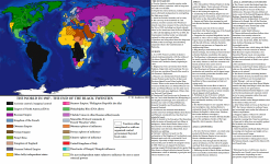
Finally finished that LTTW map. The reason why I found it hard to work on was that it feels wasteful to me to sink hours of work into just sorting out corners of a map like this when I could be writing. As a result, it's now already about 30 years out of date and now I need to make another one for the end of Volume IX 

Interesting map of India's railways from 1915 I found: https://www.davidrumsey.com/luna/se...no_initialsort,pub_date,pub_list_no,series_no
@Indicus @Radac @SinghSong @Ares96
@Indicus @Radac @SinghSong @Ares96
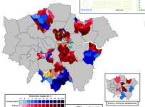
Little preview of something I've been working on for literally years and am coming back to in between the modern stuff. London local elections in 1978 and 1982, before and after the rise of the Liberal-SDP Alliance. (Also held in the middle of the Falklands War).
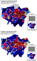
I haven't filled in that box of 'councillors elected' yet and not sure whether to drop it as it's tedious to do so. I also need boundaries for Enfield in 1978 - unlike every other borough, it failed to change its boundaries for 1978 and I find it very hard to get good sources for the pre-1978 borough boundaries.

I haven't filled in that box of 'councillors elected' yet and not sure whether to drop it as it's tedious to do so. I also need boundaries for Enfield in 1978 - unlike every other borough, it failed to change its boundaries for 1978 and I find it very hard to get good sources for the pre-1978 borough boundaries.
Last edited:


