Jackson Lennock
Well-known member
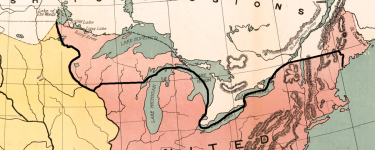
For a stretch along the US-Canadian border from the St Lawrence River to the State of New Hampshire, the US-Canadian border is along the 45th Parallel. What if (with slight adjustments) this was the case from the Kennebec in the East to the Mississippi in the West?

These are still fairly empty areas. North and east main was fairly empty at this point, and the Kennebec was the traditional boundary of Acadia and the British Colonies. The British had also considered the creation of a New Ireland Colony in East Maine OTL, though they used the Penobscot River as the marker IIRC.
Downstream, I doubt the 49th parallel would be used like historically.
Here, Britain has a significant western port at Duluth as a gateway to the prairies, and the possibility of a (mostly) overland route if they build a bridge from Northern Ontario into the Upper Peninsula.

