• Hi Guest!

    The costs of running this forum are covered by Sea Lion Press. If you'd like to help support the company and the forum, visit patreon.com/sealionpress

[ASB] Sea level drops by 50 metres in the early 20th century

fluttersky

Well-known member
Pronouns
they/any
Inspired by the novel Flood by Stephen Baxter, but in the other direction...

Let us imagine that over a ten year period between the year 1900 and 1910 or so, the global sea level gradually drops by around 50 metres and then stabilizes at the new level. The drop starting off slowly, then speeding up, then finally slowing down again. One can explain it by an underground ocean of porous rock opening up- certainly scientists of the time won't have any better explanation– and it avoids the standard ASB scenario problem of "obvious act of God"

Geographically the most interesting/major implications of this are: Great Britain and Ireland becoming connected to mainland Europe (with the southern third of the North Sea becoming land), Australia and Papua New Guinea similarly becoming connected, Sumatra/Java/Borneo now being the end of the mainland Southeast Asian peninsula, several Caribbean islands growing such as the Bahamas becoming one island larger than Cuba, Sakhalin becoming a peninsula of mainland Russia with Hokkaido very nearly joining up with this too; and the Bering Strait closing thereby giving North America a land connection with Asia.

The interesting thing about this happening in the 1900–1910 era is that it would massively change the nature of WW1 if it even happens. I think the greater interconnectedness of the world's landmass may mean national attitudes shifting– the UK isn't an island any more and would be forced to lose the island mentality whilst building a railway from London to New York via Russia suddenly becomes viable– difficult terrain in Chukotka/Alaska for sure but it still seems likely that somebody would try it.

On the other hand there's certainly a possibility of war erupting over the demarcation of borders in the newly dry lands– what with the UK, France, Belgium, Netherlands, Germany, and Denmark all likely wanting the best they can get in Doggerland for example.
 
How gradual or realistic would be the drop?

In particular, would the coastal withdrawal allow for fleet displacement over new coasts and would the drop be roughly previsible enough to plan for new harbour infrastructures?
Would the new lands essentially be swamps or alluvium for the foreseeable future, making them pretty much uninhabitable or barely workable without massive infrastructure?

Even if gradual, that would make me thinks that while it would massively change things, the first, probably the firsts, decades would be about understanding and managing what happens rather than reaping the new opportunities and fighting over it. If anything, I wonder if, in western Europe at least, it wouldn't provide such an investment boom (would it be only for required infrastructure for land reclamation, bonification, canals, etc.) that the increase in military expense or any industrial investment would be sidelined and could very well prevent an European-wide conflict comparable to WW1 to happen.
 
Suez will be high and dry.

Panama canal will require a whole lot more digging and is probably impractical.

Most if not all existing ports are high and dry, utterly disrupting trade and immigration.

How long do we wait to see if it's permanent before we react?
 
Let us imagine that over a ten year period between the year 1900 and 1910 or so, the global sea level gradually drops by around 50 metres and then stabilizes at the new level. The drop starting off slowly, then speeding up, then finally slowing down again. One can explain it by an underground ocean of porous rock opening up- certainly scientists of the time won't have any better explanation– and it avoids the standard ASB scenario problem of "obvious act of God"

Increasing desertification, decreased rainfall, loss of fishing grounds, a coastal ecocide.
 
How gradual or realistic would be the drop?

Something like 1 metre in 1900, 3 metres in 1901, 5 in 1902, 6 in 1903, 7 in each of 1904-06, 6 in 1907, 5 in 1908, 3 in 1909, 1 in 1910.

Less than a centimetre per day for the first two years should make moving boats easy enough
 
Something like 1 metre in 1900, 3 metres in 1901, 5 in 1902, 6 in 1903, 7 in each of 1904-06, 6 in 1907, 5 in 1908, 3 in 1909, 1 in 1910.

Less than a centimetre per day for the first two years should make moving boats easy enough
Does the ASB include people realizing what happen pretty quickly at the start of the change, or is it let to their own appreciation and analysis? If not so, I'm not so sure moving boats every day on what's essentially a wet, salty swamp would be easy. If so, of course, well they might just move them straight away to the new shorelines, obviously.
 
Does the ASB include people realizing what happen pretty quickly at the start of the change, or is it let to their own appreciation and analysis? If not so, I'm not so sure moving boats every day on what's essentially a wet, salty swamp would be easy. If so, of course, well they might just move them straight away to the new shorelines, obviously.
I would say people just figure it out as it happens– ASB influence is intended to be minimal so that people can pass it off as just an unusual geographic event and proceed with life as normal rather than the stronger impact of people knowingly witnessing an act of God.

When it comes to valuable ships (ocean liners, military, etc) I expect the value of them would be enough that the owners would indeed regularly move them (or leave them out at sea for extended periods). Smaller boats would probably end up stranded.
 
When it comes to valuable ships (ocean liners, military, etc) I expect the value of them would be enough that the owners would indeed regularly move them (or leave them out at sea for extended periods). Smaller boats would probably end up stranded.

The Solent is 46 metres deep, Portsmouth shallower still, the Clyde just 9 metres, so that's the end of Britain as a major seafaring power.

Japan also.

Britain manufactured 60% of the world's shipping fleets as late as 1913, and now these shipyards, all on river estuaries, have been left high and dry, literally.

Climate changes would happen but probably not be extremely drastic considering the sea level being that level has been very common historically

The sea level drop would wipe out most coastal colonies of fish and seabirds, not to mention destroying the fishing industry's ability to get at what stocks might remain in the deeper parts of the ocean.

Fish meal was/is a leading source of fertiliser, as was guano, so expect an agricultural catastrophe, as well.
 
Last edited:
Extinction level events are also very common historically and this is one going to be one of them.
Well, given one of Earth's six mass extinctions is in process anyway, it would just further contribute to that. I expect the biggest decline would be in the sort of wildlife that flourished in intertidal areas (Waddenzee etc), as that's the category least able to adapt (whereas one would expect deep water fish populations to recover soon enough).

The Solent is 46 metres deep, Portsmouth shallower still, the Clyde just 9 metres, so that's the end of Britain as a major seafaring power.

Japan also.

Britain manufactured 60% of the world's shipping fleets as late as 1913, and now these shipyards, all on river estuaries, have been left high and dry, literally.

I think when it comes to existent shipyards, the Thames-Rhine area would remain in a relatively better shape, as the Rhine will definitely remain navigable and to an extent the Thames most likely would too.
 
I think when it comes to existent shipyards, the Thames-Rhine area would remain in a relatively better shape, as the Rhine will definitely remain navigable and to an extent the Thames most likely would too.

In the case of the Thames, nope.

Location Limiting Depth
Millwall Cutting 3.5 metres
Millwall Bridge 3.5 metres
Glengall Bridge Cutting 3.5 metres
Heron Quay Canal 2.4 metres
Bellmouth Passage 4.4 metres
Blackwall Cutting 9.6 metres
Eastern Access Bridge 9.6 metres
Poplar Cutting 7.0 metres
West India Quay Bridge 8.5 metres

The Port of London will be the first to go.

Where will trawlers, cargo ships, & naval ships harbour in the aftermath of this event?

As Britain imports most of its food from its empire, and most of its fertiliser, mass starvation in the British Isles is a given, especially Ireland.
 
Well, that butterflies away the Russo-Japanese War....

Oh shit, I'm getting reports that the Japanese fleet is stranded, and there's a land bridge between Sakhalin and Hokkaido, it's back on like Donkey Kong.

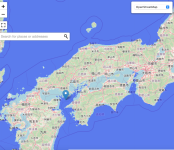
The capacity for ships, both civilian and military, to function in the event of an unstable sea level leading to presumably temporary wooden port facilities regularly moving, is quite an important question in this ISOT scenario for this reason among others. Japan has the advantage that parts of the Seto Inland Sea are more than 50 metres deep and will continue to be a relatively safer place for ships than the open ocean- the Russian Far East doesn't seem to have anything like that.

The closest equivalent the UK has is probably Loch Fyne.
 
Japan has the advantage that parts of the Seto Inland Sea are more than 50 metres deep and will continue to be a relatively safer place for ships than the open ocean- the Russian Far East doesn't seem to have anything like that.

Let's be optimistic and put the sea level dropping by just 49 metres.

Screenshot 2024-03-03 at 19.35.46.png

I think the Imperial Japanese Navy will be walking to work over stagnant marshland. Good luck to 'em!
 
In the case of the Thames, nope.

Location Limiting Depth
Millwall Cutting 3.5 metres
Millwall Bridge 3.5 metres
Glengall Bridge Cutting 3.5 metres
Heron Quay Canal 2.4 metres
Bellmouth Passage 4.4 metres
Blackwall Cutting 9.6 metres
Eastern Access Bridge 9.6 metres
Poplar Cutting 7.0 metres
West India Quay Bridge 8.5 metres

The Port of London will be the first to go.

Where will trawlers, cargo ships, & naval ships harbour in the aftermath of this event?

As Britain imports most of its food from its empire, and most of its fertiliser, mass starvation in the British Isles is a given, especially Ireland.
The capacity for ships, both civilian and military, to function in the event of an unstable sea level leading to presumably temporary wooden port facilities regularly moving, is quite an important question in this ISOT scenario for this reason among others. Japan has the advantage that parts of the Seto Inland Sea are more than 50 metres deep and will continue to be a relatively safer place for ships than the open ocean- the Russian Far East doesn't seem to have anything like that.

The closest equivalent the UK has is probably Loch Fyne.
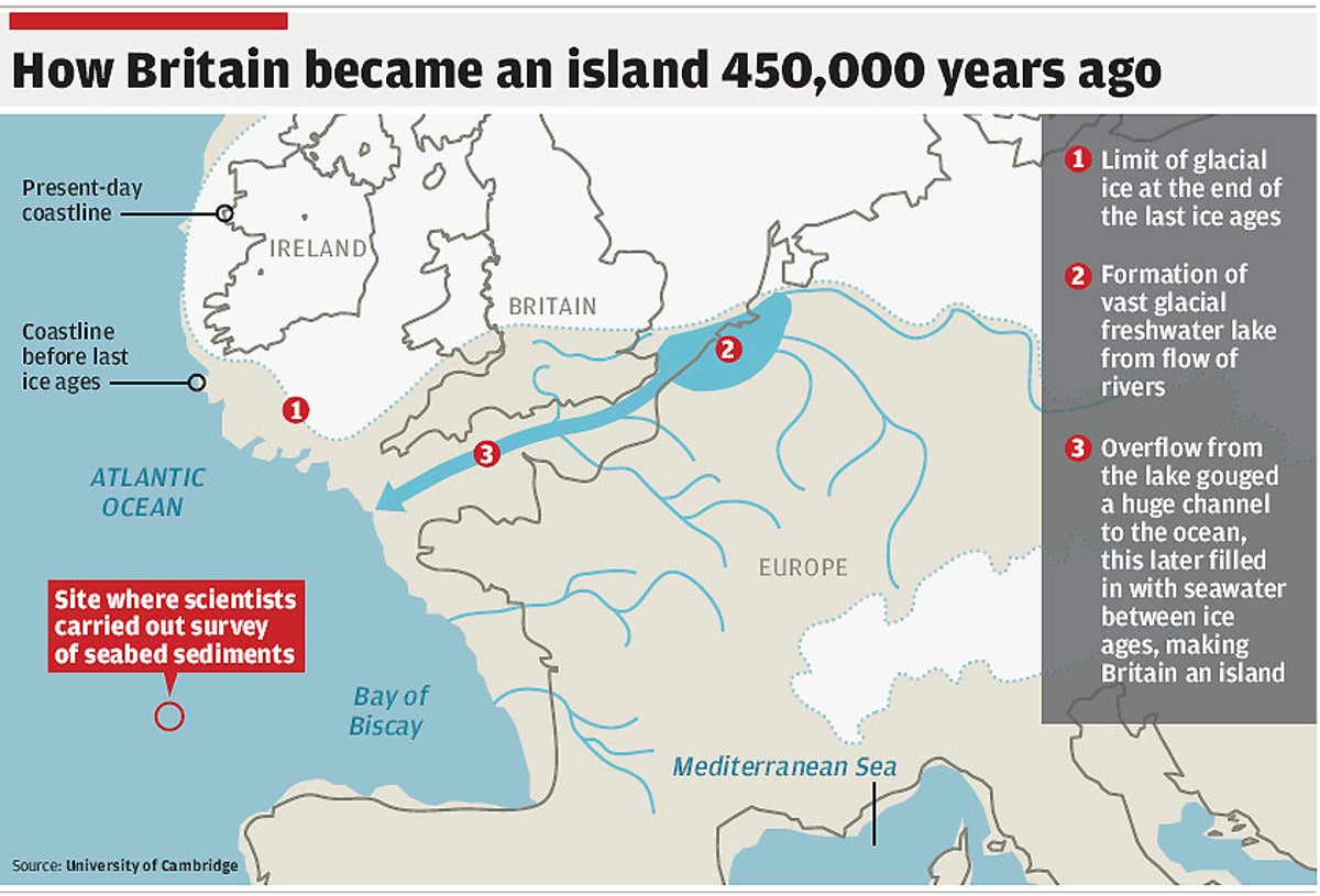
Doesn't it still have the English Channel River in this TL though? The course of which'd still be mostly underwater?

269481.jpg


The-English-Channel-River-system-and-selected-north-west-European-rivers-during-the-last.png


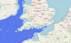
And looking at the map at -50m Sea Level, it's also worth noting that the Irish Sea'd still be semi-enclosed and navigable to a greater extent than the Seto Inland Sea. With Northern Ireland now connected with Scotland via the Isle of Islay peninsula, but with St George's Channel and the Celtic Sea still open for business. And perhaps the best positioned port city in the British Isles to re-construct its docks downriver, ironically enough, would be the city of Dublin- with the -50m reduction of sea levels creating a natural bay right at the new mouth of the River Liffey.

lossy-page1-800px-Irish_Sea_%E2%80%93_relief%2C_ports%2C_limits.tif.jpg


And the resurrected River Solent'll itself still run south all the way to the new bay/delta of the English Channel even ITTL, via the pre-established Paleo-Solent Valley- with the 'Solent Valley' itself set to become more similar to the Thames Valley IOTL, you'd thus expect maritime activities at 'high-and-dry' ports and docks of Southampton (and probably) Portsmouth to migrate downstream to the new (/old) mouth of the river, with all its previous tributaries re-united once more...

o1_bhXjy20AxXhyz1ts4YqoIbdVJ2h7jiWAs284nZOK43UgWKJ0qcH_TgmY3u36KCwyR5RwqJnXIxgFtQCkIB8Y9-CcNt51Wb1GEOuTZXQur-4fvuMXrvdX0avxHCVfX4QLLKQABwF2tyPXuti8ySTawXITaFJdzF1Dfk1Ls-1bVWMOMgmwVcA
 
How do the ships in the docks and slipways at London, Southampton, Portsmouth, Dover, Cardiff, Bristol, Hull, Liverpool, Dublin, Queenstown, Middlesbrough, Glasgow etc get to it, however?

On wheels?

Remember that this scenario involves the sea level dropping gradually, not suddenly. They'd probably have stay anchored at sea a lot until the sea level stabilizes and then new ports would steadily grow.
 
Last edited:
Remember that this scenario involves the sea level dropping gradually, not suddenly. They'd probably have to stay anchored at sea a lot until the sea level stabilizes.

How do ship-owners/ship builders know where to anchor their ships, without knowing how much the sea level will drop? The tide will go out, and not come back.

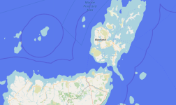
Also: Scapa Flow - gone.Screenshot 2024-03-05 at 21.39.39.png

The number of viable roadsteads and anchorages will decline, and become too shallow for the draughts of laden ships, and will become crowded with beached and grounded ships. How do ships at sea know where to dock?
 
Back
Top