• Hi Guest!

    The costs of running this forum are covered by Sea Lion Press. If you'd like to help support the company and the forum, visit patreon.com/sealionpress

AH Challenge: What border quirks can you think of?

Hendryk

Taken back control yet?
Published by SLP
Location
France
AH worldbuilders generally like their borders neat and tidy. But in real life borders sometimes have weird quirks to them, the result of unsatisfactory compromises, unresolved disputes, mere oversights, or even just the cartographers doing a half-assed job. The French-Spanish border famously has Andorra, perhaps the only country in the world with a monarch that's democratically elected by the citizens of another country, but is also graced with a number of other oddities such as the town of Llivia, which due to rules lawyering is part of Spain even though it is on French territory, or Pheasant Island, which is French half the year and Spanish the other half.

What are similar quirks that could plausibly show up in AH works?
 
Two "state gerrymanders."

One is the chunk of unionist counties in North Alabama being plucked out to allow for two GOP/northern-friendly Senate seats in what would be by far the smallest state in the union.

Another is breaking Tennesee into two states, given how Unionist and consistently Republican the east has been. (This I'm thinking of as a counterbalance to DC statehood, by making an ultra-red area its own state to get votes for the district proposal).
 
A couple of years ago, I was looking into the historic borders of Sweden in the East. In the very northernmost part, by the coast, there were pretty detailed specifications to be found, and in the south, in Karelia, there were similarly some very detailed specifications. But much of the historical border between Finland and Russia has been very unspecified, because most of that area had been entirely unexplored until the late 19th century. In looking over some old maps, I kept finding this place called Lake Måmeljaur which I couldn't find on modern maps, which was supposed to be very near the border between Finland and Russia. Now, those old maps often got the latitudes and longitudes completely wrong, so it was completely possible that I was looking in the wrong place I figured. Maybe Lake Måmeljaur was an old name for a lake that currently had another name or something.

I eventually found the whole confusing matter explained in a book I found, which explained that Lake Måmeljaur started to appear on maps in the 18th century, and continued to appear on them until the early 20th century, when it was determined that the place did not exist. See what had happened was that whenever they were making a new map of the area, they didn't properly try to explore it, and would just copy previous maps, and it was first with the advent of modern aviation and proper landsurveying that it was concluded that, yeah, no such lake actually existed.

The clues had been there all along, seeing the very name Lake Måmeljaur is ridiculous, seeing it is gibberish in all three of Swedish, Finnish and Sami.

I decided that this geographic curiosity had some potential, and so I made it so that when they redraw the previously ambiguously defined border between Sweden and Russia (as in OTL) in the Swedish Strangerverse in 1859, they define it explicitly so that it goes through Lake Måmeljaur. This of course eventually leads to people trying to find Lake Måmeljaur, and there is this entirely triangular area up in Lapland where it's unclear whether the Russians or the Nordic Empire have jurisdiction, and so criminals use it as a safe zone.

I wrote a story about it.
This is (almost) what happened with the aforementioned US-Canadian border, which was originally defined as starting at the northwestern edge of the Lake of the Woods (which turns out to be an irregular shape where it's difficult to say where the northwestern edge is) and going west to meet the Mississippi...which, it turns out, is east of the lake.
 
Since we're all geeks here I don't think I need to mention Bir Tawil, which is the result of a mapmaking error.

I don't know if that's where the inspiration comes from, but there's a French graphic novel called L'Or du Macho Fichu in which the story takes place in a South American microstate that came into existence when a UN official spilled his drink on a map, drunkenly inked around the resulting stain, and nobody noticed until it had become a real country.
 
"Lost Dakota" is an interesting one. It was a tiny, uninhabited piece of forest in modern-day Montana near its tripoint with Wyoming and Idaho, about the size of Manhattan in terms of land area and supposedly infested with grizzly bears. The area was originally placed in Dakota Territory by local surveyors but when Wyoming Territory was split from Dakota Territory in 1868 the new territory's western border was placed in its modern location at 104°3'W, leaving this uninhabited patch of forest outside of it and therefore legally still in Dakota despite being cut off from the rest of the territory by the entirety of Wyoming. The issue was fixed when officials in neighboring Gallatin County, Montana Territory noticed the anomaly and formally annexed it in 1873, but for around five years nobody noticed it. I could easily see something similar happening in a different neighboring county due to circumstance, resulting in it being annexed to Wyoming or Idaho instead, but that's pretty underwhelming. What I think the most interesting possibility for this anomaly might be is that nobody notices it (or at least nobody cares about it) until after 1889, when North Dakota and South Dakota were admitted to the Union as states. Since the U.S. Constitution prohibits the transfer of legally held territory between states without the consent of the legislatures of all states involved and of the U.S. Congress, Lost Dakota was never legally transferred from Dakota Territory to another territory or state before its statehood in this scenario, and the area lies below the survey line at 45°56'07"N which defines the border between North Dakota and South Dakota, it's pretty easy to conclude that Lost Dakota would legally still be part of South Dakota in this scenario until explicit agreement otherwise is given by South Dakota, another state, and the U.S. Congress. So you'd end up with a Manhattan-sized piece of forest near Yellowstone National Park inhabited by nothing except trees and grizzly bears which is part of a state entirely located over 200 miles away from it for no other reason than because everyone forgot to say otherwise and it's too much of a headache to change now.
 
Last edited:
Sedudu Island, AKA Kasikili Island, in the Chobe River on the Namibia Botswana border, was disputed between the two countries from Namibian independence until they agreed to jointly approach the ICJ in 1996.

The 1890 Anglo German treaty specified that portion of the border as the Chobe thalweg but nobody ever worked out the details. As international tourism in the Chobe grew it did become more important, and became a dispute.

The ICJ appointed hydrologists and surveyors and after 3 years ruled that the thalweg lay to the north, and the island was in Botswana.

To note that most years between March and May, the location is not Botswanan land, but rather territorial waters as the island is fully submerged three months of the year
 
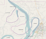
Then we have the Songwe river, which forms the land border between Tanzania and Malawi, under the same Anglo-German treaty. The problem here isn't defining the river channel - it's that the river channel moves. A lot. There's a village that has ended up changing countries...
 
Then we have the Songwe river, which forms the land border between Tanzania and Malawi, under the same Anglo-German treaty. The problem here isn't defining the river channel - it's that the river channel moves. A lot. There's a village that has ended up changing countries...
The alternative is what they do in the US, where it was decided to leave the Arkansas-Tennesee border where the river used to be...

1661859989549.png
 
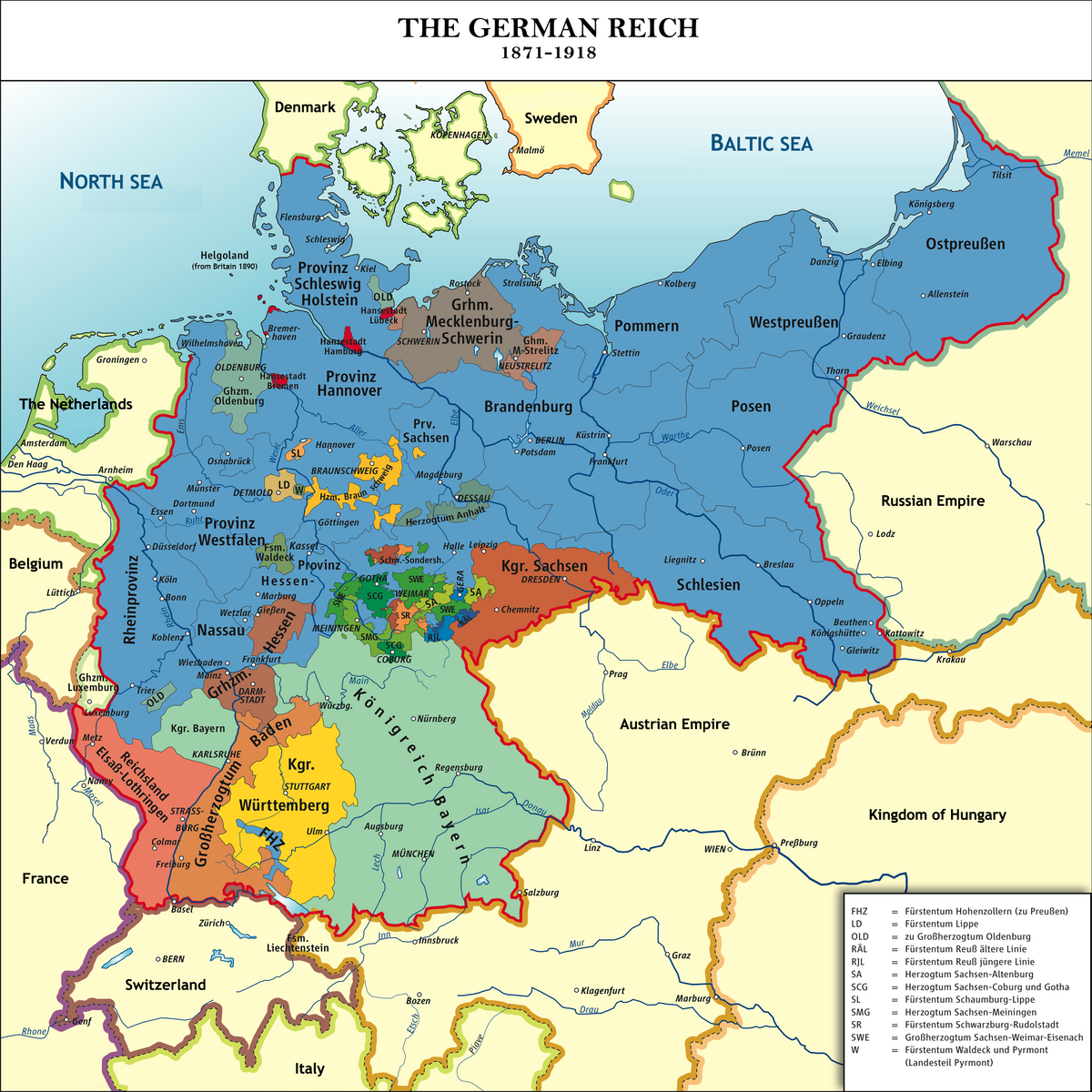
I don't think there can be anything so complex as the pre-unification borders in Germany.

The complicated enclaves and exclaves of Belgium with adjoining Netherlands looks like something from 'The City and The City.'


Not a boundary, but the election of the Doge of Venice was pretty convoluted

Thirty members of the Great Council, chosen by lot, were reduced by lot to nine; the nine chose forty and the forty were reduced by lot to twelve, who chose twenty-five. The twenty-five were reduced by lot to nine, and the nine elected forty-five. These forty-five were once more reduced by lot to eleven, and the eleven finally chose the forty-one who elected the doge.

Election required at least twenty-five votes out of forty-one, nine votes out of eleven or twelve, or seven votes out of nine electors.

 
Back
Top