• Hi Guest!

    The costs of running this forum are covered by Sea Lion Press. If you'd like to help support the company and the forum, visit patreon.com/sealionpress

Max's election maps and assorted others

Ah I was wondering if we’d have in-depth looks at southern Germany and glad you did write them.

Could we expect some state election results as well? Or this is this all we’re getting for some time?
Not in this level of detail, but there might be some additional maps of the 1928 election beyond just the strongest-party map.
 
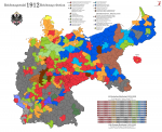
Reichstagswahl 1912 (no shades)
I decided it might be a good idea to adapt the pre-war electoral map to the new base. Of course, a fair few urban constituencies are possibly too big, seeing as how they were based on 1870 boundaries right up until the end. This also made it a hell of a time to map those states that had boundary reforms between 1870 and 1900, which was mainly Saxony and Hessen-Nassau (Mecklenburg-Schwerin was also terribly annoying, but for unrelated reasons).

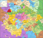
Also, Thüringen is incredibly confusing, but there's only so much I could do about that.

val-de-1912.png
 
I found a historical atlas of Hessen earlier today, and it has some doozies:

40.jpg
 
Would it be possible to request that you make a map of the relative population in the different constituencies, from relatively few people there, to relatively many? Would be interesting to see.
 
Would it be possible to request that you make a map of the relative population in the different constituencies, from relatively few people there, to relatively many? Would be interesting to see.
I agree, unfortunately I don't have complete data for that. Some of them you could calculate based on the populations of the administrative divisions they're made up of, but quite a few states had boundary changes since the constituencies were drawn up.
 
Back
Top