• Hi Guest!

    The costs of running this forum are covered by Sea Lion Press. If you'd like to help support the company and the forum, visit patreon.com/sealionpress

Max's election maps and assorted others

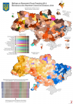
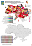
Here's my progress on 2014. Turns out the table of results by raion was only there for the 2012 election, so if @vjw or someone else in the know can point me to a results service that works (I was able to find an interactive map that used Adobe Flash, which of course means it's currently unreadable), I'd be very grateful.

val-ua-2014.png
 
Here's my progress on 2014. Turns out the table of results by raion was only there for the 2012 election, so if @vjw or someone else in the know can point me to a results service that works (I was able to find an interactive map that used Adobe Flash, which of course means it's currently unreadable), I'd be very grateful.
Quite easily found a book on this election (results by raion are on pg. 584-737), although it is easier to use this resource
 
Last edited:
Not entirely satisfied with the colour scheme on this, but I'm choosing to say this is Ukraine's fault and they need to eliminate at least three parties. I am not a crackpot.
I believe you. In a country with 370 political parties, of which God forbid 10 are active, and where electoral cycles change the face of the country, you have to be prepared for anything.
 
I find it impressive just how much it's obvious that Ukrainian politics just sort of broke- the massive increase in independent constituency MPs for example.
I think that's less a sign of politics in general breaking and more a sign of the Party of Regions breaking - as you can tell from the 2012 map, they tended to be a lot stronger in the constituencies than in the list.
 
A minor update to the Austrian map, at long last. Moravia still terrifies me, but I imagine I'll get to it eventually.
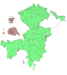
reichsrat.png

Austrian Silesia, as the name implies, was the portion of Silesia that remained in Austrian hands after the Seven Years' War. Its borders made no sense even in 1907, and that was after the horrifying mess of duchies and principalities that had previously made it up were abolished during the post-1848 reorganisations of the Empire. Its capital was the city of Troppau (Opava in Czech, which is its current official name), and it consisted of two roughly equal slices of land, one of which straddled the northeastern border against German Silesia, while the other was a rough square bound by the rivers Biala in the east and Ostravice in the west. This meant there were urban areas along both its western (Ostrau/Ostrava) and eastern (Bielitz/Bielsko) borders, and this in turn ensured Austrian Silesia wasn't long for this world once the Empire collapsed. So did its ethnic composition - a plurality, though not a majority, of the duchy's population spoke German, mainly in the western half but also in a linguistic enclave around the town of Bielitz (this is why the area around Bielitz forms an exclave of district 10 on the electoral map), while Poles and Czechs both made up significant minorities. After the war, the majority of Silesia became part of Czechoslovakia, though the eastern half was split along the river Olza - this compromise border ironically splits yet another urban area in half, and the city of Teschen/Cieszyn/Těšín remains split down the middle between Poland and the Czech Republic to this day.
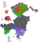
val-at-1907.png
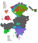
val-at-1911.png

Politically, Silesia was similar to the mountainous regions of Bohemia - like them, it was a prosperous mining region, where class consciousness as well as national affiliation played far more significant roles in politics than the Church. In 1907, it was one of the strongest regions for the Social Democrats, who managed to elect members representing their German, Czech and Polish branches from different parts of Silesia. The towns, however, had a significant German nationalist presence, while German and Czech agrarian candidates were both able to win seats in more rural areas. In 1911, just as in Bohemia, it seems as though national feelings were on the rise, as the Social Democrats lost seats among all three nationalities, with the Polish People's Party making their first appearance on our map (although they'd already won a significant number of seats in Galicia in 1907).

Also making their first appearance was the German Workers' Party, who actually also won a couple of seats in Bohemia that I mistakenly identified as agrarians last time (DA vs DAP, easy mistake to make). This was a fairly odious collection of radical German activists from the industrialised parts of German Bohemia, Moravia and Silesia, who were convinced the mainstream German nationalist parties weren't doing nearly enough to combat the scourge of the Church, the capitalist class, the Slavs, the Jews and the Marxists. Exactly which of these groups they wanted to fight varied a bit over time, but suffice it to say it's not really an accident that their name was taken by the forerunners of the Nazi Party. They frequently used the term "national socialism" to describe their ideology, and indeed there were several attempts to add this phrase to the name of the party, but these were always defeated because of the risk of confusion with the similarly-named Czech party. After WWI, they did, in fact, add it, and the resulting DNSAP became a small but influential player in Sudeten German politics within Czechoslovakia, eventually forming the kernel of Konrad Henlein's Sudeten German Party.
 
Last edited:
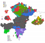
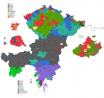
Here's Moravia, then. I don't imagine I'll be wanting to look at this map for a while, but I promise I'll eventually get to Galicia, the Bukovina and Dalmatia so that we can actually call the damn thing finished. As with Bohemia, a lot of these town boundaries are at least a little bit conjectural - this would be a whole lot easier if I had a map of Czech cadastral districts, but I don't, so.

reichsrat.png

Moravia was one of the two big oddities in the Cisleithanian electoral system (the other being Galicia - which, again, we'll get to). Much like Bohemia, it was split between a Czech majority and a large German minority, and like Bohemia, the Germans were mainly concentrated along its northern and southern borders. However, unlike Bohemia, Moravia also had a large number of German-speaking enclaves in its central regions, some urban and others rural. Evidently, this was enough for the officials who drew up the electoral law to decide that a language border could not be easily drawn, and so they went for a very "Gordian knot" solution. They simply drew two separate sets of constituencies, one for the Czechs and one for the Germans. I don't know how they decided who would end up on what electoral roll, but only 1% or so of the population spoke neither Czech nor German natively (most of them Poles from the region around Ostrava), so it was not as big a problem as one might think at first sight. Each set of constituencies had ten urban seats, and then the Czechs got twenty rural seats and the Germans nine, which was somewhat more skewed toward the Germans than the demographics would suggest, but not that much so.

val-at-1907.png
val-at-1911.png

Moravia had (and still has) a slightly more conservative reputation than that of Bohemia, and this showed on the electoral map. While the Bohemian countryside was dominated by the Agrarians from day one, the rural Czech seats in Moravia were split between them, the Catholic People's Party (labelled as "Czech Clericals" on nearly all contemporary maps) and the Old/Young Czech parties. The towns had a similar split, with the Social Democrats taking the place of the Agrarians, and in 1911 the Catholics lost ground to both the Agrarians and Social Democrats while the Radicals and National/People's Socialists made gains from the old establishment parties.

The German seats, meanwhile, were dominated by German nationalists to an even greater degree than those in Bohemia. The mining region around the Sudetes elected a couple of Social Democrats in 1907, but these were all defeated in 1911. So was the single Christian Social MP elected from seat D18 (which I think would've been dominated by the language isle around Iglau/Jihlava), one of their very few elected members outside of what would become Austria post-war.
 
My understanding was that the split between Czech and German seats was not so much the unwillingness or impossibility for Austrian mapmakers to find sufficient ethnic islands, but a reflection at the imperial level of the Moravian Compromise of 1905, which split the seats to be elected by the general curia in the Moravian Diet between ethnic German and ethnic Czech ones (I think on a 2:1 basis?) while ensuring equal funding for all cultural and education institutions.

IIRC, back then and now, the compromise was seen as a model for the notoriously dysfunctional Bohemian Diet but failed because ethnic tensions in Bohemia were much higher owing to the larger share of Germans in Bohemia and the much important socio-economic position of Czechs compared to more rural Moravia where the traditional bourgeois and aristocracy classes remained largely German.
 
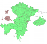
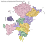
Instead of continuing to push east, I decided to try and make a basemap of the Habsburg-era districts in the areas I've already done. I think it turned out pretty well - there are areas where I'm unsure how exact this is (present-day Slovenia being the big one), but most of it should be reasonably close.

One thing I find notable is how little change there's been since 1914 in present-day Austria. Except for the districts around Vienna and a couple of other ones (Pöggstall and Gröbming have both been subsumed into neighbouring districts, and there's been some boundary adjustments in Upper Austria), the administrative districts are essentially the same now as they were a hundred years ago. Pretty striking in comparison with Germany - then again, unlike in Germany, Austria's districts don't actually have self-government, so it makes some sense that the drive to merge them has been less.

österreich-bezirke-1914.png

EDIT: Discovered a couple of arrows and abbreviations I hadn't added before.
 
Last edited:
Bit more Hungary. I've since discovered that someone already made an absurdly detailed map (not linking the image directly, it's that big) and put it on Wikimedia Commons, so that'll hopefully be a useful resource for me as I finish this.

osterreich-bezirke-1914.png
 
Back
Top