• Hi Guest!

    The costs of running this forum are covered by Sea Lion Press. If you'd like to help support the company and the forum, visit patreon.com/sealionpress

SLP 'Telephone' Maps and Graphics Game 5

So I received that from Gary and ended up considering the long term demographic consequences of a Russian outpost in the med. Like how it could end up being a destination point for Greek and Armenian emigrants, wealthy Yugoslavs and later more diverse expats.

And ended up creating a map showing the ethnic breakdown of this rather more diverse island at various levels.

View attachment 66357

And sent it off to @Wolfram
That is a beautiful and detailed map, Alex. Very much a fan of that, really fleshes out the idea and I'm annoyed I couldn't use that in the microfiction article from last week as it's such a good example of telling a story through a graphic without needing additional words.

The Greek figure seems low given they were 400 Greeks living on British Minorca already who the Spanish expelled to France in OTL, and you'd expect more to come from Corsica/Greece upon the Russian sale. Presumably they became integrated into the russian population and what is marked as greeks in the modern day are more recent settlers, like the distinction between the anglo-irish and the planters?

Checking my notes and I've got a distinct trend for larger 'Greek' populations in the Catalan majority areas.

So the populations work out at about 49,500 Catalans, 26,500 Russians, 9,100 Greeks, 3,500 Armenians 3,000 Yugoslavs and 5,400 others.

But the Russian majority city of Mahon only has 762 Greeks resident there (the small majority Greek village of Santa Anna has 309) while there's 6,889 in Catalan majority Ciutadella de Menorca.

So very much an identity that sits at its strongest where they feel most in opposition to the neighbours.
 
PXk7yUx.png


After getting the text mentioning a newly-independent Crimea following a Revolution and mentions of fairly different groups, I pictured Crimea becoming independent of Russia more than the Ottomans following a referendum with a narrow majority in favour, and mapped it. I believe I calculated it somewhat based on 1897 demographics but I doubt I still have the data.

I interpreted Ruthenian to be a generic terms of Eastern Slavs here.

And then I sent it off to @kratostatic
 
ehQ82Dh.png


So I got a graphic of a Crimean independence referendum, and I inadverently decided to continue the theme by interpreting the country it declared independence from being a Polish-Lithunaian Commonwealth, largely because I considered it to be a more interesting option than Russia and given the demographic data it was unlikely to be the Ottomans.

The result was this slightly defaced campaign poster for a "Better Together" campaign for the Commonwealth (and I'll admit to being a bit cheeky with the logo). I don't think the Crimean or Estonian campaigns were successful... Any issues with translation are of course my responsibility, although I feel like there's a reasonable Watsonian explaination that the campaign badly translated the slogan due to incompetence.

I then sent this off to @Lilitou
 
Commonwealth Map notes.png

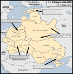
So I recieved the map from @kratostatic and assumed there was a chonky, surviving Poland-Lithuania with some quirky borders, with surviving Muslim Tatars in Crimea and seccessionist Estonians. I wanted to expand on that and give a sort of BBC-style (or, given the state of Europe, NYT-style?) infographic map that laid that out, presumably as part of an article on Estonia's upcoming referendum, while also noting other points of contention; I noticed the Yiddish text, so Krakow and Lwow remain centres of Jewish people in Europe. With the PLC surviving, I also assumed that Russia had been neutered and Sweden still relatively powerful after a presumably very different Great Northern War. I might have relied a bit too much on the textboxes, though.

Regardless, I then sent it on to @zaffre :)
 
View attachment 66395

So I recieved the map from @kratostatic and assumed there was a chonky, surviving Poland-Lithuania with some quirky borders, with surviving Muslim Tatars in Crimea and seccessionist Estonians. I wanted to expand on that and give a sort of BBC-style (or, given the state of Europe, NYT-style?) infographic map that laid that out, presumably as part of an article on Estonia's upcoming referendum, while also noting other points of contention; I noticed the Yiddish text, so Krakow and Lwow remain centres of Jewish people in Europe. With the PLC surviving, I also assumed that Russia had been neutered and Sweden still relatively powerful after a presumably very different Great Northern War. I might have relied a bit too much on the textboxes, though.

Regardless, I then sent it on to @zaffre :)

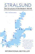
I was drawn to the surviving PLC, HRE & Hanseatic League, and decided to focus in on the different historiography if we've got all these long-standing supranational units floating around. And I especially like when something pre-POD nonetheless takes on a whole different interpretation as a result, so instead of Westphalian nation-states we’ve got the Stralsundian (?) model, after the OTL 1370 treaty - which ITTL represents the continual ascent of the Hansa, rather than their apex. Hence:

stralsund.png
 
I was drawn to the surviving PLC, HRE & Hanseatic League, and decided to focus in on the different historiography if we've got all these long-standing supranational units floating around. And I especially like when something pre-POD nonetheless takes on a whole different interpretation as a result, so instead of Westphalian nation-states we’ve got the Stralsundian (?) model, after the OTL 1370 treaty - which ITTL represents the continual ascent of the Hansa, rather than their apex. Hence:

View attachment 66422

I will confess I did not twig to any 1370 treaty aspect of this, but I did grasp that this was a Europe not as we know it, with such pre-modern powers as the Hanseatic League and PLC, focused on the economic and political prominence of trading empires centered on the Baltic. I'd already decided I wanted my piece to be related to or drawn from some kind of entertainment, so when I got sea empire, I immediately got an early 90s video game about pirates. And, well, let's just be straight here, I played a lot of the 2005 game Mercenaries, where you hunt down an Iraq-style Deck of 52, and that really synergized nicely here. I did use the German playing card suits (leaves, hearts, bells, and acorns) to keep with the Hanse, and chevalier instead of jacks, and a few other touches here and there to keep with the pre-modern-Modern-European feeling that I was getting. My interpretation here wasn't so much that the modern Baltic was overrun by pirates, anymore than the modern Caribbean is, but that as an obviously world-influential setting it would be exciting to play the combination of modern locale with a neo-historical context, in the same sense that a Fallout game leverages the combination of the new and old American West together for story and setting, just here with the Victual Brothers instead of cattle rustling.


w0iycSW.png


And from there to @Excelsior
What I got from this was that there was a period of piracy going on in the modern day. For some reason I assumed the years '06 and '09 were 2006 and 2009 and I decided to explore the reason for 21st century North Sea piracy. And thanks to Gotland and Livonia the general vibe in Europe also matched prior entries. Since these were English pirates, England is kil and it's the former Royal Navy which becomes the terror of Northern Europe.
oqLGvZa.png

This is what I sent on to @Makemakean (still would like to know what you were planning!) and later @Stuyvesant.
 
I was drawn to the surviving PLC, HRE & Hanseatic League, and decided to focus in on the different historiography if we've got all these long-standing supranational units floating around. And I especially like when something pre-POD nonetheless takes on a whole different interpretation as a result, so instead of Westphalian nation-states we’ve got the Stralsundian (?) model, after the OTL 1370 treaty - which ITTL represents the continual ascent of the Hansa, rather than their apex. Hence:

View attachment 66422

I have to say this is a stand out for me in terms of being both a different idea and a very well executed version of it.
 
What I got from this was that there was a period of piracy going on in the modern day. For some reason I assumed the years '06 and '09 were 2006 and 2009 and I decided to explore the reason for 21st century North Sea piracy. And thanks to Gotland and Livonia the general vibe in Europe also matched prior entries. Since these were English pirates, England is kil and it's the former Royal Navy which becomes the terror of Northern Europe.

This is what I sent on to @Makemakean (still would like to know what you were planning!) and later @Stuyvesant.
I decided to focus on the idea of a partitioned England, and figured it would be a very messy Syria-esque situation, ergo Northern Wahhabism.
1678246488469.png
 
I decided to focus on the idea of a partitioned England, and figured it would be a very messy Syria-esque situation, ergo Northern Wahhabism.
View attachment 66530
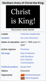
So I got a wikibox of a Puritan terrorist group in a partitioned England. I decided this must mean England was, for some reason, partitioned on religious lines over the disagreement of Protestant groups - judging by this group operating in "West England", on a Protestant East and a Catholic West. Also, judging by it being a "Northern Army of Christ", I reasoned there was a single "Army of Christ" that fought against Partition, failed, and broke up on geographic lines. Also, as for Northumberland, I decided it was under Scottish rule, and this stuck and resulted in its independence.

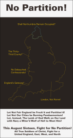
With this summary of events, I had a few ideas - a map of refugee movements on both sides fleeing Partition, or some wikibox of wars between East and West England, but instead I decided to make a propaganda poster by some Protestant fundamentalists opposing Partition. I tried to make it in the style of a 70s poster (including with some 70s fonts) but it didn't really work, and I tried to fill the poster with anti-Catholic innuendo, like Rome being mentioned below - thinking now, I could've just gone for "Stop the Popery of Partition" and it would've done the job better and simpler - and some references to Satan and old-fashioned language to make it sound Puritanical.

1678249968126.png

After this, I sent it to @Caprice
 
So my thought was "huh, some sort of weird Anglican theocratic movement", and my idea was that, after god knows how long a period of extremist theocracy, the English government was starting to do the slightest of liberal things, and all the hardliners were tearing their hair out over it. So my idea was, put together a local government map of the Manchester area based off Anglican dioceses and whatnot, then make, like, some reorganization commission's map of proposals for a new County of Manchester based off the "33rd county" bit in Indicus' map. But wait, surely they'd want to base it off population density or something, which means figuring out population densities, which means fighting British census statistics on top of the work needed to make a good and proper local government map in this style. (I should try something like that, though, on my own time.)

The sandwich shop is in the same place as the stationary store I go to, and I'd need to get a pack of highlighters so I could draw the proposed Manchester county borders because somehow I don't have any highlighters in my apartment, and, while I do not like the sandwich shop employees, they make incredibly good sandwiches and of course I'd get one if I was in that part of town.
 
Last edited:
Back
Top