• Hi Guest!

    The costs of running this forum are covered by Sea Lion Press. If you'd like to help support the company and the forum, visit patreon.com/sealionpress

Max's election maps and assorted others

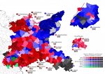
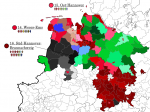
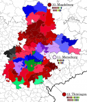
The WKV Sachsen-Thüringen (not to be confused with WKV Sachsen) included the Prussian province of Saxony as well as the states of Thüringen and Anhalt. This is another interesting one, as it's the first region we've looked at that's inside what I call the "Red Triangle" - the central region of Germany, bounded roughly by Hamburg, Frankfurt and Dresden, where the SPD tended to do especially well. This was certainly true of large areas within the WKV, with both the lignite fields around Halle, the small farms and manufacturing towns of the Thuringian Forest and the agricultural estates of the fertile Magdeburg Börde having provided reliable vote banks for the SPD before the war. In the Weimar Republic, however, the KPD provided strong competition in certain regions, particularly the lignite region. The Merseburg constituency actually returned a narrow plurality for the Communists, although in both 1924 elections, vote-splitting on the left had made the DNVP the strongest party. Magdeburg, for its part, was (like several other mid-sized Prussian cities) fairly good for the DVP, although the SPD were very far ahead of them.

Thüringen, meanwhile, was Interesting (TM). The state of Thüringen (which was smaller than the constituency) saw some of the most closely-fought state elections in the Weimar era, being both a stronghold of the old USPD and the first place where the Nazis got a foothold in state-level government (although that was still in the future in 1928). Compared to the Prussian part of the WKV, the DNVP was notably weak in Thüringen, and the right-wing camp tended to be headed up by the Thüringer Landbund, a highly conservative, nationalist, at times heavily anti-Semitic (but I repeat myself) agrarian party, which would be responsible for bringing the Nazis in from the cold in 1930. For the 1928 Reichstag elections, they participated in the Reichswahlvorschlag of the Christlich-Nationale Bauern- und Landvolkpartei (CNBL), which the English Wikipedia falsely claims only emerged after this election - in fact, while it would grow after it, it came about as an alliance of right-wing agrarian movements specifically to contest it, but did grow significantly due to DNVP defections afterwards, as Alfred Hugenberg consolidated his controversial leadership of the party and expelled elements opposed to his openly völkisch, conspiratorial nationalist outlook.

And then, of course, there was the Eichsfeld, the northwest corner of Thüringen, which had been part of the Archbishopric of Mainz and remained heavily Catholic as a result. This made the Centre Party significantly stronger in Thüringen than it would've been otherwise, and ensured they received a seat on the WKV level.
val-de-1928-st.png

Yet another style note - Sachsen-Thüringen being the first WKV we've done that didn't face any of Germany's outer borders means I had to move the constituency names and overviews so as not to make the map pointlessly huge. Hopefully it works this way.
 
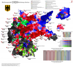
I don't have that much of interest to say about Saxony - it was a very important, very industrialised, very densely-populated state, with not one but two of Germany's biggest cities in it, and also uniformly red on the map. Even the KPD didn't break through anywhere, although they came pretty close in Chemnitz and Pirna. So instead, I'm going to post a complete map of what I have so far, complete with a key! Basic due diligence, can you believe it?

val-de-1928-ny.png
 
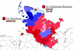
Germany's least populous WKV after East Prussia (probably) consisted of Schleswig-Holstein and Hamburg, each of which formed one constituency (the S-H constituency also included the rural district of Lübeck, still part of the state of Oldenburg). This was the region that saw the most radical demographic change after the war (along with Mecklenburg), with over a third of the population of Schleswig-Holstein in 1950 being made up of expellees from the former eastern territories. As such, it's a bit hard to draw straight lines between its pre-war and post-war politics, and while the map looks similar - redder along the Elbe and in the south of the state, more conservative in the rural north - pre-war Schleswig-Holstein was a very traditionally Prussian region despite having been under the Danish crown until 1864. It shared with the old Prussian provinces a tradition of serfdom and large landed estates, and like those regions, its conservatives went a little bit loopy after the loss of the war (especially since about a quarter of the province was ceded to Denmark). Schleswig-Holstein was the home of the Landvolkbewegung, the smallholders' civil disobedience movement that started in 1927 in response to a foreclosure crisis across northern Germany, which would eventually turn in a völkisch direction and give the Nazi Party one of its early strongholds. Even in 1928, Dithmarschen - one of the most isolated rural areas in the entire north - gave the "Hitler Movement" enough votes to reach second place, although this wasn't enough to get them a seat in the province.

Hamburg, meanwhile, was an early and prominent stronghold of the SPD, and much like Saxony (the other pre-war SPD stronghold state), stuck by the party through the 1920s. Its Hanseatic heritage and the lack of a local aristocratic or military tradition meant that Hamburg's right wing was very different from its Prussian counterparts, with the DVP and DDP both winning significant ground and the DNVP weaker than in most of the surrounding regions - or indeed in Berlin. This liberal tradition would largely not be carried on after the war, due to the CDU absorbing most of the DVP's pre-war vote base and establishing itself as the main local opposition party in the 50s.

On this map we can also see some of the administrative oddities around Germany's second-largest city, which were only resolved in 1937 thanks to the Nazis effectively abolishing local self-government. Altona, Wandsbek and Harburg-Wilhelmsburg (to the south of Hamburg, not coloured in) were all separate independent cities under Prussia, while Hamburg state included significant territories outside the city of Hamburg proper, including several exclaves north and east of the city as well as the Cuxhaven region at the very mouth of the Elbe and Weser. The town of Geesthacht, formerly a condominium of Hamburg and Lübeck, surprisingly voted for the KPD in 1928, and some of the rural areas along the Elbe voted DVP.

val-de-1928-shh.png
 
Last edited:
I'm skipping Lower Saxony so as to leave room for a break once we get to the monotonous grey shades of Catholic Germany, on which note it's time to look at Westphalia. This was one of the provinces acquired by Prussia after the Napoleonic Wars, although in fact significant chunks of it had already been held by the House of Hohenzollern beforehand. The province was (and to some extent, still is) divided between extremely Catholic and extremely Protestant regions, with the former bishoprics of Münster and Paderborn both controlling significant areas, and most of the Sauerland falling under the rule of the Archbishops of Köln. On the other hand, the Counties of Mark (around Dortmund) and Ravensberg (around Bielefeld) both fell under Prussian rule in the 17th century, and escaped the heavy Counter-Reformation seen in the episcopal lands during and after the Thirty Years' War. Which was, of course, concluded by the Peace of Westphalia, and in turn the peace treaties were what made it possible for neighbouring regions to retain completely different religions depending on their ruler's whims. Siegen, for its part, fell under the extremely Calvinist House of Nassau, which left its very particular mark on that city and its politics.

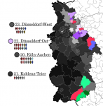
Although the religious divides of the 17th century were still broadly reflected in 20th-century party politics - the Catholic regions voting heavily for the Centre Party, while the Protestant ones mostly voted National Liberal and then increasingly SPD - some change had come to Westphalia since then. In particular, the discovery of huge bituminous coal deposits around the River Ruhr in the 19th century completely upended the economy of the region, giving rise to one of Europe's biggest and most polluted industrial regions. The Ruhrgebiet (as it became known) distinguished itself from its surroundings by the at times extreme poverty present on the workers' estates, as well as the relatively diverse ethnic makeup of the workers - in particular, a large number of Poles migrated to the Ruhrgebiet from the eastern border territories over the years, and made their mark on the region's culture, politics and dialect. Politically, the Ruhrgebiet was a bit of a mixed bag - Dortmund and its surrounds stuck with the SPD, while Essen (not pictured here) tended towards the Centre due to its historic ties to the very Catholic Krupp family, and most of the smaller cities alternated between SPD, Centre and KPD. The provincial borders left the Ruhrgebiet sandwiched between Westphalia and the Rhineland, and with neither side willing to give up their half of Germany's richest industrial area, only minor changes were made to the provincial boundaries as a result of municipal reforms. That was still an ongoing process in 1928, and the specific boundaries on this map were used in no other national election.

Oh, and of course, the northern constituency also included the tiny states of Lippe and Schaumburg-Lippe, both of which fell into the category of "not important enough for Prussia to annex". Lippe having lots of independent cities makes for some interesting results on the map, including our first Nazi plurality in the town of Barntrup (pop. 1,957).

val-de-1928-westf.png
 
Of the provinces lost to Germany in 1945, Silesia was by far the largest and wealthiest. In 1914, it was the second-largest Prussian province after the Rhineland, and Breslau was its third-largest city after Berlin and Köln (although Essen later overtook it owing to municipal restructuring). It was only taken by Prussia in the War of the Austrian Succession, which made it a bit different from the other eastern provinces - notably, it had a large Catholic population, especially in Upper Silesia where a narrow majority of the population spoke Polish. Even the German-speakers in Silesia spoke a highly distinctive regional dialect that took a large number of loanwords from Polish and Czech. After the First World War, Poland laid claim to Upper Silesia citing its large Polish-speaking population, and after three separate Polish uprisings, the League of Nations eventually organised a plebiscite in 1921. The result was an overall majority in favour of staying in Germany, but not as overwhelming as in the East Prussian plebiscites the previous year (largely because Poland wasn't in imminent danger of collapse when the vote was held), and eventually it was agreed to cede a number of border districts to Poland while leaving the majority of the region (including a couple of areas that had voted to join Poland) in German hands.

Lower Silesia had mostly been a liberal region during the German Empire, but the SPD gained the upper hand very quickly after 1918. Breslau in particular went from being a liberal stronghold to an SPD stronghold in a few years, and would switch again to the Nazis as the Depression set in after 1929. The SPD were also buoyed by a strong industrial presence along the foothills of the Sudetes, stretching from Görlitz in the west to the start of Catholic dominance immediately south of Breslau. This stood in contrast to their position in Upper Silesia, where they fell behind the KPD from very early on.

If the Mecklenburg-Pommern WKV was dysfunctional and tended to assign seats unevenly, the Silesian WKV was very highly effective due to being composed of three different constituencies, which meant reaching quota was much, much easier. The Centre Party even got two quotas in the WKV, which led to both Liegnitz and Oppeln receiving surplus seats for the party.

View attachment 46647
Very funny to compare this with post-war Polish voting patterns in the same areas, particularly pre-2005 ones.
 
My assumption would be that the religious voting patterns disappeared completely, while the socioeconomic ones were a lot more consistent than you’d assume.
Partly, but, considering the sort of person who seems to be involved most of the time, I do sort of think German minority activism in the Opole area can be considered a very stunted continuation of the Zentrum tradition
 
Pinging @Makemakean for this one.

The Rhineland was the most populous Prussian province, with some seven million inhabitants as of 1925, and included Köln (Prussia's second city and Germany's fourth) and half of the Ruhrgebiet as well as a large chunk of western Germany alongside its namesake river. This was the heartland (alongside Bavaria) of Catholic Germany, but the legacy of twenty years of French rule meant that it also tended to be quite liberal - it used the Code Napoléon until 1900, and it never took well to the militaristic Protestant conservatism of Prussia. The exception to this pattern is the Bergisches Land, the region around Wuppertal and points south, which was historically an independent duchy and tended to be more religiously and politically mixed than the rest of the province - industrialisation there and in the Ruhrgebiet further contributed to this political diversity.

In 1928, the municipal reforms that created the city of Wuppertal and merged several other municipalities still hadn't been carried out, and so we can see in a bit more detail what the voting patterns looked like. The SPD did well in Elberfeld and Barmen (the two cities that would be merged into Wuppertal in 1929) and Mülheim/Ruhr, while the KPD had some of their biggest strongholds nationally in Solingen, Remscheid and Hamborn (north of Duisburg). Most of the big cities saw the Centre get through over SPD-KPD vote splitting, although the dynamics of this differed from place to place - Essen had been a longstanding Centre stronghold for historic reasons, while in Düsseldorf the KPD came just over a hundred votes from winning a plurality. Köln had a strong SPD, but again not quite strong enough, while Rheydt (the hometown of one Goebbels, J.) had an extremely chaotic split with both the KPD and the DNVP doing quite well.

val-de-1928-rhein.png
 
If the Rhineland was (and is) extremely Catholic, Hessen was for the most part very Protestant. The House of Nassau was, as mentioned previously, traditionally Calvinist, although there was a strong mix of Calvinist, Lutheran and even Catholic congregations in their territory. The same was true of Hessen-Kassel, while Hessen-Darmstadt was officially Lutheran throughout its existence. However, the Lutheran and Reformed churches in all three states were united after the Napoleonic Wars, which made the distinction less significant than it could've been, and Hessen wasn't known to be particularly fervent in its Protestantism.

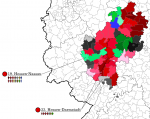
The region around Kassel, as the map shows, was one of the SPD's big strongholds - part of that "Red Triangle" I mentioned earlier - and the industrialised Rhine-Main region tended to support the party as well. The rural areas in between the two were a bit more mixed. During the later years of the German Empire, this was the home of the anti-Semitic political movement, which was essentially a rural populist movement that based its populism on the idea that the Jews were using their position in the financial sector to exploit the common people for their own gain. Nothing particularly creative, but in the 1890s it carried a lot of water, and though the movement itself fell apart after the Great War, its ideas lingered (as evidenced by the later rise of the Nazis, who peddled many of the same ideas). The most obvious political heirs of the anti-Semites were probably the CNBL, who had a particular stronghold in Oberhessen (the detached northern part of Hessen-Darmstadt) and additional pockets of strength throughout the state. Lastly, of course, there were a few Catholic areas within Hessen, particularly the area around Fulda (formerly a self-governing abbey) and the Westerwald (formerly part of the Archbishopric of Trier) - these areas, of course, voted for the Centre.

val-de-1928-hessen.png
 
Lower Saxony turns out to be surprisingly interesting, because while the river mouths and the region around Hannover were and are very strong for the SPD (the Hannover South-Braunschweig constituency was their strongest nationwide in 1928), the rural parts of it were a lot more politically diverse. The Emsland and surrounding regions had been part of the Bishopric of Münster, and even today they're strongholds for the CDU - in 1928, the Centre vote here was pretty much monolithic. The rural part of Oldenburg turns out to have been big into the Nazis even this early, with several districts returning pluralities for them, but this wasn't enough to get them a seat in the Weser-Ems constituency - they got one in the WKV, which was assigned to Hannover due to the surplus there being bigger.

Across the north and east of Hannover Province, meanwhile, the major party of the right was the Deutsch-Hannoversche Partei - also known as the Welfenpartei for short - which advocated for the restoration of Hannover as a state in its own right, and formerly also the restoration of the House of Welf to its throne (from which they'd been pretty unceremoniously deposed and their property seized under Bismarck - I suspect this was why the restoration movement flourished in Hannover and not elsewhere). I don't know how gung-ho they were about the monarchism part after WWI, but I do know they were ideologically pretty close to the DNVP, so it's quite possible that they carried it on. Anyway, in 1928 the DHP was in an electoral alliance with the CNBL - or at least their results are presented together in the report I'm using, although their WKV seats were calculated separately, so I don't really know what the hell was up. I've depicted them as one party on the map, however, and that means quite a lot of the province has likely ended up greener than it otherwise would've.

The amount of green on the map generally is turning out to be a lot more than I would've guessed, and that's not likely to stop - our next destination is Bayern, where the farmers' movement was the main opposition party in some areas.

val-de-1928-ni.png
 
To go with that, here's a map of all of Northern Germany:

val-de-1928-ny.png
 
I don't know how gung-ho they were about the monarchism part after WWI, but I do know they were ideologically pretty close to the DNVP, so it's quite possible that they carried it on.

Got to admit, for that one Vignette I did on the idea, I basically went with 'probably not all that interested for the most part given normal circumstances, but would back it if the situation seemed appropriate.'

Whereas, of course, down in Bayern it was a much more serious thing.
 
Not to pass over the regional overviews for Southern Germany, here's the largest state after Prussia and the only other one to have more than one WKV: it's Bavaria. Which, before WWII, also included the left-bank Rhenish Palatinate for obscure reasons to do with the region being the original homeland of the Wittelsbachs and Bavaria wanting compensation after the Napoleonic Wars.

Today it's very easy to think of Bavaria as a cultural unit, being very Catholic, very conservative and very much a one-party state, but this was a lot less true in 1928. For a start, the Bavarian wing of political Catholicism was a lot more right-wing than elsewhere in Germany, standing in contrast to the Rhineland's more liberal bent in particular, and so in 1919 the Bavarian branch of the Centre Party split off to create their own party (blackjack and hookers presumably being optional), creatively dubbed the Bayerische Volkspartei or Bavarian People's Party. As @Alex Richards mentioned upthread, this party included outright Wittelsbach restorationists as well as general Catholic conservatives, and in general tended to be seen as the party of the regional establishment rather than the more "underdog" perspective of the Centre in Prussia. Which in turn meant that, ironically given post-war history, the BVP's hold on power in Bavaria proper was a lot more fickle than it was in most other parts of Catholic Germany. They were opposed by the SPD in the cities - the SPD did pretty well across the state in 1928, winning basically every major city as well as a fair few industrial towns - and in the countryside by the Bayerischer Bauernbund, which differed from most of the German agrarian movement by not being nationalistic anti-Semitic weirdos, and instead building their populism on anticlerical and anti-noble sentiment.

You might argue that Bavaria before the war looked a lot more like your typical majority-Catholic country, with a clerical/anti-clerical and establishment/anti-establishment divide playing a more significant role than Catholic identity as such. But of course, this was only true of Bavaria proper - the regions added to the state during and after the Napoleonic Wars, which included Franken as well as the Palatinate, were a lot closer to the baseline for Catholic Germany. Mittelfranken, with its strong Protestant and Hohenzollern heritage, voted pretty overwhelmingly for the DNVP - in fact, the DNVP had been the strongest party in the region in two previous elections, although the SPD edged them out in 1928 due to their strong support in the cities. The same sort of urban/rural split, but with the BVP as the rural party instead of the DNVP, prevailed in the rest of "new Bavaria", which means that for all intents and purposes (and ignoring the Nazi interlude), the region's party politics barely changed from 1928 to 1968.

val-de-1928-by.png
 
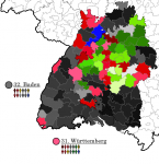
Baden and Württemberg were, of course, still separate states in 1928. They were very culturally different, too, with Württemberg being almost entirely Swabian and Baden being split between Franconian/Palatine dialects in the north and Alemannic ones in the south, united by a shared distrust of all things Swabian. Württemberg was also majority Protestant, while Baden was majority Catholic despite its former monarchs having been Protestant as well - that said, Baden was decidedly on the liberal side of German Catholicism, and in general always took heavy inspiration from France. This included being the only state of the Weimar Republic to formally use the style Republik rather than Freistaat or Volksstaat (which was the style used by Württemberg), and on top of that they had a Swiss-style collegial executive with a rotating presidency. I think those factors combined make Baden the most fun German state in this time period, and of course it doesn't hurt that it was one of the states where the Weimar Coalition stayed in power right up until the Nazis took over.

In general, Baden followed the same pattern as Franken, with the SPD doing well in the cities and the Centre dominating most of the countryside (with the exception of two districts bordering Württemberg which, if I had to guess, I'd say were probably majority Protestant, and which voted for the DNVP). Württemberg, however, was a bit strange. It, too, had a strong urban SPD, but the countryside was very much split along religious lines between the Centre, which prevailed in the Catholic regions in the south and east, and the (copy-pastes from Wikipedia) Württembergischer Bauern- und Weingärtnerbund (Württembergish Farmers' and Vintners' Association) which were the major right-wing party in Protestant Württemberg. Unlike its Bavarian counterpart, the WBWB was firmly on the right of the political spectrum, having a history of close cooperation with the DNVP and their predecessor parties. And although the regional divide meant that the SPD came out on top in Württemberg in 1928, the state tended on the whole to be less left-leaning than Baden - from 1924 onwards, it was run by a coalition of the Centre and DNVP with support from the WBWB.

val-de-1928-bw.png
 
Awesome maps and writeups as always, @Ares96 !

Have to say, even knowing a little about the winemaking history of southern Germany, there is something quaint about putting "vintners'" in the party name. Can't have people thinking it's just peasants, now can we?

Bayerischer Bauernbund, which differed from most of the German agrarian movement by not being nationalistic anti-Semitic weirdos
German interwar politics: where it is legitimately necessary to add this qualifier...
 
Ah I was wondering if we’d have in-depth looks at southern Germany and glad you did write them.

Could we expect some state election results as well? Or this is this all we’re getting for some time?
 
Back
Top