• Hi Guest!

    The costs of running this forum are covered by Sea Lion Press. If you'd like to help support the company and the forum, visit patreon.com/sealionpress

Max's election maps and assorted others

I strongly oppose the translation of fasci into league. It's much more fun when you translate it as sheaf or bundle.
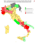
 
Italy 1919 (pop)
So while the Italian electoral system of 1919 was a pretty good one by their standards and by the standards of the time (if only because it was relatively simple), it was by no means perfect. In particular, the apportionment of seats between the constituencies did not follow population, but rather was determined by how many single-member constituencies there'd been in each province before. Now, those were fairly closely attuned to population figures when they were drawn up... in 1892. Yeah.

Calculating the seat apportionment with a regular Hare-quota largest-remainder method (which is how most countries do it AFAIK), then, basically gives us a map of population change from 1892 to 1911 (which is when the population figures cited in the 1919 results document are from - guessing they didn't have a lot of time for a new census in the time between, what with the world war and all). Which is itself sort of interesting. Obviously, the major cities are underrepresented - Milan, then as now Italy's biggest industrial centre, is owed a whopping five seats compared to its OTL allocation. It's only the second most underrepresented constituency in terms of population per deputy, though, narrowly being edged out by Rome. The latter was not actually a very large city when it was made the capital of Italy in 1871, but a combination of government jobs, policies encouraging urban growth and massive rural poverty across Italy in this period ensured that it grew like a sponge, tripling in population between 1871 and 1921.

That rural crisis is also sort of visible, but interestingly, it mostly shows up in two specific traditionally agricultural regions - Piedmont and Campania. All provinces in the former, and all but Naples in the latter, were overrepresented by 1919. This includes Turin, which, even though its seat was one of Italy's biggest cities, also included a lot of rural areas that were not doing great at this point. The most overrepresented province, however, was Potenza, which was owed about seven seats but had ten. On the opposite end of the spectrum, Apulia, eastern Sicily and large parts of the northeast were actually underrepresented slightly, despite essentially being rural (although some provinces, like Bari or Brescia, had a significant industrial presence).

val-it-1919-pop.png

So what does this tell us about the election results? Well, recalculating the results of all over- or underrepresented constituencies is not something I'm keen on right now, but at a cursory glance, the five seats owed to Milan would probably mostly go to the PSI, with some to the PPI and Liberals. Bergamo and Brescia were both huge PPI strongholds, while Udine and Venice were somewhat evenly split between PPI and PSI. Rome was evenly split between the PSI, PPI and the "old left" bloc, while Naples was a stronghold of the latter, as (for the most part) were Apulia and eastern Sicily. Most of the underrepresented constituencies in the north (all but Cuneo, in fact) were PSI strongholds, while all the ones in the south were won by the old left. So most likely, the old left would be the main losers out of this - which makes sense considering they mostly based their support on rural patronage networks, and most of the overrepresented constituencies were rural. It's a bit harder to get a feel for which parties would gain, but the PSI would probably break even or even lose out slightly, while the PPI might make small gains.
 
Brisbane trams (1961)
I did a thing.

brisbane-tram.png
 
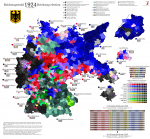
Reichstagswahl 1919
(Yes, I know the threadmark is wrong, shut up)

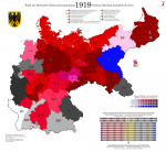
So I moved the old 1919 map to the new base. I don't actually have results at lower levels (and I'm not sure they exist - @Erinthecute may correct me if I'm wrong), so this is not actually adding any new information, but still, it looks a bit cleaner and it makes comparison with the later maps easier.

val-de-1919-ny.png
 
Last edited:
I don't actually have results at lower levels (and I'm not sure they exist - @Erinthecute may correct me if I'm wrong)

The book I read gave results by Imperial Reichstagswahlkreis, but it's implied that the author had access to more granular results (by district, usually, though not for everywhere). In the bibliography he cites the Reich Office for Staistics and the quarterly statisical report:

STATISTISCHES REICHSAMT: Die Wahlen zur verfassunggebenden Deutschen Nationalversammlung am 19. Januar 1919 mit einer Karte der Wahlkreise und farbiger Darstellung der Zahl und Parteistellung der in jedem Wahlkreis gewählten Abgeordneten (= Vierteljahreshefte zur Statistik des Deutschen Reichs – 28. Jg., 1919, Erstes Ergänzungsheft), Berlin 1919.

DASS. (Hrsg.): Vierteljahreshefte zur Statistik des Deutschen Reichs, 28. Jg. 1919, Viertes Heft.
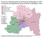
 
Santiago 1970 (org)
Here's a quick late-night project. Five years ago now (yes, five years), I made some maps of Chile in the 1960s and 70s, but I was never quite pleased with those - in particular, I could never figure out how the area around Santiago was organised. I was pretty sure the mess of tiny municipalities the city is divided into today weren't there then, but even ignoring that, Pinochet's administrative reforms meant that the basic shapes of the old administrative units often weren't available. At the time, instead of the regions and provinces of today, Chile was divided into 25 larger provinces (provincias), many of which were equivalent to today's regions, and a number of departments (departamentos) below that. Wikipedia has no good map of the latter, their provincial maps are all from the 1910s, and the only thing I learned by googling it was that departamento is also the Chilean Spanish word for "apartment".

I've since learned a bit more about online archival research, but there's still huge problems finding anything good from this period - stuff that's new enough to feasibly be under copyright but old enough to have been created on paper through entirely analogue methods is usually hard to find digitised, and this was no exception. Looking it up in the National Library of Chile's online database, I found a relatively decent map of the 25 provinces from 1967, which will no doubt help with adjustments of the main map but provides little help for Santiago. A few searches later and I found this, which I believe is a map of mineral resources (my Spanish is not great) but which also includes municipal boundaries as of 1970 - eureka. Only one small problem - even though they've clearly scanned it and put up a preview on the website, the full map has not been made available (rights issues?). I don't really have the budget to go to Santiago and check it out, so I did the best I could using it and the information on Wikipedia.

santiago-1973.png

When the Province of Santiago was reorganised in 1927, three departments were created: Melipilla, which covered the municipalities along the coast and in the coastal ranges of the province's southwest, Maipo, which covered a small area south of the Maipo River that had previously formed part of O'Higgins Province, and Santiago, which covered the entire rest of the province. This was basically fine at the time - the 1927 municipal reform also expanded the city of Santiago to cover most of its then-urban area, actually making it substantially bigger than it is today, so there wasn't much need for the department to coordinate governance across suburbs or anything like that. However, 1927 was also the beginning of a long period of urbanisation, and Santiago would grow prodigiously over the next few decades (even up to today, although I believe it's starting to taper off).

This meant that the Santiago department would eventually need to be split, but at least to begin with, this was mainly to separate out rural areas from the city. In 1937, San Bernardo was raised to department status, followed by Talagante in 1940 - both areas bordered the other departments, the northern and eastern areas remaining part of the Santiago department. The southeast was eventually split off in 1958, forming the new department of Puente Alto, which also took over Pirque from the Maipo department and reduced it to an even smaller area. In 1963, finally, some of the southern suburbs were split off into a new department named after the popular former president Pedro Aguirre Cerda, who had died in office of TB in 1941. This left the Santiago department controlling most of the suburbs (all but the southern zone) as well as the northern rural areas of the province. When Pinochet raised the departments to provinces and the provinces to regions in 1976, the latter were split off as the new province of Chacabuco, but the province of Santiago still covers the bulk of the urban area.

(The municipalities west of the coastal ranges were also split off into the new department of San Antonio in 1933, but since that was moved into the Valparaíso region by the aforementioned 1976 administrative reform, it's not on my basemap and thus not on this - sorry about that)

As far as I've been able to tell, the municipal boundaries were surprisingly stable during this period. It wouldn't surprise me if there had been a fair few boundary adjustments, but the new municipalities created between 1927 and 1973 were all in the eastern suburbs of Santiago itself. Providencia saw its rural areas split off in 1932 to create Las Condes, while Ñuñoa saw La Florida split off in 1934 and La Reina in 1963, still leaving it significantly bigger than it is currently. And in 1939, La Cisterna was split in half to create La Granja - both of which were bigger then than now, though not by much. Santiago proper still covered quite a few suburban areas, and would continue to do so until 1981, when it was reduced to its old urban core by another one of Pinochet's territorial reforms.

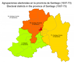
santiago-1973-el.png

Initially, the province was divided into two electoral districts: district 7, which covered the department of Santiago, and district 8, which covered the rest of the province. To account for its growing population, as well as the disparity of interests between the city and the rural areas around it, district 7 was split into three parts for the 1932 election, with the city forming district 7A all by itself while the remainder of the department was divided west-east into districts 7B and 7C. These were reorganised slightly in 1937, when San Bernardo was detached from whichever one of 7B or 7C it had been part of previously and attached to 8, and possibly saw another small border change when Pirque switched from Maipo to Santiago/Puente Alto - I'm not sure when exactly that happened or whether the electoral map was adjusted to take this into account. What I do know is that after 1937, there was no reapportionment of seats among these districts (or, I think, anywhere in Chile except the far south, which had a few seats added in the 60s). In 1973, district 7A recorded 392,033 votes, while 7B had 324,115 and 7C 573,170, and yet the seat apportionment was the same as it had been for over thirty years. Clearly some sort of change was going to become necessary as the city kept growing, but for obvious reasons, it would take another good while before any such change came.
 
1883 statistical atlas (including political maps), printed when this bloke was eight years old, and that's not the earliest either. There's a non-political one from the year before he was born, and I think the French may have got before that too.

It's got Democrats in red and Republicans in blue. Buuuh!

Most counties in the South are Democratic, while most counties in the North are Republican. Though what is interesting is how there really doesn't appear to be a rural-urban divide in the North. If I ever get around to doing that machine learning project of mine, it would be interesting to try to get a more granular look at who voted Republican and who voted Democratic in the North in the era between Lincoln and FDR.
 
Most counties in the South are Democratic, while most counties in the North are Republican. Though what is interesting is how there really doesn't appear to be a rural-urban divide in the North. If I ever get around to doing that machine learning project of mine, it would be interesting to try to get a more granular look at who voted Republican and who voted Democratic in the North in the era between Lincoln and FDR.
You can basically define the cultural divide between North and South in the US (not quite the same as Union vs CSA) by looking at the county voting patterns in that period, rather than the other way around - it cuts across Illinois, Indiana and Ohio for instance. Urban-rural divides were much less apparent then, e.g. Chicago or Philadelphia could vote Republican, or more accurately, one side might vote Republican and one side vote Democratic based on demographics.

The obvious Northern Democratic constituency was Catholics, as well as (later on) anti-temperance people who opposed 'dry' laws (hence "party of Rum, Romanism, and Rebellion"). It's worth noting that while race and creed based voting blocs may sound dismissively monolithic (as indeed they still do in modern US political discourse!) they could still shift significantly based on issues. In a similar way to how Mormons opposed Trump in 2016 and 2020, Northern German-speakers in places like Wisconsin turned sharply against the Republicans in the 1890 midterms because Republican state governments had been pushing English-only language laws.

Apologies to @Ares96 for derailing his thread slightly.
 
Reichstagswahl 1924/I
Next up is May 1924, the election so nice they held it twice - first they redid one constituency in September, and then in December, the entire thing. Again, a crosspost of the old DA description:

The parliamentary impasse created by the 1920 elections was solved, three weeks after the elections, by the appointment of a centre-right minority government, led by the Centre's Constantin Fehrenbach (who had been President of the old Reichstag and then the National Assembly) and consisting of Centre, DVP and DDP. The SPD chose to go into opposition, but supported the government tactically so as to maintain the republican front. Benefits were modestly increased during Fehrenbach's eleven months as Chancellor, but he would focus above all on foreign affairs, as Germany and the world settled into its post-war reality.

Chancellor Fehrenbach travelled to Spa in July 1920 to meet with David Lloyd George and Alexandre Millerand and, hopefully, work out a satisfactory repayment plan for the enormous war reparations stipulated in the Treaty of Versailles. The Spa Conference came to no definite conclusion on the size of reparations, but set proportions for payments to each of the Allied Powers, and required Germany to deliver five million tons of coal a month to the Allies for six months. Though the Allies promised to pay for the coal, the take was less than it would've been if sold commercially, and the shipments deprived German industries of fuel. There immediately arose tensions within the government over how to deal with the situation, with the still right-wing DVP urging a more confrontational line, and this eventually caused the fall of the Fehrenbach ministry in May 1921. It was replaced by a centre-left coalition of Centre, DDP and SPD, led by the more left-leaning Centrist Joseph Wirth, who had been Finance Minister in Fehrenbach's cabinet.

By then, the collapse of the German economy had begun in earnest. Terms for the payment of reparations and war debt (Germany having funded its war effort almost entirely through borrowing) were finally set by the Allies in April, and Germany made its first payment on schedule in June. The currency markets reacted about as well as you'd expect to the sudden disappearance of two billion 1914 marks from the economy, and the German currency entered its infamous inflationary death spiral. By the end of 1921, one US dollar was worth 330 marks. By the end of 1922, the figure was 7,200, and by November 1923, four trillion (we'll get to the details of that second crash later on). The government paying its reparations by printing paper money and using it to buy foreign currency did not help matters.

Wirth's strategy was to make an earnest attempt to comply with Allied demands, and thus demonstrate that actually following them would be a financial impossibility. However, almost everyone to his right was convinced he was really no more than a cypher for the Allies, and calls for his assassination went up by the day. In August, former Finance Minister and current informal government adviser Matthias Erzberger was killed while holidaying in the Black Forest. His assassins were right-wing nationalists who viewed him as a traitor for having signed the Versailles Treaty, and escaped to Hungary before they could face justice. Erzberger's funeral became a pro-republican political rally, with thousands in attendance and Chancellor Wirth delivering the eulogy.

Meanwhile, the government had come to the realisation that there was one foreign power that wasn't bound by the Allied diplomatic conventions and might be amenable to trade - Soviet Russia. After an international conference in Genoa in April 1922 ended in failure, German and Soviet representatives travelled to Rapallo, a short way down the coast from Genoa, and signed a treaty of friendship there. The two countries agreed to renounce all claims on each other's territory, to establish a firm peace based on equality and mutual goodwill, and to resume trade. The Treaty of Rapallo also included secret clauses establishing military cooperation between the Red Army and the rump Reichswehr, although these were publicly denied at the time.

The German foreign minister responsible for negotiating the treaty was Walther Rathenau, an engineer, businessman and billionaire who was the head of the AEG sphere, which included as many as 84 different companies located across the globe. Rathenau was also Jewish, and even though he was a moderate liberal by inclination who only happened to see Realpolitik benefits to aligning with the Soviets, the right naturally saw the Treaty of Rapallo as the first blast of the trumpet in the Judaeo-Bolshevik takeover of the German nation. Two months after the treaty was signed, Rathenau was riding a car from his home to the ministry when one of the passengers in a passing car opened fire with a submachine gun. It was the second assassination of a prominent democratic politician by right-wing extremists in less than a year, and it soon transpired that the same organisation was responsible for both Erzberger's and Rathenau's deaths. Organisation Consul, a death squad made up of former Freikorps soldiers, was in fact responsible for at least 354 murders since the end of the War. When the Reichstag convened the following day, Wirth made the most famous speech of his career: "There stands the enemy, who trickles poison in the wounds of a nation. There stands the enemy - and there is no doubt about it - the enemy stands on the right!"

A law banning the O.C. (don't call it that) was passed within a month, but the death of Rathenau and the ensuing nationwide panic had caused renewed government instability. Wirth's recipe for ending this crisis was to attempt to bring all democratic parties together into a grand coalition, but his efforts met with no success, and he finally resigned the chancellorship in November 1922. President Ebert, hoping to achieve national unity by different means, replaced Wirth's government with a technocratic ministry chaired by HAPAG director Wilhelm Cuno. It was hoped that Cuno, as a shipping magnate with good connections in London and New York, would be in a unique position to sort out Germany's foreign policy issues, but this was too much to bargain for. Cuno's proposed repayment plan was vetoed by the French, and when Germany fell behind on coal shipments, the Allies invoked the enforcement clauses in the Treaty of Versailles and occupied the Ruhr Area.

The occupation of the Ruhr would last more than two and a half years, from January 1923 through to August 1925. It was a provocation the German government could not allow to stand unanswered, and though no one had any desire to restart the War, the locals were urged to passively resist the occupation authorities. The occupation and the resultant protests would result in around 130 German civilian deaths, and the economy of the Ruhr Area, Germany's largest industrial engine, came to a near-complete halt. Again, the mark entered a cycle of inflation, this time the worst ever seen in the history of the world. By the autumn of 1923, basic commodities cost billions or trillions of marks, and banknotes were being used as cheap wallpaper. Savings vanished overnight, and there seemed to be no way to salvage the collapsing currency. The French government refused to treat with German representatives unless passive resistance was ended, which left Cuno with precious few options. In August, a series of wildcat strikes erupted calling for Cuno's resignation, and for a brief moment it seemed as though Germany was heading toward a general strike. That motion was quashed, however, by the SPD leadership, which was convinced the crisis needed to be solved by parliamentary means or else there might be another revolutionary crisis. A vote of confidence was tabled in the Reichstag on the 12th of August, which passed easily, and Cuno left office, his technocratic experiment a dismal failure.

This time, efforts to bring about a grand coalition were successful, and the DVP's Gustav Stresemann (a monarchist at heart, like most of his party, but a tacit supporter of the republican front as a guardian of German democracy) became Chancellor with a broad majority in the Reichstag. The new government immediately set about resolving the crises facing Germany one by one. The strikes of August were resolved through the creation of a binding arbitration system, which passed the Reichstag with broad support in early October. Passive resistance to the Ruhr occupation was dropped as an official policy in September, and President Ebert signed a declaration of emergency that broadened the government's powers in domestic affairs greatly (though not as greatly as the laws allowed - more on that in later instalments...). Hyperinflation was solved through the introduction of a new currency, the Rentenmark ("mortgage mark"), which was backed by government bonds that were in turn index-linked to the price of gold. Twelve zeroes were cut from prices, and the new mark proved reasonably stable.

Most notably, Stresemann initiated talks with the French, the British and the Americans, of which the latter two were far more favourably inclined to the German perspective now than they had been in 1919. By the time those talks came to fruition, Stresemann's chancellorship was over - the strikes in August that had brought down Cuno were the end for the SPD, but only the beginning for those on their left. In October, the Comintern adopted a plan of action to bring down the "bourgeois" Weimar Republic and replace it with a communist state, and in October, the state elections in Saxony saw the KPD enter government on the state level for the first time ever, as the SPD's junior coalition partner. Stresemann smelled a rat, and using the emergency powers vested in him by President Ebert, he ordered the Saxon government dismissed from office and the state placed under commissioners' rule. This decision caused the SPD to abandon the Stresemann government and go into opposition, and that in turn sealed Stresemann's fate. As soon as the Reichstag reconvened, a motion of confidence was tabled, and failed - technically, this did not force Stresemann's resignation, but he still left office rather than try to cling on. In the new cabinet, a centre-right minority government similar to the Fehrenbach cabinet, Stresemann accepted the position of Foreign Minister, which allowed him to carry on treating with the French into 1924.

The new Chancellor was Wilhelm Marx, a Centrist of the old school who, contrary to what his name would imply, was no great friend of the left. His government was focused on ending the crisis and restoring Germany's financial stability, and to this end, the highly controversial Lex Emminger was promulgated over the opposition of the Reichstag, abolishing jury trials and replacing the former twelve-member juries with panels consisting of three judges and six lay judges. This was presented as a cost-saving measure, and faced stiff opposition from the legal profession as well as the left, but it remains the foundation of the German judiciary to this day.

There was little else Marx had time to do before the general election was due. The Reichstag's term was set to expire in June, but Marx's government decided to call the election for the 4th of May. The campaign was every bit as spirited as that of 1920, and saw the government attacked from both left and right, the KPD invoking the dismissal of the Saxon government as a sign that Germany was sliding toward fascism while the DNVP invoked the Rapallo Treaty, the French troops still in the Ruhr and the ongoing negotiations as signs that Germany was sliding into a position of servitude to foreign powers.

The election result saw a massive rightward shift, as the KPD failed to capture the support of the former USPD (which had merged back into the SPD in late 1922) while the DNVP grew hugely, mostly off of DVP voters who resented their party's turn to constructive engagement with the hated republic. The DNVP remained the clear right-wing opposition, but new forces also entered the Reichstag. In November of 1923, a disaffected former soldier named Adolf Hitler gathered around two thousand followers and attempted to overthrow the Bavarian state government, using Mussolini's march on Rome as a blueprint and acting with the blessing of the former army commander Erich Ludendorff. The "Hitler-Ludendorff-Putsch", which was soon rechristened the Beer Hall Putsch by the foreign press, saw sixteen insurgents killed by police as order was restored, and Hitler himself was captured and imprisoned for treason. The trial of Hitler created a martyr for the extreme right, and a coalition of Hitler's NSDAP (temporarily banned after the putsch), Ludendorff's supporters in the völkisch movement and some right-wing splinters off the DNVP cobbled together a Reichstag candidacy under the name of the "National Socialist Freedom Movement". This managed to gain 32 seats in the new Reichstag, which along with the DNVP and KPD factions meant that even the broad coalition led by Stresemann would've enjoyed no more than a threadbare majority.

Though the situation was less dire than in 1920, there were still French troops in the Ruhr and the reparations issue was still unsolved. Germany's troubles would continue...
This is the last one I have one of these writeups for, so next time I'm going to have to do it from scratch.

One thing that's worth noting is that this election is an example of the de facto electoral threshold in the Weimar electoral law: although the basic rule was one seat per 60k votes, there was also a provision that no party's Reichswahlvorschlag could receive more seats than its connected Kreiswahlvorschläge had gotten on the constituency level. So although the USPD remnant got enough votes for four seats nationwide, those votes were spread out fairly evenly across the country, and weren't enough to get a constituency seat anywhere. As a result, the party got no seats on the national level either. Both the DSP and the WP were also hurt by this, although the WP's alliance with the BBB meant they got at least one seat more than they would have if they formed an RWV by themselves.

val-de-1924-i-ny.png
 
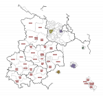
Here's a preview of one of the most pointless election maps I've ever made. I've previously done the 1990 Volkskammer election, the only one in the history of that institution where the votes cast actually mattered, and until now I'd assumed that the previous iterations were all elected through a single nationwide list. Not so, as it turns out - as in Poland, the GDR was divided into small-ish constituencies that elected between four and thirteen (though usually between six and ten) members. Each constituency's local representatives were supposedly selected through an open process, though the fact that the seat distribution between the different National Front parties was determined in advance makes me seriously question how open that process really was. Anyway, these constituencies seem to have been the same at least between 1963 (the earliest ordinance I can find - the 1954 electoral law mentions that each constituency should elect 10-20 members, so I've got some reason to suspect they were bigger at that time) and 1986, the last "single-party" election. The below map shows the constituencies in those regions where I'd previously finished drawing the municipal map, plus East Berlin (which only voted in 1981 and 1986 - it had representatives in the Volkskammer before then, but much like the West Berlin representatives in the Bundestag, they were indirectly elected to avoid upsetting Berlin's weird legal status). For obvious reasons, majority shading would be a bit redundant, and none of the membership lists I've found show which constituency each member represented, so this is really as much as I can do with this information.

val-ddr-1986.png
 
Here's a preview of one of the most pointless election maps I've ever made. I've previously done the 1990 Volkskammer election, the only one in the history of that institution where the votes cast actually mattered, and until now I'd assumed that the previous iterations were all elected through a single nationwide list. Not so, as it turns out - as in Poland, the GDR was divided into small-ish constituencies that elected between four and thirteen (though usually between six and ten) members. Each constituency's local representatives were supposedly selected through an open process, though the fact that the seat distribution between the different National Front parties was determined in advance makes me seriously question how open that process really was. Anyway, these constituencies seem to have been the same at least between 1963 (the earliest ordinance I can find - the 1954 electoral law mentions that each constituency should elect 10-20 members, so I've got some reason to suspect they were bigger at that time) and 1986, the last "single-party" election. The below map shows the constituencies in those regions where I'd previously finished drawing the municipal map, plus East Berlin (which only voted in 1981 and 1986 - it had representatives in the Volkskammer before then, but much like the West Berlin representatives in the Bundestag, they were indirectly elected to avoid upsetting Berlin's weird legal status). For obvious reasons, majority shading would be a bit redundant, and none of the membership lists I've found show which constituency each member represented, so this is really as much as I can do with this information.

View attachment 59148
Definite same energy as all those US state legislatures which go to all the trouble to draw districts which nobody ever contests anyway.
 
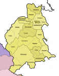
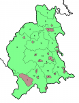
And an update to the Austrian map, which I realise I haven't touched in months. However, I was at long last able to cobble together the districts of the Bukovina. Worth noting these boundaries aren't quite as set in stone as some of the others, but I've done plenty of conjecture on other areas as well, so I don't expect it to be notably worse than those either.

bukowina-bezirke.png

(I am not posting the entire thing, since it's not connected geographically to any of the other parts of Cisleithania I've done)

The Bukovina, today, straddles the Romanian-Ukrainian border, but it was originally all part of the Principality of Moldavia, which fell under Ottoman sway for most of the early modern period but continued to be ruled by the local Orthodox Romanian-speaking boyar families. In 1775, as part of a peace treaty between Austria and the Ottomans, the Bukovina was lopped off and handed to Austria because Maria Theresa wanted a road built between the newly-acquired Galicia and Hungary, and none of the mountain passes previously inside Austrian borders were deemed good enough for this purpose. Given the unceremonious origins of the province, its small size and the long distance to Vienna, it shouldn't come as a surprise that it was one of the poorest and most underdeveloped regions of the entire empire. And while neighbouring Galicia (which I'm getting to, I promise, but it's big and sources are scarce) had a strong local elite in the form of the Polish szlachta, who dominated its politics and lent it some stability even though they were challenged by the Ruthenian and Jewish minorities, the Bukovina was a free-for-all with Romanians and Ruthenians about equally numerous and equally poor, while the German elite was too small to exert anything resembling dominance. When the Bukovina Landtag was reformed in 1910, the electoral system created for it was said to be the most complex in Europe, with five different curiae and five different ethnic groups guaranteed representation in the two lowermost curiae (municipal councils and the universal male franchise), in addition to reserved seats for the Church in the landowner curia and probably any number of other stupid details.

bukowina-wahlbezirke.png

We're lucky that the equivalent system was abolished for Reichsrat elections in 1907, but even the post-1907 constituencies in the Bukovina were quite strange. While three of the four urban constituencies made a reasonable amount of sense, the fourth one seems to have mostly been made up of random villages - the fact that many of them have a "Deutsch-" at the start of their name tells me that this constituency was more about ethnic gerrymandering than urban representation, and so does its relatively small electorate (although it was about level with seat 3). The rural seats were somewhat more reasonable, but constituencies 6 and 11 simply cannot have both been contiguous, and as the map indicates, I have a strong suspicion constituency 9 had at least one exclave inside constituency 8's territory. Part of me wonders if this was another ethnic stitch-up - as we've seen, there were plenty of those to go around - but I don't know for sure, and it would be a very strange ethnic border if so.

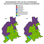
bukowina-1907.png

The elections weren't terribly exciting in and of themselves - the rural constituencies were represented by whatever the dominant ethnic group was, and neither one was big enough to develop distinct political tendencies. The two smaller urban seats were represented by Germans - constituency 4 by an Agrarian, which pretty much fully convinces me that the "urban" nature of that seat was a pure fig leaf, while constituency 3 actually switched from a German National (well, a German Progressive - I sometimes wonder if I should try to separate out the different German nationalist parties, but I suspect that would be too much even for this). Czernowitz was a bit more interesting, though, and its two constituencies reveal the very particular mix of ethnicities present in the town. Constituency 2, covering the western half of it, was represented by the Romanian social democrat Gheorghe Grigorovici (separating out the different stripes of social democrat is another thing I've been wondering about but ended up leaning against, and Grigorovici sat with the German social democrats anyway), while constituency 1 elected Benno Straucher, the leader of the local Jewish community, who is labelled a "Zionist" in period sources even though he was by all accounts more of a pragmatic assimilationist. He was one of four Jews elected to the 1907 Reichsrat in their capacity as Jewish community representatives, the other three all being in Galicia, and the only one to keep his seat in 1911.
 
Back
Top