
Yemina as wellVote-splitting between Likud and the ultra-Orthodox parties?

-
Hi Guest!
The costs of running this forum are covered by Sea Lion Press. If you'd like to help support the company and the forum, visit patreon.com/sealionpress
You are using an out of date browser. It may not display this or other websites correctly.
You should upgrade or use an alternative browser.
You should upgrade or use an alternative browser.
Lavidor's maps and projects
- Thread starter Lavidor
- Start date
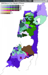
Now the Nazareth area:


Nazareth is the largest Arab city in Israel, it voted 96% Joint List and even higher in some of the suburbs.
Afula is a classic "development town" hence Likud-voting (probable representative: Ofir Katz) although I had to include some nearby villages to make up the numbers.
Nof HaGalil is similar in profile to Lydda North - Likud in 1st, Joint List in 2nd, Beitenu 3rd, theoretically but not practically strong for the opposition bloc.
Sepphoris (the northwest one) is a potentially interesting seat - Joint List and the Zionist left are pretty evenly matched, there's a Bedouin population which could provide a crucial swing vote (Galilee Bedouin traditionally are more accepting of Zionism, some serve in the army, and their vote is much less monolithic than in Arab cities and towns).
Haifa area, check out my hawt quadripoints.


Not totally pleased with the Krayot seats - the concept is that the bulk of each municipality forms a seat, and the outer ends form another, linked by Route 79. But in practice there are some weird salients and Kiryat Bialik is still slightly under quota.
I thought I knew Haifa well, but there were some surprises - the results show that very few of the city's elite live in Hadar, the old uptown core. Turnout is 40% which I think means the population figures include former residents who left the country. The party of elites (Blue-White) gets nowhere here, the largest party in the core neighbourhood is Joint List but the Haredi community in East Hadar had high turnout making UTJ bigger in the whole seat and pushing the Netanyahu bloc slightly ahead.
Clearly the elite moved further uptown, to the height of Mount Carmel, providing 2 ultrasafe Blue-White seats. Although maybe they left the city altogether, there is a lot of emigration. Anecdotally, former mayor and Labour leader Amram Mitzna lives in Tel Aviv now.
Likud has its classic strongholds, Tirat Carmel, Kiryat Yam, Kiryat Haim West, and the old part of Kiryat Ata, also Neve Shaanan although that neighbourhood isn't big enough to make the seat safe. The other suburbs actually look like they trended against Likud / had a smaller swing than the country but I haven't gone into detail.
Downtown predictably gives a seat to the Joint List - I would guess for Ayman Odeh although like most Ahmadis he lives in Kababir, which I've put in the Stella Maris seat.
And closing out the North.


This seems like a nice spot for an interim summary. So far I've mapped 129 out of 199 constituencies.
The 2020 results in this system so far, counting bloc parties together, yield 72 seats for Netanyahu and 57 seats for Gantz. Things seem well on track for an extremely tight final result, though tilting to Netanyahu. 100-99 or 101-98 if I guess the outstanding seats right.
In terms of largest parties: Blue-White won the most votes in 27 seats so far.
Likud was largest in 67 seats, UTJ in 11, Shas 1, Yemina 1. Netanyahu by instinct would almost certainly run a joint slate with the Haredi parties and some defectors while trying to freeze out Bennet, so imagine Shas bigger at Likud's expense.
The Joint List got 22, and will win 5 or 6 more (depending on how Kfar Qassem works out).
I'm still holding out for Labour-Gesher-Meretz's victory in central Tel Aviv but even there it might not have happened. I've already gone through Lieberman's strongest areas so nothing there unless if he was let into an alliance.
Counted this way Netanyahu's bloc won 80/129 so far, reflecting the Likud's size, which comes from keeping its allies small.
An interesting pattern I've noticed is that the percentage of votes for microparties, while low everywhere (it was an especially bad election for them) goes up in correlation with the Joint List. Dissatisfaction with the lack of options? It doesn't seem to correlate with low turnout which is what I was expecting.
- Location
- Das Böse ist immer und überall
- Pronouns
- he/him
I can only imagine actual Israeli politics would look dramatically different under an actual FPTP system, but there is certainly something to the idea of a Likud-Shas-UTJ pact given the geographic concentration of the Haredi vote. OTOH, that probably also means they wouldn’t have much to lose from going it alone, and a Likud that can win a majority by itself (assuming the other secular right-wing parties stay in the Likud ITTL) is probably far less willing to work with them.
True, though there are smaller concentrations of Haredi voters that might be critical (Telzstone, Rechasim, Yavneel, and Hatzor haGlilit are all in marginal seats). But then there is the opportunity to run without an overall deal and instead reach agreements with the local communities for support.I can only imagine actual Israeli politics would look dramatically different under an actual FPTP system, but there is certainly something to the idea of a Likud-Shas-UTJ pact given the geographic concentration of the Haredi vote. OTOH, that probably also means they wouldn’t have much to lose from going it alone, and a Likud that can win a majority by itself (assuming the other secular right-wing parties stay in the Likud ITTL) is probably far less willing to work with them.
Not sure if Likud could win a majority alone, I'll run the numbers for different configurations.
Done and rendered.
Here we have more traditionally ideological blocs:

Right 73 ; Centre-Left 24 : Arab 20 ; Haredi 12
So a "greater Likud" would have very good odds to win a majority by itself, possibly even surviving defections from significant groups like Lieberman voters.
Here we have more traditionally ideological blocs:
Right 73 ; Centre-Left 24 : Arab 20 ; Haredi 12
So a "greater Likud" would have very good odds to win a majority by itself, possibly even surviving defections from significant groups like Lieberman voters.
Attachments
Tel Aviv, ya habibi, Tel Aviv


Indeed, not a single seat where the Left is ahead of the Centre. Even Jaffa is too gentrified for a Joint List victory, even though Jewish southern Jaffa is seperate.
As to the upcoming (but still avoidable) early election, as it turns out my work will not be immediately usable. The commision plans to double or triple the number of polling stations in order to space out voting in light of the pandemic.
Updated! That's the Sharon and moving into a bit of the next region. Only two batches left!


Here we see the heartland of the centre-left, the suburbs north of Tel Aviv (although there are some poorer neighbourhoods that vote Likud and some national-religious presence, Bennet lives in Raanana East).
We also have the "little triangle" of Arab towns along the old trunk railway. Upper Yarkon might vote for a Meretz rather than Joint List candidate in an actual election; in the first 2019 election Issawi Frej had prominent spot on the list and it had a good result in Kfar Qassem, and about a quarter of the seat is Kibbutzes which would favour him.
Also visible: Likud with a solid lead over Yemina in 2 West Bank seats, in Samaria unlike Judea there are some Tel Aviv-facing suburbs which are somewhat less right wing.
And at the top of the image Likud managing a clean sweep in Netanya. Surprising, at least to me, in the newer neighbourhoods. In light of this I have to revise my estimate of the overall result - it isn't really close, more like 103 or even 104 seats for the Bibi bloc.
Almost there...


This is Petah Tikva, Bnei Brak, and Givat Shmuel.
Petah Tikva is considered a big city though it's thoroughly incorporated in the Tel Aviv metropolis. This was one of the earliest Moshavot and a centre of agriculture, but since the 50's it's absorbed waves of poorer immigrants. However, since the 90's the city has grown in population and prosperity from Tel Aviv's overspill. Politically this works out to the city centre being politically balanced between the blocs with a slight rightwing advantage increasing in the eastern part, especially the more religious southeast. North of the centre is the large suburb Em haMoshavot, and to the southwest Neve Oz, both newish areas that vote to the left.
Neve Oz is combined with Givat Shmuel, icon of the national-religious bourgeois. That's the constituency where Blue-White is largest but Yemina's third place drives the right to be larger overall.
Bnei Brak is a Haredi city, except for the Pardes Katz neighbourhood in its north (itself quickly becoming Haredi as well) which I've attached to parts of Petah Tikva. All 3 constituencies have UTJ quite far ahead and Shas in second, the map doesn't show it but Shas is bigger in the furthest north and south neighbourhoods.
Merry Christmas to all the Christians who have better things to do than look at this! The map is DONE.
Next step is some light coding to colour it in automatically. Anyone here tried that?
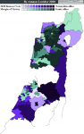
Here's the Negev:


As always, Likudnik development towns (Shas manages second in Dimona, Netivot, and Yemen Field (Ofakim + Neve Menahem in Beer Sheva).
Arad in the Dead sea seat voted for Blue-White and Beitenu over Likud, explained by a backlash against the Hassidic community that's settled there recently, but it's too small to dominate the seat.
I'm not entirely sure I've mapped the Bedouin seats correctly, the electoral commision reports some of the results from tribes and it's really unclear where they fit on the map. It wouldn't make a difference to the results, the Bedouin vote is pretty homogenous (low turnout, >95% Joint List) but it bugs me.
These results show that Jewish villages in the Negev are much more centrist than in the centre of the country. There are religious villages especially around Netivot and towards the West Bank but that's not all the difference.
Fairly interesting dynamics in the Arava (far south). Because it's so sparsely populated, I drew the seat to include some isolated urban areas - Mitzpe Ramon, part of Yeruham, the northern third of Eilat. Rural areas (Kibbutzes mostly) are only 28% of the seat's population, but turnout in Eilat is so low that they make up nearly 40% of votes. Kibbutzes in the Arava consider themselves the heart of the environmentalist movement, hence they vote left, hence the Gantz bloc pulls out a victory but Blue-White alone doesn't. Here's a bonus map of turnout in Eilat:

Next step is some light coding to colour it in automatically. Anyone here tried that?
Here's the Negev:
As always, Likudnik development towns (Shas manages second in Dimona, Netivot, and Yemen Field (Ofakim + Neve Menahem in Beer Sheva).
Arad in the Dead sea seat voted for Blue-White and Beitenu over Likud, explained by a backlash against the Hassidic community that's settled there recently, but it's too small to dominate the seat.
I'm not entirely sure I've mapped the Bedouin seats correctly, the electoral commision reports some of the results from tribes and it's really unclear where they fit on the map. It wouldn't make a difference to the results, the Bedouin vote is pretty homogenous (low turnout, >95% Joint List) but it bugs me.
These results show that Jewish villages in the Negev are much more centrist than in the centre of the country. There are religious villages especially around Netivot and towards the West Bank but that's not all the difference.
Fairly interesting dynamics in the Arava (far south). Because it's so sparsely populated, I drew the seat to include some isolated urban areas - Mitzpe Ramon, part of Yeruham, the northern third of Eilat. Rural areas (Kibbutzes mostly) are only 28% of the seat's population, but turnout in Eilat is so low that they make up nearly 40% of votes. Kibbutzes in the Arava consider themselves the heart of the environmentalist movement, hence they vote left, hence the Gantz bloc pulls out a victory but Blue-White alone doesn't. Here's a bonus map of turnout in Eilat:
Done a mockup, I like it.

In the two-bloc interpretation, the result in 2020 was a 103-96 victory for Bibi over Gantz and we wouldn't be having another election right now. Tipping point was the Megiddo Valley seat (consisting of Likudnik Migdal haEmek and the centre-left communal settlements of the Jezreel Valley).
In the two-bloc interpretation, the result in 2020 was a 103-96 victory for Bibi over Gantz and we wouldn't be having another election right now. Tipping point was the Megiddo Valley seat (consisting of Likudnik Migdal haEmek and the centre-left communal settlements of the Jezreel Valley).
- Location
- Das Böse ist immer und überall
- Pronouns
- he/him
Very nice.
I should update my own one at some point, come to think of it...
I should update my own one at some point, come to think of it...
- Location
- Derbyshire
Very nice indeed.
I do think that way of showing the Palestinian civilian areas works very well.
And I can see there being some very interesting narratives about how the Bibi majority is built entirely from seats in the occupied West Bank.
I do think that way of showing the Palestinian civilian areas works very well.
And I can see there being some very interesting narratives about how the Bibi majority is built entirely from seats in the occupied West Bank.
Hadn't thought of that - and then there'd be a counter narrative that the opposition is nowhere near if not counting Arab seats.Very nice indeed.
I do think that way of showing the Palestinian civilian areas works very well.
And I can see there being some very interesting narratives about how the Bibi majority is built entirely from seats in the occupied West Bank.
 Very healthy.
- Location
- Das Böse ist immer und überall
- Pronouns
- he/him
I think you've neatly encapsulated the reason why this will never actually happen.
Could we see a version of that map with the party results?
Could we see a version of that map with the party results?

View attachment 30064
Likud 94; Blue-White 59; Joint List 29; UTJ 14; Shas 1; Yemina 2
Now that the colouring is mostly automated, any other requests?
Maybe party vote shares by seat could be interesting? Just to zero in on wherever Yamina, the Joint List and so on get their best or their worst results
Maybe party vote shares by seat could be interesting? Just to zero in on wherever Yamina, the Joint List and so on get their best or their worst results
Sure,


