
Would it perhaps be worth using purple for the SFIO and blue for the bottom colour? I know those aren't their actual colours, but it may be worth it for the sake of better distinction. The yellow and orange probably don't matter so much if they're in geographically separated regions.I may have a slight problem.
View attachment 11719
This is the November 1946 National Assembly election, the first held under the constitution of the Fourth Republic (although the two previous constituent assemblies had been elected by almost the exact same system). Most seat colours should be clear, but perhaps not all - I'm going to add descriptions for those on the finished map, along with the fifth or so of seats elected outside the metropole.

-
Hi Guest!
The costs of running this forum are covered by Sea Lion Press. If you'd like to help support the company and the forum, visit patreon.com/sealionpress
You are using an out of date browser. It may not display this or other websites correctly.
You should upgrade or use an alternative browser.
You should upgrade or use an alternative browser.
Max's election maps and assorted others
- Thread starter Ares96
- Start date
Oh boy, very interested in this. Pretty sure RDA was a thing by than, and IIRC, PPA-MTLD and UDMA emerges as a force in the Algerian politics while PCA gets fucked over due to their “The massacre in Setif and Guelma was really both sides issues, si tu réfléchis à ça” *tape ma tête*along with the fifth or so of seats elected outside the metropole.
I may have a slight problem.
View attachment 11719
This is the November 1946 National Assembly election, the first held under the constitution of the Fourth Republic (although the two previous constituent assemblies had been elected by almost the exact same system). Most seat colours should be clear, but perhaps not all - I'm going to add descriptions for those on the finished map, along with the fifth or so of seats elected outside the metropole.
That's so cool, honestly. About time anyone mapped these, considering they're not even online which is ridiculous. I'm looking forward to the non-metropolitan map parts though, those results were crazy lopsided, and the racist distinction between évolués and whites versus others.
Btw Max, are you saving the darker blue shade for the RPF? As it stands right now, I think the colour scheme makes it hard to distinguish between MRP and RAPS, at least on my screen.
- Location
- Das Böse ist immer und überall
- Pronouns
- he/him
Yes, I am. And I would use brown for the modérés, except I’m saving those shades for the Poujadists in 1956. The Fourth Republic is tricky as these things go.Btw Max, are you saving the darker blue shade for the RPF? As it stands right now, I think the colour scheme makes it hard to distinguish between MRP and RAPS, at least on my screen.
- Location
- Das Böse ist immer und überall
- Pronouns
- he/him
That said, the RAPS could easily have another colour. I’d used purple for them in my original doodles, but I think that’s a bit misleading given that they weren’t remotely left-wing.
Purple arguably doesn't have any intrinsic ideological meaning in these maps - besides the fact that parties that actually use it as its colour are from all over the spectrum, it's also sometimes been used (notably on German maps for Die Linke) to mean further to the left than the centre-left which already has red. So I think you can use it as you please.That said, the RAPS could easily have another colour. I’d used purple for them in my original doodles, but I think that’s a bit misleading given that they weren’t remotely left-wing.
- Location
- Das Böse ist immer und überall
- Pronouns
- he/him
Right, all I need to do now is find space to show what the colours of the little mans actually stand for. Will probably end up getting rid of the coat of arms and putting them to the right of the shades.

- Location
- Das Böse ist immer und überall
- Pronouns
- he/him
It's interesting to compare the results of the MRP (which was a centrist Christian democratic party, the first time political Catholicism had really made overt inroads in France) with this map of regular Sunday massgoers as of 1960:
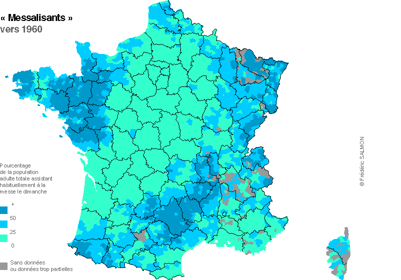
(map courtesy of geoelections.free.fr, which you should go look at if French election maps interest you)
(map courtesy of geoelections.free.fr, which you should go look at if French election maps interest you)
- Location
- Derbyshire
That's just gorgeous.
AO&E 
Would also be bloody hilarious if Alsace and Brittany's MRP had been Muslim lists.
Anyway, the man at the archives said maybe the CEVIPOF had something on the professions de foi of the losers. They don't have them online beyond 1958, but Odile Gaultier-Voituriez might tell you if they have the Fourth or even Third Republic ones and just haven't numerised them if you drop her an e-mail.
EDIT: in fact, the page says they have some going back to 1936, and this lists what they have.
kratostatic
You Wouldn't Steal A Political Party
- Location
- Anyers-upon-Senn, Island-of-France
- Pronouns
- He/him
The original Frankfurt Proposals issued by the Sixth Coalition called for Napoleon to be recognised as ruler of a France whose territories stopped at the Pyrenees in the south, the Alps in the east and the Rhine in the north, the "natural borders" established under the First Republic. Napoleon rejected these terms, believing he could still win the war, and when he was finally defeated in 1814, the terms were much harsher.
Not really related to the excellent maps, but this whole section and this in particular is one hell of a potential PoD given that includes what, Belgium, the Ruhr valley and a large chunk of the Netherlands? I hadn't actually realised how ambitious the "natural borders" were!
- Location
- Das Böse ist immer und überall
- Pronouns
- he/him
The Ruhr proper is east of the Rhine, but Krefeld and Mönchengladbach would indeed be in France. As would the entire Saar basin and the Walloon “sillon industriel”.Not really related to the excellent maps, but this whole section and this in particular is one hell of a potential PoD given that includes what, Belgium, the Ruhr valley and a large chunk of the Netherlands? I hadn't actually realised how ambitious the "natural borders" were!
As concerns the Netherlands, it is worth noting that the borders of 1800, the ones that would probably have been implemented under the Frankfurt Proposals, didn’t include North Brabant but did include Limburg and the southernmost part of Zeeland.
Not really related to the excellent maps, but this whole section and this in particular is one hell of a potential PoD given that includes what, Belgium, the Ruhr valley and a large chunk of the Netherlands? I hadn't actually realised how ambitious the "natural borders" were!
You say ambitious, we say common-sense, only what the French deserved.
- Location
- Das Böse ist immer und überall
- Pronouns
- he/him
I mean, the thing that makes it genuinely interesting is the fact that it would make something like a fifth or a sixth of France’s population (based on pure spitballing) German or Flemish. And while the French school system was very good at ruthlessly integrating the linguistic minorities in the country IOTL, that was mostly speakers of other Romance languages.
I mean, the thing that makes it genuinely interesting is the fact that it would make something like a fifth or a sixth of France’s population (based on pure spitballing) German or Flemish. And while the French school system was very good at ruthlessly integrating the linguistic minorities in the country IOTL, that was mostly speakers of other Romance languages.
Petra lavarout, keneil?
I mean, the thing that makes it genuinely interesting is the fact that it would make something like a fifth or a sixth of France’s population (based on pure spitballing) German or Flemish. And while the French school system was very good at ruthlessly integrating the linguistic minorities in the country IOTL, that was mostly speakers of other Romance languages.
On the other hand in Flanders the prestige language was already French in the 18th-19th centuries so la gauge assimilation would be easier plus it was a fairly poor region so it wouldn’t be surprised if within France there were larger influxes of people from Flanders to Paris further leading to assimilation.
- Location
- Derbyshire
I can see Flanders ending up with a very 'Welsh' situation where the language diminishes only to get a big revivalist movement in the late 20th Century.
The German territories (surely here including Luxemburg and much of Alsace and Lorraine) may well end up getting a bit Irish in politics.
The German territories (surely here including Luxemburg and much of Alsace and Lorraine) may well end up getting a bit Irish in politics.
Walpurgisnacht
It was in the Year of Maximum Danger
- Location
- Banned from the forum
- Pronouns
- He/Him
The German territories (surely here including Luxemburg and much of Alsace and Lorraine) may well end up getting a bit Irish in politics.
I understand you mean 'prominent and occasionally violent separatist movement' but all I can hear in my head is 'HE FIXED LE ROAD'
I understand you mean 'prominent and occasionally violent separatist movement' but all I can hear in my head is 'HE FIXED LE ROAD'
IL A RÉPARÉ LA ROUTE !
- Location
- Das Böse ist immer und überall
- Pronouns
- he/him
Okay, if I didn't support the French Revolution before, I certainly do now.

Last edited: