• Hi Guest!

    The costs of running this forum are covered by Sea Lion Press. If you'd like to help support the company and the forum, visit patreon.com/sealionpress

Max's election maps and assorted others

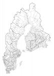
A bit of a useful byproduct of my recent project with @Makemakean - a map of Swedish and Finnish municipalities (as of 1952 for Sweden and 1935 for Finland - although I feel reasonably assured that, less the areas ceded to Russia, there wasn't a shittonne of change to the Finnish boundaries) to the same scale.

I feel yet another TLIAW coming on...

svfi-kommuner.png
 
And if the above was a useful byproduct, the product itself:

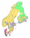
ne-val-1867-v1.png

Note that the colours refer to no election in particular, but rather are meant as a rough indication of each party's strongholds.

In Denmark:
Red: Radikale Højre
Purple: Gamle Højre
Buff: Venstre

Elsewhere:
Grey: Hats
Yellow: Caps
Blue: Unionist Caps
Green: Finnish Peasants' Party
Lilac: Skeptical Party ("Crowns")

The darker grey shade indicates that we've yet to assign parties or (in the case of the German provinces) even constituencies to an area. Also worth noting that there are likely to be a sizeable number of independents in any given election.
 
And a few sacred cows later, here we are.

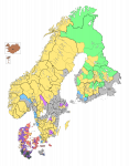
ne-val-1867-v2.png

The lower chamber of the Unionsdag has 528 seats as of the inaugural election, which divide among the constituent countries as follows:

Sweden 198 (154 country, 44 burgher)
Denmark proper 95 (58 country, 37 burgher)
- Slesvig 19 (14 country, 5 burgher)
- Holsten-Lauenborg 28 (19 country, 9 burgher)
Norway 84 (61 country, 23 burgher)
Finland 82 (72 country, 10 burgher)
Pomerania 10 (8 country, 2 burgher)
Iceland 3 (elected indirectly by Althing)
Faroe Islands 1
Union County of Gothenburg 8
 
I assume Karelia has no contemporary subunits with population figures available?

It's actually deliberate!

Karelia was ceded back to Sweden after the Baltic War in 1859. It was established that it was to be under the military administration of a Governor-General for twelve years before being handed over to the civilian administration of the Grand Duchy of Finland after twelve years (that is, in 1871). Consequently, that part of the empire is for election purposes still just one giant at-large district, where they have indirect elections with electors.

Of course, since the Finns (and Russians) have been out of the Nordic countries for over a hundred years, there is no living memory of anything even resembling parliamentary elections there, very strict rules are in place on who is eligible to vote, and who isn't, even stricter on who actually is qualified to stand to be an elector, and so, basically, in most places, the population basically only gets to choose which officer from the army (in many cases from the other side of the Baltic, Swedes speaking no Finnish) they want as their elector. And Swedish military men are loyal Hats, and they're even more loyal to the Governor-General. So, basically, the result ends up being that the ULs elected are what the Governor-General feels sounds like a reasonable approximation of what the result should be, which is an immense number of Hats.

Both me and @Ares96 agree that had it not been for the military administration, the Finnish Agrarians and the Caps would be dominating more or less totally, with the Hats for the most part having no chance in hell of winning.

We don't actually know if any population data exists, we just haven't looked for any.

EDIT: Though I think they should be included in that Finnish census that Ares found. And getting maps for those shouldn't be much of a problem either. Certainly nowhere near the clusterfuck quagmire that was Holstein!
 
Both me and @Ares96 agree that had it not been for the military administration, the Finnish Agrarians and the Caps would be dominating more or less totally, with the Hats for the most part having no chance in hell of winning.
I think the Hats could be competitive in Viborg itself, and maybe the far southwest of the county depending on how far the Swedish language has spread.
 
EDIT: Though I think they should be included in that Finnish census that Ares found. And getting maps for those shouldn't be much of a problem either. Certainly nowhere near the clusterfuck quagmire that was Holstein!
Really, with the possible exception of Iceland (and that’s mainly because I haven’t looked), all the Nordic countries have been amazing at keeping statistics back to the mid-19th century or so available online.
 
Really, with the possible exception of Iceland (and that’s mainly because I haven’t looked), all the Nordic countries have been amazing at keeping statistics back to the mid-19th century or so available online.

What form do they take? Because I've got a lot of fun with census and tables décennales from the French état-civil from the Revolution onwards and the parish records before that are not bad.
 
What form do they take? Because I've got a lot of fun with census and tables décennales from the French état-civil from the Revolution onwards and the parish records before that are not bad.
PDF scans of old publications, generally. You might be interested to know that before WWII, a lot of them have summaries and term translations in French.
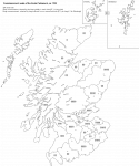
 
Scotland 1703 (constituencies)
Because my Scottish basemap is about to become illegal and also I'm avoiding coursework, have a map of the constituencies for the Scots Parliament as of the last pre-union election.

val-scot-1703.png

This is only part of the chamber, because unlike the English Parliament with its strict division into Lords and Commons, the Estates of the Scots Parliament sat as a single chamber and voted by head (mostly - originally the shire commissioners had to share one vote per shire). Beside the burgh and shire commissioners, there were also ex officio seats for all nobles above the rank of viscount, as well as those created Lords of Parliament by the monarch, and before the Reformation also for prelates. Even though all the monasteries in Scotland were secularised during the Reformation, their "abbots" (i.e. whoever owned the land) retained seats in Parliament, but the bishops' seats were formally abolished by the Covenanters in 1638. Starting with the Union of the Crowns, the monarch also sent a personal representative to Parliament, who received the title of Lord High Commissioner, and performed the parliamentary functions of a head of government.

The union with England in 1707 reduced the number of MPs to 45, but without quite disenfranchising any of the constituencies as such; the burghs (except Edinburgh) were merged into groups of four or five, who chose a member each through an electoral college where each burgh had one vote, and the shires were reduced to one member each. The six smallest shires were grouped into pairs (Bute and Caithness; Clackmannan and Kinross; Cromarty and Nairn), which sent an MP to every other parliament and had no representation in every other one.

EDIT: Also the border between Ross and Cromarty isn't on this because it's an absolute pisstake and also this is a post-1889 basemap.
 
Last edited:
Very nice work Max.

I hope this hasn't rendered any of your work redundant, but Wiki has a map of the vote for the Act of Union in 1707 that includes the Cromartyshire border: https://en.wikipedia.org/wiki/File:...n_the_ratification_of_the_Treaty_of_Union.svg
*idly wonders if there's any correlation between that and IndyRef*
1540054585463.png
Apart from the irony that the "Yes" voting areas were ones that mainly had Commissioners that voted "Yes" to Union, I don't see any. Poo
 
Back
Top